
Beantwoord enkele vragen, en binnen seconden geeft AI je een persoonlijk aankoopadvies op maat.
Beantwoord enkele vragen, en binnen seconden geeft AI je een persoonlijk aankoopadvies op maat.
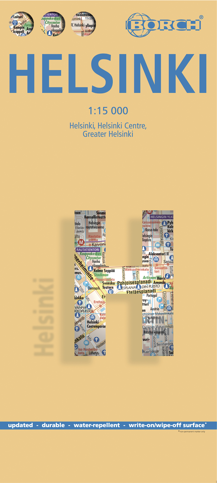
Borch Helsinki is een duidelijke, geplastificeerde plattegrond van het centrum met informatie over openbaar vervoer en bezienswaardigheden. Inclusief straatnamenregister. Our soft-laminated folded map of Helsinki in the 1st edition shows: Helsinki 1:15 000, Helsinki 1:7 500, Greater Helsinki 1:100 000, Public Transport Helsinki, Finland administrative & time zones, Top 30 Sights. Borch Maps show hotels, museums, monuments, markets, public transport, top sights and points of interest, useful statistics, conversion charts for temperatures, weights and measurements, climate charts showing temperatures, sunshine hours, precipitation and humidity, overview maps, time zones, and much more... Called "the daughter of the Baltic", Helsinki is located on the tip of a peninsula and on 315 islands. The Helsinki metropolitan area is home to more than a million people. It has close historical connections with Tallinn, Estonia, Stockholm, Sweden and St. Petersburg, Russia. HelsinkI is the capital and largest city of Finland. Helsinki (Helsingfors in Swedish) is the northernmost metropolitan area in the world. Established by King Gustav I of Sweden in 1550, Helsinki consistently ranks very highly in the worlds top ten most livable cities. Due to the mitigating influence of the Baltic Sea and the North Atlantic Current, temperatures in winter are higher than the northern location might suggest, with temperatures in January and February averaging -5 C. Helsinki is also known as a hub of industrial design! In Helsinki slang the city is called Stadi (from the Swedish word stad, meaning "city").This truly fine city must be seen.
€9,95
Bekijk product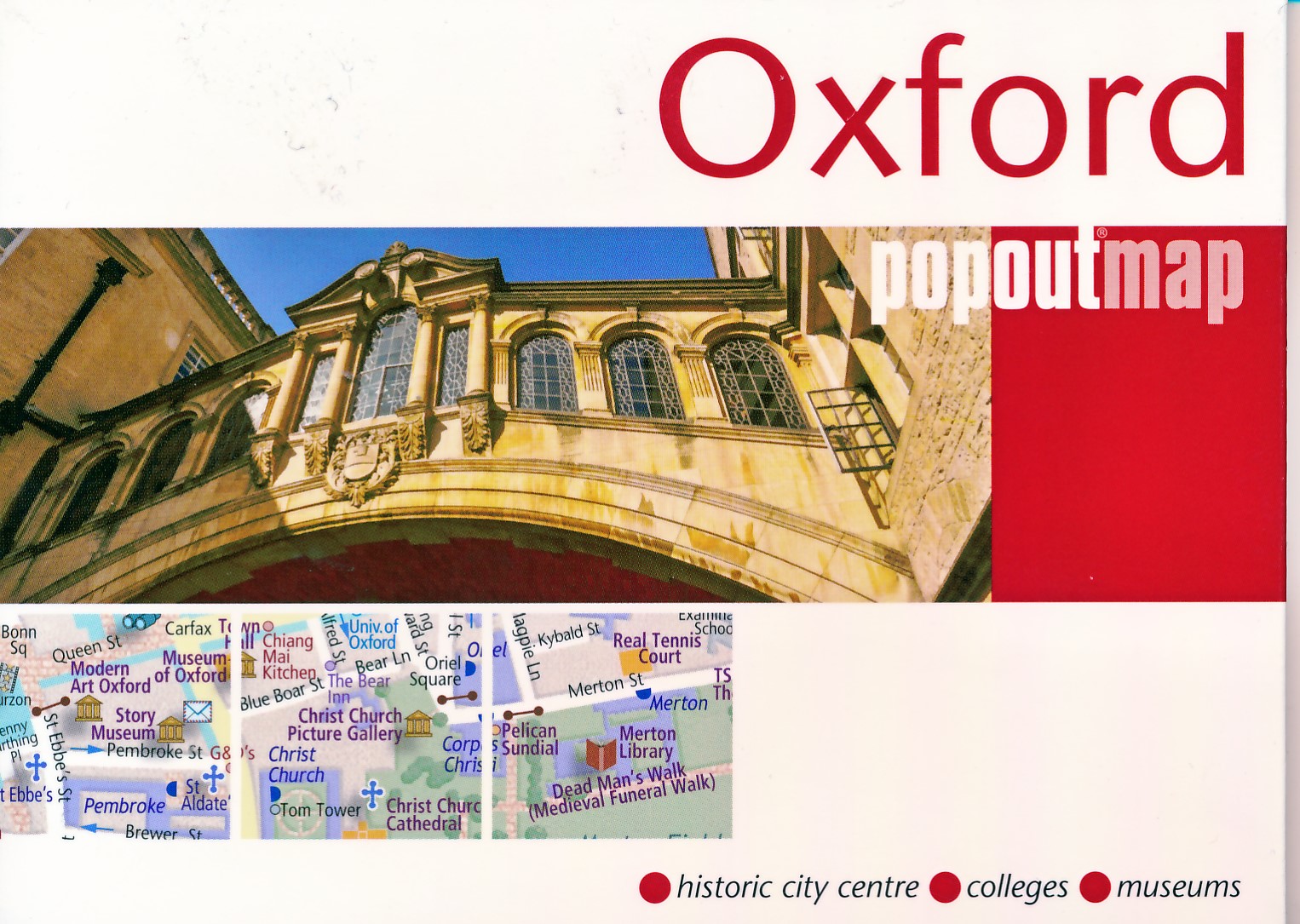
Handig ( borstzak- ) formaat stadsplattegrond met voldoende detail, zodat je ook de kleinere straatjes erop aantreft. Van veel wereldsteden inmidddels leverbaar en dat is mooi, want juist in dit soort steden wil je je handen liever vrij houden en niet teveel hoeven stoeien met het uitvouwen van een grote plattegrond, en/of teveel als "toerist" opvallen. Door het unieke vouwsysteem blijft alles zeer compact en biedt het kaartje een razendvlugge manier van orientatie. Wel is dit product alleen geschikt voor het ( grote ) centrum van de stad.Verder geven de kaartjes uit deze reeks ook de meeste highlights van de stad aan en ( indien van toepassing ) een overzichtskaartje van de metro. Experience the elegant university city of Oxford (UK) with the help of this genuinely pocket-sized, pop-up map. Small in size yet big on detail, this compact, dependable, city map of Oxford will ensure you don't miss a thing. * Includes a PopOut map - a detailed street map of the city center * Advice on the top things to see while you re there including colleges, museums, university buildings, places of interest, parks and walks * Handy, self-folding, tourist map is small enough to fit in your pocket yet offers extensive coverage of the city in an easy-to-use format * Thorough street index is also featured and cross-referenced to the map so you can easily find your destination * Hotels, restaurants, stores and attractions are all included on the map Ideal to pop in a pocket or bag for quick reference while exploring the city."
€7,95
Bekijk product
De stadsplattegronden van Lonely Planet zijn uitgevoerd op scheur- en watervast papier, zijn lichtgewicht en kennen een handig formaat. Het centrum van de stad is in heldere kleuren in beeld gebracht met straatnamen, bezienswaardigheden en symbolen voor openbaar vervoer. Op de achterzijde staat informatie over de toeristische hoogtepunten en in de meeste gevallen een schematische plattegrond van het openbaar vervoer. Met een register. Durable and waterproof, with a handy slipcase and easy-fold format, Lonely Planet’s Copenhagen City Map helps you navigate with ease. Get more from your map and your trip with images and information about top city attractions, walking tour routes, transport maps, itinerary suggestions, extensive street and site index, and practical travel tips and directory. With this easy-to-use, full-colour map in your back pocket, you can truly get to the heart of Copenhagen. Durable and waterproof Easy-fold format and convenient size Handy slipcase Full colour and easy to use Extensive street and site index Images and information about top city attractions Handy transport maps Walking tour routes Practical travel tips and directory Itinerary suggestions Covers Christianshavn, Frederiksberg, Latin Quarter, Nyhavn, Nørrebro, Nørreport, Østerport, Slotsholmen, Strøget, Tivoli, Vesterbro
€10,95
Bekijk product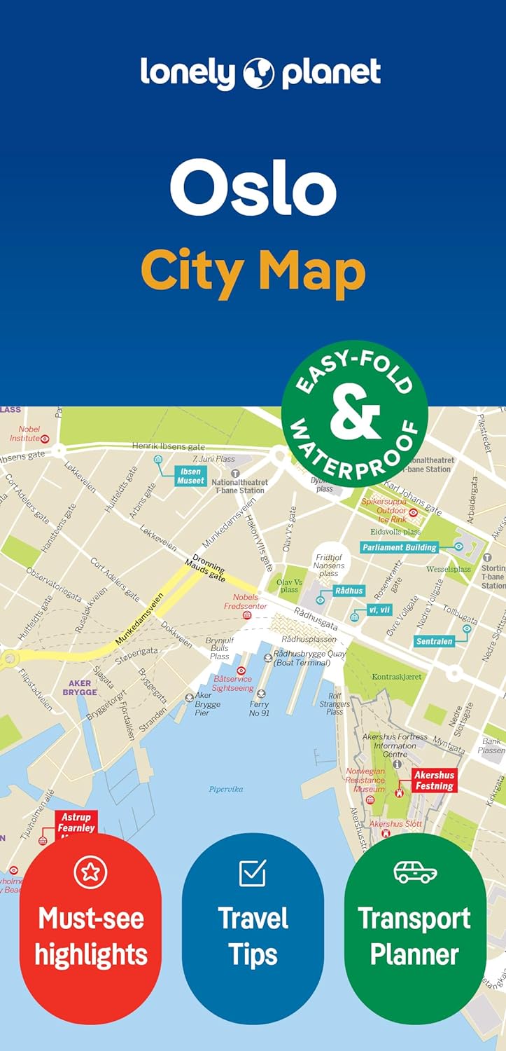
De stadsplattegronden van Lonely Planet zijn uitgevoerd op scheur- en watervast papier, zijn lichtgewicht en kennen een handig formaat. Het centrum van de stad is in heldere kleuren in beeld gebracht met straatnamen, bezienswaardigheden en symbolen voor openbaar vervoer. Op de achterzijde staat informatie over de toeristische hoogtepunten en in de meeste gevallen een schematische plattegrond van het openbaar vervoer. Met een register. Durable and waterproof, with a handy slipcase and an easy-fold format, Lonely Planet's Oslo City Map is your conveniently sized passport to travelling with ease. Get more from your map and your trip with images and information about top city attractions, walking tour routes, transport maps, itinerary suggestions, an extensive street and site index, and practical travel tips and directory. With this easy-to-use, full-colour navigation tool in your back pocket, you can truly get to the heart of Munich, so begin your journey now! Durable and waterproof Easy-fold format and convenient size Handy slipcase Full colour and easy to use Extensive street and site index Images and information about top city attractions Handy transport maps Walking tour routes Practical travel tips and directory Itinerary suggestions Covers Aker Brygge, Barcode, Bislett, Bjorvika, Bygdøy, Damstredet, Frogner, Gimle, Grønland, Grünerlokka, Opera House Looking for more extensive coverage? Check out Lonely Planet's Norway, our most comprehensive guidebook to the country, covering the top sights and most authentic offbeat experiences. Or check out Lonely Planet's Pocket Oslo, a handy-sized guide focused on the can't-miss experiences for a quick trip. About Lonely Planet: Lonely Planet is a leading travel media company, providing both inspiring and trustworthy information for every kind of traveller since 1973. Over the past four decades, we've printed over 145 million guidebooks and phrasebooks for 120 languages, and grown a dedicated, passionate global community of travellers. You'll also find our content online, and in mobile apps, videos, 14 languages, armchair and lifestyle books, ebooks, and more, enabling you to explore every day. 'Lonely Planet guides are, quite simply, like no other.' New York Times 'Lonely Planet. It's on everyone's bookshelves; it's in every traveller's hands. It's on mobile phones. It's on the Internet. It's everywhere, and it's telling entire generations of people how to travel the world.' Fairfax Media (Australia)
€10,95
Bekijk product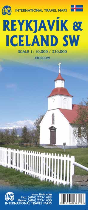
Een dubbelzijdige kaart met aan de ene kant een plattegrond van Reykjavík, schaal 1:10.000. Aan de andere zijde een overzichtskaart van zuidwest Ijsland, schaal 1:330.000, met aanduidingen van o.a. nationale parken, vliegveld, benzinepomp, dirt-roads.
€13,95
Bekijk product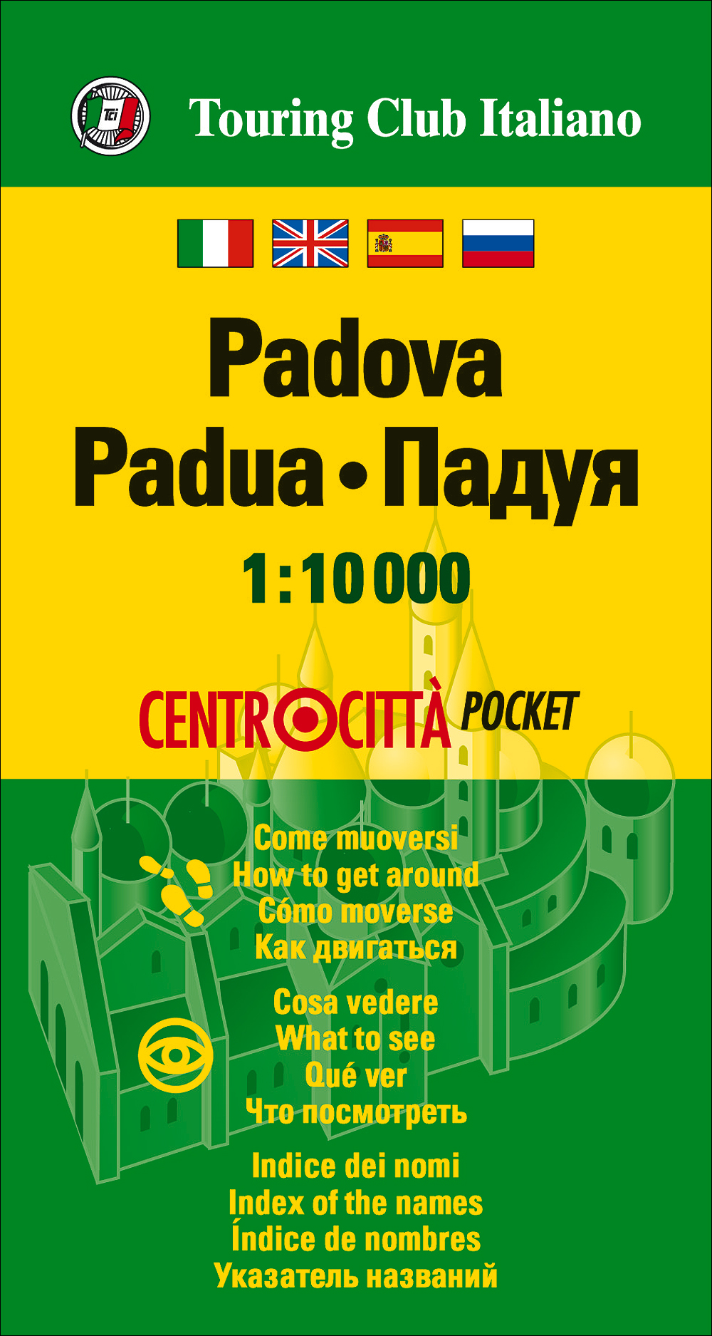
Handige pocket stadsplattegrond van Padua. Alle belangrijke informatie vind je er op terug met een register. Bedenk wel dat het een centrumkaart is, de buitenwijken zul je er niet op terugvinden.
€7,95
Bekijk product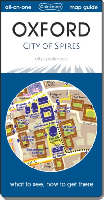
OUDE DRUK Handzame en handige plattegrond van het centrum van Oxford . Bezienswaardighden, bekende en minder bekende en openbaar vervoer vind je er op terug. Er zit geen register bij, gewoon een toeristische kaart van het centrum van de stad.
€2,95
Bekijk product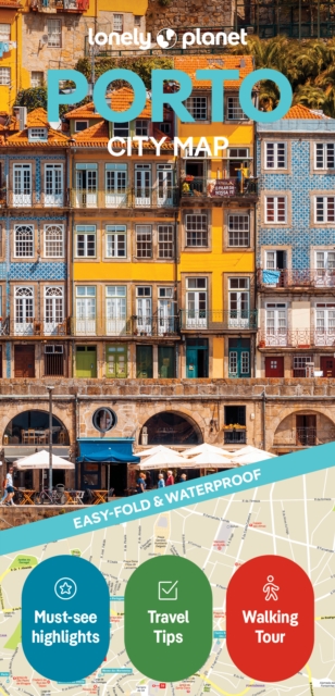
De stadsplattegronden van Lonely Planet zijn uitgevoerd op scheur- en watervast papier, zijn lichtgewicht en kennen een handig formaat. Het centrum van de stad is in heldere kleuren in beeld gebracht met straatnamen, bezienswaardigheden en symbolen voor openbaar vervoer. Op de achterzijde staat informatie over de toeristische hoogtepunten en in de meeste gevallen een schematische plattegrond van het openbaar vervoer. Met een register. Durable and waterproof, with a handy slipcase and an easy-fold format, Lonely Planet's Porto City Map is your conveniently sized passport to travelling with ease. With this easy-to-use, full-colour navigation tool in your back pocket, you can truly get to the heart of Porto, so begin your journey now! Durable and waterproof Easy-fold format and convenient size Handy slipcase Full colour and easy to use Extensive street and site index Images and information about top city attractions Handy transport maps Walking tour routes Practical travel tips and directory Itinerary suggestions Covers Afurada, Boavista, Cedofeita, Fontaínhas, Foz do Douro, Massarelos, Miragaia, Ribeira, Serralves, Vila Nova de Gaia Looking for more extensive coverage? Check out Lonely Planet's Experience Portugal, our most comprehensive guidebook to the country, covering the top sights and most authentic offbeat experiences. Or check out Lonely Planet's Pocket Porto, a handy-sized guide focused on the can't-miss experiences for a quick trip.
€10,95
Bekijk product

De stadsplattegronden van Lonely Planet zijn uitgevoerd op scheur- en watervast papier, zijn lichtgewicht en kennen een handig formaat. Het centrum van de stad is in heldere kleuren in beeld gebracht met straatnamen, bezienswaardigheden en symbolen voor openbaar vervoer. Op de achterzijde staat informatie over de toeristische hoogtepunten en in de meeste gevallen een schematische plattegrond van het openbaar vervoer. Met een register. Durable and waterproof, with a handy slipcase and easy-fold format, Lonely Planet’s Lisbon City Map helps you get around with ease. Get more from your map and your trip with images and information about top city attractions, walking tour routes, transport maps, itinerary suggestions, extensive street and site index, and practical travel tips and directory. With this easy-to-use, full-color map in your back pocket, you can truly get to the heart of Lisbon. Durable and waterproof Easy-fold format and convenient size Handy slipcase Full colour and easy to use Extensive street and site index Images and information about top city attractions Handy transport maps Walking tour routes Practical travel tips and directory Itinerary suggestions Covers Alfama, Castelo, Graça, Baixa, Rossio, Bairro Alto, Chiado, Marquês de Pombal, Rato, Saldanha, Estrela, Lapa, Alcântara, Belém, Parques das Nações
€10,95
Bekijk product