
Beantwoord enkele vragen, en binnen seconden geeft AI je een persoonlijk aankoopadvies op maat.
Beantwoord enkele vragen, en binnen seconden geeft AI je een persoonlijk aankoopadvies op maat.

Borch Bangkok is een duidelijke, geplastificeerde plattegrond van het centrum met informatie over openbaar vervoer en bezienswaardigheden. Inclusief straatnamenregister. Our soft-laminated folded map of Bangkok shows: Bangkok City 1:14 000, Wat Phra Kaeo & Royal Grand Palace 1:6 000, Bangkok & Region 1:100 000, Public Transport Bangkok, Top 30 Sights, Thailand administrative and time zones. Borch Maps are easy to fold, durable and water-repellent with a wipeable surface. Borch Maps show hotels, museums, monuments, markets, public transport, top sights and points of interest, useful statistics, conversion charts for temperatures, weights and measurements, climate charts showing temperatures, sunshine hours, precipitation and humidity, overview maps, time zones, and much more... Krung Thep Maha Nakhon (Bangkok) on the Chao Phraya river is the capital city of Thailand and the country's economic center. It is one of the most populous cities in the world with its number of inhabitants very roughly estimated at somewhere between 6 and 22 million people. Bangkok is the modern skyscraper-lined gateway to Asia and one of the region's largest air transport hubs. The city has plenty of parks and green zones, a surprisingly laid-back atmosphere, a tropical monsoon climate and higher temperatures than in any other city in the world. Over 90% of its inhabitants are Buddhist. The city is known as a safe destination - overcharging and petty theft are far more common than violent crime, which is rare. Tourist sights are in abundance and include countless palaces, famous temples and other cultural highlights. Bangkok also offers relaxing retreats nearby, luxurious shopping, and many insights into the fascinating culture of Thailand.
€9,95
Bekijk product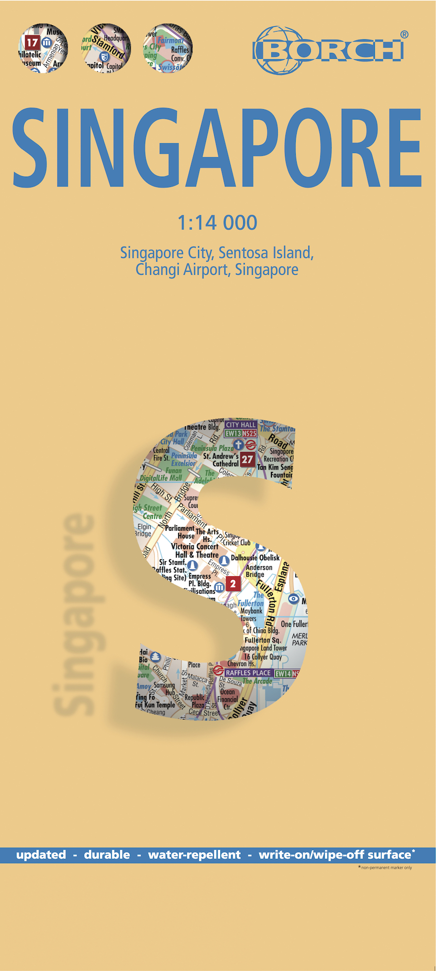
Borch Singapore is een duidelijke, geplastificeerde plattegrond van het centrum met informatie over openbaar vervoer en bezienswaardigheden. Inclusief straatnamenregister. Our soft-laminated folded map of Singapore shows: Singapore City 1:14 000, Singapore 1:120 000, Sentosa Island 1:25 000, Changi Airport 1:4 000 and the Public Transportation SMRT schematic map. Borch Maps are easy to fold, durable and water-repellent with a wipeable surface. Borch Maps show hotels, museums, monuments, markets, public transport, top sights and points of interest, useful statistics, conversion charts for temperatures, weights and measurements, climate charts showing temperatures, sunshine hours, precipitation and sea temperatures, overview maps and much more... The Republic of Singapore (also known as "Lion City", although history tells us Singapore's founder probably meant "tigers") is a very clean and orderly city-state located on the southern tip of the Malay Peninsula, with Changi airport usually placed at the top of the "world's best" lists. It is the fifth wealthiest country in the world and the smallest state in southeastern Asia, although far larger than Monaco and Vatican City (the world's only other sovereign city-states). It is the only Asian country which has English as its first language, 36% of its population are foreigners, it is the second most densely populated country in the world and its standards in just about everything are very high. Singaporean cuisine is diverse and delicious and like the culture a blend of Chinese, Malay, Indian and Arabic influences. Independence from Britain was declared in 1963 and Singapore gained its sovereignty in 1965. See the Orchard Road, the temples, Singapore Zoo, go on a night safari, eat at the food courts, pay homage to Sir Stamford Raffles (the founder of modern-day Singapore) by enjoying a Singapore Sling in the world-famous Long Bar in Raffles Hotel, see the casinos at Sentosa Resort, the list of attractions is far too long for this small space.
€9,95
Bekijk product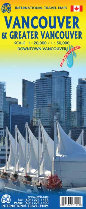
Stadsplattegrond van Vancouver met een extra inzet op kleinere schaal van het centrum. Met register. Waterproof! ITMB first published our own map of Vancouver six editions and twenty years ago. Each time we update, we're surprised at how much change has taken place. This is a double-sided map, with the city on one side and the metropolitan area on the other side. Like many North American cities, Vancouver consists of several separate urban areas that have merged together physically but not politically. Greater Vancouver's population is 2,500,000, most of which consists of residential areas. The 'regional' side is where the growth in population is taking place (about 100,000 people move to Vancouver each year) and this is where noticeable developments are taking place - the new South Perimeter Road following the Fraser River eastwards, the new Port Mann toll bridge, the new toll Golden Ears toll bridge across the Fraser. None of this will make sense to non-locals, but since most of our copies sell locally, our press releases have to mention details that may seem irrelevant to people further away. For such people, the latest and greatest map for visitors to Vancouver is now on plastic. Legend Includes: Roads by classification, Railroads with stations, Skytrain lines, Trains, Buses, Ferries, Ski lift, City border, Hotels, Police stations, Main post offices, Gas stations, Major places of workship, Parks with hiking trails and playgrounds, GVRD and provincial parks, Tourist information centers and points of interest, Marinas, Lighthouses, Hospital and care centers, Universities, Libraries, Community centres, Beaches, Shopping centres and malls, Live theatres, Cinemas, Museums, Galleries, Picnic areas, Golf courses, Sport fields, Stadiums, and much more.
€13,95
Bekijk product
Stadsplattegrond met register. Helder kaartbeeld waarbij de naamgeving goed leesbaar is weergegeven. Met de toeristische bezienswaardigheden in symbolen weergeven: monumenten, musea, stadions e.a. Daarnaast handige zaken als postkantoren, parkeergarages en stations. Veelal ook met een openbaar vervoer of metro kaart als inzet.
€13,95
Bekijk product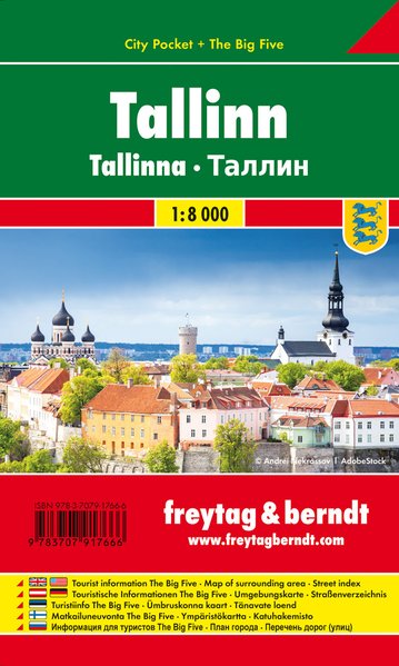
Stadsplattegrond met register in handig zakformaat en geplastificeerd. Helder kaartbeeld waarbij de naamgeving goed leesbaar is weergegeven. Met de toeristische bezienswaardigheden in symbolen weergeven: monumenten, musea, stadions e.a. Daarnaast handige zaken als postkantoren, parkeergarages en stations. Veelal ook met een openbaar vervoer of metro kaart als inzet Der City Pocket Stadtplan Tallinn 1:10.000 bietet zahlreiche Zusatzinformationen und Sehenswürdigkeiten. Im umfangreichen Index finden Sie außerdem alle Adressen. Alle Inhalte werden natürlich regelmäßig aktualisiert. Die Titel der „City Pocket“ – Reihe passen durch das handliche Format von 9 x 15 cm in jede Tasche. Sie sind wasserfest und daher für jedes Abenteuer geeignet! Details: Touristische Informationen “The Big Five”: Einkaufen, Kulinarik, Kultur, Nachtleben, Sehenswürdigkeiten, Umgebungskarte, Straßenverzeichnis.
€8,95
Bekijk product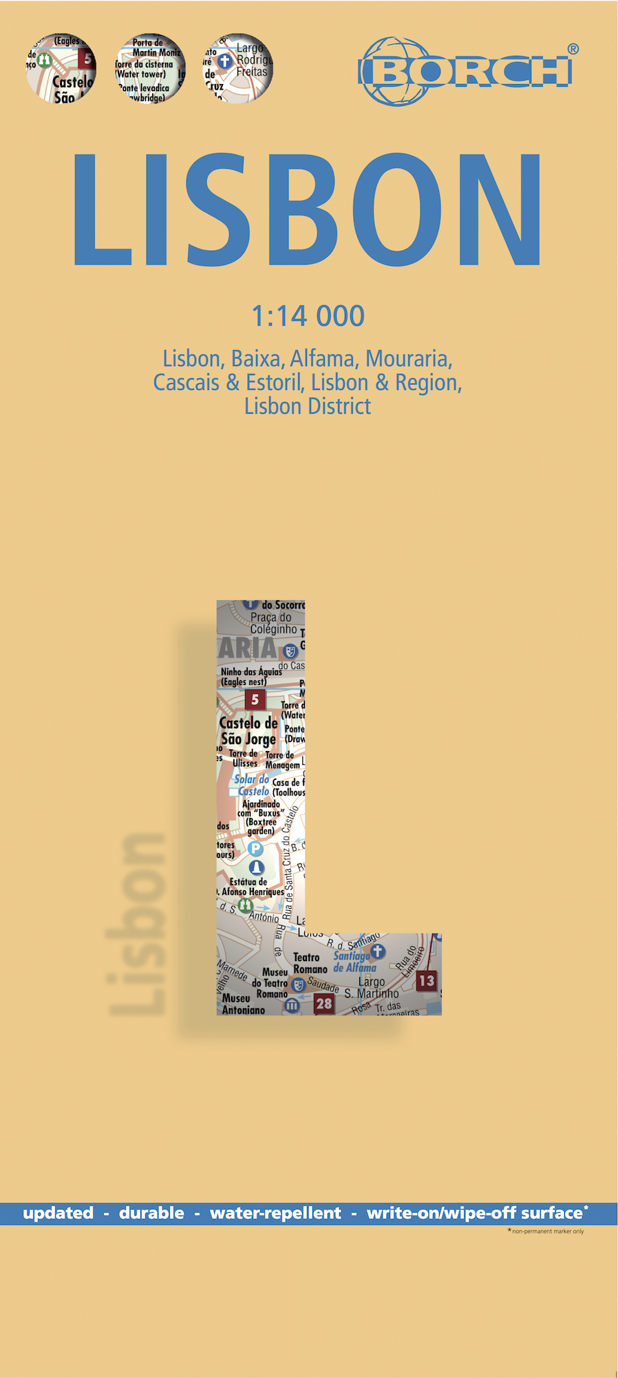
Borch Lissabon is een duidelijke, geplastificeerde plattegrond van het centrum met informatie over openbaar vervoer en bezienswaardigheden. Inclusief straatnamenregister. Our soft-laminated folded map of Lissabon shows: Lisbon 1:14 000, Baixa, Alfama, Mouraria 1:8 250, Cascais & Estoril 1:12 500, Lisbon & Region 1:135 000, Lisbon District 1:650 000, Portugal administrative & time zones, Public Transport Lisbon and Top 30 sights. Borch Maps show hotels, museums, monuments, markets, public transport, top sights and points of interest, useful statistics, conversion charts for temperatures, weights and measurements, climate charts showing temperatures, sunshine hours, precipitation and humidity, overview maps, time zones, and much more... Lisbon is the capital, largest city and political center of Portugal, and the westernmost capital city in central Europe. It has been invaded by the Romans, Moors and even Napoleon and boasts some fabulous historical sites and architecture all bearing testimony to its rich cultural heritage. Lisbon has an agreeable Mediterranean climate strongly influenced by the warm Gulf Stream and an excellent public transport system, which will bring you to the many palaces, museums, galleries and other sights, swiftly and safely. The Baixa district is the heart of the city, Alfama is the oldest district, and lovely Cascais is a coastal town famous for its charming center and sports events. Portuguese cuisine and wine are excellent, make sure you try the famous grilled sardines.
€9,95
Bekijk product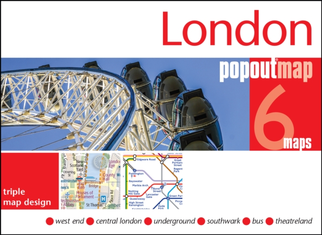
Handig ( borstzak- ) formaat stadsplattegrond met voldoende detail, zodat je ook de kleinere straatjes erop aantreft. Van veel wereldsteden inmidddels leverbaar en dat is mooi, want juist in dit soort steden wil je je handen liever vrij houden en niet teveel hoeven stoeien met het uitvouwen van een grote plattegrond, en/of teveel als "toerist" opvallen. Door het unieke vouwsysteem blijft alles zeer compact en biedt het kaartje een razendvlugge manier van orientatie. Wel is dit product alleen geschikt voor het ( grote ) centrum van de stad.Verder geven de kaartjes uit deze reeks ook de meeste highlights van de stad aan en ( indien van toepassing ) een overzichtskaartje van de metro. London PopOut Map: pop-up city street map of London city centre - folded pocket size travel map with transit map included Contents include maps of: West End Central London Underground Tube Map Bus Routes Theatreland The ultimate pocket map of London! Explore London with the help of this genuinely pocket-sized, pop-up map. Small in size, yet big on detail, this compact, dependable city map will ensure you don't miss a thing. * Includes two pop-up maps covering the West End and Central London * Additional maps covering the Underground, buse routes and Theatreland are also included * Handy, self-folding tourist map is small enough to fit in your pocket yet offers extensive coverage of the city in an easy-to-use format * Thorough street index is also featured and cross-referenced to the map so you can easily find your destination * Hotels, restaurants, stores and attractions are all included
€7,95
Bekijk product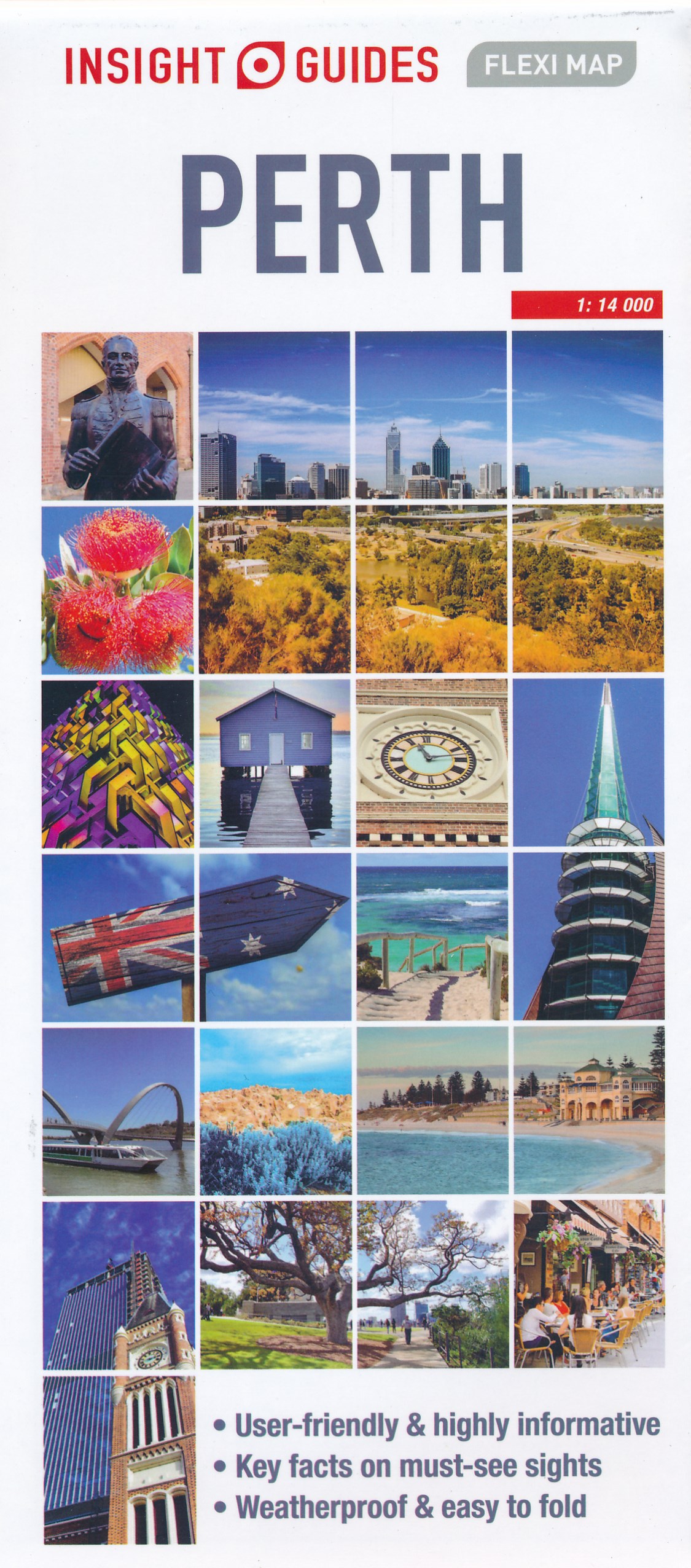
Geplastificeerde centrumkaart van Perth, met register. Voor de 'gewone' toerist een handige kaart, geen groot formaat, overzichtelijk met alle belangrijke plaatsen goed weergegeven. This laminated fleximap of Perth contains six maps, including Perth City, Perth environs, Perth Urban area, Fremantle, and an overview regional map. It also gives overviews of the top recommended sights and places to visit, as well as practical data, climate tables and local transport details. The key features include: detailed cartography highlights all the main tourist sights and provides valuable motoring information; informative text - essential facts about the destination are provided, plus handy tips for getting around...; ease of use - the durable maps fold very easily, even when it's raining; and laminated finish - you can write on the map with a non-permanent marker pen and wipe it off later.
€9,95
Bekijk product
Een overzichtelijke stadsplattegrond met stratenindex (achterzijde) en aanduiding van toeristische informatie en culturele instellingen zoals musea, monumenten, schouwburgen en sportaccomodaties. Daarnaast bevaten de meeste kaarten een heldere aanduiding van het openbaarvervoer (opstappunten van bijvoorbeeld de metro, tram of bus), parkeergelegenheden, postkantoren en andere praktische informatie.
€8,95
Bekijk product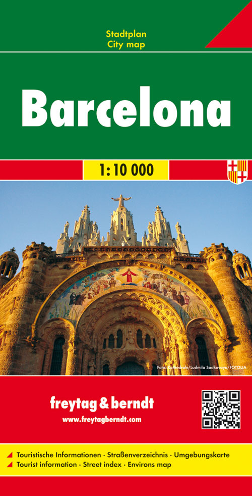
Stadsplattegrond met register. Helder kaartbeeld waarbij de naamgeving goed leesbaar is weergegeven. Met de toeristische bezienswaardigheden in symbolen weergeven: monumenten, musea, stadions e.a. Daarnaast handige zaken als postkantoren, parkeergarages en stations. Veelal ook met een openbaar vervoer of metro kaart als inzet. Explore Barcelona with this Freytag & Berndt map. The best way to plan your trip, prepare your itinerary, and to travel independently in this country. As with all Freytag & Berndt maps the cartography is clear and detailed with the topography shown by relief shading with plenty of spot heights. One side features a detailed map of the city of Barcelona, as well as an inset of the greater area around the city in Spain. The flipside features the index for the map. Freytag & Berndt maps make good use of an icon system. Icons show tourist information such as: Places of interest Churches, museums and theatres Parks and gardens Distances between points are shown as well as indications of steep gradients, all distances are in kilometres. The legend is in several languages including English.
€13,95
Bekijk product