
Beantwoord enkele vragen, en binnen seconden geeft AI je een persoonlijk aankoopadvies op maat.
Beantwoord enkele vragen, en binnen seconden geeft AI je een persoonlijk aankoopadvies op maat.
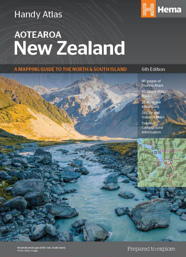
Kleine handzame wegenatlas van Nieuw Zeeland. Tour the land of the long white cloud with New Zealand’s clearest and most up-to-date maps – the hard work's all taken care of. There's something for every kind of traveller among these meticulously crafted maps and guides, with more than 1500 motorhome parks, adventure activity locations, camping grounds and additional city and national park maps. All presented in an easy to read, easy to store format – finally putting an end to back-road map rage. With so much to see and do you'll be glad to have this comprehensive travel companion at your side, helping you cut down the planning time so you have time to explore! Key Features • 80 pages of touring maps • 10 “Great Walks” tracks • 25 must-see attractions • 28 City Maps • Detailed campground information • Extensive and updated information on the NZ “Great Walks”
€22,50
Bekijk product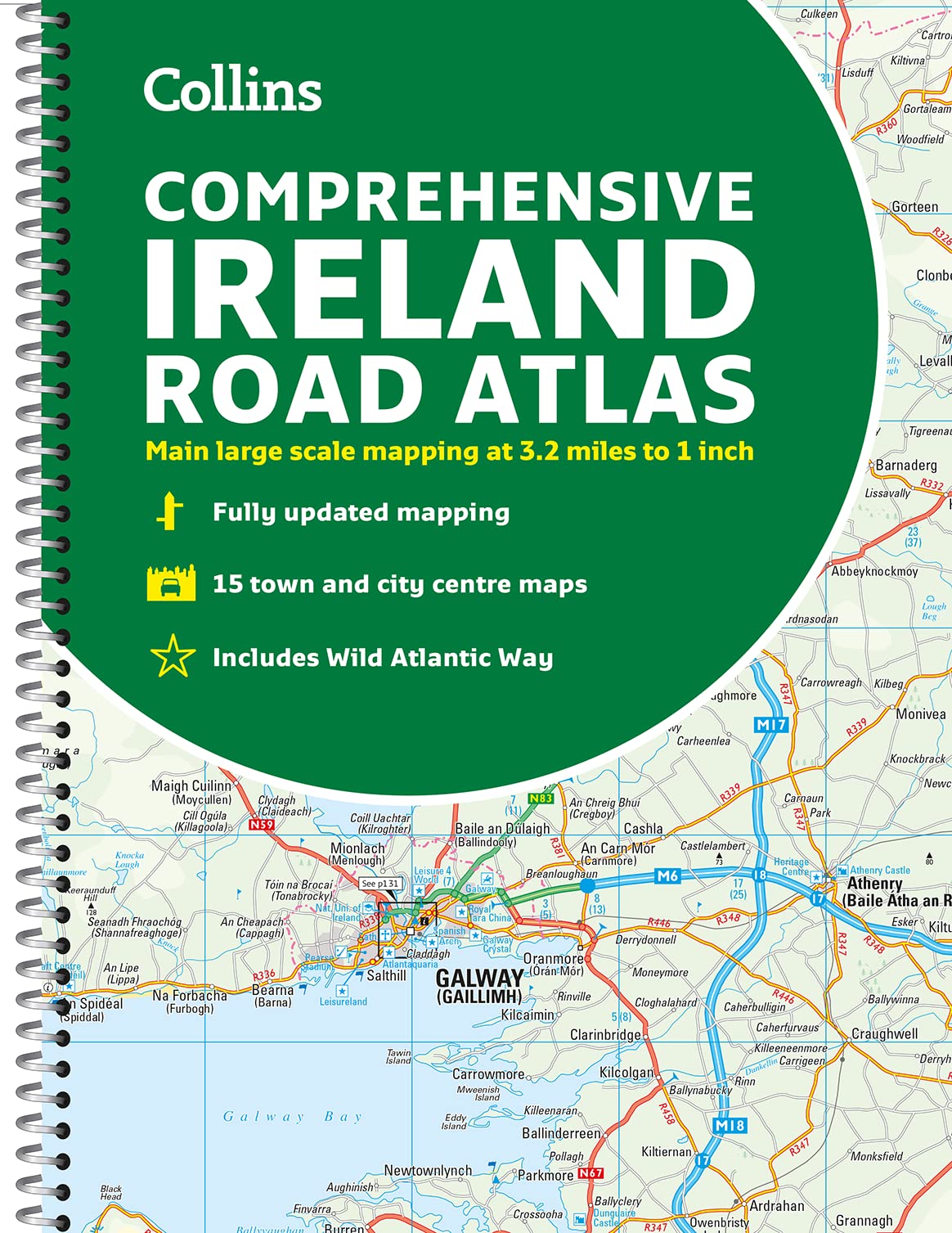
Duidelijke en gedetailleerde atlas voor Ierland in A4-formaat met ringband. Clear, detailed road atlas of Ireland in a handy A4 spiral-bound format. This comprehensive, general purpose road atlas of the whole of Ireland is ideal for both business and pleasure use. The atlas contains a range of mapping scales: • 9 miles to 1 inch route planning map • Main maps at 3.2 miles to 1 inch, which are ideal for navigation. • A wide selection of detailed town centre street plans. This edition boasts road mapping packed with detail showing colour classified road network, toll roads, land heights, the location of safety cameras, Blue Flag and Green Coast beaches, tourist information centres and a wide range of tourist attractions. There is also comprehensive guide information for visitors to Belfast, Cork, Dublin and Limerick. The locations of Speed Enforcement Zones, which highlight roads that have a high risk of accidents as identified by the Garda and the National Roads Authority, are included. There is also a wide range of fully indexed town and city centre maps. These are: Bangor, Belfast, Cork, Drogheda, Dublin, Dn Laoghaire, Galway, Kilkenny, Killarney, Limerick, Lisburn, Londonderry (Derry), Newry, Newtownabbey and Waterford.
€14,95
Bekijk product
Atlas van de alpen door Marco Polo, bevat zuid-oostelijk deel Frankrijk, Zwitserland, Oostenrijk, Slovenië, noorden van Italië tot voorbij Rome, groot gedeelte van Kroatie en kleine delen van de omliggende landen op schaal 1:300.000. Praktische en toeristische informatie is op de kaarten aangegeven. Inclusief 22 plattegronden van belangrijke steden en kaartenmateriaal van overig Europa op schaal 1:4.500.000.. In spiraaluitvoering. Marco Polo: Mit landschaftlich schönen Strecken und Sehenswürdigkeiten. Übersichtskarte zum Ausklappen, Entfernungstabelle, Ortsregister, 22 Citypläne, Europateil. 1: 300.000, Europa 1 : 4.500.000
€17,50
Bekijk product
Wegenatlas, met spiraal, van Groot-Brittannie, Engeland, Wales en Schotland, met toeristische informatie This top-selling road atlas showcases Britain’s clearest mapping from the experts at the AA at a large 3.2 miles to 1 inch scale. Each page has been titled with its geographical location so you can turn to the page you need more easily. Wide and narrow minor roads, National Trust, English and World Heritage sites and hard-to-find places are shown. There are 112 city, town, port and airport plans, full colour country, unitary and administrative area map and a comprehensive 31,500 entry index with airports, top tourist sites and motorway services listed. Plus, scenic routes, over 1,800 golf courses and the top 300 AA-Inspected caravan and camping sites symbolised on the mapping. Motorway maps, ferry planning information and 5 district maps provide the essential motoring content for travelling the country. 10 pages of central London street mapping with index. District maps of Birmingham, Glasgow, London, Manchester and Tyne & Wear. 6 page clear Route Planner map.
€24,95
Bekijk product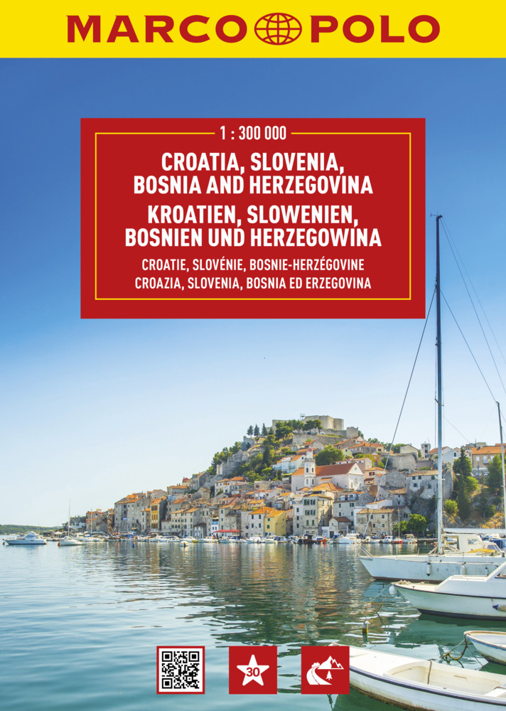
Uitstekende wegenatlas van Slowenië, Kroatië, Bosnië & Hercegovina op een behoorlijk gedetailleerde schaal. Wegen zijn met wegnummers aangeduid, afstanden tussen hoofdplaatsen staan er duidelijk op en met symbolen worden allerlei toeristische hoogtepunten weergegeven. Der MARCO POLO Reiseatlas zeichnet sich durch moderne Kartographie aus und bildet Kroatien, Slowenien und Bosnien im optimalen Maßstab 1:300 000 ab. Mit Highlights aus Kultur und Natur und landschaftlich schönen Strecken wird dein Roadtrip damit zum echten Erlebnis. Länder- und Reiseinformationen bewahren dich vor dem Knöllchen, und das praktischen Zoom-System bietet von der Europakarte bis zum Stadtplan immer das richtige Kartendetail, sowohl für die Planung als auch während der Fahrt. Erläuterung Zoomsystem/ Navigator Blattübersicht/ Übersichtskarte zum Ausklappen mit Highlights/ Marco Polo Highlights/ Kartenteil im Maßstab 1:4,5 Mio mit Blattübersicht und Legende/ Kartenteil im Maßstab 1:300 000 für Kroatien, Slowenien und Bosnien & Herzegowina mit mehrsprachiger Legende (SLO, HR, D, GB, I, E, F, NL, CZ, PL, H, DK)/ Kartenteil 1:150 000 mit Blattübersicht und Legende/ - Ljubliana - Maribor - Mostar - Sarajevo - Split - Zagreb Kartenteil 1:20 000 mit Blattübersicht und Legende - Cetinje 1:10 000 - Dubrovnik - Kotor 1:5 000 - Ljubljana - Maribor 1:15 000 - Mostar - Rijeka - Sarajevo - #ibenik - Split - Trieste - Trogir - Zadar 1:15 000 - Zagreb/ Reiseinformationen/ Ortsregister nach Ländern mit PLZ und Sehenswürdigkeiten, Gebirgen, Gewässer etc./ Entfernungstabelle.
€18,95
Bekijk product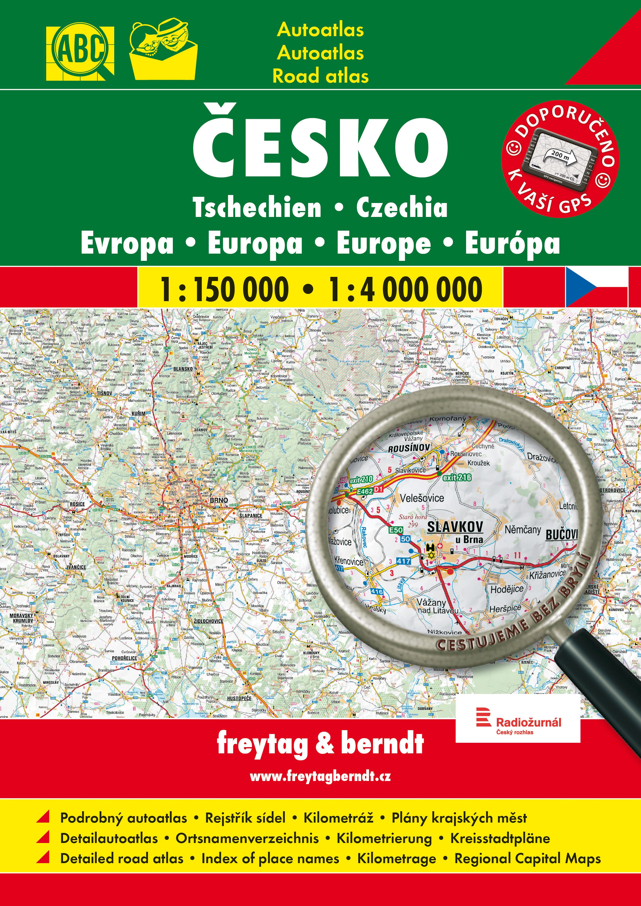
Goede, gedetailleerde wegenatlas van Tsjechië, met register, schaal 1:150.000 + Europa 1:400.000 De berijdbare wegen zijn goed weergeven, zowel de hoofdwegen als provinciale en lokale wegen; wegnummers worden vermeld. Afstanden tussen plaatsen zijn in kilometers op de kaart ingetekend, daarnaast worden ook op belangrijke plekken benzinepompen gemarkeerd. In het kaartbeeld wordt door middel van schaduw het reliëf weergegeven en soms enkele punten in het landschap met de daadwerkelijke hoogte. Provinciegrenzen zijn goed terug te vinden, nationale parken en reservaten ook. Met allerhande symbolen worden toeristische bezienswaardigheden weergegeven als monumenten, historisch belangrijke plekken en uitzichtpunten. In bepaalde plaatsen zijn hotels en campings te vinden, luchthavens, treinverbindingen en havens vindt u er ook op!
€23,95
Bekijk product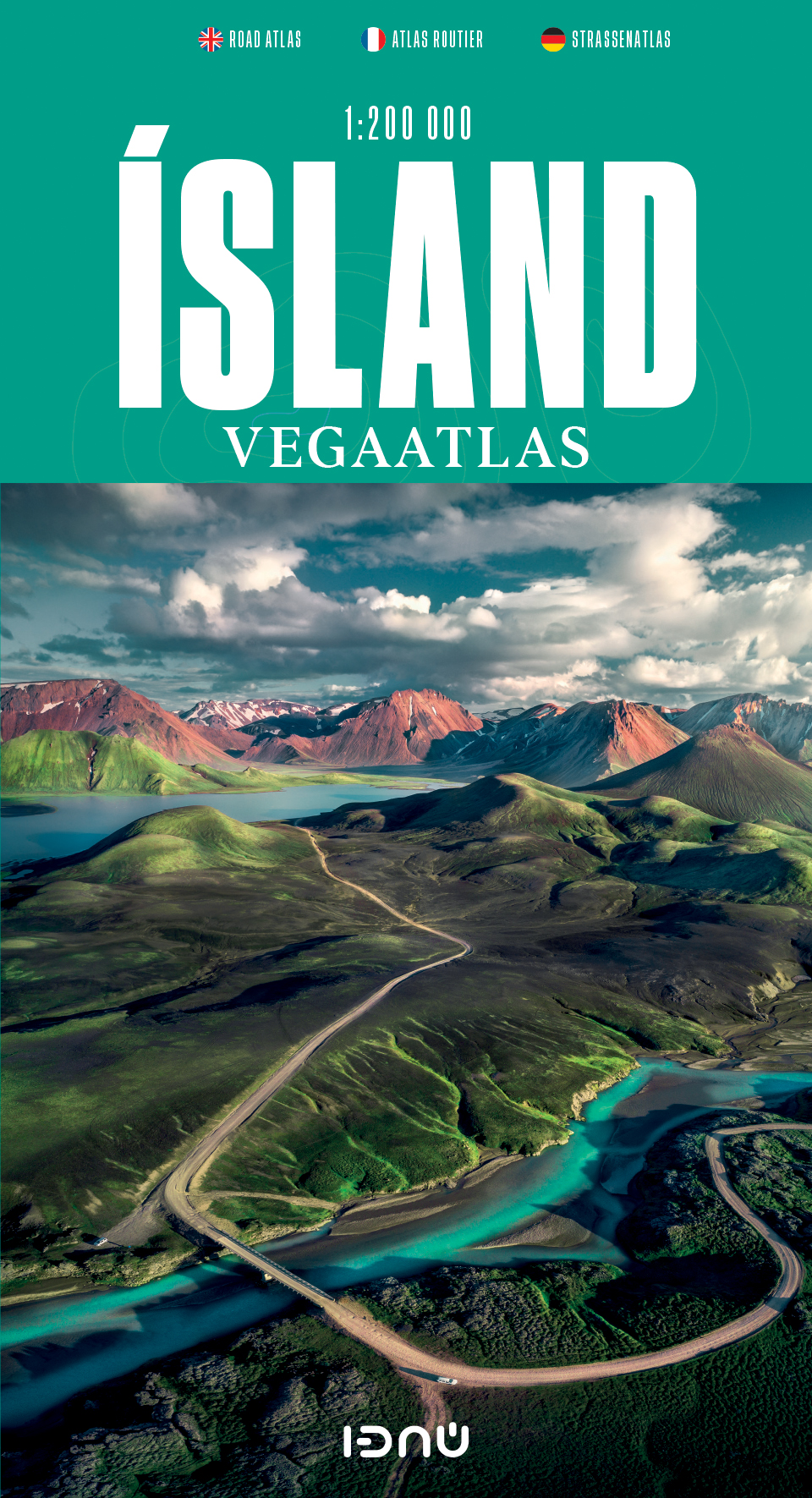
Gedetailleerde wegenatlas van IJsland, met duidelijke en gedetailleerde wegenkaarten van de topografische dienst op een schaal van 1:200.000. This road atlas is based on a map database on a scale of 1:250 000. In addition to 50 pages of road maps, the Road Atlas contains several theme maps covering accommodation, camping sites, museums, swimming pools and golf courses. There is also a comprehensive place-name index with over 15,500 entries. The format of the atlas makes it very easy for use in a car: it unfolds to a width of about 60 cm that gives an excellent overview of a large tract of land. The Road Atlas comes in a handy box. Scale: 1:200 000 Published: 2021 Size: 31 x 16 cm / Weight: 448 g / Pages: 86 Languages: Icelandic, English, German and French
€42,50
Bekijk product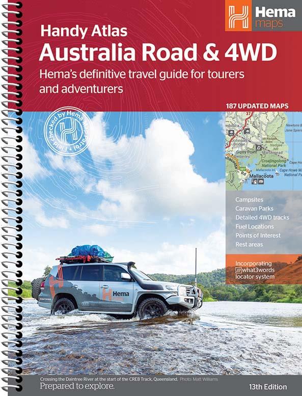
Wegenatlas Australie met toeristische informatie, uitgevoerd in handige spiraalbinding. Geweldige kaarten, goed leesbaar (beetje kleine letters wellicht voor sommigen) met veel toegevoegde waarde als het gaat om details als Nationale Parken, campsites, stranden en afstanden. De schaal varieert per bladzijde Featuring trusted Hema mapping for all of Australia, the Hema Road & 4WD Handy Atlas is the definitive travel guide for tourers and adventurers. Hema atlases feature more information useful to travellers, including 4WD tracks, campsites, caravan parks, rest areas, 24-hour fuel and points of interest. This edition in a handy size contains more mapping than ever before, which is enhanced by a striking new cartographic style that?s incredibly easy to read. Included in this is up-to-date mapping for Australia's biggest 4WD destinations: Cape York, Fraser Island, the Top End, the Kimberley, the Pilbara, Central Australia, High Country Victoria and the Flinders Ranges. A handy distance grid, national park guide, list of accredited information centres and a complete index are also included to assist with trip planning and navigation, making it the perfect tool for guiding tourers, campers, road trippers and off-roaders throughout Australia. Key Features Detailed 4WD tracks Fuel Points of interest National parks Campsites Caravan parks Rest areas Road distances Fully indexed
€29,95
Bekijk product
Wegenatlas op goede schaal met register / in spiraalbinding Mit landschaftlich schönen Strecken und Sehenswürdigkeiten, Übersichtskarte zum Ausklappen, Entfernungstabelle, Ortsregister, Citypläne, Europateil, Fernstraßenkarte, länderspezifische Verkehrsregelung, Spiralbindung. -Maßstab 1:200.000 -Übersichtskarte zum Ausklappen --7 MARCO POLO mark-it-sticker -Landschaftlich schöne Strecken und Sehenswürdigkeiten -Format 22,5 x 29,5 cm
€10,95
Bekijk product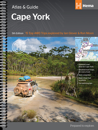
A4 formaat, verschillende schalen / spiraal uitvoering With detailed coverage of The Tip, the coast from Cairns to Cooktown, Rinyirru (Lakefield) National Park, the Peninsula Developmental Road, Old Telegraph Track, Torres Strait and the Savannah Way, it ensures you won’t miss the ‘must-see’ attractions, but it also describes some of the lesser known areas favoured by the experts. Whether you just want to make it to The Tip or are looking for a serious 4WD adventure, this informative book is an indispensable companion. The book features 15 4WD trips, explored and revised by travel journalist Ian Glover, with photography by Matt Williams. Each trip has a detailed map, plus all the information you need to plan the trip including trip grading, longest distance without fuel, permits and contact details. This brand new edition of Hema’s best-selling outdoor guidebook for discovering Cape York now features 22 atlas pages in a stunning new cartographic style and also incorporates content from the popular Cape York Travel & Adventure Guide by Ron and Viv Moon as well. Key Features: Featuring the top 15 4WD trips, including The Old Telegraph Track Detailed inset maps for every track Best campsites Trip planning tips Contains a detailed Road Atlas for Cape York, including detailed mapping for The Tip Maps show fuel, camping areas and rest areas New cartographic style with latest mapping, points of interest and facilities Mapping field-checked by the Hema Map Patrol
€45,95
Bekijk product