
Beantwoord enkele vragen, en binnen seconden geeft AI je een persoonlijk aankoopadvies op maat.
Beantwoord enkele vragen, en binnen seconden geeft AI je een persoonlijk aankoopadvies op maat.
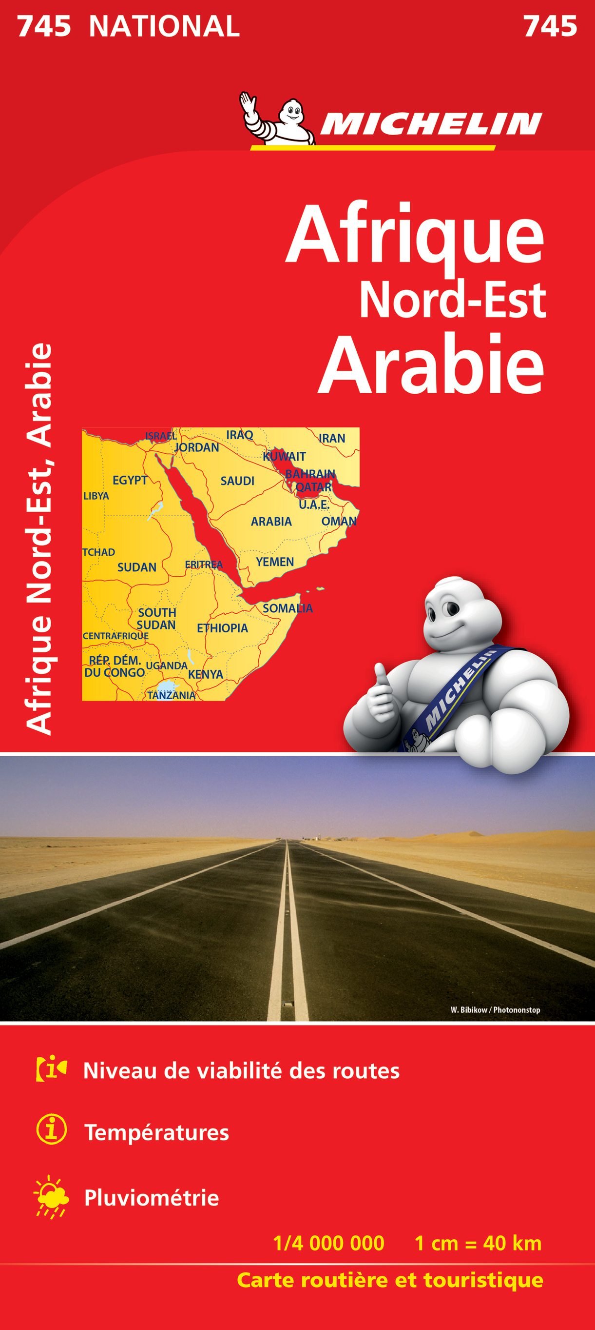
Zeer populaire kaart van een deel van Afrika voor overlanders en mensen die meerdere landen gaan bezoeken. Helder en overzichtelijk kaartbeeld met mooie kleuren. Schaduwgebruik laat de belangrijkste berggebieden zien. De wegen zijn geclassificeerd naar soort weg: dirt-road, asfaltweg, karrespoor etc. Daarnaast vind je op deze kaart spoorwegen. vliegvelden, tol, veerdiensten en bergpassen. Voor toeristen is handig dat nationale parken er goed en duidelijk opstaan. Gebied: Persische Golf - Nairobi - Kenia - Tobruk, Libië Congo, Egypte, Ethiopie, Irak, Israël, Jordanie, Libye, Oman, Qatar, Somalie, Sudan, Yemen
€12,95
Bekijk product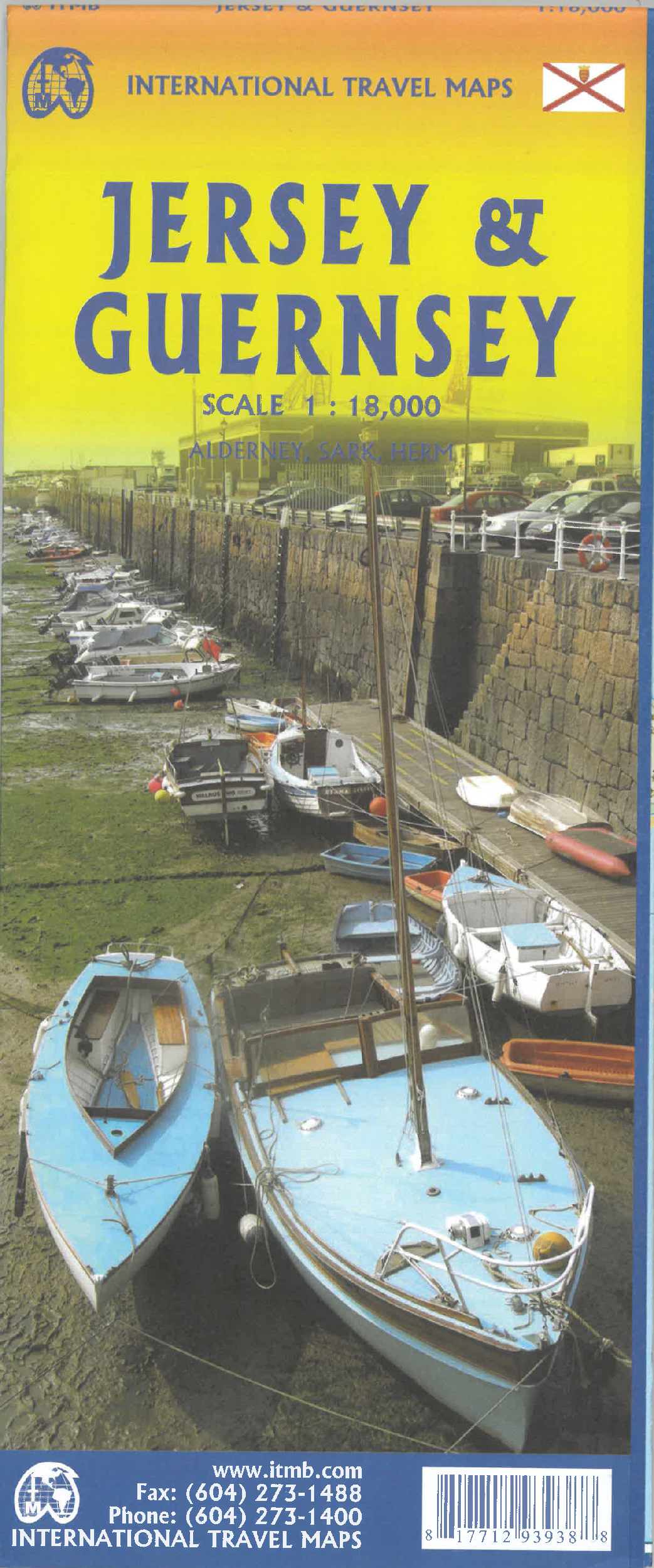
Goede detailkaart van alle kanaaleilanden. Het is zo gedetailleerd dat zelfs straatnamen er op staan. De kaart is ook nog eens geplastificeerd en daarmee scheur- en watervast. ITMB is pleased to re-introduce the Channel Islands map area after a lengthy hiatus of preparing new artwork. The first version of this part of Europe was licensed artwork by a local firm in Jersey, and upon running out of copies of the printed map, we opted to prepare fresh artwork of our own to continue this interesting corner of the continent to continue to be available. The islands, collectively known in English as the Channel Islands, are one of those anomalies that make Europe so attractive. They are part of Great Britain, but not part of the UK; hence, they are not part of the EU. They are self-governing entities ‘owned’ by the Queen in her role of being Duchess of Normandy. This is, of course, merely a hereditary situation, but the islands were the personal possessions of William the Conqueror in 1066, at the time he led Norman forces into Britain and won the Battle of Hastings. They remained his personal possessions and have been passed on from monarch to monarch for more than 950 years. Located just off the French coast, not too far from St. Malo, the islands were occupied by German forces during WW2, and are now readily available by ferry or airplane from both France and Britain. There are actually, five inhabited islands, of which Jersey and Guernsey are the largest. Alderney, Sark, and Herm make up the others. Ferries link the islands, and tourism is a major activity of the islands, along with banking. Most visitors arrive on Jersey, which on our map occupies an entire side. The airport is located near the western end of the island. Ferries arrive at St. Helier I’m very pleased that it is once again available.. Accommodations are plentiful and car rentals the best way to explore the island. The map shows all touristic attractions, roads, and rural restaurants/pubs. The reverse side is dominated by Guernsey, naturally, and its historic main town of St. Pete Port, but the shape of the island allowed us to include generous inset maps of Alderney and Sark, while including tiny Herm in the main map. This map has two covers: one showing Jersey and Guernsey, and the other noting Guernsey and Jersey, with two different pictures. And in the upper right corner, the flags of each island. This is one of those ‘must see before death’ touristic destinations and is well worth the visit. Legend Includes: Ferry route, Highway, Main Road, Secondary Road, Hotel, Restaurant, Port, Point of interest, Ruins / Ancient sites, Pub, Domestic Airport etc.
€14,50
Bekijk product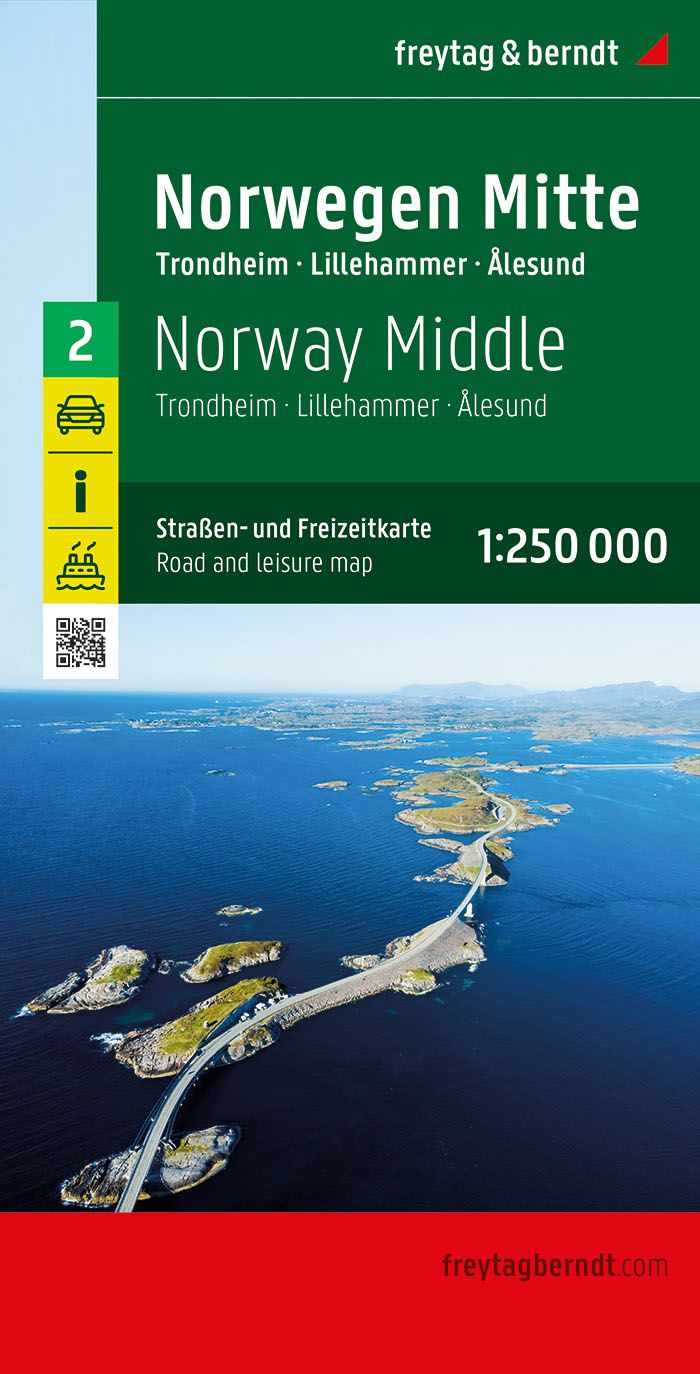
Goede duidelijke wegenkaart aan twee kanten bedrukt. Wel een grote lap kaart, maar daardoor bestrijkt het een groot gebied. Alle toeristische details staan er op, ook campings worden vermeld. De berijdbare wegen zijn goed weergeven, zowel de hoofdwegen als provinciale en lokale wegen; wegnummers worden vermeld. Afstanden tussen plaatsen zijn in kilometers op de kaart ingetekend, daarnaast worden ook op belangrijke plekken benzinepompen gemarkeerd. In het kaartbeeld wordt door middel van schaduw het reliëf weergegeven en soms enkele punten in het landschap met de daadwerkelijke hoogte. Provinciegrenzen zijn goed terug te vinden, nationale parken en reservaten ook. Met allerhande symbolen worden toeristische bezienswaardigheden weergegeven als monumenten, historisch belangrijke plekken en uitzichtpunten. In bepaalde plaatsen zijn hotels en campings te vinden, luchthavens, treinverbindingen en havens vindt u er ook op! Neben der übersichtlichen Gestaltung bietet die Straßenkarte Norwegen - Mitte (Trondheim - Lillehammer - Alesund) 1:250.000 zahlreiche Zusatzinformationen wie z.B. Straßenbeschaffenheit, Sehenswürdigkeiten, Campingplätze. Mit dem umfangreichen Ortsregister gelingt zudem eine rasche Orientierung. Details: Touristische Informationen, Fähren, Ortsregister mit Postleitzahlen, doppelseitig. freytag & berndt Autokarten sind für viele Länder und Regionen weltweit erhältlich.
€14,95
Bekijk product
Goede duidelijke wegenkaart aan twee kanten bedrukt. Wel een grote lap kaart, maar daardoor bestrijkt het een groot gebied. Alle toeristische details staan er op, ook campings worden vermeld. De berijdbare wegen zijn goed weergeven, zowel de hoofdwegen als provinciale en lokale wegen; wegnummers worden vermeld. Afstanden tussen plaatsen zijn in kilometers op de kaart ingetekend, daarnaast worden ook op belangrijke plekken benzinepompen gemarkeerd. In het kaartbeeld wordt door middel van schaduw het reliëf weergegeven en soms enkele punten in het landschap met de daadwerkelijke hoogte. Provinciegrenzen zijn goed terug te vinden, nationale parken en reservaten ook. Met allerhande symbolen worden toeristische bezienswaardigheden weergegeven als monumenten, historisch belangrijke plekken en uitzichtpunten. In bepaalde plaatsen zijn hotels en campings te vinden, luchthavens, treinverbindingen en havens vindt u er ook op! One of the titles in a series of detailed, indexed touring maps with plenty of tourist information. Southern Norway is shown at 1:250,000, with the two northern sheets at 1:400,000. Relief shading with spot heights indicates the terrain, with forested areas and natural features such as glaciers clearly marked. Road network includes private roads, toll routes, restrictions and winter closures, steep gradients, motorway service areas and accommodation, scenic routes, and intermediate driving distances on most roads. Railway network with stations and ferry connections are also marked.
€14,95
Bekijk product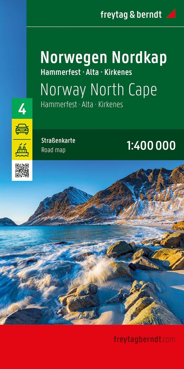
Goede duidelijke wegenkaart aan twee kanten bedrukt. Wel een grote lap kaart, maar daardoor bestrijkt het een groot gebied. Alle toeristische details staan er op, ook campings worden vermeld. De berijdbare wegen zijn goed weergeven, zowel de hoofdwegen als provinciale en lokale wegen; wegnummers worden vermeld. Afstanden tussen plaatsen zijn in kilometers op de kaart ingetekend, daarnaast worden ook op belangrijke plekken benzinepompen gemarkeerd. In het kaartbeeld wordt door middel van schaduw het reliëf weergegeven en soms enkele punten in het landschap met de daadwerkelijke hoogte. Provinciegrenzen zijn goed terug te vinden, nationale parken en reservaten ook. Met allerhande symbolen worden toeristische bezienswaardigheden weergegeven als monumenten, historisch belangrijke plekken en uitzichtpunten. In bepaalde plaatsen zijn hotels en campings te vinden, luchthavens, treinverbindingen en havens vindt u er ook op! This detailed road map of Norway North Cape is very suitable for planning and traveling around the country. The road network is well represented, both the main roads, provincial and local roads. Road numbers are also clearly stated. Distances between places are marked on the map in kilometers, and gas stations are also marked in important places. Shadow shows the relief and sometimes some points with the actual height. Province borders, national parks and reserves are easy to find. Symbols indicate the location of tourist sites, monuments, historically important places and viewpoints. In certain places you can find hotels and campsites, airports, train connections and ports.
€14,95
Bekijk product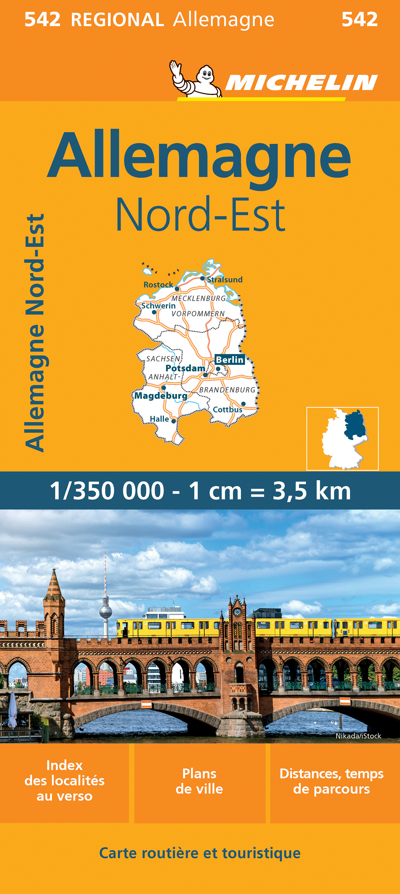
Zoals je van Michelin mag verwachten zijn het onmisbare overzichtskaarten van een uitstekende kwaliteit: een duidelijk en goed leesbaar kaartbeeld. Vrijwel alle berijdbare wegen staan er op ingetekend, in kleur verschillend voor grote en kleine wegen. Andere weginformatie omvat bijvoorbeeld kilometer-afstanden, tolwegen, helling-aanduiding, winterafsluitingen, tankstations maar ook de bekende groene routes: de mooiste wegen om te rijden. Daarnaast geeft de kaart toeristische informatie met symbolen weer: bezienswaardigheden als kastelen, kloosters, musea, maar ook campings (niet allemaal overigens). De kaart is voorzien van een 4-talige legenda. Toch hebben de makers door een beperkt gebruik van symbolen geen drukke kaart gemaakt. De kracht zit hem dan ook in de combinatie van meer dan voldoende informatie en goede leesbaarheid. Part of the orange regional series from Michelin, this Germany Northeast map shows this part of Germany in excellent detail. Primary & secondary road networks are clearly marked out with indications of the number of lanes, intermediate distances and various possible road obstacles or things you should know including steep hills, height limits, toll barriers, prohibited roads and roads subject to restrictions. The map also includes small insets with street plans of Berlin, Rostock, Magdeburgand Potsdam, showing road names, one way streets and various places of interest (tourist sights, hospitals, parking, railway stations, etc.). Scenic routes on the map are marked out in green and an extensive index of place names is included. The map also features: Administrative boundaries Railways, Airports and Ferry Services Important sights such as castles, ruins, and churches Driving Times and Distance Charts Road Safety Information A legend in multiple languages, including English Berlin, Magdeburg, Postdam, Rostock
€11,95
Bekijk product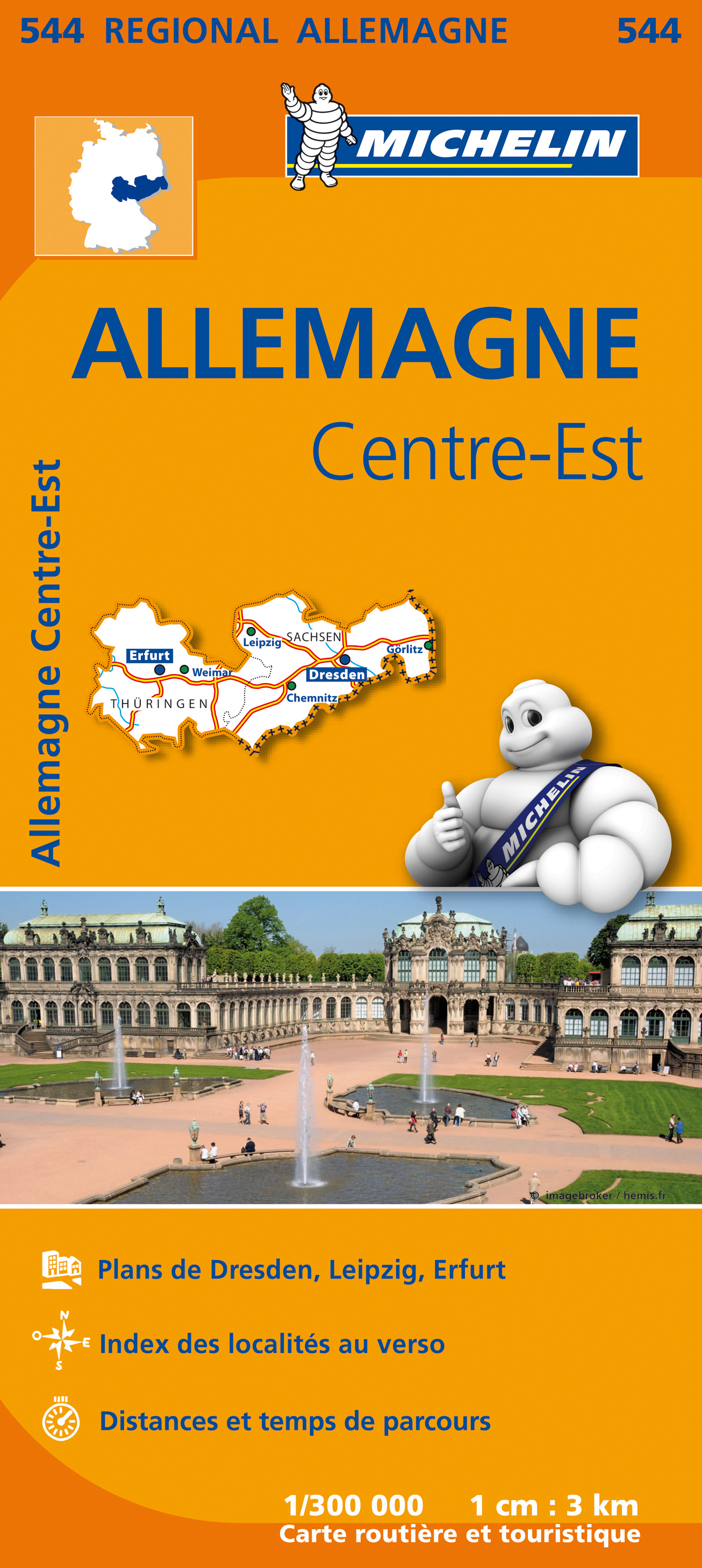
Zoals je van Michelin mag verwachten is deze kaart zeer overzichtelijk en heeft een duidelijk helder kaartbeeld. De kaart geeft uitgebreid toeristische informatie weer. Part of the orange regional series from Michelin, this Germany Mideast map shows this part of Germany in excellent detail. Primary & secondary road networks are clearly marked out with indications of the number of lanes, intermediate distances and various possible road obstacles or things you should know including steep hills, height limits, toll barriers, prohibited roads and roads subject to restrictions. The map also includes small insets with street plans of Dresden, Leipzig and Erfurt, showing road names, one way streets and various places of interest (tourist sights, hospitals, parking, railway stations, etc.). Scenic routes on the map are marked out in green and an extensive index of place names is included. The map also features: Administrative boundaries Railways, Airports and Ferry Services Important sights such as castles, ruins, and churches Driving Times and Distance Charts Road Safety Information A legend in multiple languages, including English Allemagne Centre, Allemagne Nord, Berlin, Brême, Cologne, Dresde, Hambourg, Leipzig
€11,95
Bekijk product
The border states between the USA and Mexico are of significant economic and travel importance, being some of the most traversed border crossings in the world. Touristically, northwestern Mexico appeals to desert lovers, with resort towns along the coast and arid ranch areas inland. The rail trip through the Copper Canyon is one of Mexico’s highlights and, yes, the hairless miniature shivering dog actually originates from Chihuahua. Printed double-sided on paper. Legend Includes: International and provincial borders, airports, roads by classifications, distances between points, gas stations, point of interests, archaeological sites, beaches, lighthouses, hotels, parks, museums, caves and other information.
€13,95
Bekijk product
De ANWB heeft een grote serie wegenkaarten van de belangrijkste landen en streken. Het zijn echte overzichtskaarten van vaak een wat groter gebied. Deze keuze zorgt er voor dat de schaal vrij grof is en bepaalde details zijn weggelaten. De kleurstelling is een beetje flets waardoor je niet altijd even makkelijk onderscheid kan maken tussen verschillende landschappen of natuurlijke aspecten. Ook het register ontbreekt. Het grote voordeel is vaak dat het gebied op de kaart overeenkomt met de vraag van klanten. Voor het plannen van een vakantie een prima kaart! Vergeleken met andere uitgevers van kaarten als Michelin, Freytag und Berndt of Reise KnowHow heeft de ANWB duidelijke keuzes gemaakt en gekozen voor een echte overzichtskaart. MET DE ANWB WEGENKAART, WEET JE WAAR JE STAAT! ANWB wegenkaarten zijn een begrip in het land. Dat laten de verkoopcijfers ook zien. Afgelopen decennia zijn meer dan 10 miljoen kaarten over de toonbank gegaan. De wegenkaarten zijn allemaal vernieuwd, met dikker karton voor de omslagen en papier dat minder makkelijk scheurt, zodat ze veelvuldig in- en uitgevouwen kunnen worden. Ze bieden een duidelijker overzicht van het wegennet en zijn nu nog compacter en handzamer. Met de gedetailleerde en nauwkeurige ANWB Wegenkaart Scandinavië/IJsland 6. Scandinavië zuid ga je goed voorbereid op autovakantie. Schaal van 1:1.000.000 (1 cm = 10 km).
€12,99
Bekijk product
Deze wegenkaart van British Columbia bestrijkt het gebied tussen Vancouver en Calgary, en is de perfecte toeristische kaart voor het verkennen van de regio Rocky Mountain. Alle wegen en spoorlijnen tussen de twee steden worden getoond, evenals campings en parken. This map covers the area between Vancouver and Calgary, and is the perfect tourist map for exploring the Rocky Mountain region. All roads and rail lines between the two cities are shown, as well as camp grounds, parks. Legend Includes: Points of interests, airports, RV and camping sites, wilderness camps, picnic areas, waterfalls, tourist information, museums, golf courses, gas stations, outdoor activities and other information. Folded paper, road and travel map in color. Scale 1:900,000. Distinguishes roads ranging from divided highways to other roads-4WD/dry weather. Legend includes railways, trails, ferry routes, glaciers, points of interest, international airports, domestic airports, museums, mountain peaks, camping/recreation sites, RV camping/recreation sites, hot springs, protected areas/National Parks, picnic areas, skiing areas, hospitals/treatment centres, gas stations, rafting areas, paddling areas, hiking, golf courses, viewpoints, mountain biking, diving, beaches, fishing areas, boat launches. Includes inset map of Downtown Victoria (1:20,000), Downtown Vancouver (1:13,000) and extensive place index.
€13,95
Bekijk product