
Beantwoord enkele vragen, en binnen seconden geeft AI je een persoonlijk aankoopadvies op maat.
Beantwoord enkele vragen, en binnen seconden geeft AI je een persoonlijk aankoopadvies op maat.
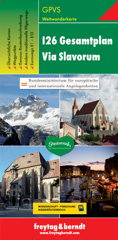
Dit is een overzichtskaart van de wandelkaart en/of pelgrimskaart voor de Via Slavorum, de internationale pelgrimsweg I26 die dwars door Midden-en Zuid-Europa voert: Van Krakau in Polen - Brno / Brünn in Tsjechië - Wenen, Mariazell, Graz, Klagefurt in Oostenrijk (Neder-Oostenrijk, Steiermark en Karinthie) - door het Save en Isonzodal in Slovenië - Venetië, Ravenna, Assisi, Rome in Italië. Let op: het betreft een overzichtskaart, het is geen wandelkaart. Alternatieve routes in Oostenrijk: a) Noordroute via Schöpfl, Mariazell, Seckau, St. Lambrecht en Gurk en b) Zuidroute via Perchtoldsdorf, Gutenstein, Semmering, Graz en St. Paul in het Lavantdal.
€14,95
Bekijk product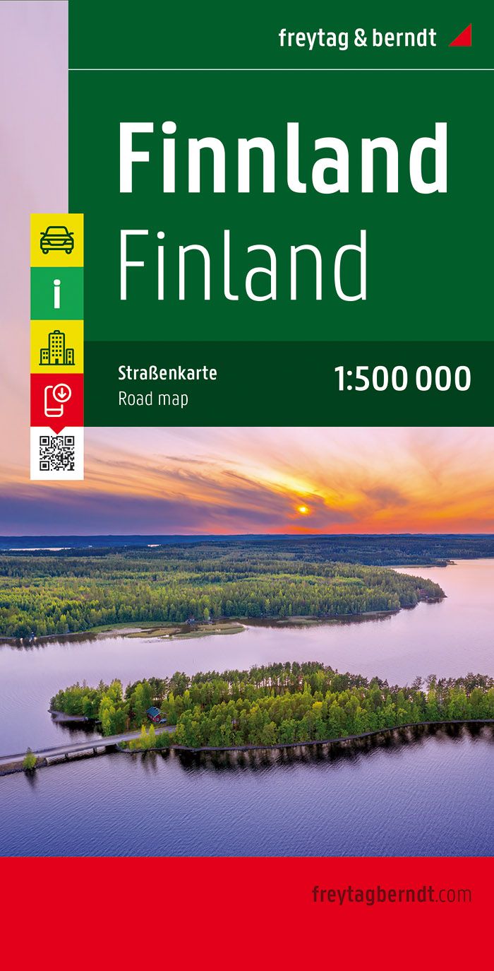
Uitstekende kaart van Finland. Met index, toeristische informatie en afstanden in kilometers. Dubbelzijdig. De berijdbare wegen zijn goed weergeven, zowel de hoofdwegen als provinciale en lokale wegen; wegnummers worden vermeld. Afstanden tussen plaatsen zijn in kilometers op de kaart ingetekend, daarnaast worden ook op belangrijke plekken benzinepompen gemarkeerd. In het kaartbeeld wordt door middel van schaduw het reliëf weergegeven en soms enkele punten in het landschap met de daadwerkelijke hoogte. Provinciegrenzen zijn goed terug te vinden, nationale parken en reservaten ook. Met allerhande symbolen worden toeristische bezienswaardigheden weergegeven als monumenten, historisch belangrijke plekken en uitzichtpunten. In bepaalde plaatsen zijn hotels en campings te vinden, luchthavens, treinverbindingen en havens vindt u er ook op!
€14,95
Bekijk product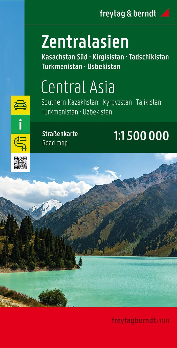
Gedetailleerde, eenzijdige landkaart van Centraal Azië, prima geschikt voor planning en rondtrekken . De berijdbare wegen zijn goed weergeven, zowel de hoofdwegen als provinciale en lokale wegen; wegnummers worden vermeld. Afstanden tussen plaatsen zijn in kilometers op de kaart ingetekend, daarnaast worden ook op belangrijke plekken benzinepompen gemarkeerd. In het kaartbeeld wordt door middel van schaduw het reliëf weergegeven en soms enkele punten in het landschap met de daadwerkelijke hoogte. Provinciegrenzen zijn goed terug te vinden, nationale parken en reservaten ook. Met allerhande symbolen worden toeristische bezienswaardigheden weergegeven als monumenten, historisch belangrijke plekken en uitzichtpunten. In bepaalde plaatsen zijn hotels en campings te vinden, luchthavens, treinverbindingen en havens vindt u er ook op!
€14,95
Bekijk product
Een degelijke wegenkaart van het noordoosten van de USA. (1:1.000.000) met aanduidingen van o.a. nationale parken, vliegveld, benzinepomp, dirt-roads. Als overzichtskaart goed te gebruiken. (1:1.000.000 Scale) including adjacent US states and bordering Canada . We started it wanting to do a map of just New England, but that will have to be a future title. By the shape of the USA, the New England States fill most of one side of the map, but New York City and Philadelphia are included as well as a goodly portion of New York State. The second side covers the rest of the state, plus all of New Jersey, Delaware, Maryland, Pennsylvania, and most of Ohio, West Virginia and the northern portion of Virginia. In terms of cities, Cincinnati is at the bottom left of the sheet and Richmond at the bottom right, with Detroit at upper left and Albany at upper right. The value of this map for visitors is that it covers a reasonably comprehensive portion of the USA, stretching as it does from northern Maine to south of Washington, DC. Thus, for someone driving from Canada or flying into Boston or NYC, this map offers the ability to travel using a sectional maps of a region, rather than having to rely on a variety of state maps for political entities that are geographically quite small (sorry, but they are). The map shows motorway interstates in blue and tries to show every interchange, main highways, and significant secondary roads that connect. Although place name inclusion is extensive, at this scale it is impossible to note all villages, especially in the vicinity of major urban areas. Parks, higher education institutes, ski areas, battlefields, airports, rail lines, and touristic attractions are all shown. Legend Includes: Roads by classification, Points of Interest, National Parks, Airports, Golf Courses, Beaches, Campsites, Waterfalls, Viewpoints, Churches, Surfing/Scuba Diving Spots, Fishing Spots, Hospitals, harbours/Ports, Lighthouses, Museums, Monuments, Caves, Mosques, Mountain Peaks, Botanic Gardens, Wildlife Sanctuary, Zoos, Sports Fields, and much more.
€13,95
Bekijk product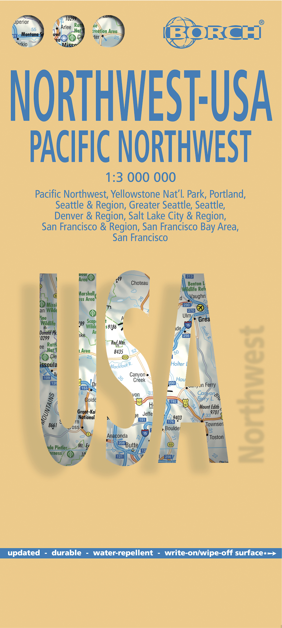
Mooie geplasticieerde kaart van het Noordwesten van de USA. Deze kaart biedt een goed overzicht van het land met detailkaarten. Our soft-laminated map of USA Northwest - USA 1 includes: Pacific Northwest 1:3 000 000, San Francisco 1:15 000, San Francisco Bay Area 1:400 000, San Francisco & Region 1:1 000 000, Seattle 1:13 000 and Greater Seattle 1:350 000, Seattle & Region 1:1 000 000, Portland 1:20 000, Denver & Region 1:1 000 000, Salt Lake City & Region 1:1 000 000, Yellowstone National Park 1:1 000 000, USA administrative & time zones, interesting statistics, conversion chart for temperatures, weights and measures, climate chart with temperatures, sunshine hours, precipitation and humidity and much more. The beautiful landscape of Oregon and Washington includes rugged coastline, mountain ranges, lakes, rivers, rich farmland and burgeoning wine country, as well as the magnificent cities of Portland and Seattle with their bustling cosmopolitan flair. While Seattle is renowned as the "San Francisco of the North", the states of Montana, Wyoming, Idaho, Colorado and Utah, dominated by the Rocky Mountains and their foothills, are home to some of America's most spectacular scenery. Yellowstone National Park - the world's largest supervolcano - is a highlight, with boiling geysers, mud volcanos, frozen lakes, deep pine forests, steep waterfalls, fossilized trees and an array of wildlife. Interesting cities include Salt Lake City - terminus of the Mormons great overland trek and Denver - a modern city that has retained its heritage as a wild frontier town.
€11,50
Bekijk product
Een degelijke overzichtskaart met aanduidingen van o.a. nationale parken, vliegveld, benzinepomp, dirt-roads.Waterproof. Double-sided, waterproof and tear-resistant map, extending east to just beyond 25°(the border of Libya and Egypt) , and roughly to 15° degrees (Bamako and Niamey) on its western half, and slightly further south on the other side (beyond Kano and Ndjamena). Elevation colouring indicates the topography, with landscape feature such as calderas, scarps and cliffs, lava fields, dunes, serir, marches, seasonal rivers, and salt pans. Oases and numerous wells/waterholes are also marked, most of them with names. International boundaries are shown with, where appropriate, border crossings. Road network includes rough tracks, and indicates location of petrol stations. Railways within the coastal areas of the covered countries are marked, and the map also shows small local airfields. A range of symbols indicate selected accommodation including rest houses and campsites, hospitals and medical facilities, parks and reserves, places of interest, etc. Oil wells and pipelines are also marked. Latitude and longitude lines are drawn at 5° intervals. The map is annotated with geographic and historic information and has an index of place names and a glossary of local geographic terms.
€13,95
Bekijk product
Mooie geplasticieerde kaart van het Brazilië. Deze kaart biedt een goed overzicht van het land met detailkaarten. Our soft-laminated map of Brazil in the 5th edition includes: Brazil 1:4 000 000, Fernando de Noronha Island 1:4 000 000, Brazil Amazon 1:8 000 000, Brasíiia 1:60 000, Manaus 1:15 000, Rio de Janeiro Center 1:15 000, Rio de Janeiro 1:175 000, Sao Paulo 1:20 000, Fortaleza 1:15 000, Natal 1:22 000, Recife 1:15 000, Salvador 1:14 000, Curitiba, Florianópolis, Porto Alegre each 1: 15 000, Brazil administrative & time zones; interesting statistics: conversion chart for temperatures, weights and measures; climate chart with temperatures, sunshine hours, precipitation and humidity; hotels, museums, markets and much more. The Federative Republic of Brazil is the fifth largest country in the world, the largest and most populous country and largest economy in South America and the seventh largest economy in the world. Bordered by the Atlantic Ocean to the east, the remaining border is formed by all the other South American countries except for Chile and Ecuador. Because Brazil was colonized by the Portuguese in 1500 it is the only South American country in which the official languag is Portoguese. Although it has a very large population (193 million) with urban centres concentrated primarily along the coast, there are vast uninhabited areas in the interior of the country. Both the Equator and the Tropic of Capricorn traverse Brazil. Due to the climate ranging from tropical to sub-tropical, the flora and fauna here are lush, colourful and plentiful. Natural resources are found in abundance. Besides the magnificent natural attractions the country has to offer "The Carnival de Brazil" and the endless beaches of Rio de Janeiro attract tourists the year round.
€11,50
Bekijk product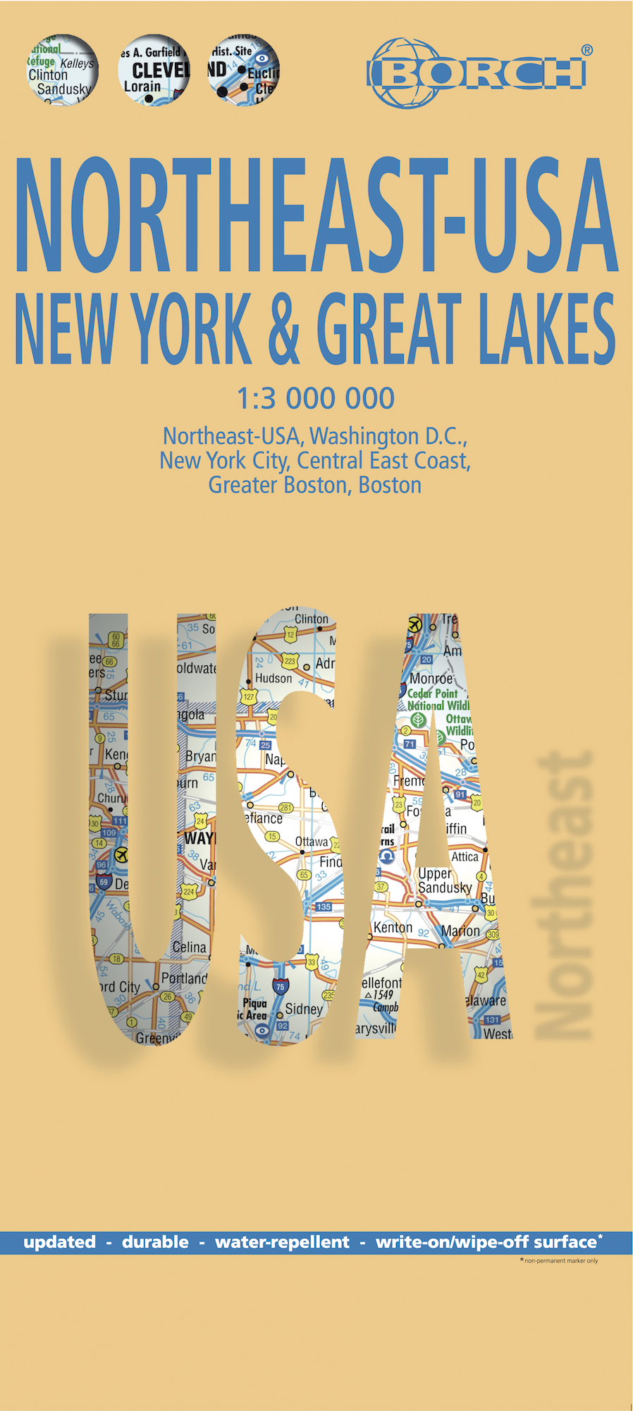
Mooie geplasticieerde kaart van het Noordoosten van de USA. Deze kaart biedt een goed overzicht van het land met detailkaarten. Our soft-laminated folded map of Northeast-USA - New York & Great Lakes shows: Northeast USA 1:3 000 000, Greater Boston 1:1 000 000, Central East Coast 1:1 000 000, Boston 1: 14 000, New York City 1:20 000, Washington DC 1:15 000, USA administrative & time zones. Borch maps are easy to fold, durable and water-repellent with a wipeable surface. Borch Maps show hotels, museums, monuments, markets, public transport, top sights and points of interest, useful statistics, conversion charts for temperatures, weights and measurements, climate charts showing temperatures, sunshine hours, precipitation and humidity, overview maps, time zones, and much more... From Philadelphia's Independence Park to Boston's Freedom Trail, New York's Federal Hall to Washington's Capitol Hill, from the Potomac to the "honeymooners' paradise" of Niagara Falls, New England and the mid-Atlantic States are brimming with history and tantalising beauty. Those who want to escape the frenetic pace of New York and Boston will be delighted by New England's old charm: the timeless beauty of "America's Rhine" (Hudson River Valley north of New York); the wildlife refuges of Long Island; the unique flavour of Cape Cod; the historic cities of Worcester and Providence. Washington D.C., the nation's magnificent capital, provides opportunity for fascinating excursions into the beautiful history-laden hinterland, including Manassas and Fredericksburg - former battlefields of the Civil War, Pennsylvania Dutch Country, the intriguing Appalachian ridges where the first Irish and German settlers established their roots and the enchanting scenery around Virginia's Tidewater region.
€11,50
Bekijk product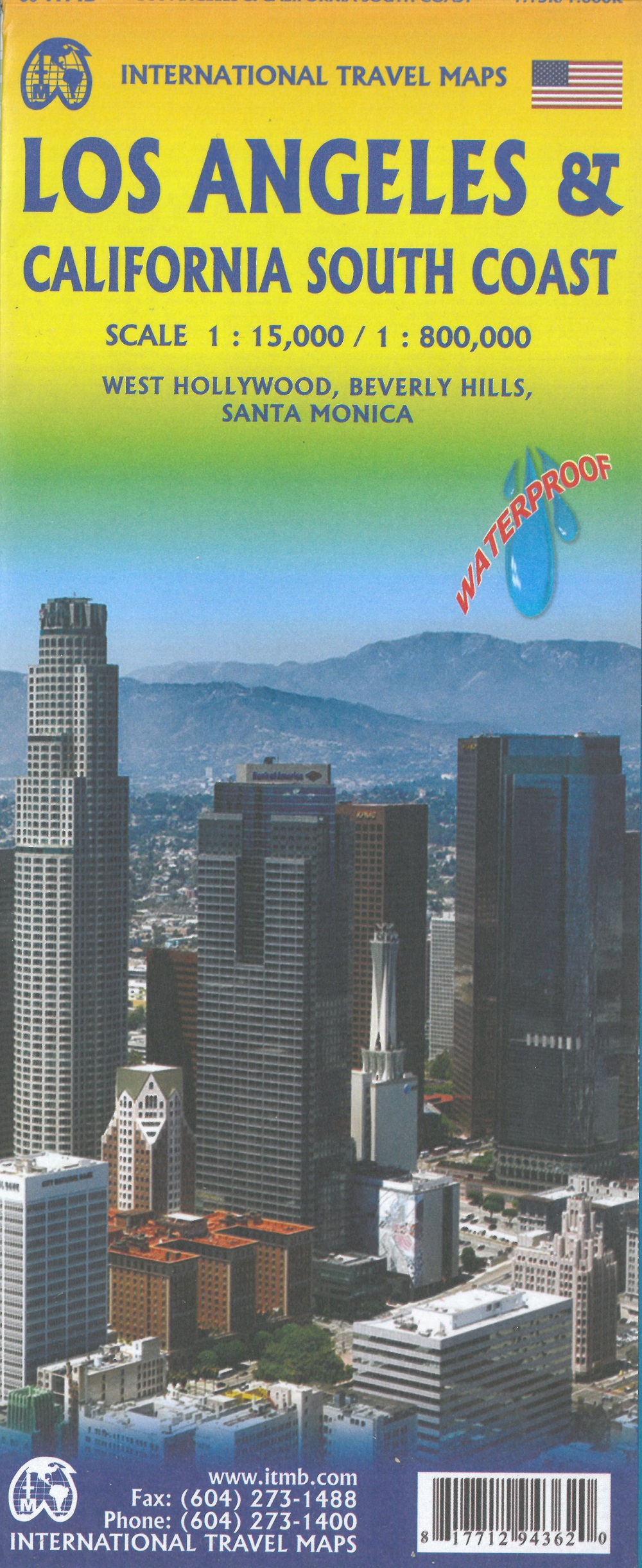
Dubbelzijdige kaart met aan de ene kant een plattegrond, 1 op 15.000, van Los Angeles. Aan de andere kant een degelijke kaart met aanduidingen van o.a. nationale parken, vliegveld, benzinepomp en campings van de zuidkust van Californië Als overzichtskaart goed te gebruiken. Legend Includes: Roads by classification, Accommodation, Museum, Church, Building, Points of tourist, Post Office, Police Station, School, Bicycle Route, Hiking Path, Road Barrier, Tourist Information, Hospital, Live Theatre, Cinema, Dept. Store, Bus Terminal, Pedestrian Street, Staircase, International Airport, State Park with Campsites, State Park without Campsites, Campsite, Wayside or Roadside Park, Rest Area, Lodge, Point of Interest, Domestic/Regional Airport, Information Center, Golf Course, Hot Spring, Port of Entry, Border Crossing, Gas Station, Service Area, University or College, Skiing, Lighthouse, Beach, Cave, and more.
€13,95
Bekijk product
Deze toeristische kaart van Lesbos op een schaal van 1:105.000 bevat hoogtelijnen, geeft toeristische informatie waaronder de aanduiding van campings en stranden, is voor GPS gebruik geschikt en is tweetalig ( Engels en Grieks). Op de achterkant staan stadsplattegronden.
€8,95
Bekijk product