
Beantwoord enkele vragen, en binnen seconden geeft AI je een persoonlijk aankoopadvies op maat.
Beantwoord enkele vragen, en binnen seconden geeft AI je een persoonlijk aankoopadvies op maat.
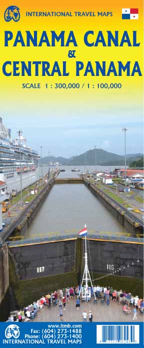
Een degelijke kaart met aanduidingen van o.a. nationale parken, vliegveld, benzinepomp, dirt-roads en kleine plattegrond van hoofdstad. Als overzichtskaart goed te gebruiken. Met name de natuurkundige apecten van het land of streek worden heel duidelijk weergegeven. One of the world’s great travel adventures is sailing through the Panama Canal, which we did last year (see cover photo). Panama itself is a large enough country that the canal, which is visited annually by millions of passengers, cannot be shown in meaningful detail. So, whether one is on board one of the many cruise ships squeezing into the Miraflores Locks or are a visitor ashore watching, the canal is a great attraction. The map is double-sided, with central Panama (the part most visited) filling side one. Side two is divided in half along the central fold. A very detailed map of Panama City fills the left side, and the first-ever map of the canal itself fills the other. This is a marvelously portrayed rendition of the most important canal in the world. Even at this scale, the locks themselves are thin lines on the sheet, but they’re there.
€13,95
Bekijk product
Een aangepaste versie van de Duitse provinciekaarten van Freytag & Berndt: duidelijk veel meer toegespitst op de toeristische aspecten van de streek. Deze bijzonder gedetailleerde Freytag & Berndt Wegenkaart van Allgäu is aan één kant geprint en heeft een schaal van 1:150.000. Op deze kaart staan o.a. campings, toeristische wegen en bezienwaardigheden aangegeven. Nu met een digitaal boekje en index - toegang tot alle informatie snel en gemakkelijk op uw mobiele telefoon! With the Allgau road map on a scale of 1:150,000, holidaymakers traveling by car, motorbike or caravan can easily find their way around. The dense road network is depicted precisely, distances and tourist destinations in the Allgau are shown on the map. Information about the Allgäu car map Scale 1:150,000 Tourist information Campsites and pitches Top Tips Location register with postal codes Downtown map Format: 124 x 86 cm The best car map for the Allgau Whether hiking, cycling, water sports or culture, the diverse leisure options make every visit to the Allgau an unforgettable experience. Drivers and motorcyclists particularly appreciate freytag & berndt's precise cartography for planning and on-site orientation. Caravan drivers and campers will of course find all campsites and pitches on the map. Top tips The 10 most important sights in the Allgau are briefly described on the back. These include the breathtaking Neuschwanstein Castle with its fairytale-like architecture, the idyllic Allgau Alps with numerous hiking opportunities, the picturesque Lake Constance , as well as the historic cities of Kempten and Memmingen , which fascinate with their rich history. This map is sheet 16 of the 17-part Germany 1:150,000 map series. Mit der Straßenkarte Allgäu im Maßstab 1:150.000 finden sich Urlauber die mit dem Auto, Motorrad oder Wohnwagen unterwegs sind bestens zurecht. Das dichte Straßennetz ist exakt abgebildet, Entfernungen und touristische Ausflugsziele im Allgäu sind in der Karte eingezeichnet. Informationen zur Autokarte AllgäuMaßstab 1:150.000Touristische InformationenCampingplätze und StellplätzeTop TipsOrtsregister mit PostleitzahlenInnenstadtplanFormat: 124 x 86 cmDie beste Autokarte für das Allgäu Ob Wandern, Radfahren, Wassersport oder Kultur die vielfältigen Freizeitmöglichkeiten machen jeden Besuch im Allgäu zu einem unvergesslichen Erlebnis. Auto- und Motorradfahrer schätzen die exakte Kartographie von freytag & berndt besonders für die Planung und Orientierung vor Ort. Wohnwagenfahrer und Camper finden in der Karte natürlich alle Campingplätze und Stellplätze. Top-Tips Im digitalen Beiheft sind die 10 wichtigsten Sehenswürdigkeiten im Allgäu kurz beschrieben. Dazu gehören das atemberaubende Schloss Neuschwanstein mit seiner märchenhaften Architektur, die idyllischen Allgäuer Alpen mit zahlreichen Wandermöglichkeiten, der malerische Bodensee, sowie die historischen Städte Kempten und Memmingen, die mit ihrer reichen Geschichte faszinieren. Diese Karte ist Blatt 16 der 17-teiligen Kartenserie Deutschland 1:150.000. Gedruckt in Österreich.
€14,95
Bekijk product
Goede wegenkaart van een deel van Portugal. Op betere schaal dan de hele landenkaart, met meer details. Met register. GPS toepasbaar. Town plans of Castle Branco, Leiria, Beja, Portalegre, Setubal, Santarem and Evora
€11,50
Bekijk product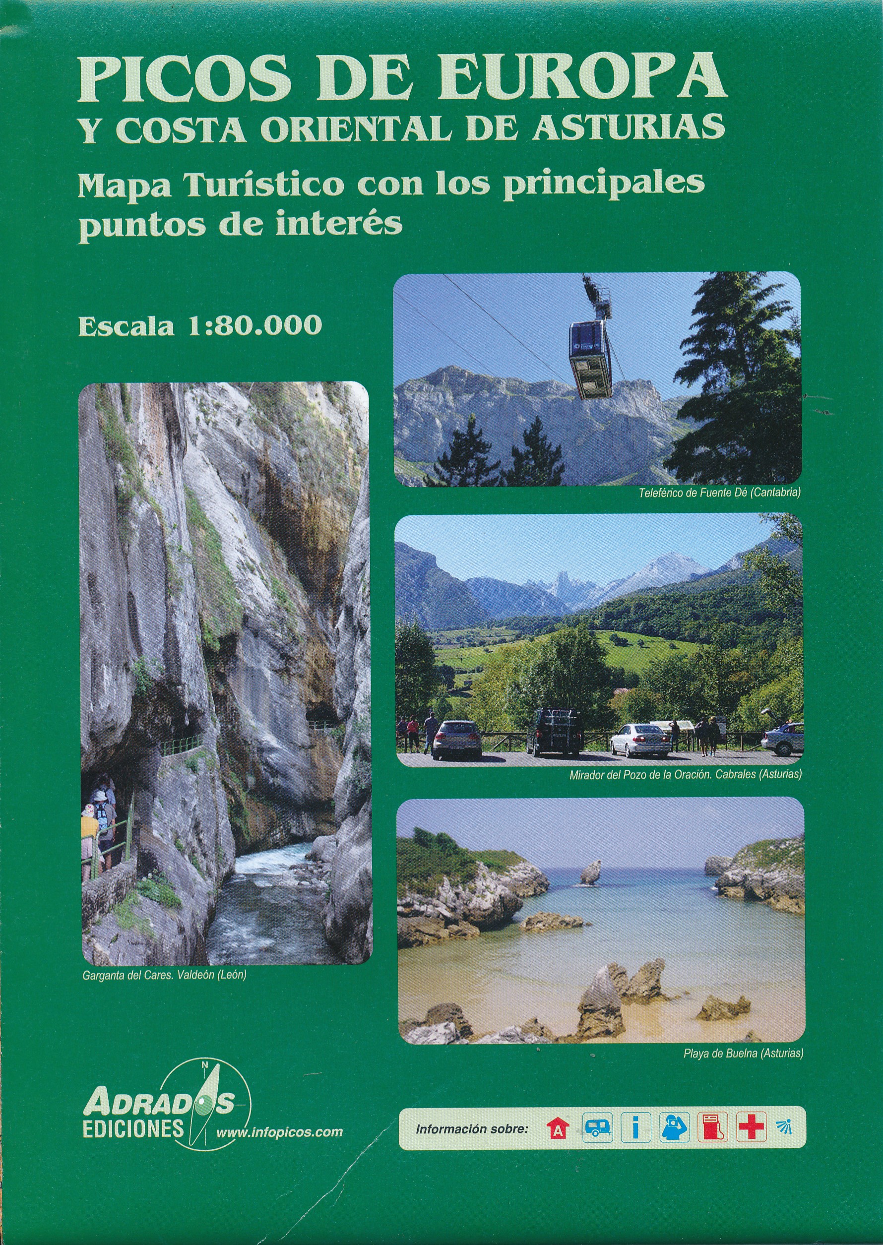
Overzichtskaart van de Picos de Europa en omstreken die als wegenkaart uitstekekend te gebruiken is. Om de wandelroutes in te plannen ook een prima kaart. Berghutten en campings staan ingetekend. Voor daadwerkelijk wandelen zijn de 25.000 kaarten duidelijk beter!
€11,95
Bekijk product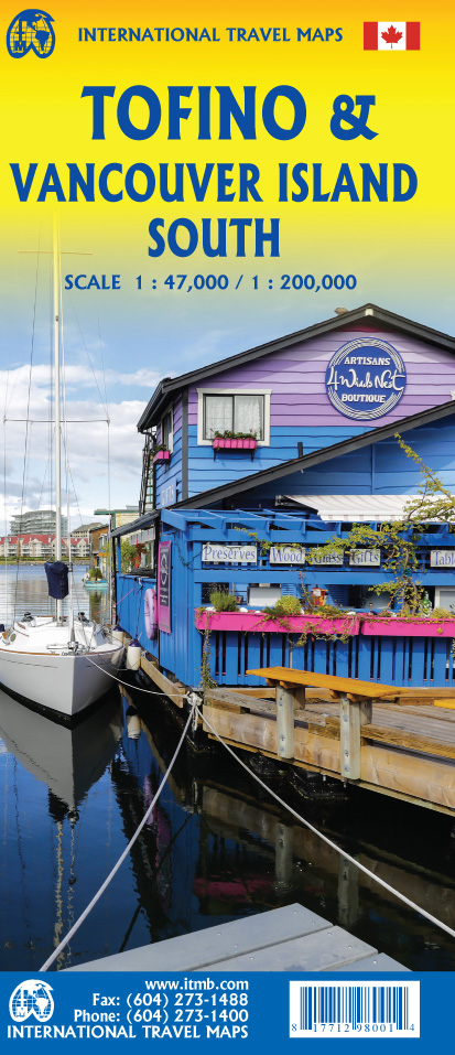
Vancouver Island is one of the marvels of tourism in Canada. It is, in fact, so big that it needs to be explored in sections to reach its full potential. Tofino is the westernmost town on the island and is home to the great Pacific fleet of fishing boats. It is also the westernmost leg of the ten thousand kilometer-long Trans-Canada Highway, and the beginning of the Trans-Canada National Hiking Trail. Side 1 concentrates on the immediate surrounds of Tofino, Seven-Mile Beach, and Kennedy Lake. Side 2 covers the southern half of the large island, from Victoria north to Courtenay, and includes the Broken Islands region off the west coast, the West Coast Hiking Trail, Cathedral Grove old growth forest, the Gulf Islands, and all the ferry connections with Vancouver and various islands, as well as all the Backroads logging roads that are the main way to explore the interior of wonderful Vancouver Island. Legend Includes: Roads by classification, Rivers and Lakes, National Park, Airports, Points of Interests, Highways, Main Roads, Zoos, Fishing, and much more...
€13,95
Bekijk product
The volcanic cone of Mount Fuji is Japan’s most popular touristic attraction. Located a short train ride west of Tokyo, Fuji attracts millions of visitors each year. Side 1 focuses on the mountain itself, showing rail connections, surrounding towns, roads on the lower slopes, hiking trails, and accommodations close to the summit. Side 2 shows the Kanto & Chubu Regions from Tokyo to Nagoya and north to Nigata. This is a brand new ITMB title. Legend Includes: Roads by classification, Rivers and Lakes, National Park, Airports, Points of Interests, Highways, Main Roads, Zoos, Fishing, and much more...
€13,95
Bekijk product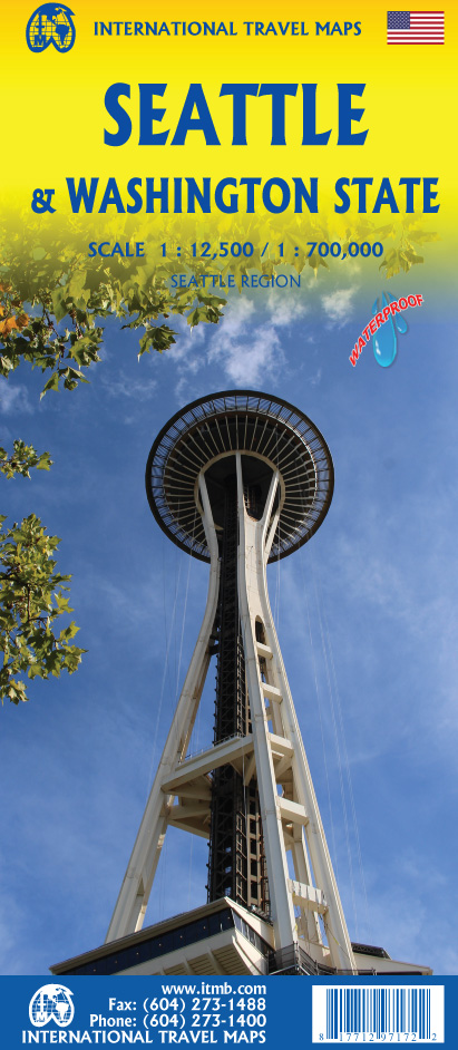
This is a new title for ITMB, in that it is the first time we have mapped the State of Washington. The actual area of the map includes Portland and northern Oregon and Vancouver and the border area with the USA. A small portion of Idaho is also shown. Wilderness campsites, parks such as Rainier, Olympic, and Baker, are shown. Seattle as a city, stretches far beyond the confines of a practical map in that it stretches from Everett to Tacoma. Our map covers from the University in the north to the Beacon Hill neighbourhood in the south and from the waterfront to Lake Washington. An inset map of the greater region is included. The rapid transit line is also included on the map and on the back cover. The reverse side of the sheet shows all the roads of Washington State in excellent Olympic, and Baker, state parks, touristic sites, beaches, ferry routes, native reserves, motorways, and even the ill-fated Hanford nuclear site are included. The map is printed on ITM waterproof paper for durability. Legend Includes: Roads by classification, Rivers and Lakes, National Park, Airports, Points of Interests, Mining, Highways, Main Roads, Zoos, Fishing, , and much more...
€13,95
Bekijk product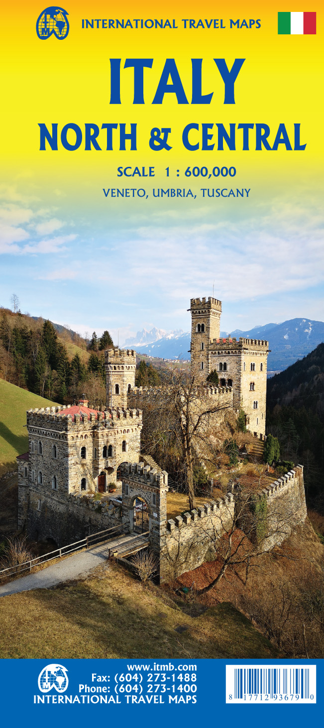
Italy is a very densely populated country, requiring sectional maps to portray its complex road/rail network in sufficient detail to make sense. This is a brand new title for ITMB, covering the central portion of the peninsula from Naples north to Florence on side one, and includes a large inset map of Sardinia. Side two covers the vast expanse of the north of the country, from the high alpine valleys of D’Aosta and Trentino to the plains of northern Italy and the coastal provinces of the Mediterranean and Adriatic coastlines. The immediate border areas of France and Switzerland are included, but the extensive plate name index covers most of those countries. Motorways (in blue) tend to be toll highways. Multi-lane highways (in magenta) and principal highways (in green) tend to be non-toll. The red lines are ordinary two-lane roadways, and tend to go through villages every kilometer or so and to follow mountainous contours. We spent a week in January, 2020, in the Rome to Naples to Montecassino triangle, and found the roads to be in good condition. We are now working on a companion map covering southern Italy, and on a detailed map of Sardinia to join our exiting maps of Sicily, Rome, and Venice. Legend Includes: Roads by classification, Rivers and Lakes, National Park, Airports, Points of Interests, Mining, Highways, Main Roads, Zoos, Fishing, , and much more...
€13,95
Bekijk product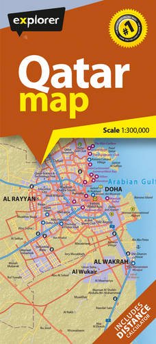
Explorer's latest Qatar map is the most current and comprehensive one to date. With pinpoint accuracy and an easy-to-read design, the whole of the country is covered along with an overview of its dynamic capital, Doha. Using the most up-to-date mapping resources and information available, the map shows all the cities, towns and villages, as well as key points of interest including hotels, airports, souks, historic areas and major highways. There is also a handy key and referencing system to help you find your way around, making this map the perfect travel accessory for holidaymakers, commuters and residents.
€13,95
Bekijk product
Handige kleine wegenkaart van Kreta. Crete is a big island, and a general map is necessary to plan your travel. But to better discover Crete you need to leave the car behind, and go hiking in the wild side of the island. There are here 7 hiking destinations with pictures, map and descriptions, to inspire you to explore the Cretan countryside. Crete R6 is a simple and inexpensive road map, ideal for short visits or planning long routes. Printed on plain paper.
€7,95
Bekijk product