
Beantwoord enkele vragen, en binnen seconden geeft AI je een persoonlijk aankoopadvies op maat.
Beantwoord enkele vragen, en binnen seconden geeft AI je een persoonlijk aankoopadvies op maat.
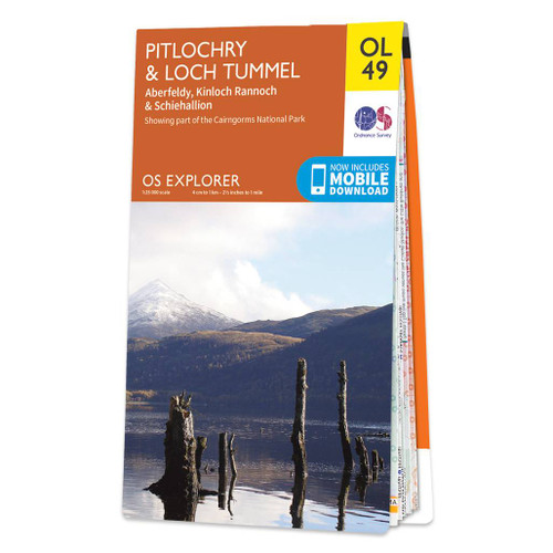
<p> <span style="font-size: 12px;">Met zijn 4cm voor 1 km (2 ½ cm voor 1 mijl) schaal, is de OS Explorer kaartenserie de ideale en meest gedetailleerde kaartenreeks voor mensen die graag outdoor-activiteiten zoals fietsen, wandelen, paardrijden, klimmen en watersporten.</span></p> <div> <span style="font-size: 12px;">Deze kaart is nog gedetailleerder dan de 'gewone' Landranger maps. Voor- en achterzijde bedrukt! Zeker op de moors en andere natuurgebieden van onschatbare waarden met echt alle aspecten van het landschap op de kaart ingetekend. Zeer goede detailkaart met topografische ondergrond. Hierop zijn toeristische symbolen van bezienswaardigheden ingetekend, daarnaast staan bijvoorbeeld campings en jeugdherbergen vermeld en - voor wandelaars het belangrijkst - alle right of way paden en Lange afstands Wandelpaden zijn er op te vinden. De ideale kaart voor het wandelen in Engeland, Wales of Schotland.</span></div> <div> </div> <div> <div> <strong>OS Explorer Map OL 49 shows Loch Tummel, eastern Loch Rannoch and the surrounding towns of Pitlochry, Aberfeldy and Kinloch Rannoch. Loch Tummel (and the Clunie Damn) are a popular area with vistors, with the magnificents 'Queens View' one of the most visited viewpoints in the region. This map replaces the previous OS Explorer map 386 for this area.</strong></div> <div> </div> </div> <div> </div> <div> These highly detailed maps show all the administrative boundaries, settlements as small as isolated farms, the road network down to unfenced roads and country tracks, and field boundaries (hedges and drystone walls) which make navigation across the countryside much easier. Steep gradients on roads are indicated. Various landmarks, e.g. powerlines, archaeological sites, windmills, churches and lighthouses are shown and additional graphics indicate natural terrain features such as cliffs, scree, mud and vegetation variations. The contour interval is 5 metres in the lower parts of the country and 10 metres in the uplands, and spot heights are marked. Each map covers an area of 30 x 20km (i.e. approx. 19 x 12 miles), with some double-sided maps covering more, as indicated in the individual descriptions. The maps are fully GPS compatible, with the National Grid shown at 1km intervals and latitude and longitude indicated by margin ticks at 1'.</div> <div> </div> <div> The Explorer series has replaced the earlier, green-cover Pathfinder maps. The Explorer series is now complete and covers all of England, Wales & Scotland. Some sheets for popular areas like the National Parks are still branded as Outdoor Leisure (OL) maps, but are now included in this series as the cartography is the same as that in the Explorer Maps. The Explorer maps offer a substantial improvement on the Pathfinder series, with greater use of colour, larger area per map, and stronger emphasis on information for ramblers and tourists.</div> <div> </div> <div> This series is ideal for walking and other outdoor pursuits and each map shows a large amount of information for ramblers and tourists. Public rights of way are shown (except in Scotland), together with other routes with public access: National Trails and Recreational Paths, permitted paths and bridleways, and selected cycle routes. Open access land created under the Countryside and Rights of Way Act 2000 is marked. Tourist information includes caravan and camp sites, Park & Ride locations, recreation/leisure/sport centres, museums, historic buildings, English Heritage and National Trust sites, rural pubs, etc. The map legend is in English only, except for the tourist information content which is also in French and German.</div>
€19,50
Bekijk product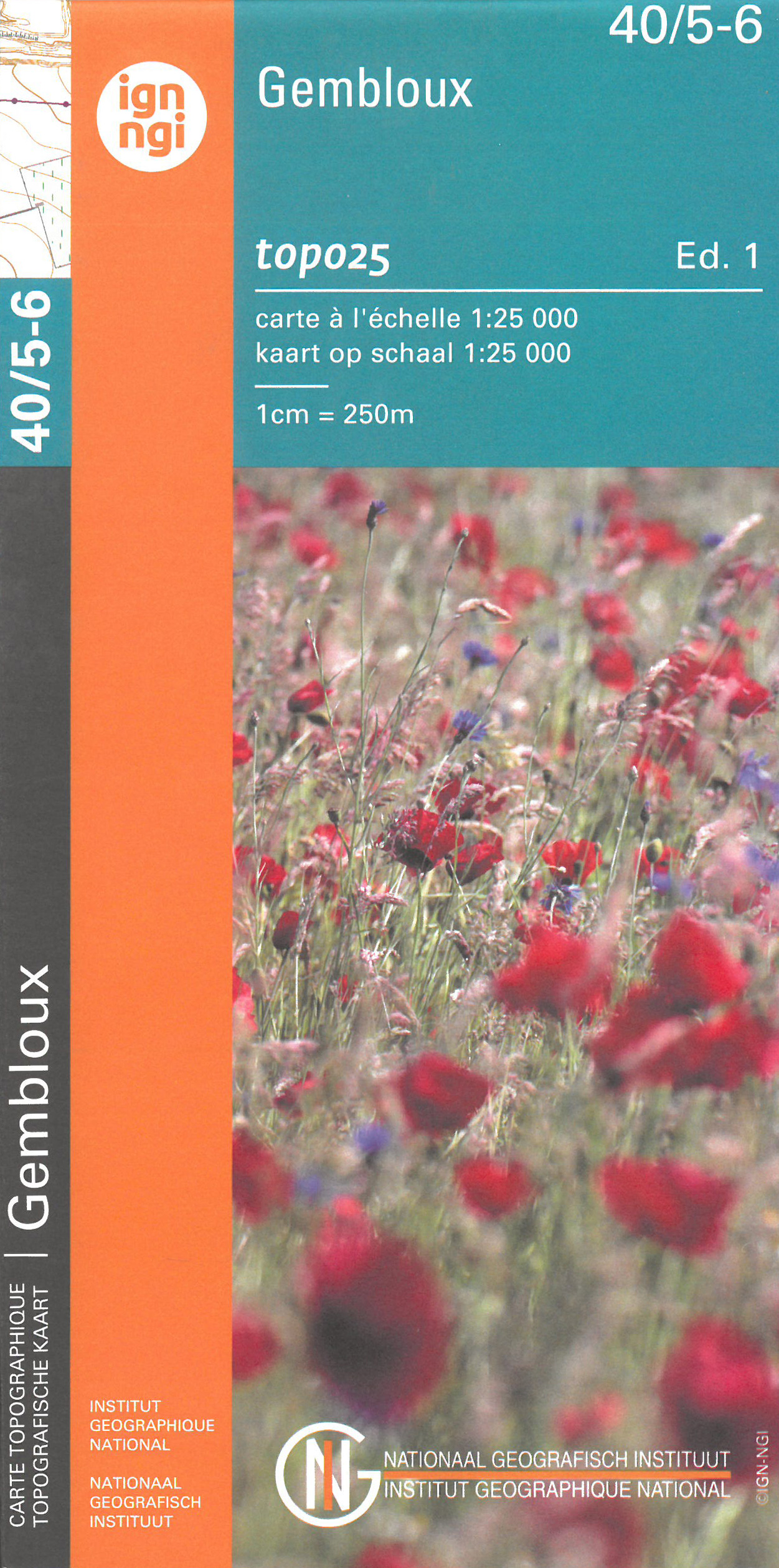
<div> Zeer gedetailleerde topografische kaart van een deel van Belgie. Deze kaart is bijzonder geschikt voor wandeltochten, bijvoorbeeld in het heuvelachtige gebied van de Ardennen. Wel moet u bedenken dat op deze kaarten wandelroutes als zodanig niet staan ingetekend. Voorzien van alle topografische details als hoogtelijnen, waterlopen, bosgebieden, paden en brandgangen. Hoogtelijnen maken het mogelijk de moeilijkheidsgraad van een wandeling in te schatten. Belangrijke oriëntatiepunten, zoals solitaire bomen, kapelletjes, hoogspanningslijnen, en vele andere, zijn ingetekend.</div> <div> </div> <div> De kaarten zijn voorzien van een gradenoverzicht en UTM grid en daardoor dus te gebruiken voor GPS tochten. Elk kaartblad bedekt een gebied van 160 km2. In grensgebieden zijn de gebieden buiten België in zwart/wit met minder detail uitgevoerd.</div> <div> </div> <div> Op het bijgevoegde overzicht kun u zien waar deze kaart gelegen is: eerst zoekt u het hoofdcijfer waarna de 2 laatste cijfers de daadwerkelijke positie weergeeft. De kaart met het hoofdcijfer is ingedeeld in 4 delen: 1-2 (noordwest), 3-4 (noordoost), 5-6 (zuidwest)en 7-8 (zuidoost).</div>
€10,95
Bekijk product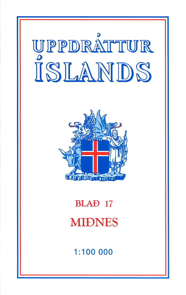
<p> </p> <div> Deze kaarten zijn niet direkt op voorraad. De levertijd is echter normaal gesproken slechts enkele dagen. Niet alle kaarten van deze serie zijn op dit moment beschikbaar. De kaarten die u niet kunt vinden vanuit het overzicht zijn niet leverbaar.</div> <div> </div> <div> Deze serie topografische kaarten van IJsland zijn goed gedetailleerd. Alle topografische details zijn er op terug te vinden. Dat de kaarteserie al uit de jaren 80 stamt, is voor IJsland niet zo'n probleem: er verandert niet zo veel. </div> <div> </div> <div> One of the maps in the topographic survey of Iceland at 1:100,000. The series was last revised in the early eighties. Contour interval is 20 meters. In addition to the usual features shown on survey mapping, the maps also include a large amount of information indicating the type of the terrain and land use (block or smooth surfaced lava, clay, boulders, sand and dunes, cultivated area, meadows, pastures, bogs, wetlands, etc.) and details not often found on maps: physicians' residences, parsonages, etc. Each map covers an area of 44 x 40 km / 27 x 25 miles. Margin ticks give latitude and longitude in steps of 6'. Map legend includes English.</div>
€24,95
Bekijk product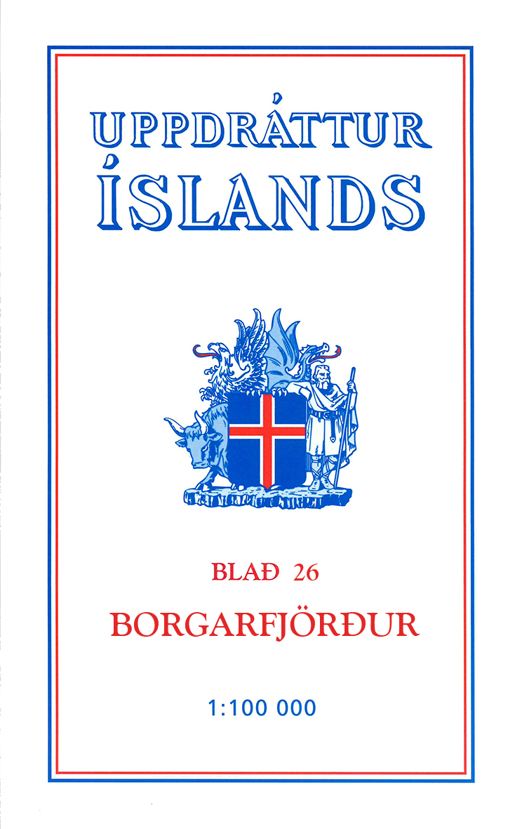
<p> </p> <div> Deze kaarten zijn niet direkt op voorraad. De levertijd is echter normaal gesproken slechts enkele dagen. Niet alle kaarten van deze serie zijn op dit moment beschikbaar. De kaarten die u niet kunt vinden vanuit het overzicht zijn niet leverbaar.</div> <div> </div> <div> Deze serie topografische kaarten van IJsland zijn goed gedetailleerd. Alle topografische details zijn er op terug te vinden. Dat de kaarteserie al uit de jaren 80 stamt, is voor IJsland niet zo'n probleem: er verandert niet zo veel. </div> <div> </div> <div> One of the maps in the topographic survey of Iceland at 1:100,000. The series was last revised in the early eighties. Contour interval is 20 meters. In addition to the usual features shown on survey mapping, the maps also include a large amount of information indicating the type of the terrain and land use (block or smooth surfaced lava, clay, boulders, sand and dunes, cultivated area, meadows, pastures, bogs, wetlands, etc.) and details not often found on maps: physicians' residences, parsonages, etc. Each map covers an area of 44 x 40 km / 27 x 25 miles. Margin ticks give latitude and longitude in steps of 6'. Map legend includes English.</div>
€24,95
Bekijk product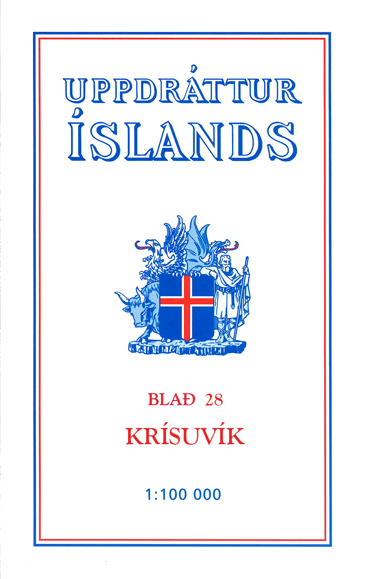
<p> </p> <div> Deze kaarten zijn niet direkt op voorraad. De levertijd is echter normaal gesproken slechts enkele dagen. Niet alle kaarten van deze serie zijn op dit moment beschikbaar. De kaarten die u niet kunt vinden vanuit het overzicht zijn niet leverbaar.</div> <div> </div> <div> Deze serie topografische kaarten van IJsland zijn goed gedetailleerd. Alle topografische details zijn er op terug te vinden. Dat de kaarteserie al uit de jaren 80 stamt, is voor IJsland niet zo'n probleem: er verandert niet zo veel. </div> <div> </div> <div> One of the maps in the topographic survey of Iceland at 1:100,000. The series was last revised in the early eighties. Contour interval is 20 meters. In addition to the usual features shown on survey mapping, the maps also include a large amount of information indicating the type of the terrain and land use (block or smooth surfaced lava, clay, boulders, sand and dunes, cultivated area, meadows, pastures, bogs, wetlands, etc.) and details not often found on maps: physicians' residences, parsonages, etc. Each map covers an area of 44 x 40 km / 27 x 25 miles. Margin ticks give latitude and longitude in steps of 6'. Map legend includes English.</div>
€24,95
Bekijk product
<p> <span style="font-family: 'Helvetica Neue', Helvetica, sans-serif, Arial;">Met zijn 4cm voor 1 km (2 ½ cm voor 1 mijl) schaal, is de OS Explorer kaartenserie de ideale en meest gedetailleerde kaartenreeks voor mensen die graag outdoor-activiteiten zoals fietsen, wandelen, paardrijden, klimmen en watersporten.</span></p> <div style="font-family: 'Helvetica Neue', Helvetica, sans-serif, Arial;"> Deze kaart is nog gedetailleerder dan de 'gewone' Landranger maps. Voor- en achterzijde bedrukt! Zeker op de moors en andere natuurgebieden van onschatbare waarden met echt alle aspecten van het landschap op de kaart ingetekend. Zeer goede detailkaart met topografische ondergrond. Hierop zijn toeristische symbolen van bezienswaardigheden ingetekend, daarnaast staan bijvoorbeeld campings en jeugdherbergen vermeld en - voor wandelaars het belangrijkst - alle right of way paden en Lange afstands Wandelpaden zijn er op te vinden. De ideale kaart voor het wandelen in Engeland, Wales of Schotland.</div> <div style="font-family: 'Helvetica Neue', Helvetica, sans-serif, Arial;"> </div> <div style="font-family: 'Helvetica Neue', Helvetica, sans-serif, Arial;"> These highly detailed maps show all the administrative boundaries, settlements as small as isolated farms, the road network down to unfenced roads and country tracks, and field boundaries (hedges and drystone walls) which make navigation across the countryside much easier. Steep gradients on roads are indicated. Various landmarks, e.g. powerlines, archaeological sites, windmills, churches and lighthouses are shown and additional graphics indicate natural terrain features such as cliffs, scree, mud and vegetation variations. The contour interval is 5 metres in the lower parts of the country and 10 metres in the uplands, and spot heights are marked. Each map covers an area of 30 x 20km (i.e. approx. 19 x 12 miles), with some double-sided maps covering more, as indicated in the individual descriptions. The maps are fully GPS compatible, with the National Grid shown at 1km intervals and latitude and longitude indicated by margin ticks at 1'.</div> <div style="font-family: 'Helvetica Neue', Helvetica, sans-serif, Arial;"> </div> <div style="font-family: 'Helvetica Neue', Helvetica, sans-serif, Arial;"> The Explorer series has replaced the earlier, green-cover Pathfinder maps. The Explorer series is now complete and covers all of England, Wales & Scotland. Some sheets for popular areas like the National Parks are still branded as Outdoor Leisure (OL) maps, but are now included in this series as the cartography is the same as that in the Explorer Maps. The Explorer maps offer a substantial improvement on the Pathfinder series, with greater use of colour, larger area per map, and stronger emphasis on information for ramblers and tourists.</div> <div style="font-family: 'Helvetica Neue', Helvetica, sans-serif, Arial;"> </div> <div style="font-family: 'Helvetica Neue', Helvetica, sans-serif, Arial;"> This series is ideal for walking and other outdoor pursuits and each map shows a large amount of information for ramblers and tourists. Public rights of way are shown (except in Scotland), together with other routes with public access: National Trails and Recreational Paths, permitted paths and bridleways, and selected cycle routes. Open access land created under the Countryside and Rights of Way Act 2000 is marked. Tourist information includes caravan and camp sites, Park & Ride locations, recreation/leisure/sport centres, museums, historic buildings, English Heritage and National Trust sites, rural pubs, etc. The map legend is in English only, except for the tourist information content which is also in French and German</div> <div style="font-family: 'Helvetica Neue', Helvetica, sans-serif, Arial;"> </div> <div style="font-family: 'Helvetica Neue', Helvetica, sans-serif, Arial;"> <div style="padding: 0px; margin: 0px; box-sizing: border-box; color: rgb(0, 0, 0);"> <strong style="padding: 0px; margin: 0px; box-sizing: border-box; line-height: inherit;">Ingetekende wandelroute</strong></div> <div style="padding: 0px; margin: 0px; box-sizing: border-box; color: rgb(0, 0, 0);"> Hadrian's Wall Path</div> </div> <p> </p>
€19,50
Bekijk product
<p> Met zijn 4cm voor 1 km (2 ½ cm voor 1 mijl) schaal, is de OS Explorer kaartenserie de ideale en meest gedetailleerde kaartenreeks voor mensen die graag outdoor-activiteiten zoals fietsen, wandelen, paardrijden, klimmen en watersporten.</p> <div> Deze kaart is nog gedetailleerder dan de 'gewone' Landranger maps. Voor- en achterzijde bedrukt! Zeker op de moors en andere natuurgebieden van onschatbare waarden met echt alle aspecten van het landschap op de kaart ingetekend. Zeer goede detailkaart met topografische ondergrond. Hierop zijn toeristische symbolen van bezienswaardigheden ingetekend, daarnaast staan bijvoorbeeld campings en jeugdherbergen vermeld en - voor wandelaars het belangrijkst - alle right of way paden en Lange afstands Wandelpaden zijn er op te vinden. De ideale kaart voor het wandelen in Engeland, Wales of Schotland.</div> <div> </div> <div> These highly detailed maps show all the administrative boundaries, settlements as small as isolated farms, the road network down to unfenced roads and country tracks, and field boundaries (hedges and drystone walls) which make navigation across the countryside much easier. Steep gradients on roads are indicated. Various landmarks, e.g. powerlines, archaeological sites, windmills, churches and lighthouses are shown and additional graphics indicate natural terrain features such as cliffs, scree, mud and vegetation variations. The contour interval is 5 metres in the lower parts of the country and 10 metres in the uplands, and spot heights are marked. Each map covers an area of 30 x 20km (i.e. approx. 19 x 12 miles), with some double-sided maps covering more, as indicated in the individual descriptions. The maps are fully GPS compatible, with the National Grid shown at 1km intervals and latitude and longitude indicated by margin ticks at 1'.</div> <div> </div> <div> The Explorer series has replaced the earlier, green-cover Pathfinder maps. The Explorer series is now complete and covers all of England, Wales & Scotland. Some sheets for popular areas like the National Parks are still branded as Outdoor Leisure (OL) maps, but are now included in this series as the cartography is the same as that in the Explorer Maps. The Explorer maps offer a substantial improvement on the Pathfinder series, with greater use of colour, larger area per map, and stronger emphasis on information for ramblers and tourists.</div> <div> </div> <div> This series is ideal for walking and other outdoor pursuits and each map shows a large amount of information for ramblers and tourists. Public rights of way are shown (except in Scotland), together with other routes with public access: National Trails and Recreational Paths, permitted paths and bridleways, and selected cycle routes. Open access land created under the Countryside and Rights of Way Act 2000 is marked. Tourist information includes caravan and camp sites, Park & Ride locations, recreation/leisure/sport centres, museums, historic buildings, English Heritage and National Trust sites, rural pubs, etc. The map legend is in English only, except for the tourist information content which is also in French and German</div>
€19,50
Bekijk product