
Beantwoord enkele vragen, en binnen seconden geeft AI je een persoonlijk aankoopadvies op maat.
Beantwoord enkele vragen, en binnen seconden geeft AI je een persoonlijk aankoopadvies op maat.
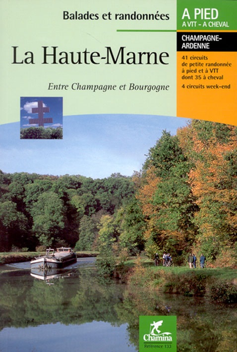
<p> Wandelgids met dagwandelingen - Duidelijk kaartmateriaal met ingetekende routes, de beschrijvingen zijn goed. Daarnaast ook praktische informatie.</p> <div> Entre les coteaux de Champagne et la plaine de Bourgogne, ce guide nous conduit sur des chemins secrets qui mènent vers des villages fleuris au coeur de vallons verdoyants.</div> <div> </div> <div> De chemins creux en plateaux, de forêts en étangs, ce pays de sources s'offre à qui prend le temps de s'émerveiller d'une orchidée, de suivre les grands oiseaux migrateurs, de flâner le long du canal, de découvrir la richesse de tout un patrimoine qui a marqué de son empreinte ce pays et l'âme de ses habitants.</div> <div> </div> <div> Le guide</div> <div> </div> <div> * 41 circuits de petite randonnée</div> <div> * Boucles de 1 h à 6 h 30 de marche, dont 41 praticables à VTT et 35 à cheval.</div> <div> * 4 circuits week-end, des randonnées en boucle de 2 à 4 jours.</div> <div> * Suggestions d'hébergements.</div> <div> * Des pages thématiques Pour tout savoir sur l'histoire, la faune et la flore, la forêt et le vignoble, les ressources du milieu aquatique, le patrimoine industriel et culturel.</div> <div> * Des infos pratiques</div> <div> </div>
€14,95
Bekijk product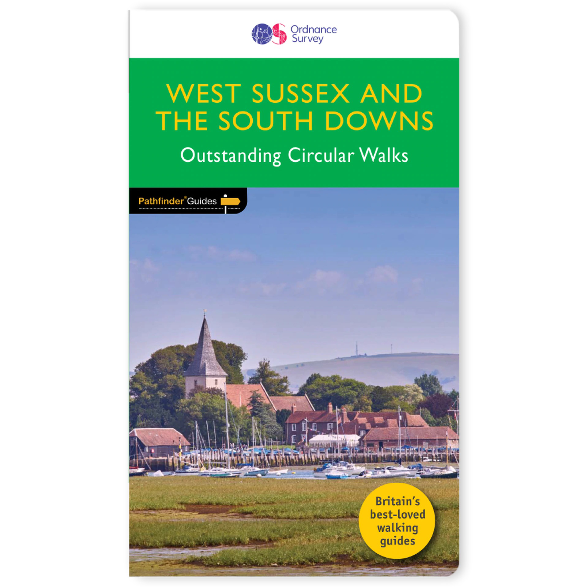
<p> Wandelgids van een deel van Engeland. Deze gids bevat 28 dagwandelingen, variërend van korte tochten tot pittige dagtochten. De bijbehorende kaarten zijn uitstekend: men heeft de topografische kaarten van Ordnance Survey gebruikt waarop de route is ingetekend. Daarnaast praktische informatie over de wandeling en wat beschrijvingen van het gebied.</p> <div> Containing 28 circular, graded walks that have all been created and tested by experienced walkers, this walking guidebook is ideal for both visitors and locals. The routes range from extended strolls to exhilarating hikes, so there is something for everyone. Each route includes a detailed description, the Ordnance Survey map for the route, GPS waypoints and key historical and landscape features to look for.</div> <div> </div> <div> The South Downs has some great opportunities for scenic, but not too challenging routes, including the South Downs Way. Walks in this book include one around Ardingly Reservoir, Devil's Dyke and the Arun Canal. Routes range from 5.6km (3.5 miles) to 17.6km (11 miles), an each is also graded by difficulty</div> <div> </div> <div> Pathfinder Guides are Britain’s best-loved walking guides. Printed with weather-resistant covers featuring durable rounded corners, they are the perfect companion for country walking throughout Britain.</div>
€18,50
Bekijk product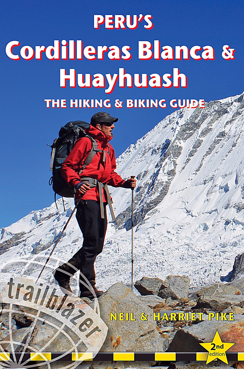
<div> The Cordilleras Blanca and Huayhuash boast some of the most spectacular scenery in the Andes, and some of the most accessible high altitude trekking and cycling in the world. Perfect pyramidal peaks, gargantuan ice falls and turquoise alpine lakes are all easily reached from Huaraz, the region's capital and centre of tourist comforts.</div> <div> </div> <div> This practical guide contains 50 detailed route maps and descriptions covering 20 hiking trails and 30 days of paved and dirt road cycle touring.</div> <div> Trekking – the classic treks: Huayhuash Circuit, Santa Cruz and Alpamayo Basecamp, as well as lesser known, wild walks in valleys which see few visitors. Ranging from easy day hikes to challenging routes of 10 days or more, all can be trekked independently or in guided groups.</div> <div> Cycling – includes the Huascarán Circuit, a loop of Peru's highest mountain, as well as four other multi-day rides and five day-cycles from Huaraz. Covers all the information cyclists need to pedal past glaciers on 6000m peaks or fly down 2500m descents from high passes.</div> <div> Mountain biking – includes two detailed downhill routes and information on organising guides to lead you through the labyrinth of exciting singletrack in the area.</div> <p> South America's top mountain adventure destination As mountain adventure destinations, the Cordilleras Blanca and Huayhuash in northern Peru are unrivalled in South America. The area boasts the most accessible high mountain trekking and biking in the world. Perfect pyramidal peaks, gargantuan ice falls and turquoise alpine lakes are all easily reached from Huaraz, the region's capital and centre of tourist comforts. Trekking 20 hiking trails Includes the classic treks: Huayhuash Circuit, Santa Cruz and Alpamayo Base Camp, as well as lesser known, wild walks in valleys which see few visitors. Ranging from easy day hikes to challenging routes of 10 days or more, all can be trekked independently or in guided groups. Cycling more than 30 days of paved and dirt routes Includes a loop of Peru s highest mountain - the Huascaran Circuit - as well as 6 other multi-day rides and 5 day cycles from Huaraz. Covers all the information cyclists need to pedal past glaciers on 6000m peaks or fly down 2500m descents from high passes. Mountain biking off road routes Includes two detailed downhill routes and information on organising guides to lead you through the labyrinth of exciting singletrack to be found in the area. Practical information planning your trip and getting to Peru City and town guides and maps Lima, Huaraz, Caraz, Carhuaz, Chavin, Chiquian, Pomabamba plus information on Yungay, Yanama, Chacas, Huari, San Marcos Minimum impact hiking and biking how to hike and cycle lightly in a fragile region Flora and fauna Language Spanish words and phrases 60 detailed route maps at 1:50,000 scale for main maps"</p>
€25,50
Bekijk product
<p> Uitstekende wandelgids met een groot aantal dagtochten in dal en hooggebergte. Met praktische informatie en beperkt kaartmateriaal! Wandelingen in verschillende zwaarte weergegeven in rood/blauw/zwart.</p> <p> <span style="font-family: Arial; line-height: 15px;">176 Seiten mit 103 Farbabbildungen, </span><span style="font-family: Arial; line-height: 15px;">50 Höhenprofile, 50 Wanderkärtchen im Maßstab 1:25.000 / 1:50.000, eine Übersichtskarte </span></p> <div> Das Reiseland Portugal ist vor allem bekannt für seine herrlichen Algarvestrände und die Kulturmetropolen Lissabon und Porto. Der Norden des Landes ist dagegen bis heute ein uriges und nahezu unentdecktes Naturparadies geblieben. Wanderer finden hier atemberaubend schöne Hügel- und Gebirgslandschaften, einsame Hochebenen und tief eingeschnittene Flusstäler. Darin eingebettet sind pittoreske Bergdörfer, auf den Hochweiden vermitteln die eindrucksvollen, aber gutmütigen Cachena-Langhornrinder einen Hauch von Wildwest. Der Rother Wanderführer »Portugal Nord« stellt 50 Touren zwischen Estrela und Minho vor.</div> <div> Der Wanderführer deckt ein recht großes Gebiet im Norden Portugals ab. Besonders schöne Wanderungen lassen sich in Portugals einzigem Nationalpark Peneda-Gerês ganz im Nordwesten, an der Grenze zu Galicien, oder in einem der fünf Naturparks der Region unternehmen. Die Tourenauswahl umfasst leichte bis anspruchsvolle Touren, kurze Spaziergänge wie auch Tageswanderungen. Dabei erschließen sich den Wanderern ganz unterschiedliche Landschaften: die Küstenregion rund um Esposende, einsame Hochflächen und anspruchsvolle Gebirgsregionen. Auch auf den höchsten Berg auf Portugals Festland, den 1.993 Meter hohen Torre in der Serra da Estrela, führen abwechslungsreiche Touren.</div> <p> </p> <div> Jeder Tourenvorschlag in diesem Wanderführer verfügt über eine zuverlässig Wegbeschreibung, einen Kartenausschnitt mit eingezeichnetem Wegverlauf und ein aussagekräftiges Höhenprofil. Eine farbige Schwierigkeitsbewertung erleichtert die Auswahl. Ein übersichtlicher Tourensteckbrief informiert bei jeder Tour übersichtlich über Anforderung, Ausgangspunkt, Einkehrmöglichkeiten, Varianten und vieles mehr. GPS-Tracks stehen zum Download bereit.</div>
€17,50
Bekijk product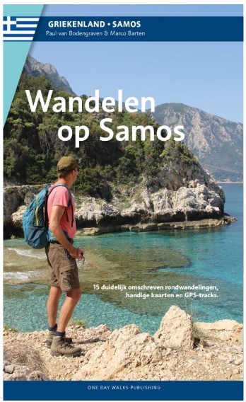
<div> 15 rondwandelingen op het Griekse eiland Samos</div> <div> </div> <div> Als er een prijs zou zijn voor de meest ongerepte en onbedorven vakantiebestemming in de Middellandse zee in de 21ste eeuw, dan zou Samos met zijn rust en natuurschoon beslist een goede kanshebber zijn voor de titel. Toerisme is hier weliswaar een belangrijke bron van inkomsten, maar het oogt en voelt toch als van ondergeschikt belang. Door het stelselmatig weren van hoogbouw, grote hotelketens en fastfood-restaurants hebben het eiland en zijn kustplaatsjes een eigen karakter en charme weten te behouden. Natuurlijk zijn er veel restaurants en toeristenaccommodaties, maar nergens is dat zo groots dat het storend wordt. De afwisselende landschappen oefenen grote aantrekkingskracht uit op wandelaars. Het eiland heeft zelf water en is daardoor groen en rijkelijk begroeid. Verschillende loofbossen wisselen af met dennenbossen en olijfboomgaarden. Terrassen met wijnbouw kleuren de berghellingen groen, je treft op meerdere plaatsen riviertjes en beekjes die tot laat in het seizoen water verspreiden over het eiland. Dat is de levensader voor de meest uiteenlopende bloemen, struiken en bomen. De culturele rijkdom, vooral uit de klassieke oudheid, maakt dat Samos naast al zijn wandelmogelijkheden ook een interessante bestemming is voor wie zijn of haar wandelschoenen eens een dagje wil laten staan. Gecombineerd met mooie stranden en gezellige dorpjes bezit Samos zo alle ingrediënten voor een geslaagde wandelvakantie. De wandelingen in deze gids zijn behoorlijk uitdagend, gezien de aanzienlijke hoogteverschillen die je moet overbruggen. Wie wil kan de bergen in, waar de hoogste toppen tot boven de 1.400 meter reiken. Maar er zijn ook wandelingen opgenomen die wat gemakkelijker te doen zijn, variërend van een paar uur tot een hele dag. Geniet van het goede Griekse leven en ontdek de mooiste plekken van Samos te voet.</div> <div> </div>
€15,95
Bekijk product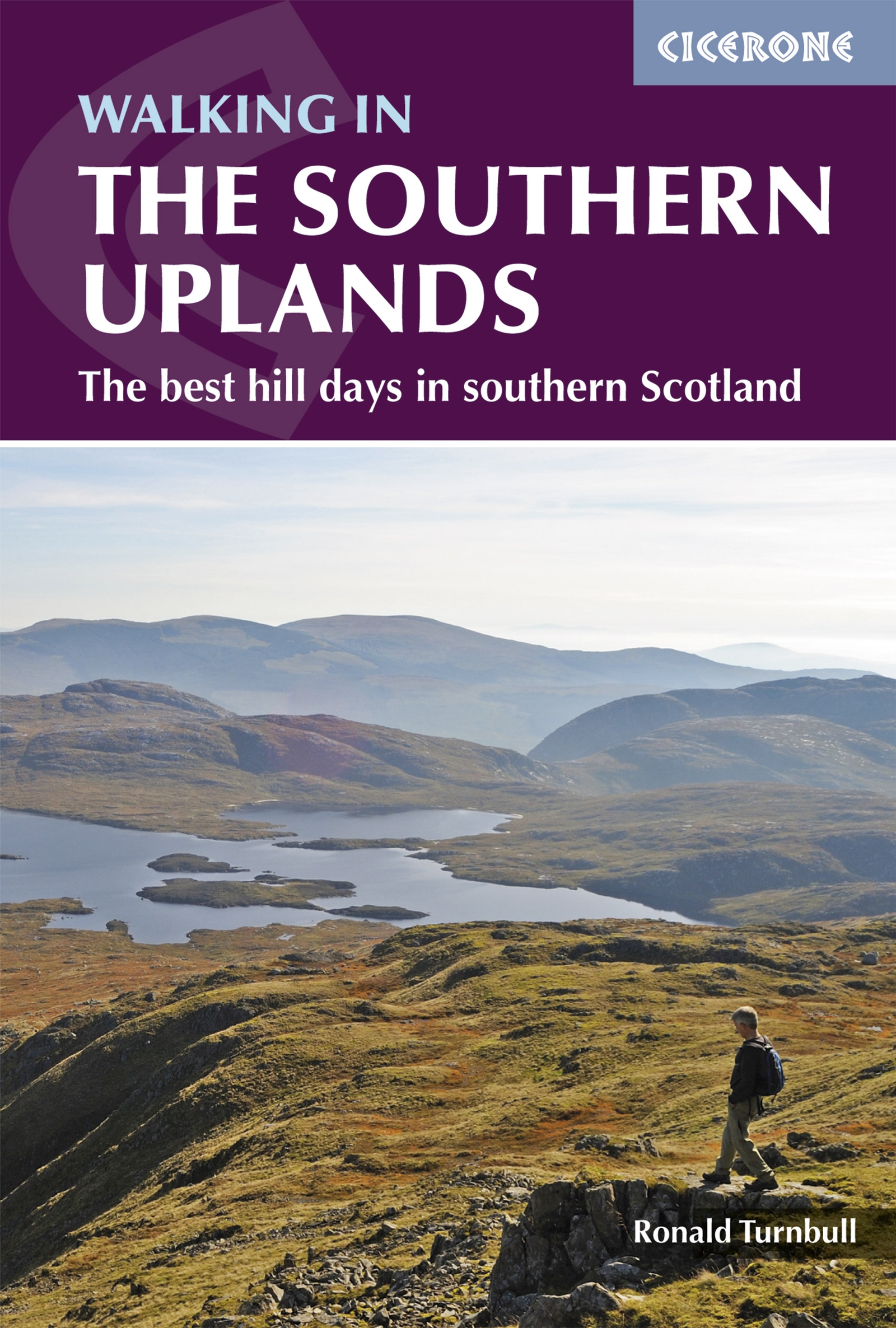
<div> This guidebook describes 44 routes and over 100 summits stretching across the Southern Uplands of Scotland, stretching south-west from Edinburgh to the English border, including the Galloway and Pentland Hills. The walks range between 2 and 29km, suitable for walkers of all abilities.</div> <div> </div> <div> The Scottish Southern Uplands is a range that is about as big as the English Pennines. It is wild hill country, with over 80 hills of 2000ft or more, and it boasts a real remoteness that is difficult to find elsewhere. All hillwalkers should experience these wonderfully characterful landscapes: green and gentle, but with hidden surprises and remote escapes.</div> <div> </div> <div> The routes are suitable from spring to autumn, and on winter days with good weather and snow conditions. Each route provides OS mapping, information on distance, ascent, time, maximum altitude and terrain, as well as details of any variants or shortcuts. With notes on points of interest along the way as well as on transport and accommodation, the guide gives all the information walkers need.</div>
€21,95
Bekijk product
<div> A guidebook to the Cumbria Way, a 73-mile long distance path through the heart of the English Lake District from Ulverston to Carlisle. The route is largely low-level, and accessible to new trekkers, but this guide offers alternative mountain days to climb some of the famous fells en route.</div> <div> </div> <div> The guide divides the route into 5 stages of between 12 and 16 miles, but there is plenty of opportunity to plan your itinerary for a more easy-going 7 to 8 days. The Lake District is a walkers paradise, and there is no better way to experience the fells, lakes and woodlands of the Lake District than by trekking through their midst. </div> <div> </div> <div> This guidebook also provides useful information for every stage, from accommodation to available facilities en route, as well as an annotated OS map and details on points of interest. The result is a guidebook that enhances a walk on the Cumbria Way, as well as providing the walker with the tools to complete the trek.</div> <div> </div> <div> <strong>Steden en Dorpen</strong></div> <div> Ulverston, Torver, Coniston, Elterwater, Great Langdale, Rosthwaite, Keswick, Bassenthwaite, Caldbeck, Dalston and Carlisle</div>
€20,95
Bekijk product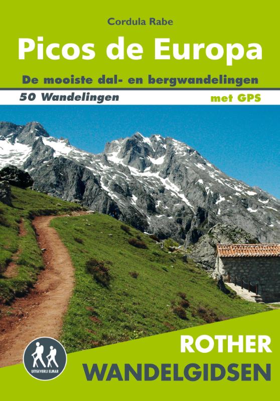
<div> De Rother Wandelgids Picos de Europa bevat 50 wandelingen voor zowel de beginnende als de ervaren wandelaar. Alle wandelingen zijn voorzien van betrouwbare routebeschrijvingen, gedetailleerde kaarten en hoogteprofielen.</div> <div> </div> <div> Met gratis downloadbare GPS Tracks.</div> <div> </div> <div> <div> Let op: er is enige verwarring omtrent het jaartal van deze Nederlandse wandelgidsen van uitgever Elmar. Dit is een vertaling van de Duitse uitgever Rother maar daarna NIET bijgewerkt. De datum die wij vermelden is het moment van vertaling; er zijn andere – meer recente jaartallen – in omloop maar dat is de datum van een nieuwe druk ZONDER aanpassingen. Wilt u de meest recente wandelgids van dit gebied van deze uitgever: kies dan de Duitstalige versie van uitgever Rother. Deze zijn recent en WEL bijgewerkt. </div> <div> </div> </div> <p> </p>
€19,99
Bekijk product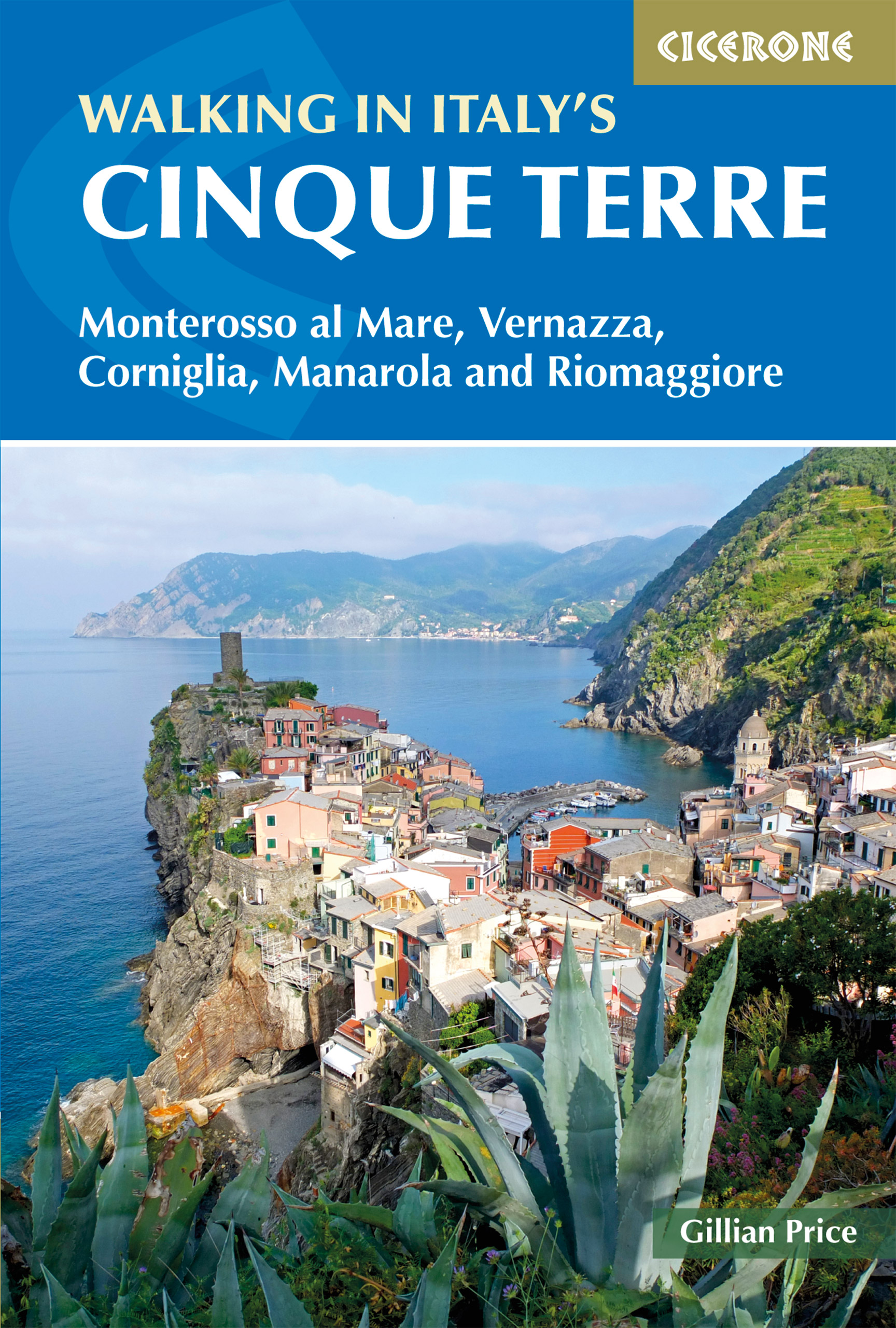
<p> Uitstekende wandelgids van de Cinque Terre. Goed beschreven met veel praktische informatie om de routes te kunnen lopen, inclusief redelijke kaarten.</p> <p> This guidebook presents 16 graded walks exploring the world-famous Cinque Terre villages of Liguria in Italy. Suitable for beginners and experienced walkers, routes take in the villages of Monterosso, Vernazza, Manarola, Corniglia, Riomaggiore, as well as neighbouring Levanto, Campiglia and Porto Venere. It describes the most popular pathways as well as less trodden routes to hidden gems.<br /> <br /> Route descriptions and maps for each walk are accompanied by information on how to get around by public transport (train, ferry and bus), with background notes on history, culture, wildlife and flora, and suggestions on where to sleep and what to eat. In short, everything you could possibly need to get the most out of a holiday in this unique corner of the Italian Riviera.<br /> <br /> One of the best loved places in Italy, the Cinque Terre are UNESCO World Heritage listed, a string of centuries old fishing villages where colourful houses, terraced fields and vineyards perch on plunging cliffs above a breathtaking coastline. It's a paradise for walkers and food-lovers, who can follow age-old routes constructed by the locals and sample the seafood specialities on offer at harbour-side trattorias.</p> <p> Steden en Dorpen</p> <p> The Cinque Terre villages of Monterosso, Vernazza, Manarola, Corniglia, Riomaggiore, as well as neighbouring Levanto, Campiglia and Porto Venere.</p>
€20,95
Bekijk product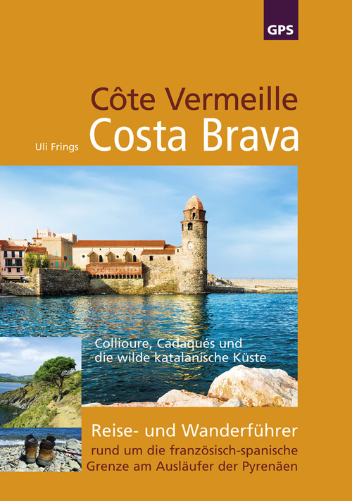
<p> Die Côte Vermeille ist in Deutschland ungefähr so unbekannt wie die Costa Brava verrufen. Wer denkt bei Costa Brava nicht an Bettenburgen und Partymeilen? Dabei bietet der nördliche Teil der katalanischen Küste vom Künstlerort Collioure bis zum Naturschutzgebiet Cap de Creus Küstenwanderungen, die zu den schönsten am Mittelmeer gehören. Das Gebiet rund um die heutige französisch-spanische Grenze ist ein landschaftlich und kulturell spannendes Reiseziel und vor allem außerhalb der Hochsaison eine fantastische Wanderregion</p> <ul> <li> Dieser grenzüberschreitende Reiseführer bietet</li> <li> 22 ausführlich beschriebene Wandertouren mit Detailkarte und Höhenprofil, inklusive 12 Etappen Küstenwanderung von Argelès-sur-Mer bis Roses. Alle Wanderungen mit GPS-Track zum Download.</li> <li> Viele Tipps und Adressen rund um die wilde Küste Kataloniens.</li> <li> Kunst: Salvador Dalí und Henri Matisse, Surrealismus und Fauvismus.o</li> <li> Geschichte: Spanischer Bürgerkrieg, Flüchtlingsdrama in Argelès-sur-Mer und die katalanische Unabhängigkeitsbewegung.</li> <li> Memorial: Walter-Benjamin-Weg, letzte Chance zur Flucht vor den Nazis. Erster deutschsprachiger Wanderführer mit Karte und ausführlicher Beschreibung der wunderschönen Bergwanderung über die küstennahen Pyrenäen.</li> <li> Ökologie: Die Ausgangspunkte der Wanderungen sind gut mit Bahn, Bus oder Schiff erreichbar.</li> </ul>
€16,95
Bekijk product