
Beantwoord enkele vragen, en binnen seconden geeft AI je een persoonlijk aankoopadvies op maat.
Beantwoord enkele vragen, en binnen seconden geeft AI je een persoonlijk aankoopadvies op maat.

<p> Uitstekende wandelgids met een groot aantal dagtochten in dal en hooggebergte. Met praktische informatie en beperkt kaartmateriaal! Wandelingen in verschillende zwaarte weergegeven in rood/blauw/zwart.</p> <ul> <li> detaillierte Wanderkarten</li> <li> aussagekräftige Höhenprofile</li> <li> GPS-Tracks zum Download</li> </ul> <div> Grün und rund geschliffen liegen die Nockberge im Norden von Kärnten. Wegen ihrer sanften, meist rundlichen Form werden die Gipfel »Nocken«, also Kuppen, genannt. Blühende Almböden, duftende Lärchen- und Zirbenwälder, plätschernde Bergbäche und klare Seen bilden eine einzigartige Landschaft. Der Rother Wanderführer »Nockberge« stellt die 56 schönsten Touren im Biosphärenpark Nockberge, den Gurktaler Alpen und dem Maltatal vor.</div> <div> </div> <div> Zwischen den malerischen Kärntner Seen und dem Alpenhauptkamm liegt das stille Wandergebiet Nockberge, das als Geheimtipp für Genießer und Entdecker gilt. Die wunderbaren Wanderregionen Maltatal und Liesertal, die Turracher Höhe, die Nockalmstraße,die Gurktaler Alpen und die Norische Region liegen in diesem Gebiet und versprechen viel Genuss. Die Höhenunterschiede in den Nockbergen sind meist eher gering, die Natur und die Ausblicke dabei fantastisch. Neben zahlreichen Genusswanderungen stellt der Wanderführer auch zwei Touren auf die beiden attraktiven Dreitausender Schneewinkelspitze und Hafner vor – wahre Highlights für geübtere Bergsteiger.</div> <div> </div> <div> Alle Touren in diesem Wanderführer werden vorgestellt mit ausführlichen, zuverlässigen Wegbeschreibungen, detaillierten Kartenausschnitten mit Routeneintrag und aussagekräftigen Höhenprofilen. Zudem stehen zu jeder Tour GPS-Daten zum Download von der Website des Rother Bergverlags bereit. Damit ist der Rother Wanderführer der ideale Begleiter für einen ausgedehnten Wanderurlaub in den Nockbergen.</div>
€18,50
Bekijk product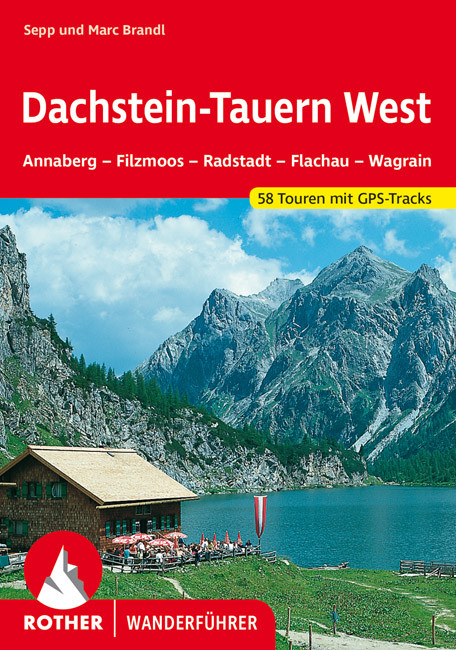
<p> Uitstekende wandelgids met een groot aantal dagtochten in dal en hooggebergte. Met praktische informatie en beperkt kaartmateriaal! Wandelingen in verschillende zwaarte weergegeven in rood/blauw/zwart.</p> <div> <div> Das Wandergebiet des Rother Wanderführer »Dachstein-Tauern West« umfasst vor allem die bekannten Tourismusregionen »Salzburger Sportwelt« und »Sportregion Dachstein-West«. Das Gebiet erstreckt sich von St. Johann im Pongau bis an den Westrand der Steiermark und vom Tennengebirge bzw. Dachstein bis zum Tauerntunnel. Neben Dachsteingebirge, Gosaukamm und Radstädter Tauern lernt der Bergfreund auch die Südostecke des Tennengebirges, die Salzburger Schieferalpen und die westlichen Ausläufer der Schladminger Tauern kennen.</div> <div> </div> <div> Der Wanderer wird mit diesem Führer in eine Gebirgslandschaft voller Kontraste und ursprünglicher Schönheit begleitet. Spektakuläre Aussichtspunkte am Fuß der Dachstein-Südwand und der Bischofsmütze werden ebenso vorgestellt wie beschauliche Almen und märchenhafte Biotope. In den Radstädter Tauern mit ihren verwitterten, zauberhaften Kalkburgen und kristallklaren Bergseen warten stille und einsame Winkel auf ihre Entdeckung.</div> <div> </div> <div> Der Autor Sepp Brandl, ein hervorragender Kenner dieser Gebirgsgegend, stellt insgesamt 58 Touren vor – von der einfachen Hütten- und Almwanderung bis zur anspruchsvolleren Hochgebirgsroute. Auf manchen Unternehmungen sind Bergbahnen und Wandertaxis beim Aufstieg behilflich, die meisten kommen aber ohne sie aus.</div> <div> </div> <div> Tourensteckbriefe, ausführliche Wegbeschreibungen, aussagekräftige Höhenprofile und detaillierte Kartenausschnitte im Maßstab 1:50.000 und 1:75.000 machen alle Tourenvorschläge leicht und sicher nachvollziehbar. Ergänzend stehen GPS-Tracks zum Download bereit. Die farbige Schwierigkeitsbewertung erleichtert die Auswahl der Ziele und zahlreiche Farbfotos wecken die Wanderlust.</div> </div> <p> </p>
€18,50
Bekijk product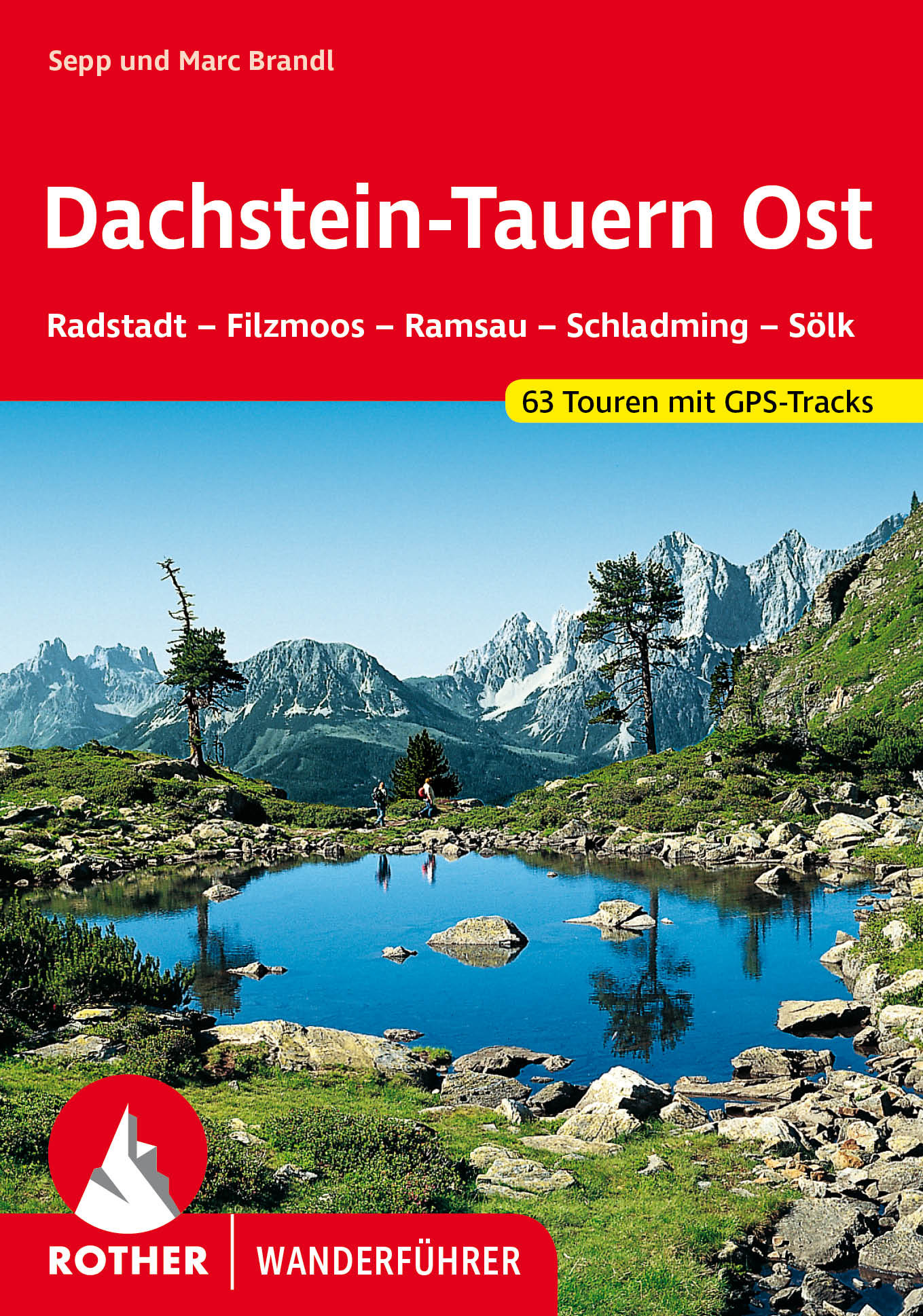
<p> Uitstekende wandelgids met een groot aantal dagtochten in dal en hooggebergte. Met praktische informatie en beperkt kaartmateriaal! Wandelingen in verschillende zwaarte weergegeven in rood/blauw/zwart.</p> <p> Eine Welt der Kontraste: Schroffe, leuchtende Kalkwände über grünen Wiesenmatten und Wäldern sowie Gletscher in der Hochregion zeichnen das Dachsteingebirge aus. Ihm gegenüber liegen die Schladminger Tauern mit klaren Bergseen und rauschenden Wasserfällen. Wer einmal die Schönheit dieser kontrastreichen Bergwelt erlebt hat, wird begeistert sein. 63 ausgewählte Wanderungen stellt der Rother Wanderführer »Dachstein-Tauern Ost« vor - von der genussvollen Tal- und Hüttenwanderung bis zur anspruchsvolleren Hochgebirgsroute. Ein Highlight ist die mehrtägige Durchquerung der Schladminger Tauern.Jeder Tourenvorschlag verfügt über eine zuverlässige Wegbeschreibung, einen Kartenausschnitt mit eingetragenem Routenverlauf und ein aussagekräftiges Höhenprofil. Zudem stehen GPS-Tracks zum Download von der Internetseite des Rother Bergverlag bereit.Sepp und Marc Brandl sind Autoren zahlreicher Wander- und Skitourenführer im Rother Bergverlag. Sie sind ausgezeichnete Kenner der Dachstein- und Tauernregion. Ihr Rother Wanderführer »Dachstein-Tauern Ost« umfasst die Gebiete von Radstadt, Filzmoos, Ramsau, Schladming und Sölk. Die Gebiete um Annaberg, Filzmoos, Radstadt, Flachau und Kleinarl sind mit dem Rother Wanderführer »Dachstein-Tauern West« (ISBN 978-3-7633-4022-4) abgedeckt.</p>
€18,50
Bekijk product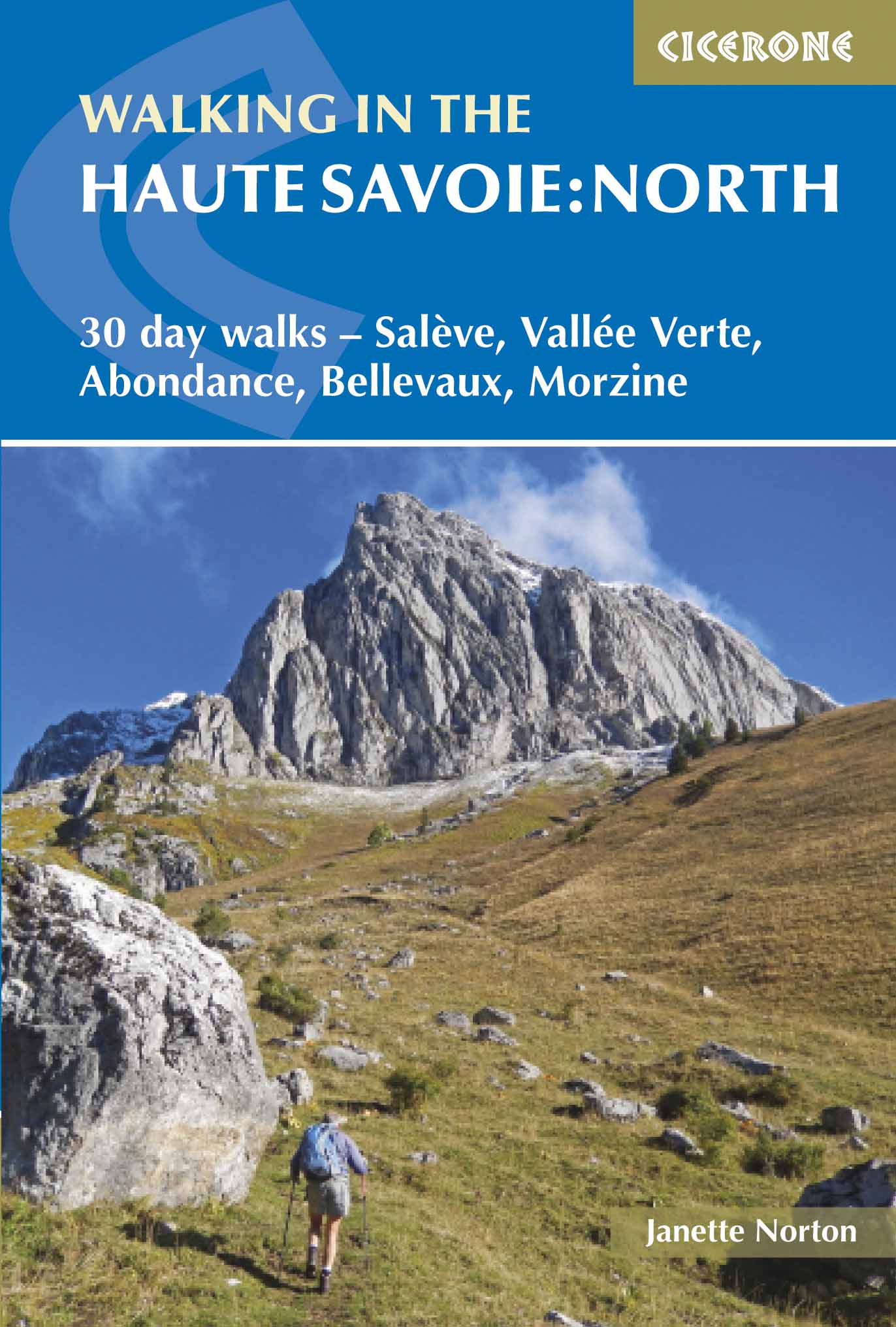
<p> Uitstekende wandelgids van dit geweldige gebied. Goed beschreven met veel praktische informatie om de route te kunnen lopen, inclusief redelijke kaarten.</p> <div> A guidebook of half and full-day walks in the lovely Haute Savoie mountains of France. This guide describes 30 circular routes of between 7 and 13km, based around Evian-les-Bains, Morzine, Abondance, Châtel, St-Julien-en-Genevois, Bellevaux, Boège and Habère-Poche. Graded from easy to difficult, there are walks to suit most abilities, but a few have some exposed sections and need a head for heights.</div> <div> </div> <div> The guide is divided into 6 areas covering the Salève and Vuache, the Vallée Verte, the Vallée du Brevon, Pre-Alpes du Léman and Val d'Abondance. Alongside a detailed route description and map, each walk has a summary of all you need to know before you set out (distance, time to walk, ascent, maximum altitude and instructions for accessing the start). The guidebook includes advice on travel, accommodation and equipment, as well as information about local wildlife and Savoyard food and drink, and a glossary of useful French words.</div> <div> </div> <div> Visitors flock to the Chamonix area and the Mont Blanc range, but that is only part of what the Haute Savoie has to offer. With highlights including Cornettes de Bise, Mont de Grange, Dent d-Oche and Pic Boré, the walks in this guide will show you a quieter, less busy side to this outstandingly beautiful area.</div> <div> </div> <div> <strong>Dorpen en Steden</strong></div> <div> Evian-les-Bains, Morzine, Abondance, Châtel, St-Julien-en-Genevois, Bellevaux, Boège, Habère-Poche</div> <p> </p>
€20,95
Bekijk product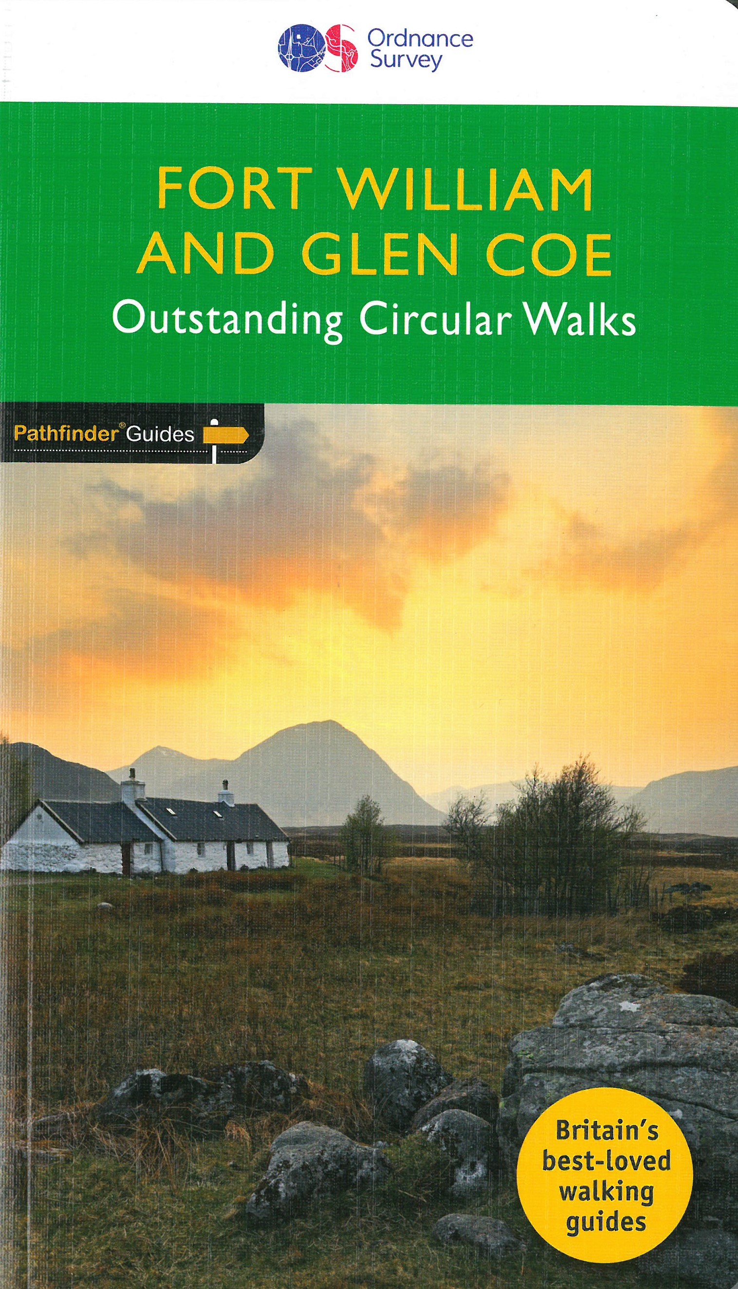
<p> Wandelgids van een deel Schotland. Deze gids bevat 28 dagwandelingen, variërend van korte tochten tot pittige dagtochten. De bijbehorende kaarten zijn uitstekend: men heeft de topografische kaarten van Ordnance Survey gebruikt waarop de route is ingetekend. Daarnaast praktische informatie over de wandeling en wat beschrijvingen van het gebied.</p> <div> Fort William and Glen Coe encompass one of the greatest areas of sea and mountain landscape in Scotland, backed by some of the biggest and most demanding peaks. This is Scotland's fjord land, a drowned coastland with long sea arms wending far inland, and steep climbs from sea level to Ben Nevis, the highest summit in Britain.</div> <div> </div> <div> This walking guidebook contains 28 carefully selected walking routes around Fort William and Glen Coe of 5km (3 miles) to 16km (10 miles), each planned and tested by experienced walkers. Each route includes a full description, an extract of the OS Explorer 1 25 000 scale map, photos and notes of key features and wildlife to look for on the way.</div> <div> </div> <div> The walks include Ben Nevis, the Caledonian Canal, Kinlochleven, Loch Ossian, and Rannoch Moore.</div> <div> </div> <div> Pathfinder Guides are Britain’s best-loved walking guides. Printed with weather-resistant covers featuring durable rounded corners, they are the perfect companion for walking throughout Britain.</div>
€18,50
Bekijk product
<p> Wandelgids van een deel van Engeland, Schotland of Wales. Deze gids bevat 28 dagwandelingen, variërend van korte tochten tot pittige dagtochten. De bijbehorende kaarten zijn uitstekend: men heeft de topografische kaarten van Ordnance Survey gebruikt waarop de route is ingetekend. Daarnaast praktische informatie over de wandeling en wat beschrijvingen van het gebied.</p> <p> Each of the Jarrold Pathfinder titles features 28 circular routes, all tried and tested by seasoned walkers. The routes range from extended strolls to exhilarating hikes, so there is something for everyone.</p> <p> They also contain:</p> <p> -Ordnance Survey mapping;<br /> -background details of each area;<br /> -details of refreshment stops and parking;<br /> -walking safety advice; and<br /> -information about walkers and the law</p> <p> Approaching the eastern part of central Scotland, where the Grampians dominate the horizon, it appears at first glance to be mountain country. In fact much of the area is low-lying, with flat woodland and agricultural land bordered by gentle, rounded hills and an attractive North Sea coastline. Perthshire has enough lochs to vie with Cumbria's Lake District. Dunsinane Hill and the site of Macbeth's castle can be seen on the Sidlaw Hills in Strathmore, Angus, and there are also coastal walks around the Fife peninsula, with its waterfront villages, sheltered harbours and sandy beaches.</p> <p> </p>
€18,50
Bekijk product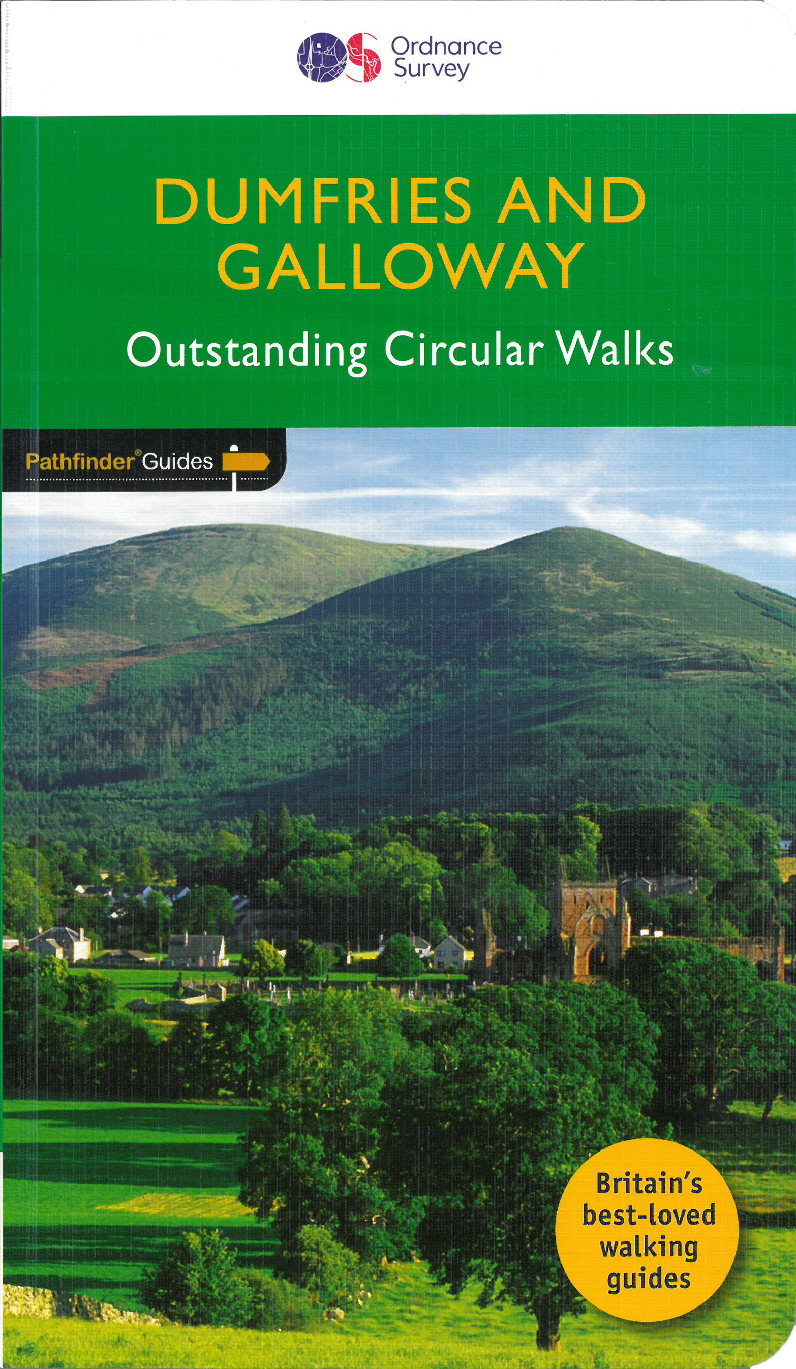
<p> Wandelgids van het zuidwestenl van Schotland. Deze gids bevat 28 dagwandelingen, variërend van korte tochten tot pittige dagtochten. De bijbehorende kaarten zijn uitstekend: men heeft de topografische kaarten van Ordnance Survey gebruikt waarop de route is ingetekend. Daarnaast praktische informatie over de wandeling en wat beschrijvingen van het gebied.</p> <div> With 28 circular walks all created by experienced walkers, this Pathfinder walking guidebook for Dumfries and Galloway is ideal for both visitors and locals. The routes range from extended strolls to exhilarating hikes, so there is something for everyone. Each route includes a detailed description, a difficulty rating, the Ordnance Survey map for the route, GPS waypoints and key historical and landscape features to look out for.</div> <div> </div> <div> Dumfries and Galloway form the south-west of Scotland; a broad wedge of land jutting out into the Irish Sea between the Solway Firth and the Firth of Clyde. The area is also part of Scotland's border country which possesses a mild climate, a great variety of scenery and a rich historic legacy, making it a popular destination for holidays and a lush contrast to the more rugged landscapes found just slightly further north. The mountains of Dumfries and Galloway offer plenty of remote and challenging walking, with over 40 peaks that exceed 2000 feet. Also featured are clifftop walks around the Mull of Galloway and Rascarrel Bay, a route around the Solway Marshes plus the pigramage destination of St Ninian's Cave.</div> <div> </div> <div> Pathfinder Guides are Britain’s best-loved walking guides. Printed with weather-resistant covers featuring durable rounded corners, they are the perfect companion for country walking throughout Britain.</div> <p> </p>
€18,50
Bekijk product
<p> Deze gids een goede beschrijving van de lange afstands route. De kaarten zijn schetsmatig maar wel duidelijk.</p> <div> The Speyside Way is one of Scotland’s Great Trails. It runs for 80 miles (128 km) from the fishing port of Buckie to Aviemore in the foothills of the Cairngorms. Following the lovely valley of the River Spey, you walk through countryside rich in malt whisky and wildlife, along riverside paths, railway trackbed and forest and moorland tracks.</div> <div> </div> <div> The second edition was fully revised, with mapping from Footprint in six panels, updated plans of villages along the Way, including a fresh Grantown plan and directions from the terminus in Buckie. In 2016 we released the revised version of this essential trail guide, with fresh photos, new mapping and many other updates. These included documenting the 6.5-mile route extension to Kincraig, which opened in 2015, and 11-mile Badenoch Way.</div> <div> </div> <div> <div> This guidebook contains all you need to plan and enjoy the Speyside Way:</div> <div> </div> <ul> <li> the Way step-by-step, with summaries of distance, terrain and refreshments</li> <li> other walks including the Badenoch Way and Dufftown circuit</li> <li> habitats and wildlife, including dolphin, osprey and wildcat</li> <li> expanded coverage of whisky-making and distilleries</li> <li> planning information for travel by car, train, bus or plane</li> <li> in full colour, with 70 photographs</li> <li> drop-down map showing the Speyside Way, plus Tomintoul spur (1:100,000)</li> <li> rucksack-friendly and on rainproof paper.</li> </ul> </div> <p> </p>
€22,50
Bekijk product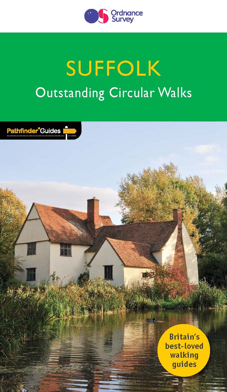
<p> Fraaie, goed verzorgde wandelgidsjes met 28 wandelingen van max. een dag, (beginnend bij korte, eindigend bij langere wandelingen). Weergegeven op duidelijke topografische kaartjes (1:25.000). Bevat verder wetenswaardigheden en praktische informatie voor onderweg.</p> <p> Suffolk's riverside meadows of the Stour valley remain as beautiful today as when Constable painted them two centuries ago. Similarly, the county's lonely expanses of estuarine marsh, which are a feature of the coast, have a quality that appeal to writers as well as artists. A walk through Flatford and East Bergholt passes one of Constable's most famous viewpoints, and Flatford Mill itself. There is a choice of coastal walks, including routes through Southwold, Shingle Street, Dingle Marshes, Thorpeness and the Shotley peninsula.</p> <p> With 28 walks through the Suffolk countryside, if you’re a walker who really wants to make the most of the Suffolk countryside, make sure you don’t set off on your walk without a copy of Pathfinder Guide to Suffolk Walks in your rucksack!</p> <p> Pathfinder® Guidesare Britain’s best loved walking guides. Made with durable covers, they are the perfect companion for countryside walks throughout Britain. Each title features circular walks with easy-to-follow route descriptions, tried and tested by seasoned walkers and accompanied by beautiful photography and clear, large-scale Ordnance Survey mapping.</p>
€18,50
Bekijk product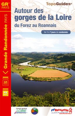
<p> Uitstekende routegids met gedetailleerde kaarten en een routebeschrijving. Fout lopen wordt op deze manier wel erg moeilijk. Met symbolen is weergegeven welke voorzieningen (openbaar vervoer / winkels / overnachtingen) er zijn langs of bij de route. Een nadeel is dat de daadwerkelijke adressen dan weer niet altijd genoemd worden. Alle gidsen bevatten een door ons toegevoegde uitgebreide frans - nederlandse wandelwoordenlijst.</p> <p> En 1, 2 ou 7 jours, vous marcherez sur les traces de l'homme de Neandertal, discernerez différents édifices ayant jalonné le fleuve au fil du temps et permis la navigation entre falaises et rochers depuis 3000 ans, ou visiterez les monuments remarquables au cours de vos randonnées. </p> <p> Entre plaine du Forez et du Roannais, la Loire a percé ce verrou volcanique et modelé le relief. Parfois tumultueuse, elle reste discrète et ne se laisse voir qu’au bord des gorges. Le territoire apparaît comme une succession de collines verdoyantes où les ruisseaux ont creusé des vallons boisés. Les haies forment une mosaïque de milieux variés : prairies, rochers, landes, pelouses sèches, vignes, bosquets…</p> <div> Une variété de sites jalonne le territoire. Villerest et ses ruelles médiévales dominent le barrage du même nom. Saint-Maurice est un vieux village posté en vigie au-dessus des gorges. Le Pet d’Âne offre un point de vue sur le plus grand méandre de la Loire. Près du prieuré de Pommiers-en-Forez, le pont gothique fut abandonné par la rivière. La tour de Cleppé trône dans la plaine du Forez. Le château de la Roche émerge au-dessus des eaux…</div> <div> </div> <div> A noter que les gorges de la Loire sont un lieu de rencontre entre l’eau et les zones sèches, entre les espèces méditerranéennes et celles du nord, d’où une forte diversité de la flore et de la faune. Sous l’appellation "gorges de la Loire aval", le site a ainsi été classé Natura 2000 car 47 espèces d’oiseaux rares y ont été répertoriées.</div>
€17,50
Bekijk product