
Beantwoord enkele vragen, en binnen seconden geeft AI je een persoonlijk aankoopadvies op maat.
Beantwoord enkele vragen, en binnen seconden geeft AI je een persoonlijk aankoopadvies op maat.

<p> Uitstekende routegids met gedetailleerde kaarten en een routebeschrijving. Fout lopen wordt op deze manier wel erg moeilijk. Met symbolen is weergegeven welke voorzieningen (openbaar vervoer / winkels / overnachtingen) er zijn langs of bij de route. Een nadeel is dat de daadwerkelijke adressen dan weer niet genoemd worden.</p> <p> 2 000 kilomètres de sentiers balisés, sa côte, ses édifices remarquables, ses plans d'eau, ses reliefs, sa forêt, sa faune et sa flore méditerranéennes... le Var offre une multitude de terrains propices à la randonnée pédestre en toutes saisons.</p> <div> Au nord du département, sur les premiers contreforts des Alpes, de minces torrents se fraient un passage dans les interstices rocheux d'un relief tourmenté. C'est un pays de landes à moutons et de chênes verts, où vergers, vignobles et oliveraies ont la part belle. Pour se protéger des sarrasins venus de la mer les villages y sont parfois perchés.</div> <div> </div> <div> La côte, elle, se découpe en rades, golfes et criques rocheuses. De multiples corniches offrent une vue inoubliable sur les îles qui sommeillent à quelques encablures, entourées de bleu profond. autant d'éléments propices au développement du tourisme balnéaire, dont les sites et stations sont mondialement connues : Saint-Tropez, Bandol, Le Lavandou, la presqu'île de Giens...</div>
€17,50
Bekijk product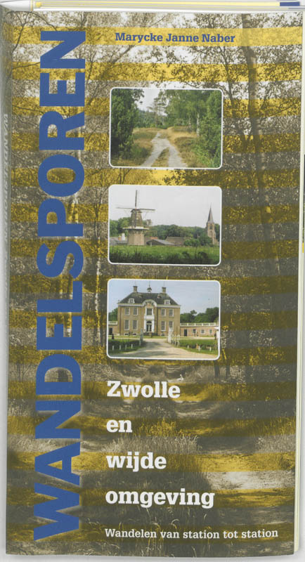
<p> De Zwolse schrijver-kunstenaar Marycke Naber laat zien wat een bijzondere wandelmogelijkheden er zijn rond de grotere steden van Nederland. Zij beschrijft een netwerk van routes die aansluiten op het NS-netwerk. Zo kunnen dagtochten aaneen geregen worden tot meerdaagse tochten. De dagtochten kunne ook verkort worden door gebruik te maken van het OV-net.</p> <p> De uitgave beschrijft ruim 60 wandelroutes in het afwisselende Overijsselse en Gelderse landschap rond Zwolle, met veel onverharde paden. Rust en ruimte voeren hier de boventoon. De gids geeft veel informatie over horeca, bezienswaardigheden en openbaar vervoer.</p> <p> De routes zijn ingetekend in kaartjes. Het boek heeft een ringband en is uitgevoerd in klein formaat met slappe kaft, om het zo bij je te steken.</p>
€17,95
Bekijk product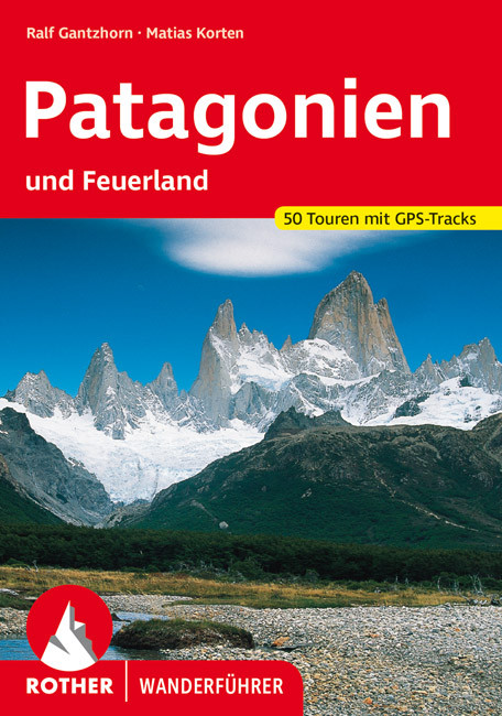
<p> Uitstekende wandelgids met een groot aantal dagtochten in dal en hooggebergte. Met praktische informatie en beperkt kaartmateriaal! Wandelingen in verschillende zwaarte weergegeven in rood/blauw/zwart.</p> <p> 50 Wanderkärtchen im Maßstab 1:50.000, 1:100.000, 1:150.000 und 1:200.000, 50 Höhenprofile sowie zwei Übersichtskarten im Maßstab 1:7.500.000 und 1:12.500.000</p> <p> Patagonien, das Land am sturmumtosten Südzipfel des südamerikanischen Kontinents, und die vorgelagerten Feuerland-Inseln beherbergen einige der faszinierendsten Landschaftsräume der Erde: Immergrüner Regenwald neben gigantischen blaugrünen Gletschern, die endlos staubige Weite der Pampa unterhalb der eisüberkrusteten Gipfel von Fitz Roy und Cerro Torre, die Parklandschaft des Seengebiets zwischen einsamen Stränden am Pazifik und wüstenhaften Vulkanlandschaften in den Anden.</p> <p> Die Autoren Ralf Gantzhorn und Thomas Wilken haben Patagonien - das ihrer Meinung nach schönste Ende der Welt - als Fotograf und Bildbandautor (Ralf Gantzhorn) sowie Reiseveranstalter und Reiseleiter (Thomas Wilken) über Jahre regelmäßig bereist und dabei vielerorts auch unberührte Trekkingpfade abseits der populären touristischen Ziele erkundet. In diesem Rother Wanderführer stellen sie 50 der interessantesten und lohnenswertesten Wander- und Trekkingrouten vor und geben mit ebenso präzisen wie anschaulichen Wegbeschreibungen ihre persönlichen Erfahrungen an diejenigen weiter, die diesen Teil Lateinamerikas zu Fuß entdecken wollen. Das vielfältige Angebot reicht von eher gemütlichen Wanderungen bis zu äußerst anspruchsvollen mehrtägigen Touren über die Patagonischen Eisfelder.</p> <p> In einem ausführlichen Einführungsteil erfährt der Leser alles, was er sowohl über Land und Leute als auch über die Planung und Organisation einer Trekkingreise nach Chile und Argentinien wissen muss. Aktuelle Tipps zu Ansprechpartnern, Unterkünften, Restaurants und Verkehrsverbindungen bei jeder Tour helfen auch vor Ort verlässlich weiter. Karten mit eingezeichnetem Routenverlauf, aussagekräftige Höhenprofile und nicht zuletzt zahlreiche Bilder ergänzen die detaillierten Wegbeschreibungen und laden ein, Patagonien wandernd zu erleben.</p>
€21,95
Bekijk product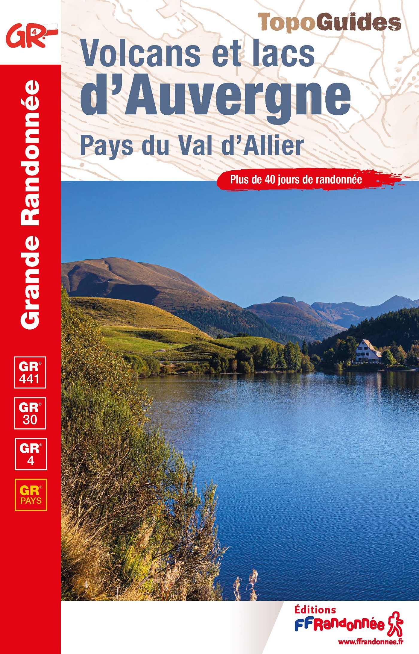
<div> Uitstekende routegids met gedetailleerde kaarten en een routebeschrijving. Fout lopen wordt op deze manier wel erg moeilijk. Met symbolen is weergegeven welke voorzieningen (openbaar vervoer / winkels / overnachtingen) er zijn langs of bij de route. De gids bevat een lijst met overnachtingsadressen inclusief telefoonnummers. Alle gidsen bevatten een door ons toegevoegde uitgebreide frans - nederlandse wandelwoordenlijst.</div> <div> </div> <div> Plus de 40 jours de randonnée à travers la chaîne des Puys pour découvrir les volcans d'Auvergne : Puy de Dôme, Puy de Sancy, Puy Chopine...</div> <div> </div> <div> <div> Aux portes de Clermont-Ferrand, les formations volcaniques dévoilent un véritable musée à ciel ouvert.</div> <div> </div> <div> Ce topoguide conduira le randonneur sur la chaîne des Puys (GR® 441) et ses 80 volcans dont les plus connus le Puy de Dôme, le Puy de Sancy, le Puy Chopine et le Puy de l'Angle.</div> <div> </div> <div> Au sud, une superbe boucle au départ du Mont-Dore, afin de réaliser le tour des lacs d'Auvergne le temps d'une itinérance de 9 jours étendue sur 198 kilomètres.</div> </div> <p> </p>
€21,95
Bekijk product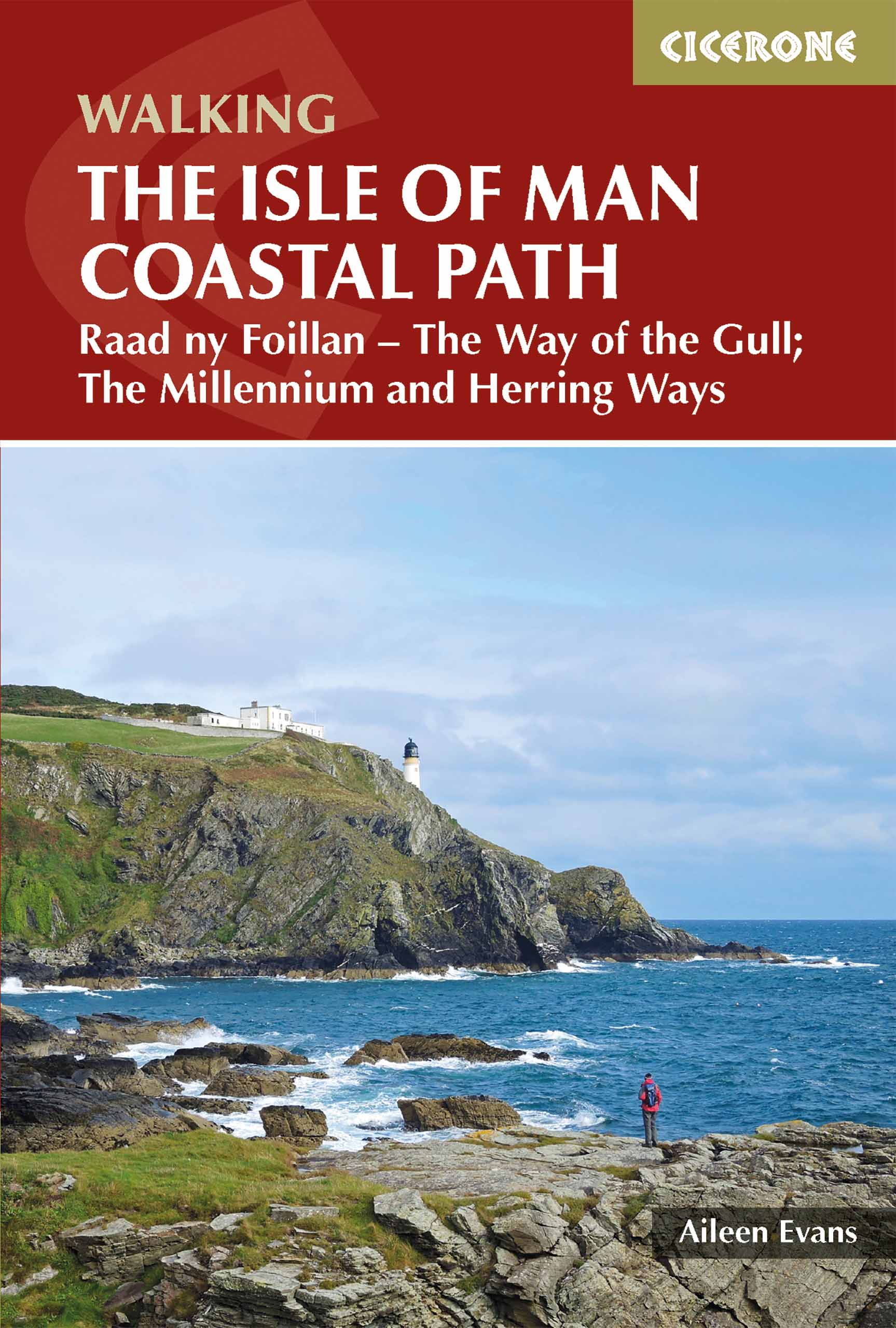
<p> Perfect wandelgidsje met geweldige routes op dit prachtige eiland tussen Engeland en Ierland. Goed beschreven, met veel details om de wandelingen te kunnen volgen, kaartmateriaal voldoende.</p> <div> Guidebook to walking the Isle of Man coastal path, the Way of the Gull (Raad ny Foillan). The spectacular 98 mile route is described in 9 stages and takes in beaches, glens, moorland and rugged sea cliffs. It can be walked in around a week. Two other paths, the Millennium Way (Bayr ny Ree) and the Herring Way (Bayr ny Skeddan), are also described.</div> <div> </div> <div> Seasons </div> <div> Year-round walking on the Isle of Man is possible, although spring and summer weather is best. April, May and June are driest; May, June and July are sunniest; July and August are warmest.</div> <div> </div> <div> Centres </div> <div> Douglas, Ramsey, Castletown, Port Erin, Peel, Kirk Michael</div> <div> </div> <div> Difficulty</div> <div> Mainly coastal walking with short ups and downs. Stages up to 15 miles long.</div> <div> </div> <div> Must See </div> <div> Point of Ayre, historic Laxey, the cliffs and secluded bays and inlets of the south and west and the remote west coast. Sea life and birds.</div>
€18,50
Bekijk product
<p> Een uitstekende beschrijving van het beroemde lange afstandspad in Californie.</p> <p> Guidebook to walking the John Muir Trail through California's High Sierra from Yosemite (El Capitan and Half Dome) to the summit of Mount Witney. The 216 mile hike is split into 21 daily stages, with full information on preparation, permits, wilderness, bears, water and trekking skills. Part of the Pacific Crest Trail.</p> <p> The John Muir Trail (JMT) is one of the world’s most spectacular treks and is North America’s best known mid-distance walking trail. It runs for 216 miles through the high Sierra Nevada mountains of California, from Yosemite Valley to the summit of Mount Whitney (14, 496ft), the highest peak in the USA outside Alaska. The walking trail, which is named after the great 19th-century Scottish naturalist, conservationist and writer John Muir, is entirely through the unspoilt wilderness of the American West and passes through three national parks: Yosemite, Kings Canyon and Sequoia National Parks.</p> <p> To walk the John Muir Trail successfully thorough planning is required. All you need to know to plan and prepare for your trip is contained within these pages, from obtaining trekking permits to buying trek food and forwarding food caches along the trail. Abundant advice is given on such topics as dealing with inquisitive bears, coping with altitude, negotiating river crossings, as well as tips on booking transport to and from the trailheads and on what equipment to take. In addition there is a detailed description of the flora and fauna of this remarkable region.</p> <p> <strong>Steden en Dorpen</strong></p> <p> Starts Yosemite and finishes at Whitney Portal; Tuolmmne, Vermilion Resort and Muir Trail Range along the way; access through San Francisco or Los Angeles</p>
€25,95
Bekijk product
<p> Wandelgids met 56 wandelingen op 12 eilanden. Het boekje beschrijft de mooiste oude wandelroutes. Met gedetaileerde kaartjes, looptijden, GPS points en foto's van standpunten voor een betere orientatie. Met :</p> <p> Amorgós<br /> Ándros<br /> Antíparos<br /> Donoússa<br /> Irakliá<br /> Koufonísi<br /> Mýkonos<br /> Náxos<br /> Páros<br /> Schinoússa<br /> Sýros<br /> Tínos</p> <p> <strong>Van de uitgever</strong></p> <div> This book describes the loveliest old walking trails. With precise descriptions, detailed maps, exact times, GPS points and photos of outstanding places for better orientation. And lots of useful knowledge about the "Islands of Light." It is made for island hoppers who want to drift through the island world by ship and who would also like to hike and swim in this ancient cultural landscape.</div> <div> </div> <div> For the update of this new edition all the tracks and paths have been newly walked along and rechecked. All extensions, some of them also changed routes, are recorded. And 12 new hikes have been added.</div> <div> </div> <div> White, cubical houses in front of infinitely blue sea – that is how we know Greece from the travel brochures. The Cyclades fit this picture perfectly. The name of the archipelago is derived from Antiquity and implies that they are arranged like a circle, a kyklos, around the holy island of Délos. Out of 56 islands in total, 24 are inhabited and they are all described in this series of books. They are linked together by numerous and frequent boat services, which makes „island-hopping“ such a special experience. Besides serving the more well-known islands such as Páros and Náxos, the boats also ferry you to the „Small Cyclades“, which occasionally make you feel as if you had been taken back to the beginnings of tourism.</div> <div> </div> <div> Given the variedness of the Cycladic islands, it takes quite a while to find your favourite island. It is best to discover the diversity of the islands on foot. Old paved mule tracks wind their way across the extensive landscape and, bordered by walls, lead to fortified monasteries, lonely strands and clustered villages. Surrounded by the sea, the countryside, which hardly has any fences, lends itself particularly to hiking. You reach places where sometimes nobody has set foot for days or even weeks. Far removed from tourist facilities, the hiker finds the old Greece and what is more, in the tranquillity of the nature, peace of mind. In the mountain villages the hiker encounters open-minded people who let him, the „stranger“, be „guest“ – in Greek both concepts are expressed in one word, “xénos”.</div> <div> </div> <div> Of the twelve islands presented here Amorgós and Náxos as well as Andros and Tínos can be especially recommended for walking. Yet the others also have many attractions which are worth discovering. Have a good trip! Kaló taxídi!</div>
€19,50
Bekijk product
<p> Uitstekende wandelgids van dit geweldige gebied. goed beschreven met veel praktische informatie om de route te kunnen lopen, inclusief goede kaarten.</p> <p> The official guide to backpacking or walking the Wye Valley Walk, 136 miles through the Welsh borders, crossing between south Wales and Herefordshire, from Chepstow to Plynlimon. Easy walking through wooded gorges, riverside meadows and open moorland, passing sites such as Tintern Abbey, Goodrich Castle, Hereford Cathedral and Hay-on-Wye.</p> <p> The Wye Valley Way offers a perfect mix of river and hill walking as it follows the River Wye for 136 miles from river’s mouth at Chepstow to the slopes of Plynlimon in Powys criss -crossing the border between England and Wales. The walk leads through a dramatic limestone gorge, dense woodland beneath limestone crags and past peaceful river meadows in some of the most superb scenery in the heart of the Wye Valley Area of Outstanding Natural Beauty, the birthplace of tourism and the Picturesque movement. The route passes through historic Tintern, Monmouth and Ross-on-Wye and into the gentler rolling landscape of Herefordshire with black and white villages, famed cider orchards, landscaped parks and fertile agricultural plains into the rugged uplands of Powys.</p> <p> The new official guide describes the whole route in detail, from Chepstow to its source in Hafren Forest, all illustrated with colour photographs and OS map extracts, and also includes a Wye Valley Walk passport, for walkers to collect stamps along the route for a permanent record of their journey.</p> <p> Steden en Dorpen</p> <p> Chepstow, Monmouth, Ross-on-Wye, Hereford, Hay-on-Wye, Builith Wells, Rhayader</p>
€21,95
Bekijk product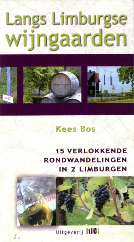
<p> Limburgse wijngaarden liggen vaak op nog onbedorven plekjes.</p> <p> Tussen de heuvels, langs rivieren en beken, in fruitteeltgebieden en zelfs aan de rand van de stad Maastricht zijn de mooiste wandelingen te maken. U ziet waar de laatste decennia de druiven worden gekoesterd die resulteren in heerlijke wijnen. Wandelaar Kees Bos schreef eerder het wandelboekje ‘Vervoering in de Voerstreek’, maar hij moet menigmaal in vervoering zijn geraakt tijdens zijn tochten en zoektochten naar de beste wandelwegen langs Limburgse wijngaarden.<br /> De 15 wandelroutes varierend van 7 tot 13,5 km lengte lopen door Nederlands en Belgisch Limburg. Met goede routebeschrijvingen, veel informatie over de bezienswaardigheden, veel foto’s en overzichtelijke kaarten.</p>
€10,90
Bekijk product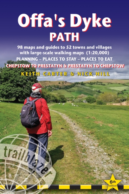
<div> Goede wandelgids van de Offa's Dyke Path. Met veel details zijn alle etappes beschreven. Tevens informatie over overnachtingen en openbaar vervoer.</div> <div> </div> <div> <div> <div> All the information you need to walk Offa's Dyke Path in this two-way edition, with routes re-walked in both directions - from Chepstow to Prestatyn and from Prestatyn to Chepstow and reformatted for use by walkers hiking south to north and north to south. The Offa's Dyke Path is a magnificent National Trail that runs from the North Wales coast to the Severn Estuary following the line of Offa's Dyke, an impressive 8th century earthwork along the English/Welsh border. The ever-changing landscape - the Wye Valley, the Black Mountains, the Shropshire Hills and the Clwydian Hills - is steeped in history and legend providing 177 miles of fascinating walking.</div> <div> </div> <div> This sixth edition has been re-walked and fully updated and includes:98 walking maps - 1:20,000 (3 and 1/8 inches to 1 mile) - the largest-scale maps availableUnique mapping features - walking times, directions, tricky junctions, places to stay, places to eat, points of interestItineraries for all walkers - whether walking the route in its entirety or sampling the highlights on day walks and short breaksPractical information for all budgets - what to see, where to stay, where to eat: pubs, B&Bs, hotels, campsites, hostels, with reviewsGuides to 52 towns and villages - along the wayPublic transport information - for all access points on the pathGPS waypoints - also downloadable from the Trailblazer website Includes extra colour sections: 16pp colour introduction and 16pp of colour mapping for stage sections (one stage per page) with trail profiles</div> </div> </div> <p> </p>
€21,95
Bekijk product