
Beantwoord enkele vragen, en binnen seconden geeft AI je een persoonlijk aankoopadvies op maat.
Beantwoord enkele vragen, en binnen seconden geeft AI je een persoonlijk aankoopadvies op maat.
<p> Uitstekende wandelgids met een groot aantal dagtochten in dal en hooggebergte. Met praktische informatie en beperkt kaartmateriaal! Wandelingen in verschillende zwaarte weergegeven in rood/blauw/zwart.</p> <p> Let op! Franstalig!</p> <div> La Sardaigne, deuxième île de la Méditerranée par sa taille, est l’une des destinations les plus appréciées des baigneurs en Europe. Les touristes qui débarquent ici pour la première fois sont étonnés de découvrir que la Sardaigne est montagneuse. Ils le sont encore plus lorsqu’ils apprennent que l’île offre d’innombrables itinéraires de randonnée et d’alpinisme. Voilà justement qui fait le charme de l’île : aller en Sardaigne non pas pour se baigner mais pour y faire de la randonnée, une nouvelle expérience en somme. L’île surprend les visiteurs par la diversité de ses extraordinaires décors paradisiaques à la beauté sauvage du littoral escarpé et déchiqueté à l’est, à travers les montagnes majestueuses au centre jusqu’aux paysages doucement vallonnés à l’ouest – et n’oublions pas de mentionner les foisonnantes régions forestières au sud et les étranges chaînes granitiques au nord.</div> <div> Walter Iwersen et Elisabeth van de Wetering proposent dans ce tout nouveau guide 63 randonnées choisies au total – de la promenade tranquille en bordure de plage jusqu’au périple aventureux sur les falaises. Point fort de cet ouvrage, le lecteur sera heureux d’y trouver pour chaque randonnée, outre de très belles photos couleurs, des petites cartes de randonnée très pratiques, des profils d’altitude clairs et une description minutieusement détaillée des itinéraires, les coordonnées GPS correspondantes qu’il pourra télécharger gratuitement sur Internet.</div> <div> Un guide parfaitement réussi, incontournable pour tous ceux qui ont choisi de partir en vacances en Sardaigne !</div>
€18,50
Bekijk product
<div> Malcolm Leatherdale has chosen 15 of the best short walks around Winchester and central Hampshire for you to explore. Our guide comes with easy-to-read Ordnance Survey maps and clear route descriptions, perfect if you're new to walking or are looking for something you can enjoy with the whole family. We've included information on local history, beauty spots and tasty refreshment stops, and most of the walks can be completed in under 3 hours.</div> <div> </div> <div> We haven't included any walks with challenging terrain or complicated navigation, and all you'll need to take with you are a waterproof jacket and a pair of comfortable trainers.</div>
€13,95
Bekijk product
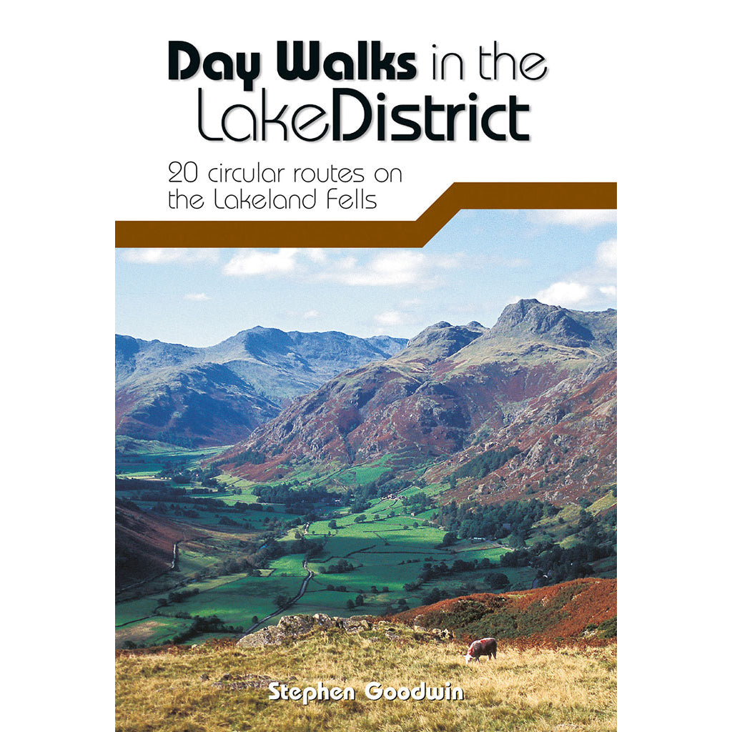
<div> Day Walks in the Lake District features 20 circular routes between 5 and 13 miles (8 and 21 kilometres) in length, suitable for hillwalkers of all abilities. The routes are split into four geographical areas - north, east, south and west - and include walks from the main tourist bases, such as Keswick and Ambleside, as well as sought after peaks, such as Scafell Pike, Great Gable, Blencathra and Helvellyn. Also included for the adventurous are the Lake District's best known scrambles - Striding Edge on Helvellyn and Sharp Edge on Blencathra - together with more accessible alternatives.</div> <div> </div> <div> The author of this guidebook, Stephen Goodwin, is a former freelance journalist (former staff writer for The Independent), and a Lake District local. In his introductions to each route he recalls the tales of Wordsworth, Walpole and the fascinating history of Lakeland and its peaks and fells. Each route in this guide is described with easy-to-follow directions and details of distance, navigation information, refreshment stops, stunning location photography and is plotted on clear and easy to use Ordnance Survey 1:25,000 mapping.</div>
€20,95
Bekijk product
<div> Day Walks on the North York Moors showcases 20 circular walks, between 5 and 13.7 miles (8 and 22 kilometres) in length, suitable for hillwalkers of all abilities. The routes are split into three areas - The Cleveland Hills and Hambleton Hills, Central Moors and Coastal Walks - and include walks to the most historic and beautiful areas of the Moors, including: Lord Stones, Wainstones and Clay Bank, Rievaulx Abbey, Blakey Ridge and Farndale, the Hole of Horcum, and the stunning coastline at Robin Hood's Bay and Ravenscar. The author of this guidebook, Tony Harker, is a Moors local and keen hillwalker.</div> <div> </div> <div> Each route in this guide is described with easy-to-follow directions and details of distance, navigation information and refreshment stops, and is plotted on clear and easy to use Ordnance Survey 1:25,000 maps. The walks are illustrated with stunning photography by Adam Long. Also included is a detailed Appendix.</div>
€20,95
Bekijk product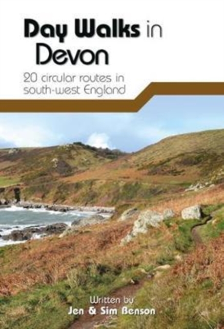
<div> Day Walks in Devon features 20 circular routes, between 8.8 and 17.6 miles (14.1km and 28.3km), suitable for hillwalkers of all abilities. The routes are split into five geographical areas: North Devon and Exmoor, Torridge and West Devon, Mid and East Devon, Dartmoor, and South Devon and the South Hams. Devon has some of the most diverse and beautiful terrain of any county in England.</div> <div> </div> <div> Local authors Jen and Sim Benson share their favourite walks in the region, including coastal circuits taking in sections of the South West Coast Path past Baggy Point and Hartland Point; moorland loops of Dartmoor's granite tors such as Haytor and High Willhays; and tours through the county's rich history at Berry Pomeroy Castle and Castle Drogo. Together with stunning photography, each route features Ordnance Survey 1:25,000 maps, easy-to-follow directions, details of distance and navigation information, and refreshment stops and local information.</div>
€20,95
Bekijk product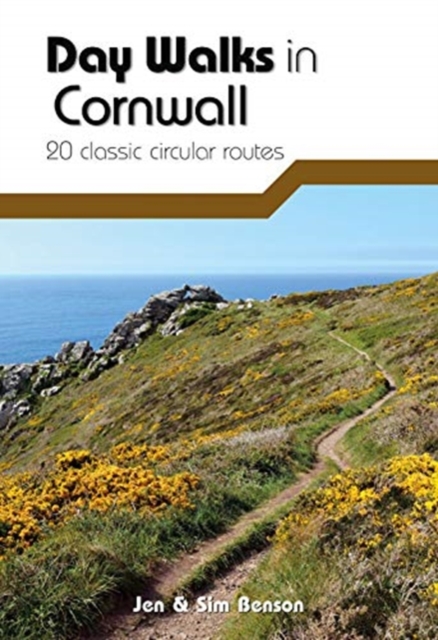
<div> Day Walks in Cornwall features 20 circular routes between 7.2 and 13.7 miles (11.6km and 22km) in length, suitable for hillwalkers of all abilities. Researched and written by experienced authors Jen and Sim Benson, and covering the extremities of this stunning peninsula, the walks reach areas from Bude to the Isles of Scilly, and from Rame Head near Plymouth to Lizard Point on the southernmost tip. Taking advantage of the South West Coast Path, discover a unique view of the charming coastline at every turn in this Area of Outstanding Natural Beauty.</div> <div> </div> <div> Explore Chapel Porth caves, and countless coves, archways and waterfalls, or simply immerse yourself in a leisurely stroll along white sands and blue waters. Head for the Merry Maidens stone circle in Lamorna, examine the serpentinite rock formations at Lizard Point, watch over medieval Tintagel Castle and parade past Cromwell's Castle. Find serenity overlooking St Enodoc's Church or soak up the vibe of trendy fishing village St Mawes, nestled in its sheltered bay; you'll find Cornwall has it all.</div> <div> </div> <div> Together with stunning photography, each route features Ordnance Survey 1:25,000 maps, easy-to-follow directions, distance and navigation information, refreshment stops and local information.</div>
€20,95
Bekijk product
<div> Day Walks in Snowdonia showcases 20 circular routes, between 5.5 and 12 miles (9km and 19km) in length, suitable for hillwalkers of all abilities. Additionally included in a Bonus Section are two of the UK's classic scrambles: The Bochlwyd Horseshoe and The Snowdon Horseshoe. The routes are split into three areas - Northern Snowdonia, Central Snowdonia and Southern Snowdonia - and include walks to the most iconic and beautiful peaks in the National Park, including; Snowdon, Y Glyderau, the Carneddau peaks, Moel Siabod, Cnicht, the Rhinogs, and Cadair Idris.</div> <div> </div> <div> The author of this guidebook, Tom Hutton, is a Wales local, keen hillwalker and outdoors journalist. Each route in this guide is described with easy-to-follow directions and details of distance, navigation information, refreshment stops and public transport information, and is plotted on clear and easy to use Ordnance Survey 1:25,000 mapping. Also included is a detailed Appendix.</div>
€20,95
Bekijk product