
Beantwoord enkele vragen, en binnen seconden geeft AI je een persoonlijk aankoopadvies op maat.
Beantwoord enkele vragen, en binnen seconden geeft AI je een persoonlijk aankoopadvies op maat.
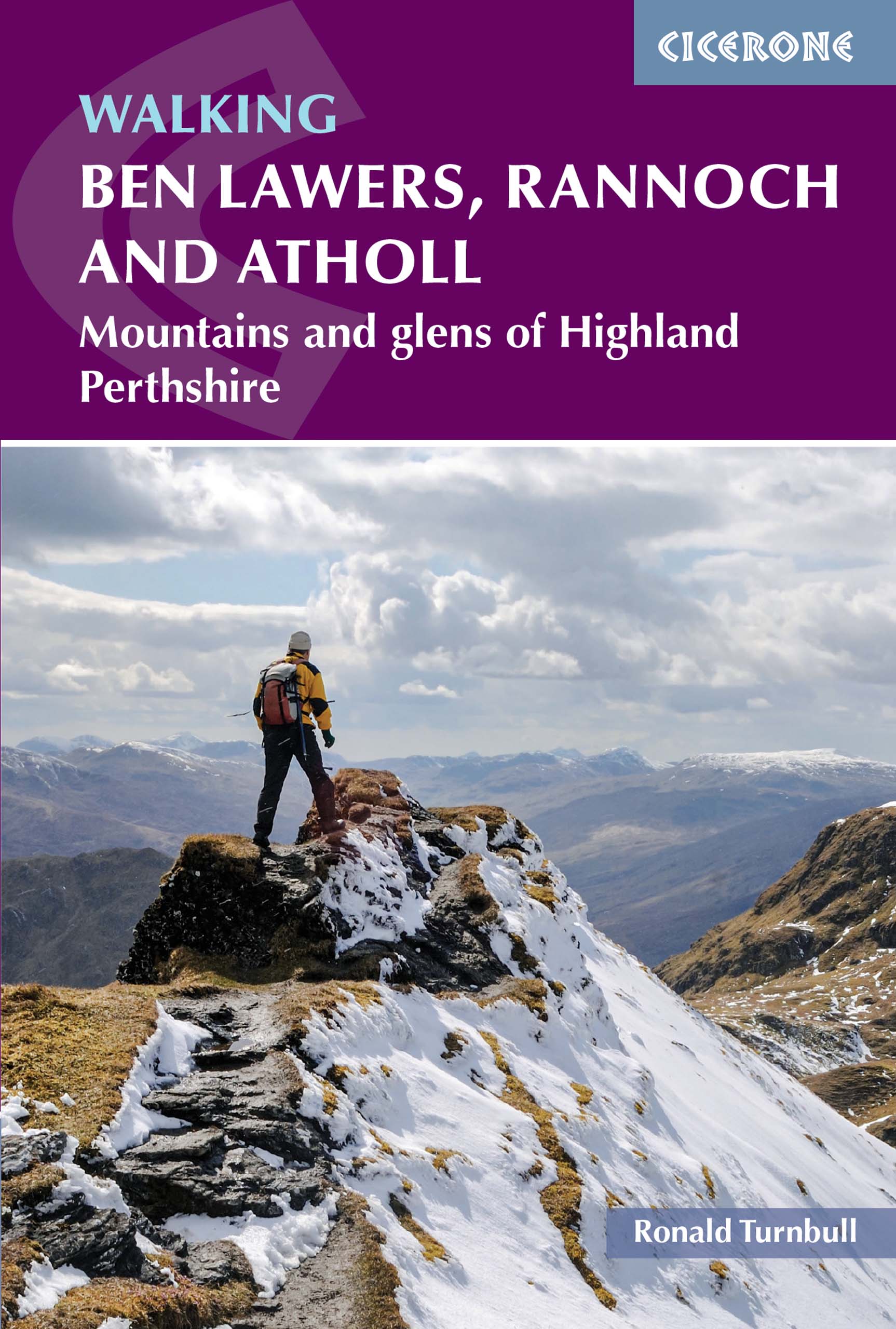
<p> Wandelgids met 80 wandelingen van verschillende niveaus in het gebied van de Perthshire Highlands. </p> <div> The south-eastern Grampians of the former county of Perthshire may be grassier and less rugged than other Scottish mountains, but they are just as big. The routes in this guide take you to the summits of these 'jolly green giants' - covering all of the region's Munros, often by unconventional routes, as well as several Corbetts and smaller hills - and also over the Atholl passes, along rivers and through the woods of Perthshire's 'Big Tree Country'. The 80 walks comprise a mixture of low-level, mid-level and mountain routes and are graded by both length and difficulty. Many are demanding, crossing remote, uneven, steep and/or pathless terrain, but also included are gentler walks on clear paths taking in local features of interest.</div> <div> </div> <div> The route description is illustrated with clear mapping (a mixture of OS 1:50,000 and smaller-scale maps for the longer routes) and the route summary table and grading information make it easy to choose an appropriate route. There is a wealth of information about the landscape and the region's fascinating history. Finally, appendices cover local facilities and access to the hills during the deer-stalking season.</div> <div> </div> <div> With highlights including the mighty Ben Lawers, Beinn Dorain, Ben Alder and Beinn a' Ghlo; Schiehallion; the great rivers Tay and Garry; the Birks of Aberfeldy; and old drovers' routes over the passes of Minigaig and Gaick, Perthshire has plenty to offer. And with historic towns, such as Perth and Pitlochry, and attractive villages, this is an ideal base for a walking holiday.</div>
€19,95
Bekijk product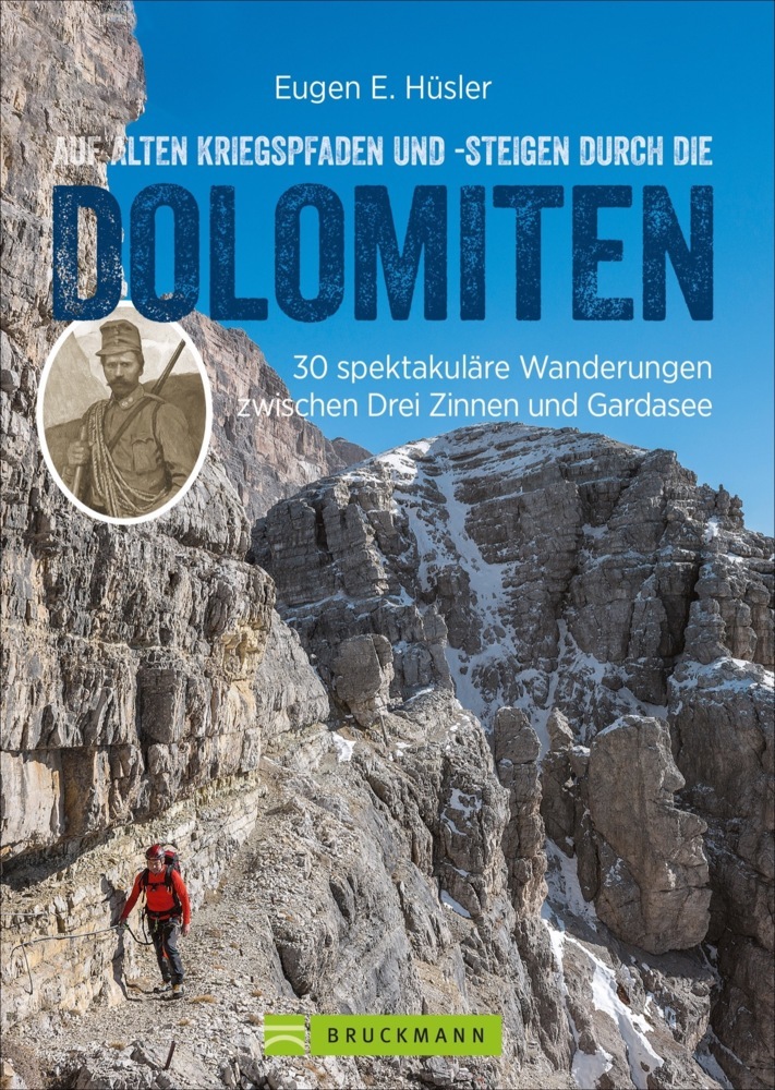
<p> Die Dolomiten waren vor hundert Jahren Kriegsgebiet. Kanonendonner hallte von den Felsen wider, es wurde gekämpft und gestorben in einer grandiosen Kulisse. Noch heute stößt man auf Relikte dieser unseligen Zeit, Weg und Stellungen sind teilweise erhalten. Eugen E. Hüsler stellt 30 Touren entlang der ehemaligen Frontlinie vor, von den Sextener Dolomiten über die Marmolada bis zum Hochplateau von Lavarone und zum Pasubio.</p>
€22,95
Bekijk product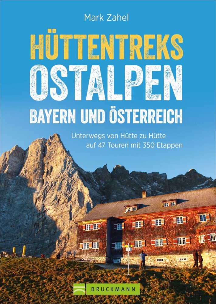
<p> Hüttenwandern in den Ostalpen für Wochenendtouren und längere Wanderurlaube - ein Standardwerk für alle Alpinwanderer.</p> <p> Ihre Sehnsucht Berg stillen Sie am besten bei einem längeren Aufenthalt in den Alpen, urige Hüttenübernachtungen inklusive. Vom beschaulichen Almweg bis hin zur hohen Route liefert Ihnen Mark Zahel alle relevanten Mehrtagestouren der Ostalpen in einem Standardwerk. Ob für Bayern oder Österreich – passionierte Bergwanderer finden eine dichte Auswahl an Hüttentreks, akribisch recherchiert, fundiert beschrieben und lustmachend bebildert</p> <p> Huttentocht</p>
€31,95
Bekijk product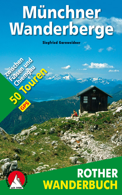
<p> De ‘Rother Wanderbücher’ behandelen telkens de 50 mooiste wandelingen, die variëren van eenvoudige kindvriendelijke wandelingen tot routes die aanzienlijk meer ervaring vereisen. Uitvoerige routebeschrijvingen, een aantrekkelijke lay-out met vele kleurenfoto’s, niets aan duidelijkheid te wensen gelaten hoogteprofielen, kaartjes met de ingetekende route en enige achtergrondinformatie. Het verschil met de rode wandelgidsjes van Rother is dat ze een groter gebied bestrijken: handig voor de één, minder bruikbaar voor de ander.</p> <p> </p> <div> 176 Seiten mit 141 Farbabbildungen </div> <div> 50 Wanderkärtchen im Maßstab 1:50.000, 50 Höhenprofile, GPS-Daten zum Download, eine Übersichtskarte </div> <div> </div> <div> Die Münchner Hausberge, ein ausgesprochen beliebtes und viel besuchtes Ausflugs- und Urlaubsgebiet, vereinen auf engem Raum unterschiedlichste Landschaftsformen - von den sanften Wiesenkuppen, ausgedehnten Wäldern, lieblichen Almen und aussichtsreichen Gipfelhöhen in den Bayerischen Voralpen, den Ammergauer Alpen und im Chiemgau bis hin zu den schroffen und teilweise recht anspruchsvollen Felsgipfeln des Wetterstein- und Karwendelgebirges. In diesem Rother Wanderbuch beschreibt Siegfried Garnweidner 50 schöne und abwechslungsreiche Wanderungen in den Bayerischen Alpen zwischen Lech, Inn und Chiemsee. Der Schwerpunkt des Tourenangebotes liegt bei den einfacheren Bergwanderungen, aber auch Freunde der etwas "schärferen Art" kommen voll auf ihre Kosten. Es sind alle Münchner Hausberge von Rang und Namen vertreten, darüber hinaus wird auch mancher Geheimtipp vorgestellt. So reicht die Palette von der familienfreundlichen Halbtageswanderung auf den knapp 1350 m hohen Zwiesel in den Bayerischen Voralpen bis hin zur anspruchsvollen Bergtour durch das Höllental auf Deutschlands höchsten Gipfel, die 2962 m hohe Zugspitze. Ein Tourensteckbrief, farbige Wanderkarten im Maßstab 1:50.000 mit eingetragenem Routenverlauf, aussagekräftige Höhenprofile, eine ausführliche Wegbeschreibung und Farbfotos zu jeder Tour erleichtern dem Wanderer die Planung und die Durchführung seiner Exkursionen. Zahlreiche Tipps und Informationen, unter anderem zur Geologie sowie zur Tier- und Pflanzenwelt, komplettieren diesen Wanderführer. Ein benutzerfreundliches Extra ist die Tourentabelle auf der vorderen Umschlagklappe, die dem Leser einen Überblick über Familienfreundlichkeit, Einkehr- und Übernachtungsmöglichkeit, Begehungshäufigkeit, Wintertauglichkeit sowie zur Länge und Schwierigkeit der einzelnen Touren vermittelt. Zusammen mit der Übersichtskarte auf der hinteren Umschlagklappe ermöglicht sie die schnelle und gezielte Auswahl einer geeigneten Tour. Mit der nun vorliegenden sechsten, vollständig überarbeiteten Auflage stehen zudem auch zu jeder Tour die GPS-Daten zum Download bereit.</div>
€17,50
Bekijk product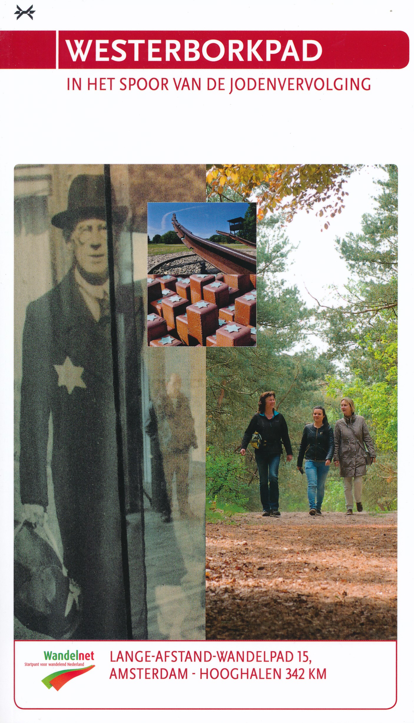
<div> In 2005 werd Jan Dokter uit Hoorn 70 jaar. Hij schreef in oktober van dat jaar: “Waarom wil ik 60 jaar na het vreselijke gebeuren met mijn eigen ogen de plaats zien vanwaar mijn familie is gedeporteerd naar vernietigingskampen?”</div> <div> </div> <div> Ter nagedachtenis aan zijn familieleden liep hij de route van de Hollandse Schouwburg in Amsterdam naar kamp Westerbork in Hooghalen. Dat was de inspiratiebron om van het Westerborkpad een officiële wandelroute te maken.</div> <div> </div> <div> 342 Kilometer, langs de spoorlijn, 70 historische sporen, rolstoel toegankelijk, ondersteund door een wandelgids, aanvulling vanuit een website en luisterplaatsen in het veld met talloze wetenswaardigheden. Een unieke combinatie van toevoegingen aan een wandelpad dat daarmee terecht een bijzonder pad genoemd mag worden.</div>
€19,45
Bekijk product
<p> </p> <div> The Swiss Alps are home to the highest and most spectacular mountains in Western Europe. This stunning guidebook describes each mountain area throughout Switzerland – the peaks, passes, valleys and bases – to help you identify the best destinations to plan your trip.</div> <div> </div> <div> Questions such as ‘Where to walk, climb or ski?’, ‘What multi-day treks are available’ and ‘Where do they go?’, ‘Where are the mountain huts, what are their facilities, which peaks do they serve?’ And where are the most suitable valley bases?’ – all these and more are addressed in detail in this essential guidebook.</div> <div> </div> <div> The Swiss Alps does not give detailed route directions but information is given about all the guides and maps available for every region.</div> <div> </div> <div> The Swiss Alps by Kev Reynolds is the third book in Cicerone’s World Mountain Ranges series, which include The Pyrenees and Scotland.</div> <div> </div> <div> descriptions of all the Swiss Alps, area-by-area from the Chablais Alps in the south west to the Silvretta in the north east</div> <div> classic walks and climbs identified, alongside outlines of all the major hut-to-hut trekking routes</div> <div> information on maps, guides and accommodation, pinpointing all the mountain huts in the area</div> <div> </div> <div> <p> This book sets out to redress the balance, to introduce those who have not yet found them to some of the unfamiliar and largely unsung mountains and valleys, while still giving due regard to the giants that dominate the landscape at Zermatt, Grindelwald or Pontresina. It’s a handy resource for the active hillwalker, trekker, climber and ski tourer; a guide and gazetteer to the peaks, passes and valleys, providing sufficient background information to help anyone planning a visit to make the most of their time there. Questions such as ‘Where to walk, climb or ski?’, ‘What multi-day treks are available and where do they go?’, ‘Where are the mountain huts, what are their facilities, which peaks do they serve?’, and ‘Where are the most suitable valley bases?’ – all these and more are addressed in detail.</p> <p> This book does not give detailed route directions but information is given about all the guides and maps available for every region under review. The aim of this volume is not to lead step by step, but to inspire, to entertain and to inform; to show the first-time visitor – and those who have already discovered one or two of its districts – what the Swiss Alps have to offer. The emphasis is on activity; the intention to help the reader gain a quality experience with every visit. In truth the outdoor enthusiast is spoilt for choice, but armed with this guide, it should be possible to make that choice a better informed one.</p> <p> Dozens of individual valleys are described, together with the mountains that wall them, with recommendations given for their finest walks, treks and climbs. Such recommendations are purely subjective readers may well take issue with some of the suggestions. That is just how it should be.</p> </div> <p> </p>
€34,95
Bekijk product
<p> Fraaie, goed verzorgde wandelgidsjes met 28 wandelingen van max. een dag, (beginnend bij korte, eindigend bij langere wandelingen). Weergegeven op duidelijke topografische kaartjes (1:25.000). Bevat verder wetenswaardigheden en praktische informatie voor onderweg.</p> <p> Areas covered include the North Downs Way and Box Hill, with all walks accompanied by GPS waypoints, Ordnance Survey maps and beautiful photography.</p> <p> The Pathfinder Guide to Surrey Walks contains 28 fantastic circular walks across the county, much of which lies only a few miles away from the heart of London but which contains some of the country's most beaufiul landscapes, including the oldest untouched area of natural woodland in the UK and the rolling contours of the North Downs. Each walk in Pathfinder Guide to Surrey Walksis accompanied by clear, large-scale Ordnance Survey route maps and GPS waypoints to help you navigate your hike with ease. Exploring one of the most popular Home Counties, Pathfinder Guide to Surrey Walksguides the walker to some of the best walking destinations in the county, from Box Hill and Wisley to the Devil's Punch Bowl and the River Wey.</p> <p> Away from the city, Pathfinder Guide to Surrey Walks presents a host of beautiful countryside walks that offer remarkable hikes with unspoilt landscapes accessible to walkers of all abilities. Pathfinder Guide to Surrey Walkstakes you through the North Downs and heathlands of western Surrey to locations made popular in Jane Austen's Emma and War of the Worlds by H. G. Wells. Inside you'll also find a wealth of helpful information accompanying each walk, including good pubs along the way, where to park before you start your walk and places of interest en route. Pathfinder Guides are Britain's best loved walking guides. They are the perfect companion for countryside walks throughout Britain. Each title features circular walks with easy-to-follow route descriptions, tried and tested by seasoned walkers and accompanied by beautiful photography and clear Ordnance Survey mapping. The routes range from extended strolls to exhilarating hikes, so there is something for everyone.</p>
€18,50
Bekijk product
<div> A guidebook to Austria's Adlerweg (the Eagle's way) a long-distance trail from St Johann in Tirol in the east, passing through the historic town of Innsbruck at its mid-point before continuing to St Anton am Arlberg in the west. This waymarked 324km trek is presented in 24 stages ranging between 7 and 32km in length, with easier alternate routes provided for the most difficult stages. This guide features 1:50,000 mapping, accommodation details for the start and end points of each stage, which serve hearty meals and refreshments, and details on local transport, planning and local history.</div> <div> </div> <div> Traversing the North Kakalpen Alps the route passes through the Wilderkaiser, Bradenberger Alpen, Rofangebirge, Karwendelgebirge, Wettersteinebirge and the Lechtaler Alpen ranges, enjoying views as far as Munich and the Swiss Alps. It is the perfect adventure for those looking for an alpine challenge.</div>
€26,50
Bekijk product
<p> Franstalige wandelgids van de GR10. Uitstekende beschrijving met gedetailleerd kaartmateriaal (topografisch, IGN) en veel praktische informatie over zwaarte, hoogte en hutten. Bijna onmisbaar voor het lopen van deze route. In andere beschrijvingen zijn geen goede kaarten bijgevoegd! Wij leveren er een beknopte Frans-Nederlandse woordenlijst bij. Dit deel beschrijft de route van Melles via Aulus naar Mérens.</p> <div> D'ouest en est, de Bagnères-de-Luchon à Mérens-les-Vals, il en faudra près de 25 jours au randonneur sportif pour suivre le sentier qui serpente le long de l'arête principale des Pyrénées. L'itinéraire, qui descend rarement sous les 1 000 m d'altitude et culmine au refuge du Fourcat à 2 445 m, conduit le marcheur à jouer à saute-moutons, de cols en pics et de plateaux en crêtes.</div> <div> </div> <div> Pour récompense de ces efforts, le randonneur croise un éventail presque complet de la végétation pyrénéenne : le "gispet" des pelouses d'altitude, le rhododendron, la myrtille, la bruyère, les forêts de hêtre et les pins à crochet. Discret, il pourra apercevoir l'isard ou le Grand tétras.</div> <div> </div> <div> Plus sûrement, il rencontrera de nombreux moutons, des chevaux et quelques vaches qui occupent les zones d'estive. L'ouvrage propose également deux courtes boucles les GR® de Pays "Tour du Biros" et "Tour du Val du Garbet", à effectuer en 4/5 jours.</div>
€19,95
Bekijk product
<p> Franstalige wandelgids van de GR10. Uitstekende beschrijving met gedetailleerd kaartmateriaal (topografisch, IGN) en veel praktische informatie over zwaarte, hoogte en hutten. Bijna onmisbaar voor het lopen van deze route. In andere beschrijvingen zijn geen goede kaarten bijgevoegd! Wij leveren er een beknopte Frans-Nederlandse woordenlijst bij. Dit deel beschrijft de route van Mérens les Vals - Banyuls sur Mer + enkele zijtakken.</p> <p> Merens les Vals, Madres, Canigou, Pla de Bezou, Col du Puits de la Neige naar Banyuls sur Mer</p> <div> Entre les hauts sommets du Carlit à près de 3000 mètres d'altitude, la chaîne frontière et le massif mythique du Canigou, entre la mer et les contreforts du Fenouillèdes et des Corbières, les Pyrénées-Orientales méritent à juste titre de figurer parmi les plus beaux stades de randonnée. Pays chargé d'histoire et de culture, où se côtoient tous les reliefs, tous les climats, tous les étages de végétation, il offrira à ceux qui sauront cheminer sur ses sentiers la richesse de son patrimoine naturel et la splendeur de ses paysages et de ses couleurs.</div> <div> </div> <div> Cette dernière tranche du GR®10, mènera le marcheur de Mérens à Banyuls en une douzaine de jours. L'intérêt de l'ouvrage réside également dans la présence de trois boucles (à parcourir en 3 à 4 jours) qui décrivent le Capcir méconnu, la Cerdagne aux accents espagnols ou encore le Tour du Carlit, l'un des plus hauts sommets de la région avec ses 2921 mètres.</div>
€19,95
Bekijk product