
Beantwoord enkele vragen, en binnen seconden geeft AI je een persoonlijk aankoopadvies op maat.
Beantwoord enkele vragen, en binnen seconden geeft AI je een persoonlijk aankoopadvies op maat.
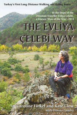
<p style="text-align: justify;"> Deze gids beschrijft een lange afstandsroute van 160 km ten zuiden van Istanbul. De route begint in Altinova en eindigt in Simav.</p> <p style="text-align: justify;"> <span itemprop="description" style="color: rgb(78, 99, 102); font-family: Arial, Verdana, Helvetica, sans-serif; font-size: 13px; line-height: 16px; ">This is the guidebook to Turkey's new long-distance Cultural Route, complete with route description, map, historical background, and places to see. The route follows the Ottoman gentleman adventurer Evliya Celibi on his way to Mecca in 1671; it runs for 600km from the Sea of Marmara via Bursa, Kutahya and Afyon to Usak and Simav. The route follows, as far as possible, ancient paved roads and visits the cities, sights and tiny villages that Evliya rode through and recorded in his "Seyatname" ("Book of Travels"). It can be explored by walkers, horse-riders and bikers. The UN has declared Evliya 'Man of the Year' for 2011, the 400th anniversary of his birth. This route is a practical addition to these celebrations - it enables modern travellers to directly experience Evliya's life, times and travels. It is brought to you by the noted Ottoman historian and author of "Osman's Dream", Caroline Finkel, and the originator of 'The Lycian Way', Kate Clow.</span><span style="color: rgb(78, 99, 102); font-family: Arial, Verdana, Helvetica, sans-serif; font-size: 13px; line-height: 16px; "> </span></p>
€23,95
Bekijk product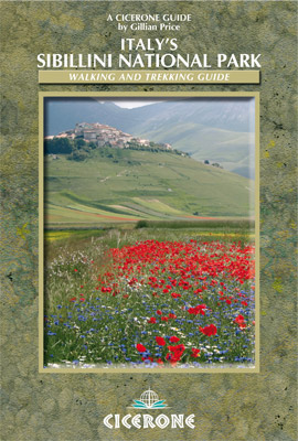
<div> Walking and trekking guidebook to Italy's Sibillini National Park in the Apennines. 21 day walks and an 8-stage multi-day trek, the 120km Grande Anello dei Sibillini are explored alongside sketch maps and plenty of practical information. Easily reached from airports on the Adriatic coast and Rome, the Sibillini straddles the Marche and Umbria.</div> <div> </div> <div> <strong>Seasons Seasons</strong></div> <div> Refuges open from mid-April to mid-October; August and midsummer weekends very busy; higher ridges may have snow until June; excellent winter walking with snowshoes or touring skis, best with a local guide</div> <div> </div> <div> <strong>Centres Centres</strong></div> <div> Amandola, Balzo, Castelluccio, Norcia, Nursia, Preci, Castelsantangelo, Visso, Ancona, Pescara, Perugia</div> <div> </div> <div> <strong>Difficulty Difficulty</strong></div> <div> Something for all abilities, low-level strolls, ridges and walkers' peaks; the GAS requires no mountaineering expertise</div> <div> </div> <div> <strong>Must See Must See</strong></div> <div> The Grande Anello dei Sibillini 8-day trek, Sibillini National Park, Monte Vettore, Monte Sibilla, Piano Grande, Monte Bove</div> <p> </p> <p> <strong>THE GAS – GRANDE ANELLO DEI SIBILLINI</strong></p> <div> Stage 1 Visso to Cupi</div> <div> Stage 2 Cupi to Fiastra</div> <div> Stage 3 Fiastra to Garulla</div> <div> Stage 4 Garulla to Rubbiano</div> <div> Stage 5 Rubbiano to Colle di Montegallo</div> <div> Stage 6 Colle di Montegallo to Colle le Cese</div> <div> Stage 7 Colle le Cese to Campi Vecchio</div> <div> Stage 8 Campi Vecchio to Visso</div> <div> </div> <div> <strong>SHORTER WALKS</strong></div> <div> 1 Valle del Fiastrone</div> <div> 2 Lago del Fiastrone and the Lame Rosse</div> <div> 3 Cascate dell’Acquasanta</div> <div> 4 Bolognola Sentiero Natura</div> <div> 5 Upper Valle dell’Ambro</div> <div> 6 Val di Panico and Pizzo Tre Vescovi</div> <div> 7 Monte Priora</div> <div> 8 The Monte Bove Circuit</div> <div> 9 Gole dell’Infernaccio</div> <div> 10 Monte Sibilla Circuit</div> <div> 11 Monte Porche and Palazzo Borghese</div> <div> 12 Nocelleto to Forca di Gualdo</div> <div> 13 Preci and Sant’Eutizio</div> <div> 14 Monte Patino</div> <div> 15 Foce and Lago di Pilato</div> <div> 16 Castelluccio to Lago di Pilato</div> <div> 17 Monte Vettore</div> <div> 18 Monte delle Rose</div> <div> 19 Castelluccio and the Piano Grande</div> <div> 20 The Dogana Loop</div> <div> 21 I Pantani</div>
€19,95
Bekijk product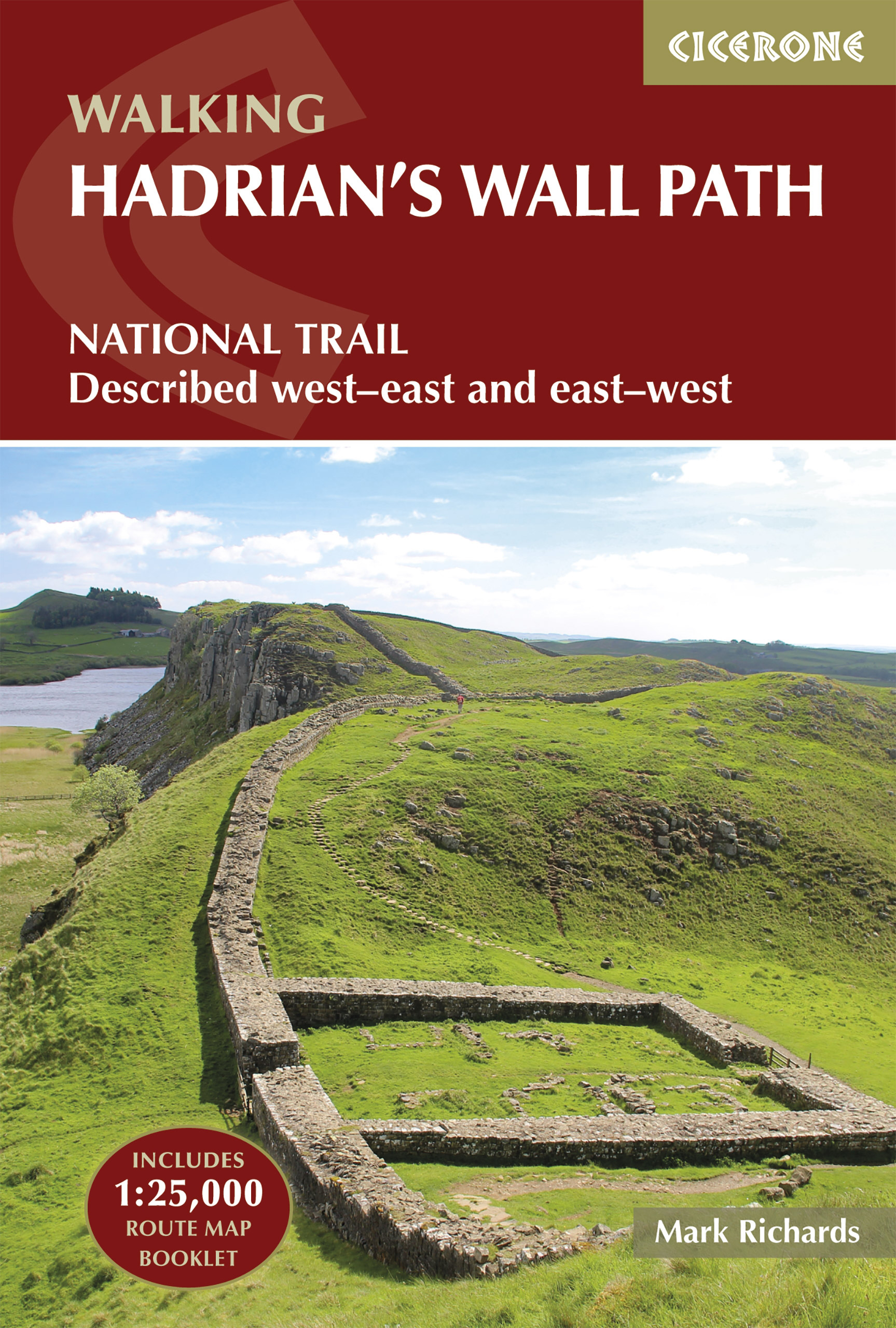
<p> Meest duidelijke wandelgids van de route: veel details in kaarten en informatie, beide kanten op beschreven!</p> <div> The essential guidebook to walking the 84-mile Hadrian’s Wall Path. One of the UK's most visited National Trails, it runs the length of the Roman Wall from Bowness-on-Solway in Cumbria to Wallsend, Newcastle.</div> <div> </div> <div> Begun in AD122 and stretching from the River Tyne to the Solway Firth, Hadrian’s Wall was a massive feat of engineering and is the best preserved frontier from the classical Roman Empire. Today it is a World Heritage Site, with iconic scenery and fascinating archaeological remains like Birdoswald, Housesteads and Vindolanda, giving a glimpse into Roman life and power. The trail is presented here in 10 stages, with suggestions for five and eight-day itineraries. It is suitable for beginners, although a reasonable level of fitness is required if doing it as a multi-day trek. The route is described both west to east and east to west, and the guidebook also features extensions to Maryport on the far west coast of Cumbria and to South Shields on the east coast.</div> <div> </div> <div> This full-colour guidebook contains a wealth of information on the history of the Wall, and a range of practical information for walkers, from accommodation and itinerary planning, to details on public transport and refreshments. Clear step-by-step route descriptions are accompanied by 1:100,000 OS map extracts. A compact booklet showing the route on a 1:25,000 scale OS map is included for added convenience.</div> <div> </div> <div> Seasons</div> <div> Year-round walking, although the useful bus service only operates during the summer months.</div> <div> </div> <div> Centres</div> <div> Bowness-on-Solway, Carlisle, Haltwhistle, Chollerford, Corbridge and Newcastle all make good centres.</div> <div> </div> <div> Difficulty</div> <div> Easy walking. But adequate fitness for a multi-day trek is required for the entire length.</div> <div> </div> <div> Must See</div> <div> The central section of Housesteads and Vindolanda between Chollerford and Haltwistle.</div>
€24,95
Bekijk product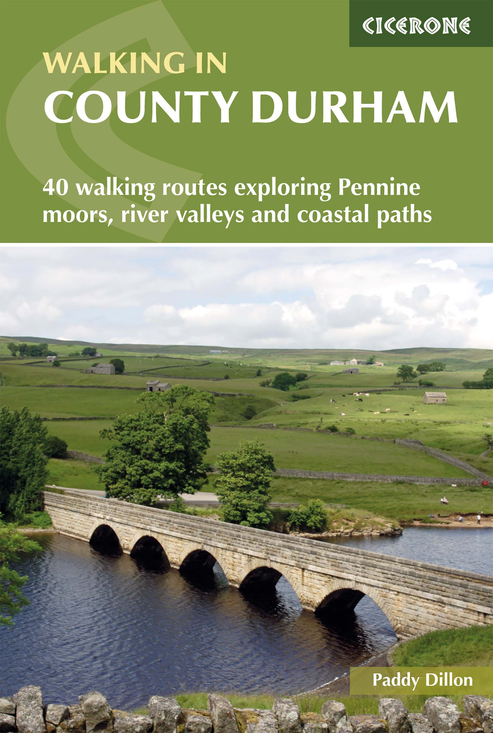
<div> Guidebook of walking routes in County Durham. The 40 day walks, ranging between 5 and 24km in length, explore all corners of this varied county, encompassing wild moorland, rolling pastures, riverbanks and the low cliff coast. With such a range of possibilities, there are walks here for all abilities.</div> <div> </div> <div> They take in highlights such as Beamish, Durham City, Tan Hill and High Force. Featuring 1:50K OS mapping, step-by-step route descriptions, as well as information on the history of the region, the guidebook details everything you need to walk in the region. The county lies between two mighty rivers - the Tyne and the Tees - and between the high Pennines in the west and the North Sea to the east.</div> <div> </div> <div> Into this small space is crammed a wide variety of landscape and two centuries of turbulent history, waiting to be explored on foot</div>
€20,95
Bekijk product
<p> Wandelgids: vele dagtochten worden degelijk beschreven met openbaar vervoer informatie, goede routebeschrijvingen en kaartmateriaal. Tevens enkele autotochten. Deze gids staat goed bekend! Engelstalig, want nederlandstalige is uitverkocht en niet meer leverbaar.</p> <p> 10 car tours, 70 long and short walks, many picnic suggestions</p> <p> The author, who has written several Landscapes guides, found the Corsicans to be the friendliest people he encountered throughout his travels. But the landscapes enchanted him as well: 'No other Mediterranean island can boast such a wealth of natural beauty. Beaches to suit every taste: from long stretches of glaring white sand to pink rocky coves. Real mountains climbers' terrain that reach almost 3000m/9000ft. In these mountains you stumble upon a magnificent mixture of pine forests, beech woods, chestnut groves, and coppices of evergreen oaks. Streams bound down the mountainsides; rivers cascade through awe-inspiring gorges, leaving behind blue-green pools as clear as crystal. The pink granite hills and cliffs, normally conjured up only for an artist's canvas, are real indeed on Corsica.'</p> <p> Best months for walking. In May and June the countryside is enlivened with a tapestry of wild flowers and maquis in bloom. The hills are ablaze with colour and the air is intoxicatingly-scented by the maquis. This is possibly the best time to walk on Corsica, although September and October are also good choices. Incidentally, the island also rewards the walker with fine cuisine at the end of a long day's hiking!</p> <p> Where to Stay. Walks in the book have been written up from four bases: Ajaccio/Porto, Calvi, Bastia and Porto-Vecchio. All are quite well served by public transport. Note: in the peak months of July and August it is essential to have accommodation booked in advance.</p> <p> </p>
€25,95
Bekijk product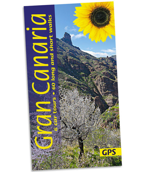
<p> Wandelgids: vele dagtochten worden degelijk beschreven met openbaar vervoer informatie, goede routebeschrijvingen en kaartmateriaal. Tevens enkele autotochten. Deze gids staat goed bekend! Engelstalig, want nederlandstalige is uitverkocht en niet meer leverbaar.</p> <div> 6 car tours, 60 long and short walks, 30 picnic suggestions</div> <div> 150 pages + touring map; plans of Las Palmas, Maspalomas/Playa del Inglés; large-scale (1:50,000) topo maps</div> <div> </div> <div> <div> This new 8th edition has been completely redesigned in a wider format – with larger type and no mapping lost in the gutter. Revised on the ground just a couple of months before publication, the guide also has new topo walking maps with contours at 25m intervals. Based on OpenStreet mapping, the maps now show waypoints, and free downloadable GPS tracks are available for all the walks. Colour coding on the contents page enables you to see at a glance the grading of various walks.</div> </div> <p> </p>
€21,95
Bekijk product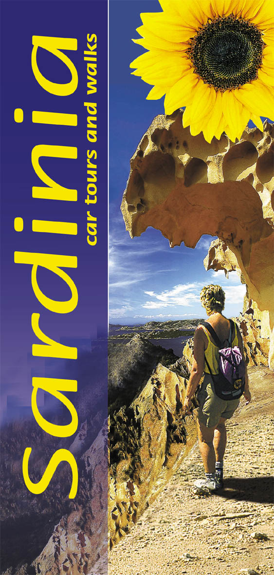
<p> Gids met zowel wandelingen als autotochten.</p> <div> Sardinia, the second largest island in the Mediterranean, is a countryside lover’s paradise. Touring Sardinia by car, you quickly leave all traces of tourism behind: the six car tours cover about 1600km (1000 miles). The tours are arranged in such a way that they can be combined, allowing you to tour round the whole island. As you tour, explore on foot: walking in Sardinia, crushing the fragrant Mediterranean macchia underfoot, will give you the real flavour of the island. Its scenic diversity ranges from rough and primeval landscapes to gentle golden sand dunes, from scorching rocky plateaux and windswept plains reminiscent of Africa to rolling hills with lush pastures and dense brushwood, from towering mountains cloaked in fine oak woods to a turquoise sea that touches the rocky coast. Colourful rock roses and an extravaganza of wild flowers flourish in spring.</div> <div> </div> <div> Area covered: the whole island.</div>
€20,50
Bekijk product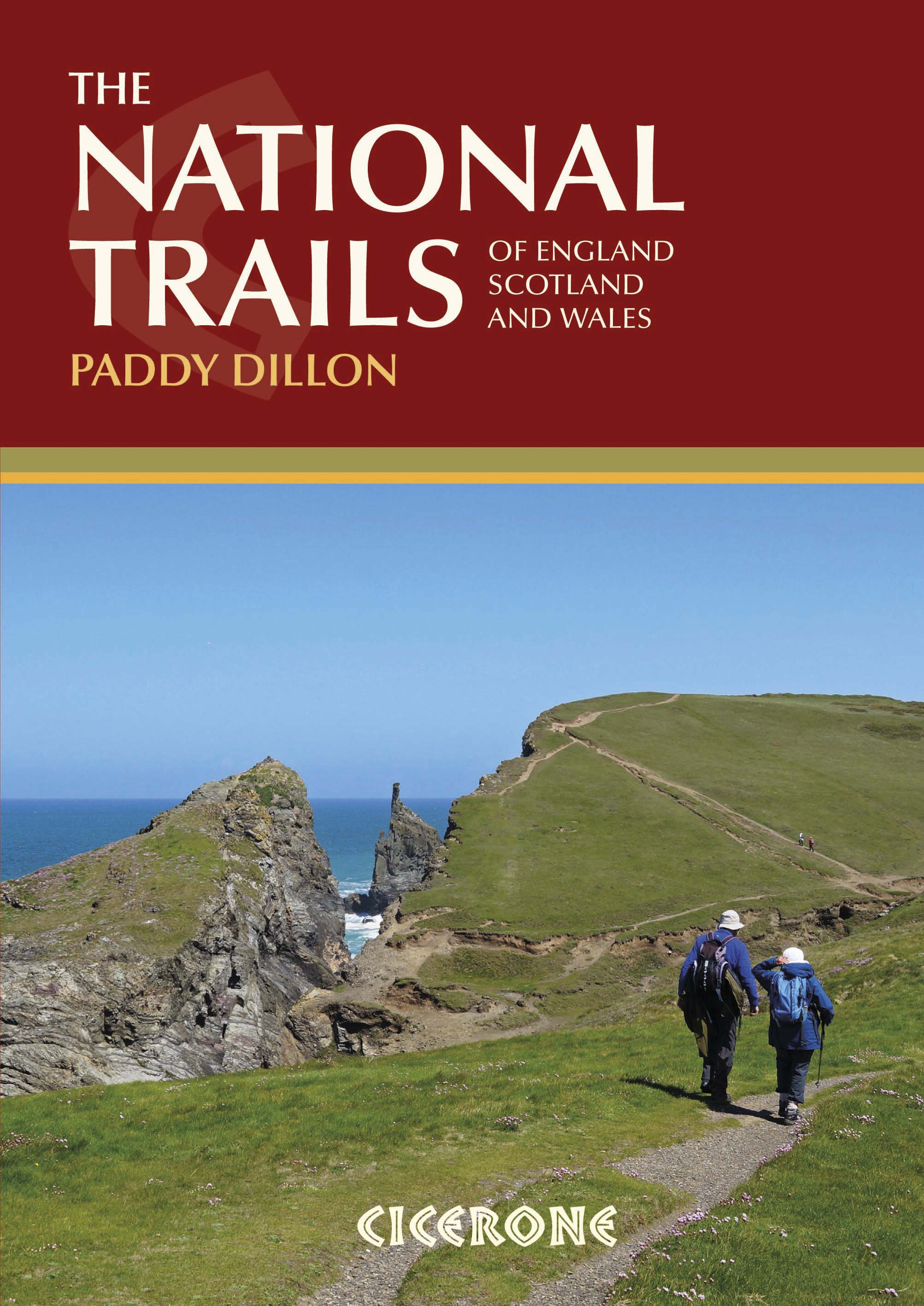
<p> Guidebook to Britain's National Trails - 19 long-distance walking routes through England, Wales and Scotland, describing what makes each of them so special and providing the practical information to help you plan your route. A definitive reference to the best of British walking.</p> <p> England<br /> South West Coast Path<br /> South Downs Way<br /> North Downs Way<br /> The Ridgeway<br /> Thames Path<br /> Cotswold Way<br /> Peddars Way & Norfolk Coast Path<br /> Cleveland Way<br /> Pennine Bridleway<br /> Hadrian's Wall Path</p> <p> Wales<br /> Pembrokeshire Coast Path<br /> Offa's Dyke Path<br /> Glyndwyrs Way</p> <p> Scotland<br /> Southern Upland Way<br /> Speyside Way<br /> West Highland Way<br /> Great Glen Way</p> <p> In 1965 as the first National Trail in the country was opened – ‘a Pennine Way from the Peak to the Cheviots’. Together, the National Trails cover well over 5000 kilometres (3100 miles), exploring the rich, scenic, historic countryside of Britain. Some trails are short and easy, while others are long and challenging. Some have a strong theme, following rugged coastlines or meandering rivers. Others use ancient cross-country routes or follow the courses of ancient boundaries.</p> <p> Packed with information, this guide will help you get out and walk the finest long-distance routes in the country.</p> <p> Outline schedules for each Trail allow you compare the routes and organise your own walking itinerary.<br /> Basic day-by-day route descriptions for each Trail are illustrated with maps and profiles.<br /> For each Trail information is provided on access to and from the route, maps, public transport, guidebooks, TICs, accommodation and useful websites.</p>
€29,50
Bekijk product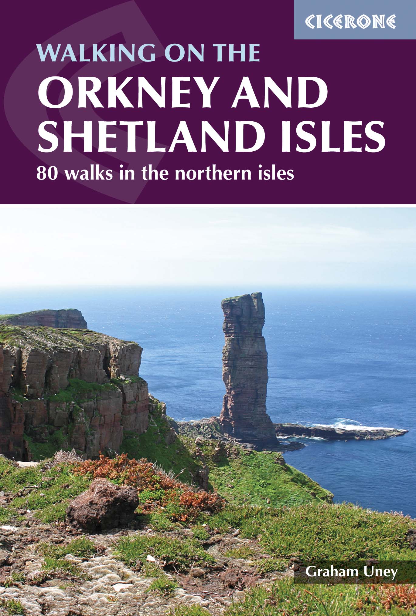
<p> Uitstekende wandelgids van dit geweldige gebied. goed beschreven met veel praktische informatie om de route te kunnen lopen, inclusief redelijke kaarten.</p> <div> A guidebook to 80 walking routes on Scotland's Northern Isles of Orkney and Shetland. Routes are described on the islands of Orkney (Orkney Mainland, Hoy, South Ronaldsay, Burray, Rousay, Eday, Westray, Papa Westray, North Ronaldsay) and the islands of Shetland (Shetland Mainland, West Burra, East Burra, Foula, Fair Isle, Isle of Noss, Bressay, Whalsay, Papa Stour, Muckle Roe, Out Skerries, Esha Ness, Yell, Fetlar and Unst).</div> <div> </div> <div> Routes vary in length from 1 mile to 16 miles, with something to suit all abilities. Offering a variety of landscapes together with a wealth of remarkable archaeological sites such as Skara Brae and Jarlshof, Orkney and Shetland are a walker's dream.</div> <div> </div> <div> Step-by-step route descriptions are accompanied by clear OS mapping and a time estimate for completing each route. The book includes plenty of information on the region's wildlife, archaeology and history, as well as practical tips such as when to go, what to take and getting to and around Orkney and Shetland.</div> <div> </div> <div> Quiet, remote and abounding in rare plants and wildlife, together with some of the world's most fascinating archaeological sites, Orkney and Shetland offer a treasure trove of natural and historic wonders, and makes an ideal walking holiday destination. </div> <div> </div> <div> Dorpen en Steden</div> <div> Sumburgh, Kirkwall, Lerwick, Stromness, Hamnavoe, Scalloway</div>
€22,50
Bekijk product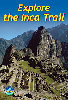
<p> Uitgevoerd in de vorm van een klapper, met ringband geeft deze gids een goede beschrijving van de lange afstands route. De kaarten zijn schetsmatig maar wel duidelijk.</p> <p> This edition of our popular guidebook contains everything you need to plan and enjoy hiking a choice of three Inca Trails to Machu Picchu in Peru. Step-by-step sections cover the Classic trail (4-5 days), the longer, more strenuous trek from Mollepata (6-7 days) and the Shortest option (2 days).</p> <div> This guidebook contains all you need to plan and enjoy trekking the Inca Trail, including</div> <div> </div> <ul> <li> site plan of Machu Picchu ruins</li> <li> description of Machu Picchu, with side-trips and photographs</li> <li> background on Inca culture and stonework, and on modern Peru</li> <li> extended section on Andean wildlife</li> <li> advice on planning and preparation, including packing checklist</li> <li> updated details on recent Trail regulations</li> <li> medical advice on how to prevent and manage altitude symptoms</li> <li> phrasebook in Spanish, Quechua and English</li> <li> drop-down map showing three variants of the Inca Trail</li> <li> in full colour, with 80 photographs</li> <li> on water-resistant paper.</li> </ul>
€19,50
Bekijk product