
Beantwoord enkele vragen, en binnen seconden geeft AI je een persoonlijk aankoopadvies op maat.
Beantwoord enkele vragen, en binnen seconden geeft AI je een persoonlijk aankoopadvies op maat.
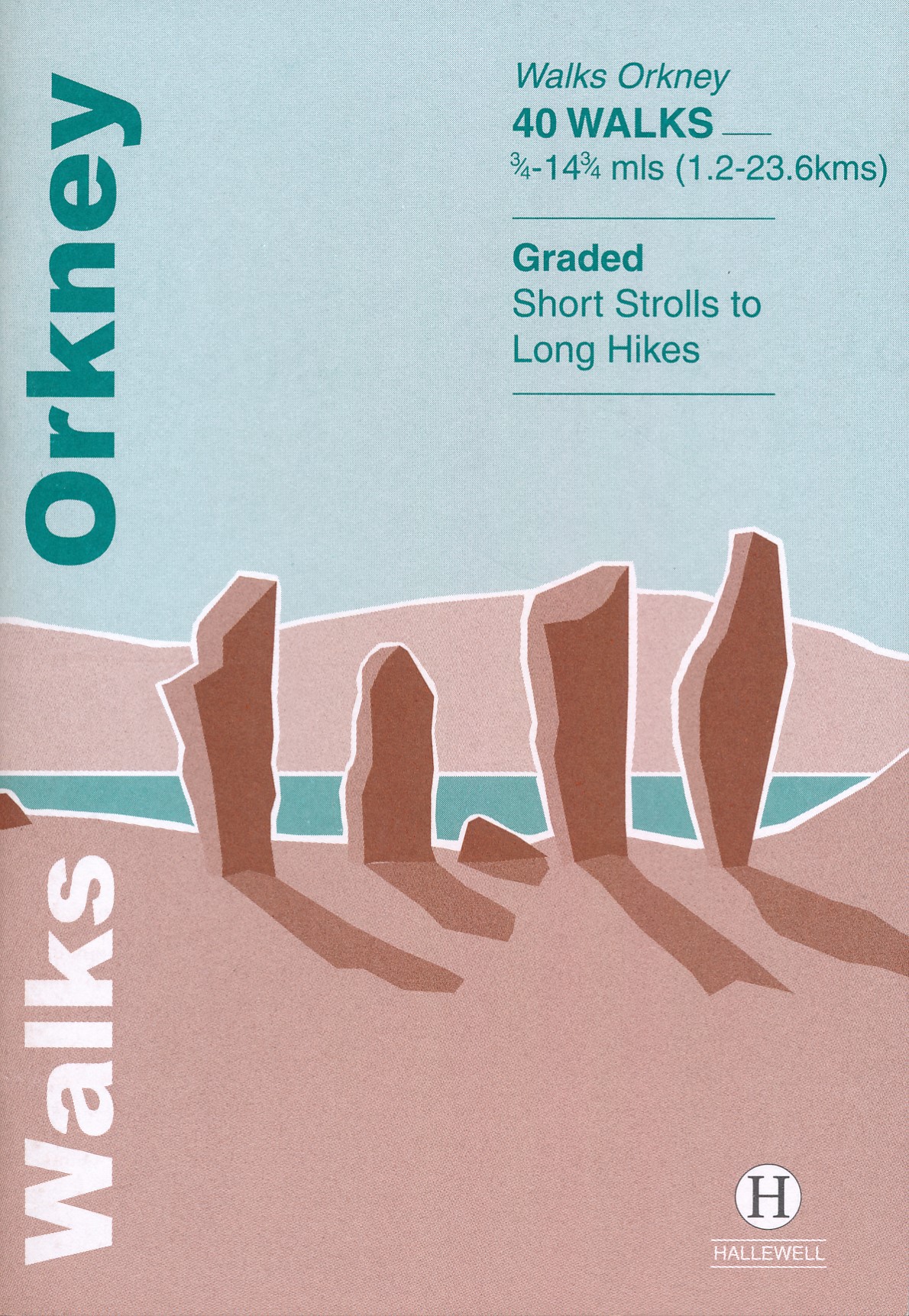
<p> Zeer handzaam gidsje met 40 wandelingen op de Okrneys. Handig als je een paar dagen op elk eiland verblijft. Verwacht geen lange wandelingen, maar je komt zo wel in de buurt van alle hoogtepunten.</p> <p> This guide brings together a selection of the best walks in Orkney. The walks include cliff-top and beach walks, as well as routes through farmland and hill climbs.</p>
€5,95
Bekijk product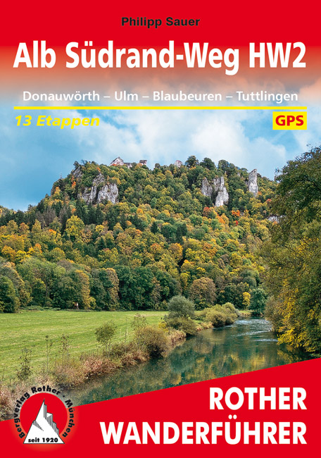
<p> De Rother wandelgidsen beschrijven zeer goed de wandelingen in specifieke gebieden. In de gids vindt men kaarten, routebeschrijvingen en de nodige praktische informatie om van de wandelingen/trekkings een geslaagde onderneming te maken.</p> <p> Idyllische Ortschaften, berühmte Klöster, Burgen und herrliche Natur – das sind die Begleiter des Hauptwanderwegs 2, kurz »HW 2« oder auch »Alb Südrand-Weg« genannt. In 13 Tagesetappen verläuft er entlang des Südrands der Schwäbischen Alb zwischen Donauwörth und Tuttlingen. Aufgrund moderater Steigungen, vor allem aber aufgrund überragender kultureller Highlights ist er ein wahrer Genussweg. Der Rother Wanderführer »Alb Südrand-Weg« beschreibt diesen Weitwanderweg mit allen wichtigen Informationen.</p> <p> Der über 111 Jahre alte, fast 300 Kilometer lange »HW 2« hat geringere Höhenunterschiede als sein berühmter Zwilling, der »Albsteig« oder auch »HW 1«, der den Albtrauf im Norden erschließt. Dafür bietet der »HW 2« auf der sanfteren Donauseite außerordentliche kulturelle Glanzpunkte: Die Wanderung führt durch die ehemalige Reichsstadt Ulm mit Münster, Rathaus und mittelalterlichen Bauwerken, durch Blaubeuren mit Kloster und dem tiefblauen Blautopf, durch das Große Lautertal und das fulminante, weithin bekannte Felsental der Oberen Donau zwischen Sigmaringen und Mühlheim, um nur einige zu nennen. Auf dem Südrand-Weg wird die Alb in ihrer ganzen Vielseitigkeit erlebt – mal steil und felsig, mal romantisch und lieblich, mal bescheiden und natürlich. </p> <p> Übersichtlich und zuverlässig liefert der Rother Wanderführer alle Infos, die man als Weitwanderer braucht: genaue Wegbeschreibungen, aussagekräftige Höhenprofile und detaillierte Karten mit Routeneintrag. Dazu kommen viele Infos zu Unterkünften und Einkehrmöglichkeiten. Die GPS-Tracks stehen zum Download von der Internetseite des Bergverlag Rother bereit.</p>
€15,50
Bekijk product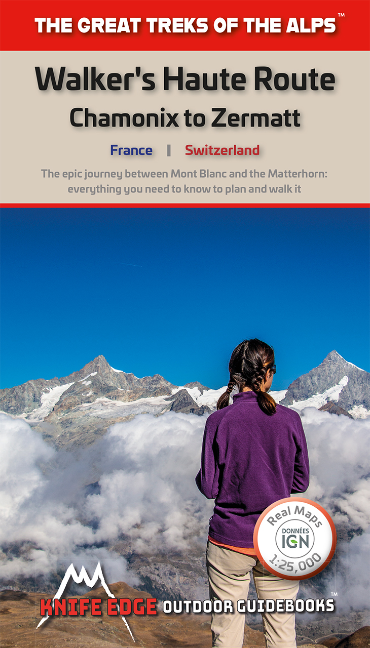
<p> Overzichtelijke routegids van deze prachtige wandelroute. Per etappe vind je een hoogteprofiel, goede beschrijvingen van de wandelroute, een topografische kaart op gedetailleerde schaal. Voor en achterin de gids staat aanvullende praktische informatie zoals adressen van campings, andere accommodaties en bijvoorbeeld een paar pagina's over de flora en fauna. </p> <p> The only guidebook for the Walker's Haute Route with Real Maps: 1:25,000/1:50,000 mapping included for each stage. This makes navigation easy and saves you money: no need to buy additional maps. Also includes:* Unique Itinerary Planner: plan a bespoke itinerary to match your ability and vacation schedule. All difficult calculations of time, distance and altitude gain are done for you* 6 Proposed Itineraries of between 10 and 14 days* Everything the trekker needs to know to plan the route: route descriptions, costs, budget, difficulty, weather, how to get there, and more* Full accommodation listings: spectacularly situated mountain huts, villages and hamlets* Complete list of every camping location, including free campsites* Section on Zermatt day walks* 13 exciting variants to the main route* Information for both self-guided and guided trekkers* Edge to edge colour: the most modern and beautiful TMB guidebook</p> <p> The Walker's Haute Route is an incredible trek between the two most famous mountain towns in the Alps. Travelling from Chamonix in France to Zermatt in Switzerland, you will start at Mont Blanc and finish at the Matterhorn. On the way, pass the largest collection of snowy 4000m summits in the Alps: Mont Blanc, Grand Combin, the Weisshorn, the Zinalrothorn, the Dom, the Täschhorn, the Breithorn and the Matterhorn, to name a few. The sister trek to the Tour du Mont Blanc crosses unspoilt and remote mountain terrain: amazing glaciers, snow frosted summits, beautiful valleys and pastures, shimmering lakes, carpets of wild flowers and the soothing sound of cow bells. This trek should be on your hiking bucket list.* 206km * 10-14 days* 14,000m of altitude gain * 12 mountain passes * 2 countries, France and Switzerland</p>
€20,95
Bekijk product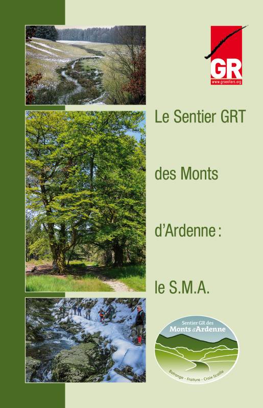
<p> Alhoewel we in onze Ardennen geen "bergen" kennen in de echte zin van het woord, kan het er toch aardig op en neer gaan. Heel wat "bergwandelaars" trekken regelmatig Wallonië in om er langs GR-routes met een- of meerdaagse tochten hun conditie aan te scherpen. Dagtochten met 500+ hoogtemeters zijn er geen uitzondering.</p> <p> De Ardennen zijn dan ook het ideale oefenterrein voor de liefhebbers van bergtochten. Vandaar ook het idee om de 3 hoogste toppen van het Ardennenmassief te verbinden via de bestaande GR-paden.Het Ardense Bergenpad (Sentier des Monts d'Ardenne - SMA) slingert zich over 225 km van het Signal de Botrange in het oosten van de provincie Luik, naar de Baraque Fraiture in het noorden van de provincie Luxemburg, en verder naar het Croix Scaille in het zuiden van de provincie Namen.</p> <p> Na het Trappistenpad (Sentier des Abbayes Trappistes) is het SMA het tweede thematische GR-pad dat de Ardennen doorkruist. Het pad maakt hoofdzakelijk gebruik van bestaande GR-paden. Komen aan bod: GR 573 / GR 56 / GR 14 / GR 151 /GR 577 / GR 129 en GR 126.Tijdens het volledige traject wordt 6600 m gestegen en 6700 m gedaald. Het hoogteverschil tussen het hoogste en het laagste punt op het traject bedraagt bijna 550 m. Het zijn nog altijd geen Alpijnse cijfers, maar om de SMA te overwinnen zal je toch menige kuitenbijter moeten trotseren.Deze gids is Franstalig</p>
€19,95
Bekijk product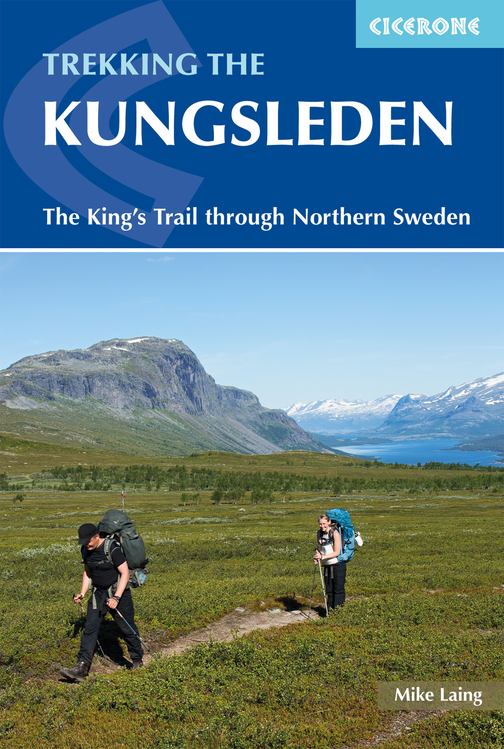
<p> Sweden's most famous long-distance trail, the Kungsleden (King's Trail) traverses the land of the Sámi people and the midnight sun, stretching 460km between Abisko and Hemavan. Around half the route lies within the Arctic Circle showcasing an ever-changing landscape of snowy mountains, deep glacial valleys, open fell, expansive lakes and verdant forest. The fully waymarked trail is comprised of five continuous and distinct sections: these can be walked individually or a thru-hike will take around a month. The guide also includes the popular Abisko to Nikkaluokta circuit, which can be completed in a week, and an ascent of Kebnekaise, Sweden's highest peak at 2098m.<br /> <br /> In addition to clear route description and mapping, you'll find a wealth of practical advice covering accommodation and facilities, equipment and resupply and detailed notes on how to get to and from the section start and finish-points. A Swedish and Fell Sámi glossary can be found in the appendix. Although there are plentiful opportunities for wild camping, three of the five trail sections are equipped with huts (many including a shop and a sauna) making them easily accessible to all. The remaining two sections have a more remote feel that will appeal to those intent on finding some solitude. To add further colour, there are seven mandatory lake crossings on the trail with the option of rowing or using the motorised service: full details are provided in the text.<br /> <br /> The Kungsleden passes through five national parks, including Sarek. Other highlights include the striking Tjäktjavagge glacial valley and the famous hay meadows of Aktse, perfectly framed by the azure Lájtávrre delta and the sheer chiselled face of Skierrffe. The Kungsleden invites you to step into a new world, and it may well prove to be the start of a long and rich association involving many repeated visits.</p> <p> Steden en Dorpen</p> <p> Abisko, Kebnekaise Fjällstation, Nikkaluokta, Saltoluokta, Kvikkjokk, Jäkkvik, Adolfsström, Bäverholmen, Ammarnäs, Hemavan</p>
€24,95
Bekijk product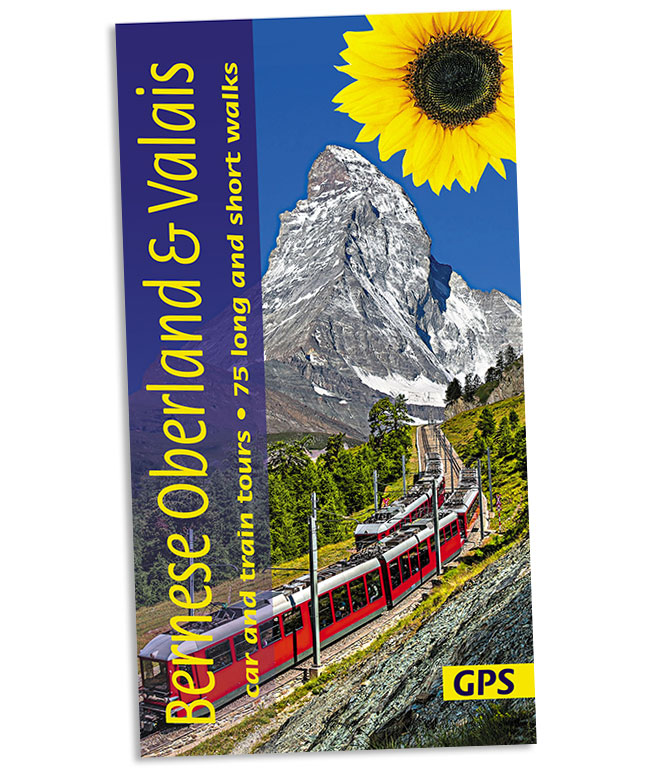
<p> Wandelgids: vele dagtochten worden degelijk beschreven met openbaar vervoer informatie, goede routebeschrijvingen en kaartmateriaal. Tevens enkele autotochten. Deze gids staat goed bekend! </p> <p> This new guide – in Sunflower’s new, wider format – covers the most popular destinations in western Switzerland, countryside blessed with a most dramatic and spectacular landscape. Mountains, glaciers, lakes, rivers, gorges, and waterfalls are plentiful natural elements into which cultural influences blend.</p> <div> Although a car is the best way to explore much of the Oberland and Valais, Switzerland boasts the world’s best public transport system. You can see a vast majority of its mountain landscapes by public transport. There are many suggested train tours in the guide. But where trains don’t go, buses will – even to remote valleys and hamlets.</div> <div> </div> <div> Switzerland is a hiker’s paradise (you would expect nothing less of a country which has an article in its constitution regulating the responsibilities of those who maintain the thousands of kilometres of hiking paths!).</div> <div> </div> <div> Mountain huts and comfortable hotels sit atop summits reached by spectacular train or cable car rides, but there is still plenty of space where you will hardly meet a soul.</div> <div> </div> <div> The author, who lives in the area and has written several guides for walkers, caters for all abilities – from gentle strolls through the wine villages of the Valais to more strenuous hikes beside the north face of the Eiger or alongside the largest glacier in the Alps.</div> <div> </div> <div> Information ‘boxes’ add interest to the book – whether describing grape varieties and harvesting methods or the engineering feats of the country’s dams and irrigation channels.</div> <div> </div> <div> There are three main car tours, with dozens of side excursions. A map accompanies each car tour, but there are also two pull-out touring maps covering the whole of western Switzerland.) Of course, there are many suggestions for train, funicular and cable car rides, as well as 75 long and short walks (some of which are specially tailored to motorists). All the main walks are illustrated with 1:50,000 topo maps and free GPS tracks are available from this website.</div> <div> </div> <div> Area covered: This guide covers all of the Bernese Oberland and Valais.</div>
€20,95
Bekijk product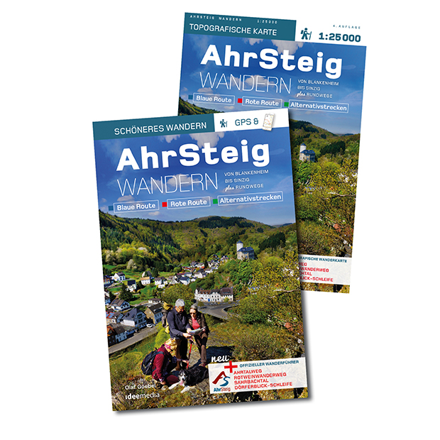
<p> Set met een handige wandelgids en gedetailleerde kaart.</p> <p> Rund 110 traumhafte Kilometer windet sich der neue AhrSteig von der Quelle in einem historischen Fachwerkhaus in Blankenheim bis zur Mündung in den Rhein bei Sinzig. Ahr-Kenner Olaf Goebel beschreibt detailliert alle Halb- und Ganztagesetappen auf einer traumhaften Wandertour durch Deutschlands Rotweinparadies. Die Karte im Maßstab von 1: 25 000 erleichtert an allen Wegpunkten die Orientierung.</p> <div> Alles, was Wanderer im Ahrtal benötigen, enthält das günstige Set: Buch, App, Karte, GPS-Daten – und Tipps für die schönsten Kombi-Touren und Rundwege in Verbindung mit dem Rotweinwanderweg. Zwischen Wäldern und Weinbergen führt der neue Premiumwanderweg jetzt auf finaler Trasse über weite Höhen und tiefe Täler mitten ins Herz des deutschen Rotwein-Anbaus. Auf den insgesamt rund 110 Kilometern, die in einfachen bis mittelschweren Tagesetappen zu bewältigen sind, liegen malerische Weinbaudörfer.</div> <div> </div> <div> Wanderbuch-Autor Olaf Goebel kennt das Ahrtal und seine Geheimtipps wie seine Westentasche – er war viele Jahre Leitender Redakteur der Regionalredaktion Bad Neuenahr-Ahrweiler. Von Blankenheim aus führt die neue Route über den Ahrtalweg zum Freilinger See und über die alte Römerstraße nach Eichenbach.</div> <div> </div> <div> Bei Schuld erwartet die Wanderer ein traumhafter Blick auf die Ahrschleife, bevor es am Fluss entlang und über schmale Pfade nach Sierscheid, Dümpelhard und Liers geht. Mythen und Sagen begleiten die AhrSteiger auf ihrem weiteren Weg nach Ahrbrück und zum Hexenrichtplatz von Pützfeld. Herrliche Ausblicke über das Rotweindorf Mayschoss gibt es von der Saffenburg. Die neue Königsetappe führt durch das wilde Tal der Ahr und verbindet Kreuzberg mit Walporzheim. Vorbei an der Lourdeskapelle und über den Neuenahrer Berg geht es zum Idienbachtal, bevor im romantischen Ahrdorf Heimersheim der Endspurt für die letzte Etappe zum Schloss nach Sinzig und zur Rheinmündung beginnt. Eigens ermittelte und geprüfte GPS-Daten, Detailkarten und übersichtliche Infoteile sowie Empfehlungen für Einkehr und Übernachtung runden das Informationsangebot ab. Im Set enthalten ist außerdem die aktuellste großformatige Wanderkarte im Maßstab 1: 25 000. Und wer vom AhrSteig noch nicht genug hat, der kann zusätzlich den Rotweinwanderweg, die Sahrbachtal- und Dörferblick-Schleife erkunden.</div> <div> </div> <div> Insgesamt ergeben sich so 233 Kilometer Wanderspaß im Rotweinparadies.</div> <div> </div> <div> Besonders einfach wird es unterwegs für diejenigen, die die kostenlose App „traumtouren“ geladen haben: Via QR-Code im Buch lassen sich alle Etappen unkompliziert und kinderleicht auf Smartphones und Tablets laden.</div>
€21,50
Bekijk product
<div> De ware wandelliefhebber geeft de voorkeur aan het lopen over gras, half- tot onverhard. In het westen van het land waren de mogelijkheden daarvoor tot voor kort schaars. Maar juist de afgelopen jaren zijn er veel 'zachte' voetpaden bijgekomen, dankzij de medewerking van boeren, waterschappen en gemeenten. De meeste van die paden zijn opgenomen in de regionale wandelnetwerken van Utrecht, Noord- en Zuid-Holland.</div> <div> </div> <div> Anno 2018 is het overgrote deel van die provincies bedekt met een fijnmazig netwerk van uniform bewegwijzerde wandelroutes. De wandelaar kan z'n eigen route uitzoeken aan de hand van allerlei criteria: lang-kort, met of zonder hond, bossig of open, verhard of onverhard, thematisch of niet-thematisch. Maar waar te beginnen als wandelaar? Waar is het nu 'echt genieten', wat zijn de mooiste rondwandelingen?</div> <div> </div> <div> De auteurs, routemakers en ontwerpers van diverse wandelnetwerken, weten dat als geen ander. Daarom hebben ze het initiatief genomen om een nieuwe serie gidsen te starten. Op basis van eigen ervaringen hebben ze de leukste wandelrondjes en lijnwandelingen geselecteerd. Het resultaat is gebundeld in gidsjes per regio met steeds 15 wandelpareltjes van tussen de 5 en 15 km, waarvan minstens 50% uit half- of onverharde paden bestaat.</div> <div> </div> <div> De routes zijn zo beschreven, in kaart en beeld gebracht dat de lezer er zin in krijgt, dat hij ook te voet de polder in wil. De liefde voor het wandelen spat er vanaf. Een grote inspiratiebron vormde de gidsenserie Lopen over gras van Jouke van der Meij en Kees ten Holt (†) uit de jaren 1980. Zakgidsjes met liefde gemaakt naar Engels voorbeeld: met getekende kaartjes en sfeervolle schetsjes van landschappen.</div> <div> </div> <div> Er is voor een compact formaat gekozen. Groot verschil met vroeger is het gebruik van kleuren en van topografische kaartjes. Voor de kleurstelling en de plaatsnamen op die kaartjes is gekeken naar stafkaarten van rond 1900 - in retrostijl dus. Naast eigen foto's hebben de auteurs historische plaatjes en kaartjes opgenomen. Ook dat is een verschil, evenals het ontbreken van routebeschrijvingen: ze geven alleen de nummers van de te volgen knooppunten en de kleuren van de richtingpijlen.</div>
€16,99
Bekijk product
<p> Uitstekende wandelgids van de Cambrian Way, waarbij naast alle noodzakelijke informatie ook gebruik gemaakt wordt van de echte topografische kaart. </p> <div> Dubbed 'the mountain connoisseurs' walk', the Cambrian Way stretches 479km between the mighty castles of Cardiff in the south and Conwy on the north coast. Traversing the heartland of Wales, the challenging route crosses the Brecon Beacons, the Cambrian Mountains and Snowdonia, passing through two national parks and visiting many of the country's iconic summits, including Pen y Fan, Pumlumon, Cadair Idris and Snowdon itself. It can be walked in three weeks (or in shorter sections) and is suitable for experienced hillwalkers with sound navigational skills.</div> <div> </div> <div> The guide presents the route in 21 stages, offering comprehensive route description illustrated with OS 1:50,000 mapping and elevation profiles. Details of accommodation and facilities are provided, along with a helpful trek planner showing their distribution along the route: although the trail passes through remote areas, it is possible to stay under a roof every night – though camping is also a possibility, should you prefer. There are background notes on Wales's history and geology and local points of interest, and a glossary of Welsh place-names, useful contacts and accommodation listings can be found in the appendices.</div> <div> </div> <div> From the Black Mountains to the Rhinogs, Glyderau and Carneddau, the route takes in lofty ridges, striking peaks and picturesque lakes. There are also fascinating glimpses into the country's ancient and more recent past: Iron Age hillforts, Norman castles, a Cistercian abbey, the Chartist Cave and relics from the mining industry. Offering superlative scenery, the Cambrian Way is a celebration of some of the best mountain walking Wales has to offer and promises a unique opportunity to immerse yourself in these celebrated landscapes.</div> <div> </div> <div> Steden en Dorpen</div> <div> Cardiff, Pontypool, Abergavenny, Crickhowell, Llandovery, Strata Florida, Devil's Bridge, Ponterwyd, Dinas Mawddwy, Barmouth, Beddgelert, Pen-y-Pass, Ogwen, Conwy</div>
€20,95
Bekijk product
<p> <span style="font-family: "Helvetica Neue", Helvetica, sans-serif, Arial;">Franstalige wandelgids met 100 dagwandelingen verspreid over een groot gebied in de Pyreneeën en ten noorden daarvan. Goede kaarten en duidelijke informatie over de wandelingen.</span></p> <div> Le territoire concerné </div> <div> • Département de l’Ariège</div> <div> • Département de l’Aveyron</div> <div> • Département de la Haute-Garonne</div> <div> • Département du Gers</div> <div> • Département du Lot</div> <div> • Département des Hautes-Pyrénées</div> <div> • Département du Tarn</div> <div> • Département du Tarn-et-Garonne</div> <div> Le guide</div> <div> • 100 itinéraires de 1h45 et 7h00</div> <div> • Cartographie sur fond IGN au 1 : 25 000 pour se repérer facilement</div> <div> • Détail des centres d’intérêts</div> <p> </p> <div> • Renseignements pratiques et adresses utiles.</div>
€21,50
Bekijk product