
Beantwoord enkele vragen, en binnen seconden geeft AI je een persoonlijk aankoopadvies op maat.
Beantwoord enkele vragen, en binnen seconden geeft AI je een persoonlijk aankoopadvies op maat.
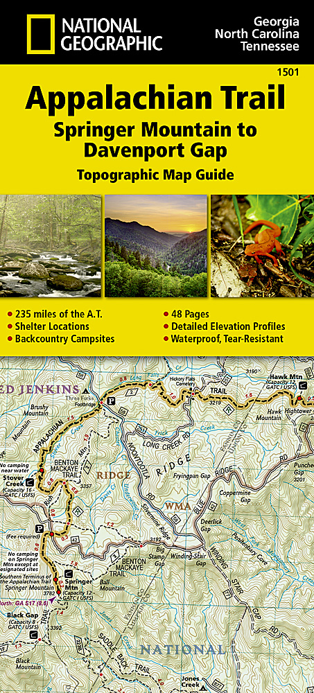
<div> Wandelgids/wandelatlas met weinig tekst, maar goede kaarten van een gedeelte van de Appalachian Trail. </div> <div> </div> <div> The Springer Mountain to Davenport Gap Topographic Map Guide makes a perfect traveling companion when traversing the Georgia, southeastern Tennessee and southwestern North Carolina, section of the Appalachian Trail (A.T.). The southern most section of the A.T. which starts at Georgia's Springer Mountain and heads north into North Carolina and Tennessee, offers some of most physically challenging, but rewarding hiking along the entire trail. The A.T. through this area is located entirely within National Park and National Forest land, and follows the ridges and balds of the beautiful and biologically diverse Southern Appalachians.</div> <div> </div> <div> Each A.T. Topographic Map Guide includes detailed topographic maps at a detail of 1 inch = 1 mile. Each page is centered on the A.T. and overlaps with the adjacent pages so there is little chance of getting lost. Along the bottom of each page is a trail profile that shows the distance between shelters, camping areas, and trail access points. The map and trail profile provide a step by step visual guide to hiking the trail, mile by rugged mile. The Topographic Map Guide is built for all levels of hiking enthusiasts, from the day tripper to the multi month 'thru-hiker'. The front pages of the printed Topographic Map Guide include resupply information, town inset maps, camping options, and much more.</div>
€16,95
Bekijk product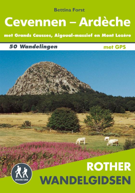
<div> De Rother wandelgids Cevennen-Ardèche beschrijft 50 wandelingen in deze populaire regio's in Frankrijk. Met Grand Causses, het Aigoual-massief en Mont Lozère.</div> <div> </div> <div> Zoals gebruikelijk zijn er verschillende wandelingen voor beginnende en ervaren wandelaars en is er onmisbare informatie over de streek, de bezienswaardigheden en recreatiemogelijkheden.</div> <div> </div> <div> De betrouwbare routebeschrijvingen, gedetailleerde kaarten en hoogteprofielen zorgen voor een onvergetelijke wandelervaring.</div> <div> </div> <div> Let op: er is enige verwarring omtrent het jaartal van deze Nederlandse wandelgidsen van uitgever Elmar. Dit is een vertaling van de Duitse uitgever Rother maar daarna NIET bijgewerkt. De datum die wij vermelden is het moment van vertaling; er zijn andere – meer recente jaartallen – in omloop maar dat is de datum van een nieuwe druk ZONDER aanpassingen. Wilt u de meest recente wandelgids van dit gebied van deze uitgever: kies dan de Duitstalige versie van uitgever Rother. Deze zijn recent en WEL bijgewerkt. </div>
€18,99
Bekijk product
<p> Wandelgids van een deel van Wales. Deze gids bevat 20 wandelingen, geschikt voor de hele familie. De bijbehorende kaarten zijn uitstekend: men heeft de topografische kaarten van Ordnance Survey gebruikt waarop de route is ingetekend. Daarnaast praktische informatie over de wandeling en wat beschrijvingen van het gebied.</p> <p> The Snowdonia short walks guidebook is ideal for all the family. Containing 20 splendid short walks ranging from 2 to 6 miles, this guide is perfect for newcomers to country walking and those that prefer gentler rambling.</p> <div> The mountains of Snowdonia are magnificent featuring row-upon-row of jagged peaks and ridges; However, there is more to Snowdonia than its mountains. The region offers the walker plenty of easy low-level walks through delightful valleys ranging from narrow and steep-sided to green and open.</div> <div> </div> <div> The walks in this guide take in some of Snowdonia’s most famous features – castles, lakes, legends, forests, valleys and waterfalls. The only walk featured that does visit the top of Snowdon does so by means of the Snowdon Mountain Railway – leaving the walker free to enjoy a pleasant descent to Llanberis after enjoying the mountain view.</div> <div> </div> <div> This book contains 20 circular walks all graded by route and difficulty, they can be enjoyed by the whole family and are the ideal companion for day trips and holidays.</div>
€11,50
Bekijk product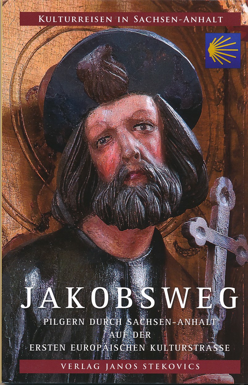
<p> uitgebreide beschrijving van de Jacobsroute in Sachsen-anhalt met redelijke kaarten in de gids aanwezig.</p> <p> Pilgern durch Sachsen-Anhalt auf der ersten europäischen Kulturstraße</p>
€16,95
Bekijk product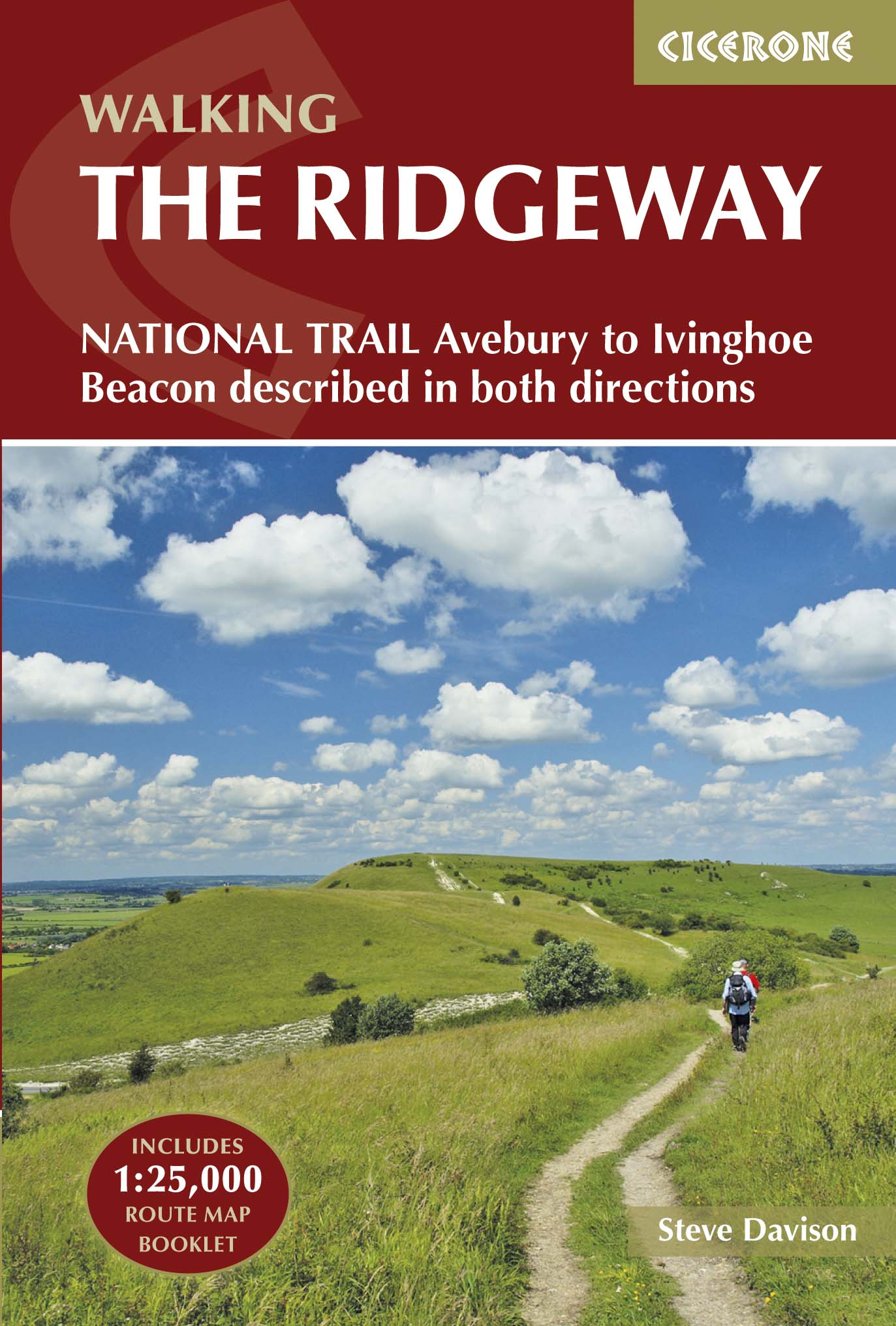
<div> Uitstekende wandelgids van de Ridgeway, waarbij naast alle noodzakelijke informatie ook gebruik gemaakt wordt van de echte topografische kaart. Inclusief gidsje met routekaarten van 1:25000</div> <div> </div> <div> This guidebook - which includes both a guide to the route and a separate OS map booklet - describes the Ridgeway National Trail, an 87 mile (139km) route through southern England from Avebury in Wiltshire to Ivinghoe Beacon in Buckinghamshire. Typically walked in 6 or 8 days, this is a low-level waymarked route suitable for all abilities and for year round walking.</div> <div> </div> <div> The guidebook details the trail in both directions, west to east and east to west. Step-by-step route descriptions are accompanied by 1:100,000 OS mapping and a separate OS 1:25,000 map booklet showing the entire route is included. Packed with details on points of interest and a trek planner giving at-a-glance information about facilities, public transport and accommodation available along the way, this book is an indispensable guide to walking this national trail.</div> <div> </div> <div> Following a ridge of chalk hills through the Chiltern Hills AONB and North Wessex Downs AONB, the Ridgeway takes walkers through five counties and five thousand years of history. It offers a scenic and fascinating journey through our ancient and more recent past, visiting the UNESCO World Heritage Site of Avebury's Neolithic stone circle and the famous Uffington White Horse, and includes excursions to picturesque villages, thatched cottages and cosy pubs.</div>
€23,95
Bekijk product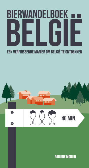
<div> Liefhebbers van lekker bier en mooie wandelingen: deze gids is voor jullie!</div> <div> </div> <div> De 40 wandelingen in dit boek zijn geselecteerd omwille van hun mooie setting maar ook (en niet in het minst) omwille van hun eindpunt: elke wandeling leidt je naar een brouwerij of café waar je van een goed glas bier kunt genieten.</div> <div> </div> <div> Bij elke wandelroute krijg je gedetailleerde aanwijzingen: de moeilijkheidsgraad, de duur, de hoogteverschillen, de bezienswaardigheden onderweg, hoe je er geraakt met het openbaar vervoer… Aan het einde van elke route wordt een lokale brouwerij of een authentiek café voorgesteld, en raadt de auteur een bier aan.</div> <div> </div> <ul> <li> EEN NIEUWE REDEN OM OP WANDELTOCHT TE VERTREKKEN</li> <li> WANDEL, PROEF, EN STEUN DE MICROBROUWERIJEN</li> <li> OOK GESCHIKT VOOR WANDELAARS DIE LIEVER EEN THEETJE DRINKEN</li> <li> MET GPX-FILES OM TE DOWNLOADEN</li> </ul>
€24,95
Bekijk product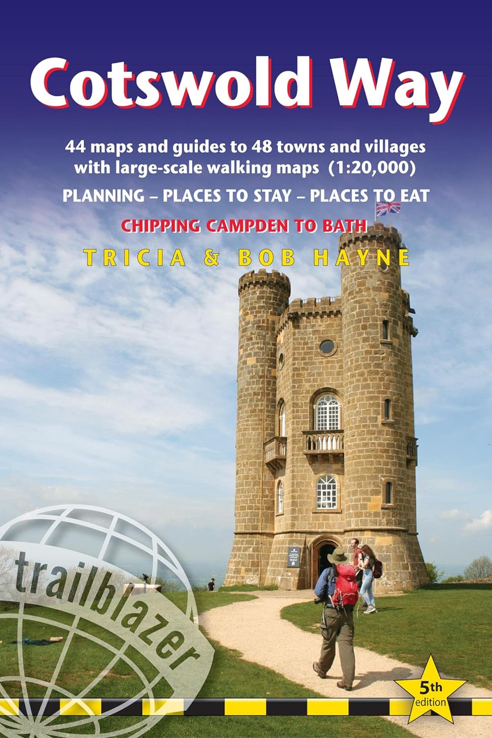
<p> Goede wandelgids van de hele route van Chipping Campden naar Bath. Met veel details zijn alle etappes beschreven. Tevens informatie over overnachtingen en openbaar vervoer.</p> <div> All-in-one hiking route guide and maps for the Cotswold Way, a 102-mile National Trail that runs from Chipping Campden to Bath, following the beautiful Cotswold escarpment, this is the fully revised and updated 4th edition. The trail leads through quintessentially English countryside with little villages of honey-coloured stone to the well-known town of Bath. Includes:</div> <div> </div> <div> * 44 large-scale maps at just under 1:20,000 (3 1/8 inches to 1 mile) - showing route times, places to stay, points of interest and much more and trail profiles;</div> <div> </div> <div> * 8 town plans - Chipping Campden, Broadway, Winchcombe, Cheltenham, Painswick, Dursley, Wotton-under-Edge, and the city of Bath and 8 overview maps.</div> <div> </div> <div> * Full details of all accommodations and campsites, teashops, restaurants and pubs with reviews.</div> <div> </div> <div> * Itineraries for all walkers - whether walking the route in its entirety over seven to eight days or sampling the highlights on day walks and short breaks.</div> <div> </div> <div> * Practical information for all budgets: where to eat, what to see.</div> <div> </div> <div> * Comprehensive public transport information - for all access points on the Cotswold Way.</div> <div> </div> <div> * Flora and fauna - four page full colour flower guide plus an illustrated section on local wildlife.</div> <div> </div> <div> * Green hiking - understanding the local environment and minimizing our impact on it.</div> <div> </div> <div> * Bath city guide.</div> <div> </div> <div> * Downloadable gps waypoints.</div>
€21,95
Bekijk product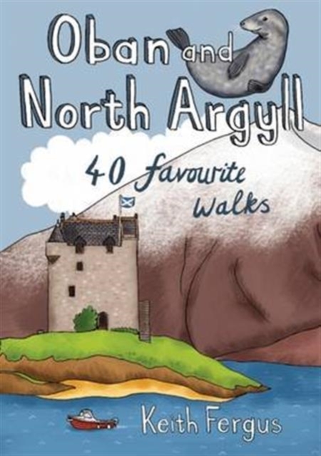
<p> This guidebook covers a large swathe of Mid and North Argyll, sweeping inland from the fractured western seaboard between Crinan and Appin to Arrochar and Bridge of Orchy on the region’s eastern periphery. Between these four points lies a landscape awash with sea lochs, with Inveraray roughly at the geographical centre. There are no large urban areas here and Oban is the largest settlement. Although the road network and public transport infrastructure are good, many routes feel off the beaten track. This is not only down to the low scattered population but also to the indented coast and its many islands, the sea lochs encroaching deep inland, the elongated freshwater lochs and the mountainous interior – making road travel much more convoluted than direct ‘as-the-crow-flies’ distances would suggest.</p> <p> As well as many great sea lochs, tumbling rivers and iconic mountains, Oban and North Argyll also boasts ancient, wildlife-rich woodlands and several fine gardens. Add to this the Crinan Canal, often described as 'the most beautiful shortcut in Scotland', and some of the most important historical and archaeological sites in the country and you have all the makings of a fascinating walking destination.From the harbourside bustle of Oban to the ancient peace of Kilmartin Glen, this guide features 40 walks over varied landscapes that take in the very best the 'Coastland of the Gaels' has to offer.</p>
€10,95
Bekijk product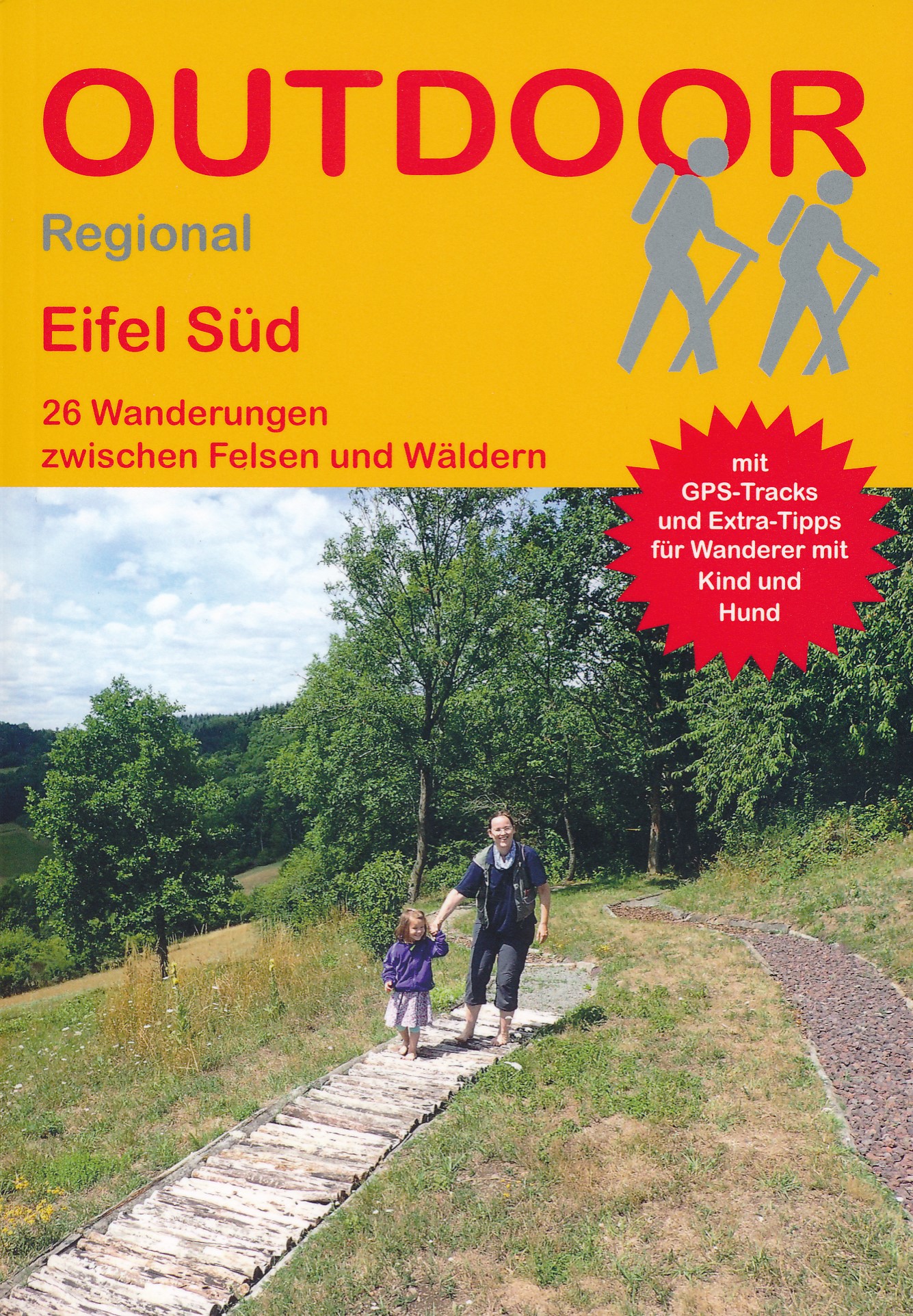
<p> Handzaam boekje met de routebeschrijving inclusief een heleboel praktische informatie. De beschrijving is uitstekend, maar kaarten zijn beperkt en schetsmatig aanwezig. Duits.</p> <p> Die wunderbar wanderbare Eifel bietet neben abwechslungsreicher Landschaft und vielfältiger Kultur ein gutes Wanderwegenetz für jeden Geschmack. Einige der schönsten Touren im Südteil der Eifel stellt dieses Buch vor: Beschrieben werden 26 Wanderungen mit unterschiedlichen Längen und Schwierigkeitsgraden für alle Jahreszeiten und in allen Teilregionen der rheinland-pfälzischen Eifel sowie über die Landesgrenze hinaus in der belgischen und luxemburgischen Eifel. </p> <p> Zu jeder Tour gibt es Tipps für Wanderer mit Kind und Hund und Informationen zu Anreise, Einkehrmöglichkeiten, Markierungen usw. Karten und Höhenprofile ergänzen die genauen Wegbeschreibungen, GPS-Tracks zu jeder Tour können kostenlos heruntergeladen werden.</p>
€15,50
Bekijk product
<p> Fraai uitgevoerd wandelboek met harde kaft, vooral te gebruiken als inspiratieboek. Het is eigenljk te groot om mee te nemen.</p> <p> Wandern, so weit die Füße tragen. Zumindest viele Hundert Kilometer und mehrere Tage am Stück. Das haben alle Fernwanderwege gemein. Ansonsten können sie sehr unterschiedlich sein. Von Einsamkeit geprägt ist beispielsweise der Reykjavegur auf Island, wohingegen man auf dem Spanischen Jakobsweg eher selten alleine läuft. Michael Vogeley stellt 25 Weitwanderwege vor mit allen ihren Besonderheiten. Dazu gibt es die Fernwanderwege E1 bis E11 im Überblick.</p>
€37,50
Bekijk product