
Beantwoord enkele vragen, en binnen seconden geeft AI je een persoonlijk aankoopadvies op maat.
Beantwoord enkele vragen, en binnen seconden geeft AI je een persoonlijk aankoopadvies op maat.

<p> <span style="font-family: "Helvetica Neue", Helvetica, sans-serif, Arial;">Franstalige wandelgids met 100 dagwandelingen verspreid over een groot gebied in de Pyreneeën en ten noorden daarvan. Goede kaarten en duidelijke informatie over de wandelingen.</span></p> <div> Le territoire concerné </div> <div> • Département de l’Ariège</div> <div> • Département de l’Aveyron</div> <div> • Département de la Haute-Garonne</div> <div> • Département du Gers</div> <div> • Département du Lot</div> <div> • Département des Hautes-Pyrénées</div> <div> • Département du Tarn</div> <div> • Département du Tarn-et-Garonne</div> <div> Le guide</div> <div> • 100 itinéraires de 1h45 et 7h00</div> <div> • Cartographie sur fond IGN au 1 : 25 000 pour se repérer facilement</div> <div> • Détail des centres d’intérêts</div> <p> </p> <div> • Renseignements pratiques et adresses utiles.</div>
€21,50
Bekijk product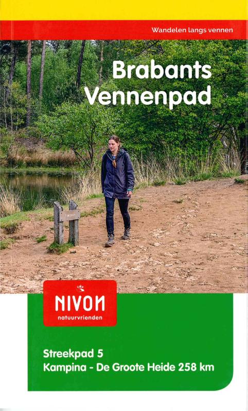
<p> Brabant Vennenpad Noord-Brabant, de provincie van het rijke roomse leven met Brabants bont, bierbrouwerijen en worstenbroodjes… Het Brabants Vennenpad brengt u in het zuidoostelijk deel van de provincie, langs vennen in de Kampina, De Kempen en De Groote Heide, door het Land van Van Gogh en over landgoederen. Prachtige paadjes langs de meanderende Dommel brengen u steeds zuidelijker tot de Belgische grens.</p>
€16,90
Bekijk product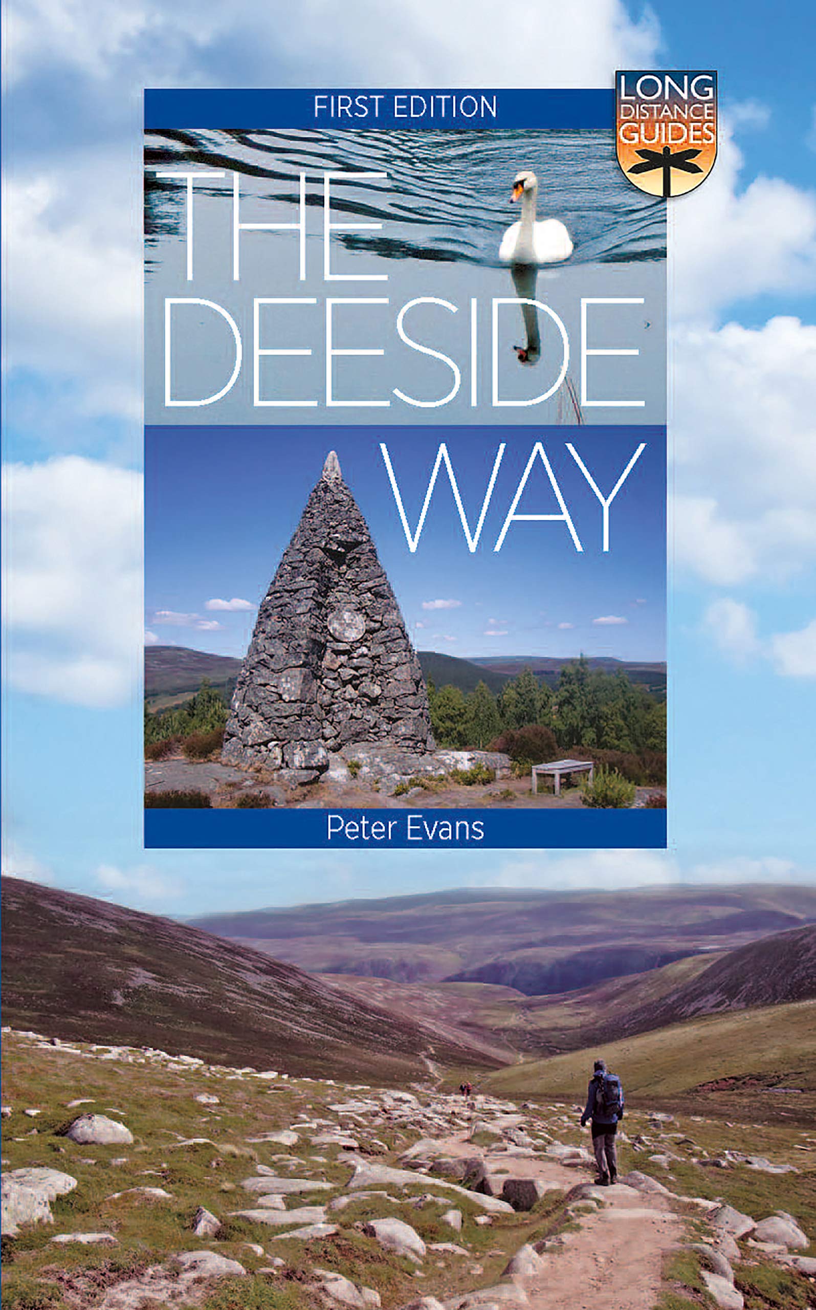
<p> The Deeside Way is a long-distance path running for 66km (41 miles) from Aberdeen, the oil capital of Europe, to Ballater in Royal Deeside in the Cairngorms National Park. Mainly following the course of old Royal Deeside Railway line, it is suitable for cyclists as well as walkers. There is much to be seen along the Way of scenic beauty, historical interest and thriving wildlife. There are fascinating links to the Romans, to Queen Victoria and Balmoral and even to bodysnatchers! This new Guide covers all of these, with a wealth of practical information on preparation for the walk, accommodation, transport and much else. As well as describing the Way itself, Peter Evans includes six additional walks in and around Deeside, varying from short low-level walks to mountain summits.</p>
€23,95
Bekijk product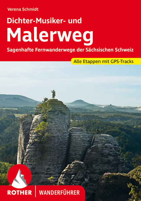
<div> Uitstekende wandelgids met een groot aantal dagtochten in dal en hooggebergte. Met praktische informatie en beperkt kaartmateriaal! Wandelingen in verschillende zwaarte weergegeven in rood/blauw/zwart.</div> <div> </div> <div> detaillierte Wanderkarten</div> <div> aussagekräftige Höhenprofile</div> <div> GPS-Tracks zum Download</div> <div> </div> <div> Kein anderes Felsengebirge entfachte die Sehnsüchte der Menschen so sehr wie die wildromantische Sächsische Schweiz und prägte so eine ganze Epoche der Kunst- und Literaturgeschichte Europas. Inspiriert von diesem Zusammenspiel aus exponierten Felsen, verwunschenen Schluchten und dem mäandernden Elbtal schufen Maler, Komponisten und Dichter ihre Meisterwerke. Der Zauber des Elbsandsteingebirges ist bis heute ungebrochen. Dieser Rother Wanderführer stellt die schönsten Fernwanderwege Sachsens vor: den »Malerweg« und den »Dichter-Musiker-Malerweg«</div> <div> </div> <div> Der »Malerweg« zählt zu den schönsten Rundwanderwegen Deutschlands. Kein Wunder: Auf dem »König der Wanderwege« durch die Sächsische Schweiz folgt ein Highlight nach dem anderen. Entlang aussichtsreicher Panoramawege besteigt man exzentrische Tafelberge und steinerne Burgen. In verwegenen Schluchten entdeckt man zarte Wasserfälle und sandige Höhlen. Und mitten hindurch fließt die majestätische Elbe - so, als ob die Zeit stehen geblieben sei.</div> <div> </div> <div> Den Spuren des historischen Malerwegs folgt der »Dichter-Musiker-Malerweg«. Vom historischen »Blauen Wunder« in Dresden bis zum imposanten Prebischtor der Böhmischen Schweiz wandert man hoch über dem Elbtal, an idyllischen Städtchen vorbei, über die luftige Basteibrücke und mitten durch das Herz des sagenhaften Landstriches.</div> <div> </div> <div> Jede Etappe von Malerweg und Dichter-Musiker-Malerweg verfügt über eine zuverlässige Wegbeschreibung und alle Infos zu Anforderungen, Varianten, Einkehr- und Übernachtungsmöglichkeiten. Ergänzt werden sie durch eine Wanderkarte mit Routenverlauf sowie ein aussagekräftiges Höhenprofil. GPS-Daten stehen zum Download zur Verfügung. Der Wanderführer liefert auch Infos zur Historie und zu Sehenswürdigkeiten. Wochenendwanderer können sich aus beiden Weitwanderwegen die vortrefflichsten Abschnitte herauspicken.</div>
€17,50
Bekijk product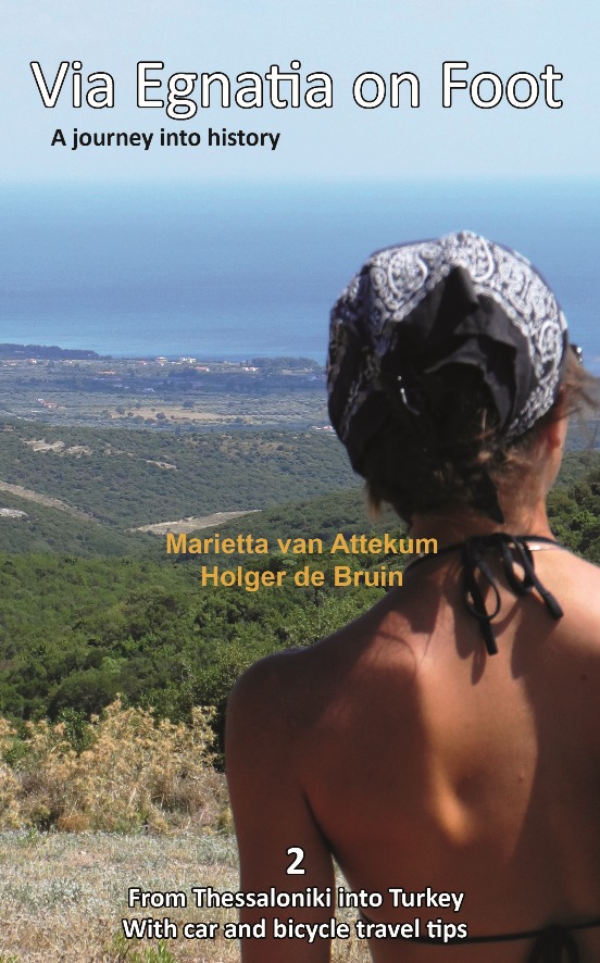
<div> Via Egnatia on foot, Part 2, covers a distance of more than 550 kilometers. The book starts just as our first book with practical tips for travellers (chapter 1) and a description of the history of the Via Egnatia (chapter 2). In chapter 3 all relevant aspects of the trail are described in a general way. For instance conditions of the road, description of the landscape and the practical use of the maps. In chapter 4 you will find detailed information on the original Via Egnatia stages of the trail; long distances are cut up into separate walking sections. Each stage/section provides a description and a map of the track, interesting historical and cultural facts and monuments, illustrated with beautiful pictures. At the end we present the traveller two options to enter Turkey: one leads you to Edirne, the other one crosses the border to Ipsala.</div> <div> </div> <div> In general this trail is not difficult for walkers, although after heavy rain it may be less easy and circumstances may differ considerably, so some improvisation can be requested. Although our description aims at walkers, in chapter 5 we include special information for people who want to discover the Via Egnatia by bike or by car. In chapter 6 we give information on the historical and actual background of the region.</div> <div> </div> <div> Both Via Egnatia books are meant for the traveller who is interested in the history and culture of the Balkans. The landscape is beautiful, there are many remnants of the interesting past, people are hospitable as ever, so you can expect a wonderful experience. If you want to know more about the people along the road and their history, you can find suggestions for further reading in appendix B. In appendix A we have included a list with useful words and expressions in Greek and in Turkish, so you will be able to communicate at a basic level with the people you meet on the way.</div>
€22,95
Bekijk product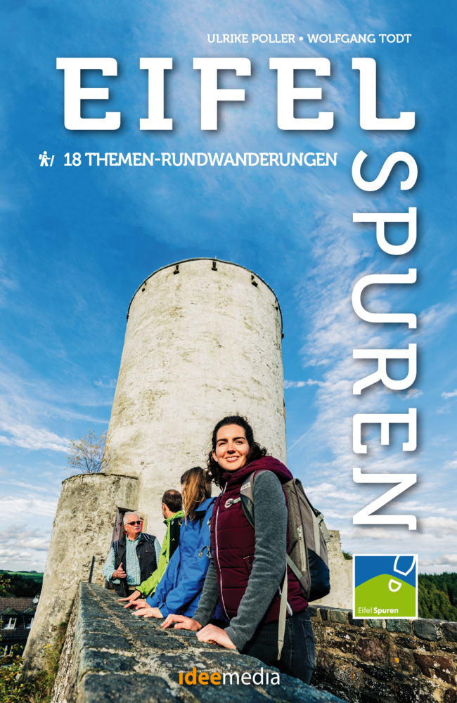
<div> Stille Wege, lauschige Täler, kulturelle Höhepunkte: 18 Eifelspuren machen Lust, die reizvolle Naturlandschaft vor den Toren von Aachen und Köln zu Fuß neu zu entdecken. Von leicht bis sportlich, von 3 bis 21 Kilometern ist für jeden Geschmack ein Themenweg für einen perfekten Wandertag dabei. Die meisten Wege sind den öffentlichen Nahverkehr angeschlossen. Für die Anfahrt mit dem Auto zu den teils versteckt liegenden Parkplätzen enthält das Buch ausführliche Wegbeschreibungen, QR-Codes machen in Verbindung mit Smartphones die Navigation besonders einfach, ausführliche Wegbeschreibungen die Touren nahezu unverlaufbar.</div> <div> </div> <div> Auf 18 neuen Themen-Rundwanderwegen werden Eifelträume wahr: Die Eifelspuren bieten mit Touren zwischen 3 und 21 Kilometern Wanderspaß für jeden Geschmack. Ausführliche wie übersichtliche Anfahrts- und Wegbeschreibungen, GPS-Daten, eine Direktanbindung an die App "traumtouren" und viele Fotos machen bereits die Auswahl und Vorbereitung jeder Tour besonders einfach.</div>
€16,95
Bekijk product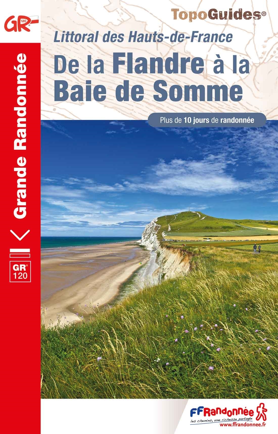
<p> Franstalige wandelgids met een beschrijving van een aantal dagtochten / rondwandelingen. Uitstekende beschrijvingen met duidelijk kaartmateriaal. Mislopen is nauwelijks mogelijk, maar ja .. de franse taal! Ook praktische informatie staat in deze gids. Alle gidsen bevatten een door ons toegevoegde uitgebreide frans - nederlandse wandelwoordenlijst.</p> <p> Plus de 10 jours de randonnée sur le littoral des Hauts-de-France à travers le GR® 120. De la Flandre à la Baie de Somme, découvrez de nombreux sites naturels exceptionnels : baie d'Authie, dunes d'Écault, platier d'Oye...</p> <div> L'itinéraire du GR® 120 commence en Belgique depuis la ville de bord de mer, la Panne.</div> <div> </div> <div> Il se poursuit le long du littoral dans le Pas-de-Calais, dévoilant les trésors de la côte d'Opale : la réserve naturelle du platier d'Oye, la baie de Wissant, la ville portuaire de Boulogne-sur-Mer ou encore les dunes d'Écault.</div> <div> </div> <div> Pour les amoureux de grands espaces naturels encore sauvages, l'itinéraire mène le randonneur à la baie d'Authie où la faune et la flore s'épanouissent.</div> <div> </div> <div> Le GR® 120 se termine à Tréport en Seine-Maritime, station balnéaire animée par son port de pêche.</div>
€19,95
Bekijk product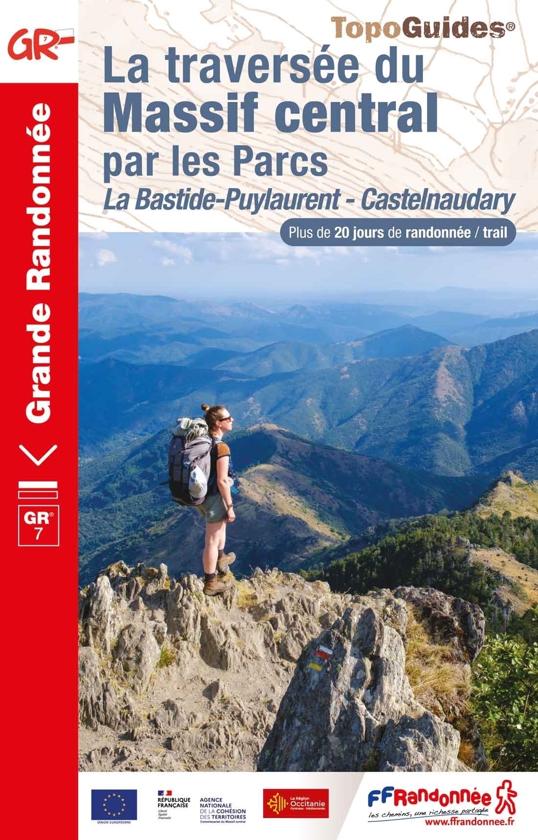
<p> Franstalige wandelgids met een beschrijving van een aantal dagtochten / rondwandelingen. Uitstekende beschrijvingen met duidelijk kaartmateriaal. Mislopen is nauwelijks mogelijk, maar ja .. de franse taal! Ook praktische informatie staat in deze gids. Alle gidsen bevatten een door ons toegevoegde uitgebreide frans - nederlandse wandelwoordenlijst.</p> <p> Traversez les parcs naturels du Massif central. Plus de 20 jours de randonnée sur la partie sud du GR® 7, de La Bastide-Puylaurent à Castelnaudary.</p> <div> Le massif central, vaste étendue montagnarde où le GR® 7 évolue sur près de 800 kilomètres.</div> <div> </div> <div> Ce topoguide présente la partie sud de la traversée de la Bastide-Puylaurent à Castelnaudary. Elle se distingue par des paysages naturels remarquables : les montagnes cévenoles, le canyon du cirque de Navacelles, les forêts de la Montagne noire ou encore les landes à bruyère des monts du Caroux.</div> <div> </div> <div> Il est possible de s’écarter légèrement de l’itinéraire pour accéder au sommet du Mont Lozère culminant à 1 699 mètres.</div> <div> </div> <div> Le GR® 7 convient aussi à la pratique du trail.</div>
€19,95
Bekijk product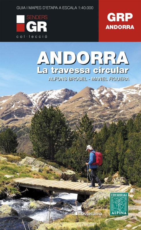
<div> Wandelgids met een wandelkaartenset van deze uitdagende route in Andorra. </div> <div> </div> <div> De route is uitstekend beschreven in een handige gids in ringband. Wel in het Catalaans Spaans! Op de kaarten met schaal 1:40.000 is de route duidelijk ingetekend; je zou wellicht het boek thuis kunnen laten.</div> <div> </div> <div> De lengte en de grootsheid van deze route van de Gran Recorregut del País (GRP)-route is dusdanig dat veel bergwandelaars het erover eens zijn dat als je deze route niet hebt gelopen, je het Prinsdom Andorra niet echt goed kent. Het is een route van in het totaal zo'n 115 km en met een cumulatief hoogteverschil van 8.500 m. Dit allemaal tesamen geeft een cirkel (Travessa Cicrculair) door een land waar de bergen nooit lijken te eindigen. Deze publicatie bestaat uit een gids (Catalaans) en 4 kaarten op schaal 1:40.000 met de technische moeilijkheden en de profielen van de 7 etappes van de traverse.</div>
€25,95
Bekijk product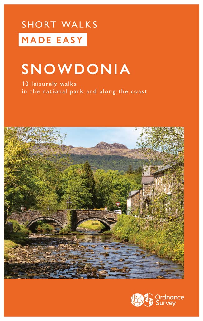
<div> Everybody can explore Snowdonia, from England and Wales’ highest mountain to magical medieval castles and the spectacular Conwy coastline, with these accessible, family-friendly walks. Get outside and active with the whole family amidst the mysterious legends and natural beauty of Snowdonia.</div> <div> </div> <div> Snowdonia Short Walks Made Easy include:</div> <div> </div> <div> - Take Victorian tramcars or the chairlift to the summit of the Great Orme, then wander wildflower-rich meadows for incredible views of the mountains, the sea and the Isle of Anglesey</div> <div> - Follow the Lôn Gwyrfai trail round beautiful Llyn y Gader through Beddgelert Forest to the lovely village, with views of Snowdon and Y Garn throughout</div> <div> - Get off the beaten track in the valley of Cwm Penamnen with views of the cliffs of Moel Sabod and the 13th-century Dolwyddelan castle</div> <div> - Discover Porthmadog on a fascinating walk over Borth-y-Gest headland, the ingenious Cob and the salt marshes home to many seabirds</div> <div> - Explore Dolgellau and the riverside walk to Penmaenpool along the Mawddach Trail</div> <div> - Stroll through idyllic lakeside woods at Llyn Mair, listening out for the steam trains and glimpsing beautiful views of the Vale of Ffestiniog</div> <div> </div> <div> OS Pathfinder Guides: Short Walks Made Easy:</div> <div> </div> <div> - 10 accessible walks suitable for the whole family</div> <div> - All routes are between 2 to 5 miles and can be completed all year round</div> <div> - Know what to expect before you go: Information on locations of cafes/pubs and toilets, terrain, hilliness and accessibility for pushchairs and wheelchairs</div> <div> - Large-scale Ordnance Survey maps for ultra-easy navigation and route-finding, featuring intuitive pictorial symbols</div> <div> - Numbered points which tie maps to route descriptions and walk profiles</div> <div> - Route photographs for each numbered point so you know exactly where you’re going</div> <div> - Discover GPS waypoints, parking information and detailed route descriptions for foolproof navigation</div> <div> - Enhance your adventure with stories behind each walk and nature notes</div> <div> - Get active outside and enjoy the physical and mental health benefits</div>
€10,95
Bekijk product