
Beantwoord enkele vragen, en binnen seconden geeft AI je een persoonlijk aankoopadvies op maat.
Beantwoord enkele vragen, en binnen seconden geeft AI je een persoonlijk aankoopadvies op maat.
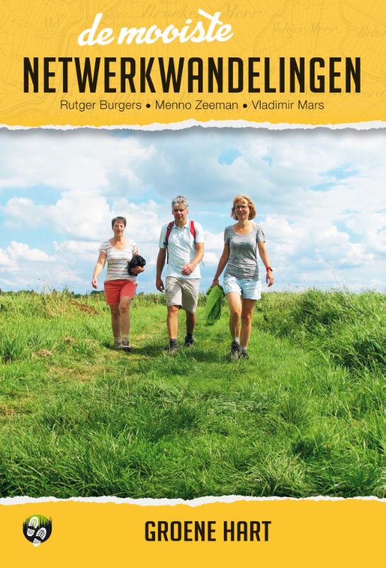
<p> De reeks ‘De mooiste netwerkwandelingen' heeft zijn succes te danken aan een heldere formule waarmee iedereen een mooie wandeling in Nederland kan maken. Zowel voor de ervaren wandelaar als voor de wandelaar met wat minder meters in de benen bieden deze gidsen een prachtige ervaring in de natuur. Op basis van eigen ervaringen hebben de auteurs de leukste wandelrondjes en lijnwandelingen geselecteerd. Het resultaat is gebundeld in gidsjes per regio met 15 wandelpareltjes van tussen de 5 en 15 km, waarvan minstens 50% uit half- of onverharde paden bestaat. De routes zijn zo beschreven, in kaart en beeld gebracht dat de lezer er zin in krijgt, dat hij ook te voet de polder in wil.</p> <p> De kernwaardes van deze reeks:</p> <p> • 15 wandelingen van 5 tot 16 km, zoveel mogelijk onverhard</p> <p> • Uitsluitend routes uit gemarkeerde wandelnetwerken</p> <p> • Topografische routekaartjes</p> <p> • Landschapsfoto’s & historische illustraties</p> <p> • Downloadbare GPS-tracks</p>
€16,99
Bekijk product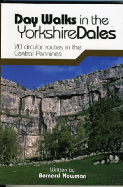
<div> Day Walks in the Yorkshire Dales is the fourth title in Vertebrate Publishing's series of compact and portable hillwalking guidebooks. This book showcases 20 circular walks in the Yorkshire Dales National Park, between 6 and 11 miles (10 and 17 kilometres) in length, suitable for hillwalkers of all abilities. The routes are split into three geographical areas - south, east, and north - and include walks to the Dales' most regarded beauty spots, such as Malham Cove, Gordale Scar, Brimham Rocks and Hardraw Force, as well as the trio of sought-after peaks Pen-y-ghent, Ingleborough and Whernside.</div> <div> </div> <div> The author of this guidebook, Bernard Newman, is a freelance outdoor writer and photographer, and former editor of the internationally acclaimed Mountain magazine. A Yorkshire Dales local and graduate geologist, in his route descriptions he explores the incredible geology that has created the breathtaking scenery on show in the Dales. Each route in this guide is described with easy-to-follow directions and details of distance, navigation information, refreshment stops and is plotted on clear and easy to use Ordnance Survey 1:25,000 mapping.</div> <div> </div> <div> Reprinted in 2019 with updated mapping and revisions.</div>
€20,95
Bekijk product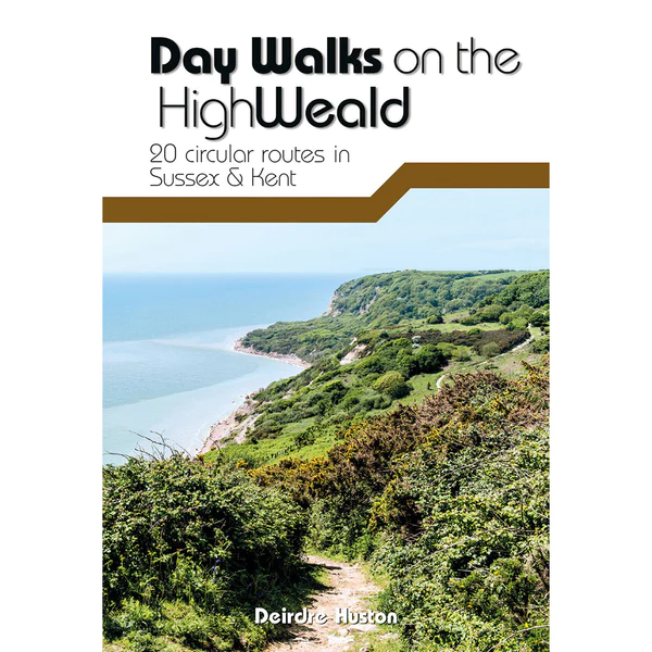
<div> Day Walks on the High Weald features 20 circular routes between 6.5 and 13.9 miles (10.5km and 22.4km) in length, spread across this Area of Outstanding Natural Beauty in the south-east of England. Local author Deirdre Huston has compiled her favourite walks in the region, which showcase the High Weald's rich history and varied landscape. Walk down old coach roads.</div> <div> </div> <div> Clamber through deserted woodland and along riverbanks. March past castles and skirt battlefields. Linger in meadows and leap across Wealden streams.</div> <div> </div> <div> See the countryside that inspired A.A. Milne and Rudyard Kipling. Visit Hastings Country Park, stroll around Bewl Water and through tranquil St Leonard's Forest.</div> <div> </div> <div> Marvel at the Ouse Valley Viaduct and Bodiam castle, and consider the epic history of Battle and its surrounding landscape. Together with stunning photography, each route features Ordnance Survey 1:25,000 maps, easy-to-follow directions, details of distance and navigation information, and refreshment stops and local information.</div>
€20,95
Bekijk product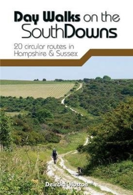
<div> Day Walks on the South Downs features 20 circular routes, between 6 and 14 miles (9km and 22km) in length, suitable for hill walkers of all abilities. The routes are split into three geographical areas - Hampshire, West Sussex and East Sussex - and include walks to the most historic and beautiful areas of the South Downs National Park, including Winchester Hill Fort, Black Down, Chanctonbury Ring, Devil's Dyke, Ditchling Beacon and Beachy Head. This guidebook is written by Deirdre Huston, a South Downs local, keen hill walker and experienced author.</div> <div> </div> <div> Each route in this guide is described with easy-to-follow directions and details of distance, navigation information, refreshment stops and is plotted on clear and easy to use Ordnance Survey 1:25,000 mapping. Also included is a detailed Appendix.</div>
€20,95
Bekijk product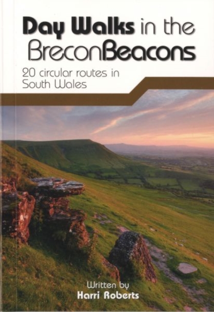
<div> Day Walks in the Brecon Beacons features 20 circular routes between 6.8 and 16.5 miles (11km and 16.6km) in length, suitable for hill walkers of all abilities. Local author and walker Harri Roberts shares his favourite walks in the region, including circuits in the hills around Llangors Lake, the Taf Fechan Skyline and Pen y Fan, and the Llanbedr Horseshoe. The routes are split into four areas - Blorenge and The Black Mountains, The Brecon Beacons, Mynydd Llangatwg and Mynydd Llangynidr, Fforest Fawr and The Black Mountain.</div> <div> </div> <div> Each route features Ordnance Survey 1:25,000 maps, easy-to-follow directions, details of distance and navigation information, and refreshment stops and local information. The walks are illustrated with stunning photography by the author and outdoor photographer Adam Long.</div>
€20,95
Bekijk product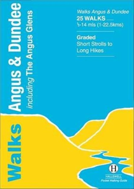
<p> This guide covers the old county of Angus: from the cliffs and beaches of the coast, through the wide farmland of Strathmore to the fine hill paths of the Angus Glens. Walks range from 0.5 miles to 14 miles (1-22.5km). Routes include: Glen Clova to Glen Muick, Glen Esk to Glen Tanar, Montrose Basin and Arbroath Cliffs.</p>
€5,95
Bekijk product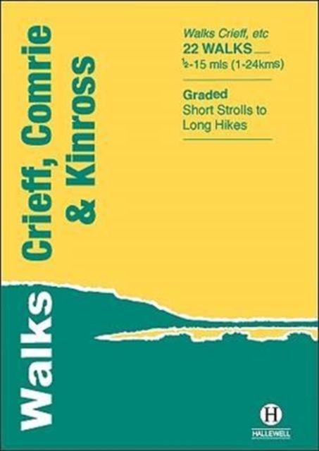
<div> Walks Crieff, Comrie & Kinross includes walks in the south Perthshire hills, around Loch Earn and Loch Tay, and the Ochils, as well as the path network around Crieff. The 22 walks featured range from 0.5 miles to 15 miles (1-24km). Routes include: The Knock (Crieff), Ben Vorlich, Comrie to Callander and a fine circuit of Loch Leven. Previously published as Walks South Perthshire, the book has been rewalked and updated in 2016 to reflect changes on the ground. Part of a popular series of A6 pocket walking guides which describe routes which are suitable for walkers of all abilities and to suit all tastes. Route descriptions are accompanied by 2-colour sketch maps. The guides are illustrated with line illustrations, and will provide walkers with a good introduction to what each area covered has to offer.</div> <div> </div>
€5,95
Bekijk product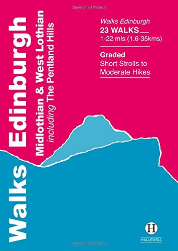
<div> Rewalked and updated in 2021, Walks Edinburgh, Midlothian & West Lothian including The Pentland Hills features walks in and around Scotland's capital city. The guide covers the city of Edinburgh, the farmland and coast to the west, and the northern part of the Pentland Hills - the latter providing an extensive network of fine hill walks within easy reach of the city. The 23 walks featured range from 1 mile to 22 miles (1.5-35km). Routes include: Holyrood Park & Arthur's Seat, South Queensferry to River Almond, Roslin and thirteen walks in the Pentland Hills. The guide is part of a popular series of A6 pocket walking guides which describe routes which are suitable for walkers of all abilities and to suit all tastes. Route descriptions are accompanied by 2-colour sketch maps. The guides are illustrated with line illustrations, and will provide walkers with a good introduction to what each area covered has to offer.</div> <div> </div>
€5,95
Bekijk product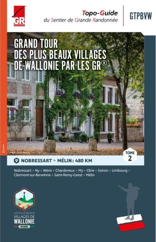
<div> Wandelgids in 3 delen langs de mooiste dorpen van Wallonië</div> <div> </div> <div> Deze route is grotendeel gebaseerd op het bestaande GR- en GRP-netwerk en vormt een 1.500 kilometer lange route die deze 32 karaktervolle dorpen met elkaar verbindt. De gidsen bevatten routes, beschrijvingen en gedetailleerde kaarten. Een specifieke GTPBVW-markering werd geplaatst om de route te markeren. Deze staat verder uit elkaar dan de traditionele GR streepjesmarkeringen.</div> <div> </div> <div> Je wandelt door prachtige landschappen en regio's die soms weinig bekend zijn, maar die je elke keer betoverende plekken laten ontdekken, gelegen in een rijke natuurlijke omgeving en in goed bewaarde oorden waar het onroerend erfgoed de geschiedenis van onze voorouders laat weerklinken.</div> <div> </div> <div> Deel 1: Namur - Nobressart (520 km)</div> <div> Deel 2: Nobressart - Mélin (480 km)</div> <div> Deel 3: Mélin - Namur (525 km)</div> <div> </div> <div> <div> Le topo-guide à thème (GRT), "LES BEAUX VILLAGES DE WALLONIE PAR LES GR GTPBVW®" rédigé en trois tomes, vous invite à parcourir la Wallonie et ses régions si particulières avec pour objectif la découverte des 33 villages labellisés « Plus Beaux Villages de Wallonie » qui font la fierté de leurs habitants et des Wallons amoureux du patrimoine. Cet itinéraire s’appuie sur le réseau GR et déroule un tapis rouge long de 1500 kilomètres reliant 33 villages de caractère. De manière plus espacée, une balise spécifique GTPBVW jalonne le parcours.</div> <div> </div> <div> Vous sillonnerez des paysages magnifiques et des contrées parfois mal connues mais qui, à chaque fois, vous feront découvrir des endroits enchanteurs, logés dans un environnement naturel riche, des endroits préservés où le patrimoine bâti fait résonner l’histoire de nos ancêtres.</div> <div> </div> <div> Les Plus Beaux Villages de Wallonie par les Sentiers GR sont à vos pieds… À vous d’en profiter !</div> <div> </div> <div> La plupart des chemins empruntés sont basés sur le réseau des GR et GRP existant. Parcours, descriptifs et cartographies détaillées sont à votre disposition dans ce guide rédigé en trois tomes. Vous accommoderez vos parcours selon vos envies, par tronçons, en organisant de courts séjours ou en ciblant une région. À vous de choisir ! L’essentiel est d’inciter chacun à voyager au plus près de chez soi : là où la nature et les richesses se trouvent, au coin d’un sentier ou d’une ruelle … l’aventure commence et est accessible à tous.</div> <div> </div> <div> Le Tome 1 démarre à Namur et vous mènera dans 13 villages jusqu’au Beau Village de Nobressart en province de Luxembourg. Vous sillonnerez le Condroz, la Fagne-Famenne, l’Ardenne et la Lorraine.</div> <div> </div> <div> Le Tome 2 vous mènera dans 10 villages de Nobressart à celui de Mélin en Brabant wallon. Vous sillonnerez la Lorraine, le Condroz, la Fagne-Famenne, le pays de Herve et la Hesbaye.</div> <div> </div> <div> Le Tome 3 vous enverra dans 10 autres villages sillonner la Hesbaye, les Plateaux limoneux brabançon et hennuyer, la Fagne-Famenne et le Condroz.</div> <div> </div> <div> <div> Étape 14 : Nobressart – Ny</div> <div> Étape 15 : Ny – Wéris </div> <div> Étape 16 : Wéris – Chardeneux </div> <div> Étape 17 : Chardeneux – My</div> <div> Étape 18 : My – Olne </div> <div> Étape 19 : Olne – Soiron </div> <div> Étape 20 : Soiron – Limbourg</div> <div> Étape 21 : Limbourg – Clermont-sur-Berwinne </div> <div> Étape 22 : Clermont-sur-Berwinne – Saint-Remy-Geest</div> <div> Étape 23 : Saint-Remy-Geest – Mélin</div> </div> </div> <p> </p>
€25,95
Bekijk product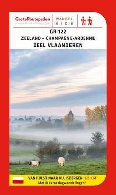
<div> De internationale GR 122 start in het Nederlandse Hulst en eindigt 500 km verder in het Franse Son, waar de route aansluit op de GR 12.</div> <div> </div> <div> In het Vlaamse deel van de GR 122 wandel je vanaf Hulst eerst door de vlakke polders. Langs de begonia- en azaleavelden van Lochristi bereik je de heksengemeente Laarne. In het Land van Rode wandel je op charmante wegels door waterrijke natuur en vruchtbare landbouwgebieden, het verleden en de toekomst gaan er hand in hand. Voorbij de Zwalmstreek verlaat je de Scheldevallei en komen de heuvels en bossen van de Vlaamse Ardennen in zicht. Je doet nog het gezellige Ronse aan, om in het Kluisbos het einde van de GR 122 in Vlaanderen te bereiken. Aan de taalgrens sluit de route aan op de GRP 123 Tour de la Wallonie picarde. In Bons-Secours steekt de GR 122 de landsgrens over en eindigt tenslotte in Son aan de GR 12 Amsterdam-Parijs.</div> <div> </div> <div> Acht extra luswandelingen in het laatste deel van deze gids laten je kennis maken met deze typische landschappen.</div>
€22,95
Bekijk product