
Beantwoord enkele vragen, en binnen seconden geeft AI je een persoonlijk aankoopadvies op maat.
Beantwoord enkele vragen, en binnen seconden geeft AI je een persoonlijk aankoopadvies op maat.
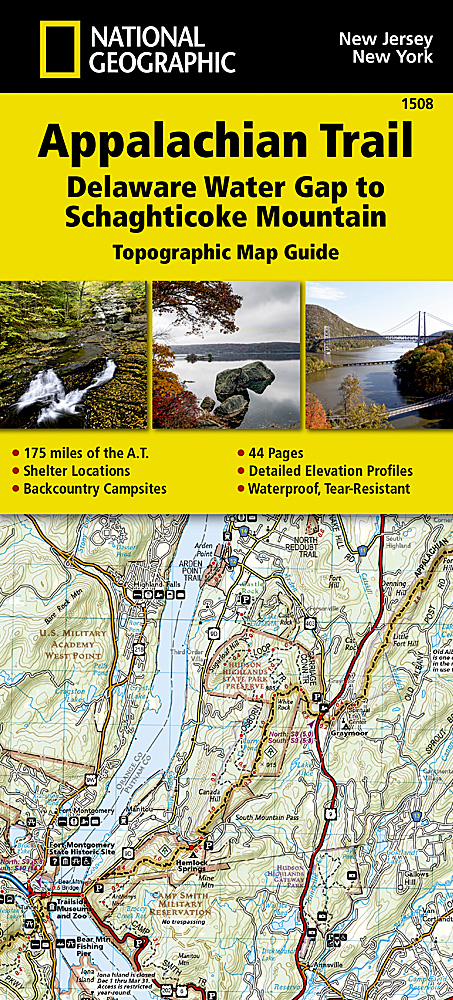
<p> Wandelgids/wandelatlas met weinig tekst, maar goede kaarten van een gedeelte van de Appalachian Trail. </p> <p> Each A.T. Topographic Map Guide includes detailed topographic maps at a detail of 1 inch = 1 mile. Each page is centered on the A.T. and overlaps with the adjacent pages so there is little chance of getting lost. Along the bottom of each page is a trail profile that shows the distance between shelters, camping areas, and trail access points. The map and trail profile provide a step by step visual guide to hiking the trail, mile by rugged mile. The Topographic Map Guide is built for all levels of hiking enthusiasts, from the day tripper to the multi month 'thru-hiker'. The front pages of the printed Topographic Map Guide include resupply information, town inset maps, camping options, and much more.</p> <div> The Delaware Water Gap to Schaghticoke Mountain Topographic Map Guide makes a perfect traveling companion when traversing the New Jersey and New York sections of the Appalachian Trail (A.T.). The trail through New Jersey and New York is surprisingly rugged, and much more remote than one would imagine given its proximity to large population centers. For 160 miles the trail follows long mountain ridges; travels across bogs, wetlands, and broad river valleys; and meanders through numerous state parks, forests, and national park land.</div> <div> </div> <div> Scale 1/63 360 (1 cm = 633 m). 1 inch = 1 mile.</div> <div> </div> <div> This topographic Map Guide is printed on a waterproof, tear-resistant paper. A full UTM grid is printed on the map to aid with GPS navigation.</div>
€16,95
Bekijk product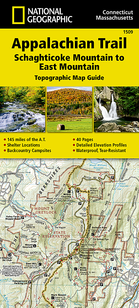
<p> Wandelgids/wandelatlas met weinig tekst, maar goede kaarten van een gedeelte van de Appalachian Trail</p> <p> Each A.T. Topographic Map Guide includes detailed topographic maps at a detail of 1 inch = 1 mile. Each page is centered on the A.T. and overlaps with the adjacent pages so there is little chance of getting lost. Along the bottom of each page is a trail profile that shows the distance between shelters, camping areas, and trail access points. The map and trail profile provide a step by step visual guide to hiking the trail, mile by rugged mile. The Topographic Map Guide is built for all levels of hiking enthusiasts, from the day tripper to the multi month 'thru-hiker'. The front pages of the printed Topographic Map Guide include resupply information, town inset maps, camping options, and much more.</p> <div> The Schaghticoke Mountain to East Mountain Topographic Map Guide makes a perfect traveling companion when traversing the Connecticut and Massachusetts sections of the Appalachian Trail (A.T.). The trail in this section of New England skirts the northwest corner of Connecticut and traverses what remains of a once mighty mountain range. The hiking is moderate through Connecticut and the climbs are short, but can be steep. As the trail crosses into Massachusetts, it enters the Berkshires, characteristic of wooded hills, outstanding views with pleasant, flat hiking along the Berkshire plateau.</div> <div> </div> <div> Scale 1/63 360 (1 cm = 633 m). 1 inch = 1 mile.</div> <div> </div> <div> This topographic Map Guide is printed on a waterproof, tear-resistant paper. A full UTM grid is printed on the map to aid with GPS navigation.</div>
€16,95
Bekijk product
<p> Handzaam boekje met de routebeschrijving inclusief een heleboel praktische informatie. De beschrijving is uitstekend, maar kaarten zijn wat beperkt. Duits.</p> <p> Die 330 km lange Wanderung auf dem E1 von Kautokeino zum Nordkap ist ein unvergessliches Wanderabenteuer. In 15 Etappen laufen Sie durch die Wildnis Nordnorwegens und überqueren die Finnmarksvidda, ein arktisches Plateau, welches durch die Samen, ihre Rentierzucht und die unerschlossene Natur geprägt ist. Der Wanderführer bietet Ihnen eine detaillierte Beschreibung für alle regulären Etappen sowie Alternativrouten und hilft bei der Organisation der Tour. Übersichtskarten und Höhenprofile für jede Etappe, Infos zur Verkehrsanbindung, zu Unterkünften und Verpflegungsmöglichkeiten sowie zahlreiche Tipps erleichtern die Planung und Durchführung dieses Wanderabenteuers.</p> <p> <a href="https://www.dezwerver.nl/media/medialibrary/2019/05/E1-GPS-Tracks.zip">Download GPS Tracks</a></p>
€13,50
Bekijk product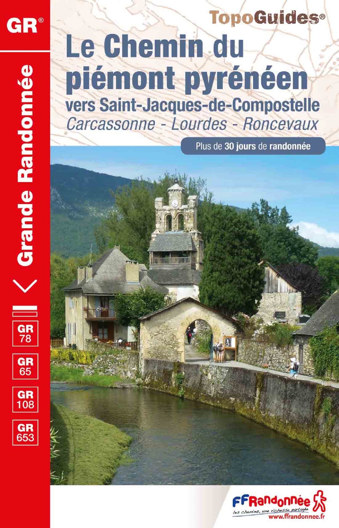
<p> Uitstekende routegids met gedetailleerde kaarten en een routebeschrijving. Fout lopen wordt op deze manier wel erg moeilijk. Met symbolen is weergegeven welke voorzieningen (openbaar vervoer / winkels / overnachtingen) er zijn langs of bij de route. De gids bevat een lijst met overnachtingsadressen inclusief telefoonnummers. Alle gidsen bevatten een door ons toegevoegde uitgebreide frans - nederlandse wandelwoordenlijst.</p> <p> Carcassonne, Pamiers, Lourdes, Pau, Toulouse</p> <p> Encore peu connue, moins fréquentée que la voie du Puy et largement calquée sur d'anciennes voies romaines, la voie du piémont pyrénéen constitue une très belle alternative permettant de découvrir le riche patrimoine des Pyrénées en traversant de magnifiques paysages montagnards.</p> <div> L’itinéraire, le plus sudiste des chemins de Saint-Jacques, relie la Méditerranée à l'Atlantique en parcourant d'Est en Ouest, le Razès, l'Ariégeois, le Comminges, la Bigorre, le pays des Gaves.</div> <div> </div> <div> Des axes nord-sud permettent d'accéder aux cols de franchissement des Pyrénées par les vallées d'Aure, d'Ossau, d'Aspe (col du Somport vers l'Aragon) et à Saint-Jean-Pied-de-Port (col de Roncevaux vers la Navarre).</div> <div> </div> <div> C'est un chemin d'aventure peu connu et riche en patrimoine que l'on peut rejoindre en quittant la Voie d'Arles à Montpellier en direction de Narbonne par Saint-Thibéry et Béziers (Via Domitia).</div>
€17,50
Bekijk product
<p> A guide to walks on the Isle of Skye and the small neighbouring island of Raasay. This guide includes hill climbs and coastal paths on the islands. Walks range from three quarters of a mile to 10 miles (1.2-16 kilomoteres). Routes include: Quiraing, The Fairy Pools, Sligachan to Glen Brittle and the climb up Dun Caan.</p>
€5,95
Bekijk product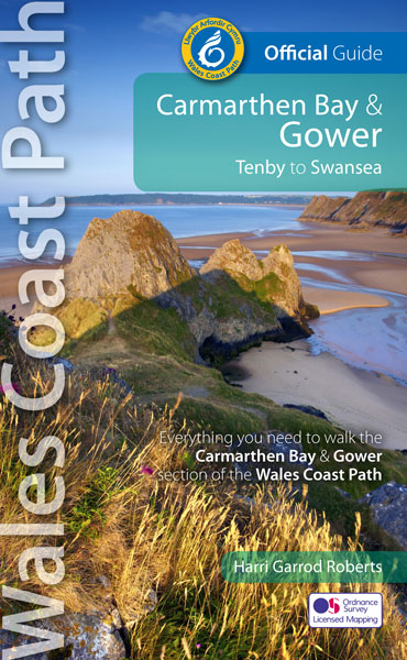
<div> Official Guide: Wales Coast Path: Carmarthen Bay & Gower</div> <div> </div> <div> One of seven Official Guides to the Wales Coast Path</div> <div> </div> <div> The Carmarthen Bay and Gower section of the Wales Coast Path runs for 120 miles/193 kilometres between the popular seaside town of Tenby, via Amroth on the eastern edge of the Pembrokeshire Coast National Park, to Swansea, on the landward side of the Gower Peninsula.</div> <div> </div> <div> This Official Guide splits the route into 12 convenient day sections, each of about 10-17 miles / 16-27 kilometres. It contains everything local and long-distance walkers need to enjoy the path and includes:</div> <div> </div> <div> An overview of Carmarthen Bay and Gower with dedicated history and wildlife sections</div> <div> Twelve day-walk sections with detailed route descriptions and full, enhanced Ordnance Survey mapping</div> <div> Distance charts, section overviews, background information and interpretation of places of interest</div> <div> Stunning professional photographs throughout</div> <div> Information on accommodation, public transport, local information, weather, and tidal links.</div> <div> Contents</div> <div> Wales Coast Path: Discover the shape of a nation</div> <div> Wales Coast Path: An 870-mile coastal adventure</div> <div> The Best of Carmarthen Bay & Gower</div> <div> Carmarthen Bay & Gower: Part of the Wales Coast Path</div> <div> Walking the Carmarthen Bay & Gower Coast – map and distance chart</div> <div> Day Sections</div> <ul> <li> A brief history of Carmarthen Bay & Gower</li> <li> Wildlife in Carmarthen Bay & Gower</li> <li> The Carmarthen Bay & Gower Coast Path</li> <li> Day Section 1: Tenby to Pendine</li> <li> Day Section 2: Pendine to St Clears</li> <li> Dylan Thomas’ ‘New Walk’</li> <li> Medieval Laugharne</li> <li> Day Section 3: St Clears to Llansteffan</li> <li> Day Section 4: Llansteffan to Carmarthen</li> <li> Dylan Thomas country</li> <li> Day Section 5: Carmarthen to Kidwelly</li> <li> Ferryside</li> <li> Day Section 6: Kidwelly to Burry Port</li> <li> Sand, silt and shipwrecks</li> <li> Day Section 7: Burry Port to Loughor</li> <li> Monks, tinplate and golf</li> <li> Day Section 8: Loughor to Llanmadoc</li> <li> Day Section 9: Llanmadoc to Rhossili</li> <li> Burry Holms</li> <li> Day Section 10: Rhossili to Oxwich</li> <li> Day Section 11: Oxwich to Caswell Bay</li> <li> Day Section 12: Caswell Bay to Swansea Marina</li> <li> The Mumbles</li> <li> Welsh Coastal Place Names</li> <li> Visitor Information</li> </ul>
€22,50
Bekijk product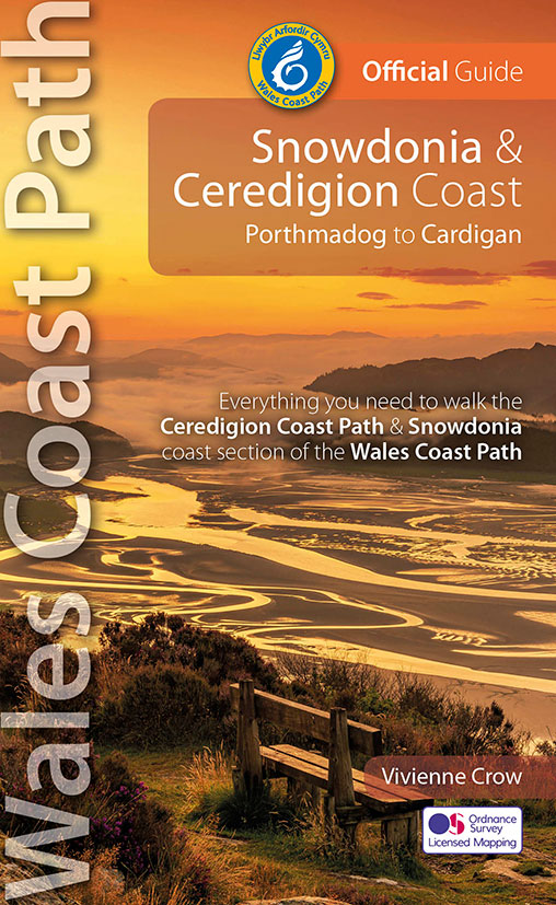
<div> Official Guide: Wales Coast Path: Snowdonia & Ceredigion Coast</div> <div> One of seven Official Guides to the Wales Coast Path</div> <div> This Official Guide to the Snowdonia & Ceredigion Coast section of the Wales Coast Path contains everything local and long-distance walkers need to enjoy the path.</div> <div> </div> <div> Cardigan Bay probably offers a more diverse walking experience than any other section of the Wales Coast Path. The stretch covered in this book – from Porthmadog in the north to Cardigan in the south – largely covers two contrasting Welsh counties.</div> <div> </div> <div> The first 97 kilometres pass through Gwynedd, along the western edge of the Snowdonia National Park. Here, just before the rivers that rise in the highest of the Welsh mountains reach the sea, they fan out to form broad estuaries that provide rich pickings for waders and other birdlife. The estuaries of the Dwyryd, the Mawddach and the Dyfi are the largest of these. Between them are some very large dune systems, including Morfa Harlech and Morfa Dyffryn – home to rare wildlife. Here, walkers are able to stride out along seemingly endless beaches, often with spectacular views inland to the mountains of Snowdonia or across the bay to the peaks of the Llŷn peninsula.</div> <div> </div> <div> Beyond Aberdyfi, at the southwestern tip of the Snowdonia National Park, the coast path heads inland – into the hills – before crossing the Afon Dyfi. After a brief flirtation with the county of Powys, it then passes into Ceredigion, rejoining the coast at Borth. To the north lie the last of the route’s marsh and dune systems while, to the south, the route takes on a completely new character: it is here that the rugged cliffs begin. For the next 91 kilometres, the Wales Coast Path dips in and out of wooded ravines, crosses high cliff-tops where seabirds wheel and dive, and drops in on pretty coastal settlements that will do their best to tempt walkers to linger. Spectacular coastal scenery and a growing sense of solitude are typical of the second half of the route.</div> <div> </div> <div> In total, the 213 kilometres should take about 11 days to walk. And, with no two days the same, it promises to be a varied and fascinating experience.</div> <div> </div> <div> This Official Guide contains everything local and long-distance walkers need to enjoy the path and include</div> <div> </div> <div> An overview of the Snowdonia & Ceredigion Coast with dedicated history and wildlife sections</div> <div> </div> <div> Eleven day-walk sections with detailed route descriptions and full, enhanced Ordnance Survey mapping</div> <div> Distance charts, section overviews, background information and interpretation of places of interest</div> <div> Stunning professional photographs throughout</div> <div> Information on accommodation, public transport, local information, weather, and tidal links.</div> <div> Contents</div> <ul> <li> Wales Coast Path: An 870-mile coastal adventure</li> <li> The Best of the Snowdonia & Ceredigion Coast</li> <li> Snowdonia & Ceredigion Coast: Part of the Wales Coast Path</li> <li> Walking the Snowdonia & Ceredigion Coast — map and distance chart</li> <li> Limited for time? The Snowdonia & Ceredigion Coast in a nutshell</li> <li> A brief history of the Snowdonia & Ceredigion Coast</li> <li> Wildlife along the Snowdonia & Ceredigion Coast</li> <li> Sand dunes, expansive estuaries and rugged cliffsDay Section 1: Porthmadog to Harlech</li> <li> Heritage railways</li> <li> An ‘Iron Ring’ of castles</li> <li> Day Section 2: Harlech to Barmouth</li> <li> Day Section 3: Barmouth to Lwyngwril</li> <li> Day Section 4: Lwyngwril to Aberdyfi</li> <li> Day Section 5: Aberdyfi to Machynlleth</li> <li> Day Section 6: Machynlleth to Borth (or Ynyslas)</li> <li> Day Section 7: Borth (or Ynyslas) to Aberystwyth</li> <li> Bottlenose dolphins</li> <li> Day Section 8: Aberystwyth to Llan-non</li> <li> Day Section 9: Llan-non to New Quay</li> <li> Day Section 10: New Quay to Aberporth</li> <li> Day Section 11: Aberporth to Cardigan</li> <li> Welsh Coastal Place Names</li> <li> Visitor Information</li> </ul>
€23,95
Bekijk product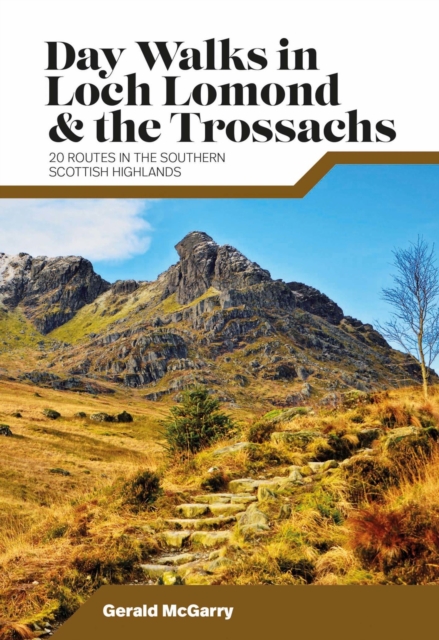
<p> Day Walks in Loch Lomond & the Trossachs features 20 day-length routes suitable for hillwalkers of all abilities. Researched and written by experienced local walker Gerald McGarry, the walks explore the highlights of the Loch Lomond & The Trossachs National Park including the mountains of An Caisteal, Ben Lomond and Ben Ledi. Together with stunning photography, each route features Ordnance Survey 1:25,000 maps, easy-to-follow directions, details of distance and navigation information, and refreshment stops and local information.</p>
€20,95
Bekijk product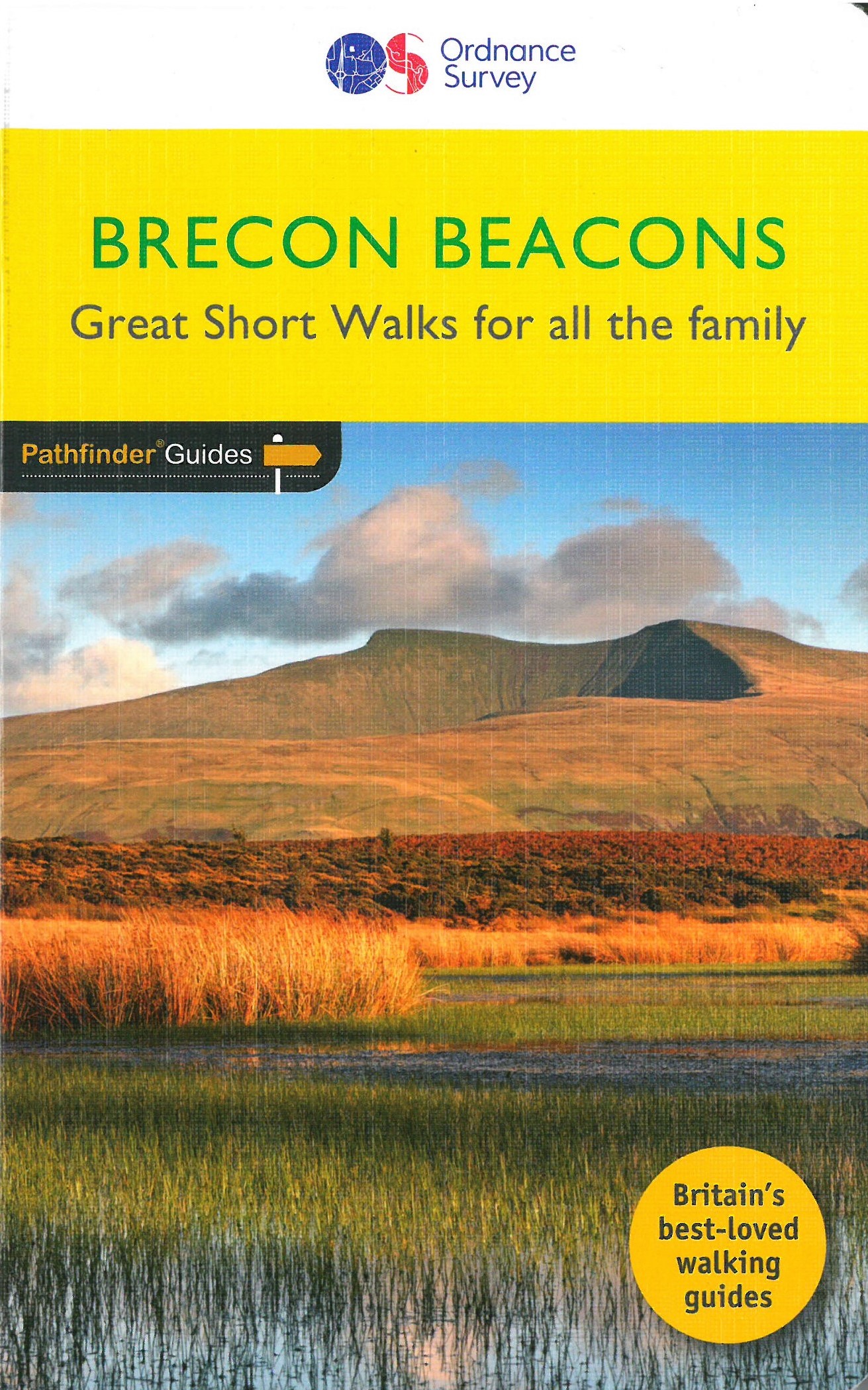
<p> Wandelgids van een deel van Wales. Deze gids bevat 20 wandelingen, geschikt voor de hele familie. De bijbehorende kaarten zijn uitstekend: men heeft de topografische kaarten van Ordnance Survey gebruikt waarop de route is ingetekend. Daarnaast praktische informatie over de wandeling en wat beschrijvingen van het gebied.</p> <div> et outside and get active with all the family in the gorgeous Brecon Beacons with these 20 hand-picked and lovingly illustrated short walks. Everybody can enjoy country walking amidst mountains, lakes and forests and there are even accessible routes up the Sugar Loaf, around the Usk Reservoir and to the top of Pen y Fan.</div> <div> </div> <div> Featured Brecon Beacons Short Walks include:</div> <div> </div> <div> - Cross the Usk Bridge and see castle ruins on the riverside walk at Castle Meadows</div> <div> - Discover a legendary lake at Llyn y Fan Fach</div> <div> - Climb grassy mountain paths to the rocky summit of the iconic Sugar Loaf</div> <div> - Enjoy great views from an Iron Age Fort at Mynnyd Illtud</div> <div> - See the dazzling Ystradfellte waterfalls and visit Porth yr Ogof cave</div> <div> - Tackle Pen y Fan, the highest point in the Beacons, for incredible views from the summit</div> <div> - Take a riverside path through lovely woodland amid canal heritage at Gilwern Wharf and the Clydach Gorge</div> <div> - Spot dippers and see the huge dam at the Grwyne Fawr Reservoir</div> <div> - Wander the woodland paths of the Usk Reservoir</div> <div> </div> <div> Great Short Walks (Pathfinder Guides):</div> <div> </div> <div> - 20 short country walks in one guidebook, ranging from 1½-5½ miles</div> <div> - The definitive pocket book guide to Great Britain’s great outdoors</div> <div> - Ideal for families, with walks selected for accessibility and including information about what to expect along the way (including ascents, stiles and difficult terrain)</div> <div> - Clear, large-scale Ordnance Survey maps: 1:25,000 scale (4cm to 1km or 2½ inches to one mile)</div> <div> - Includes Ordnance Survey map extracts, GPS waypoints, parking information and detailed route descriptions for foolproof navigation</div> <div> - Enhances your walk with information on places of interest en route as well as good pubs and places for refreshment nearby</div>
€11,50
Bekijk product
<div> Get outside in the Cairngorms, Britain’s largest national park, with ten tried-and-tested accessible walks along the Spey Valley. Discover ancient Caledonian woodland, beautiful lochs and sparkling rivers against a backdrop of snow-capped mountains, waiting for the whole family to enjoy.</div> <div> </div> <div> Aviemore and the Cairngorms Short Walks Made Easy include:</div> <div> </div> <div> - Explore Loch Garten and Loch Mallachie, an RSPB Reserve and a haven for ospreys, and pine woodland filled with rare wildlife</div> <div> - Follow the line of the Strathspey Railway and see steam trains chugging past from Aviemore to the ‘osprey village’ of Boat of Garten</div> <div> - Go for a woodland ramble through Glenmore Forest Park to glacial Loch Morlich, where you can stroll the red sands of the highest beach in Britain</div> <div> - Wander the enchanted shores of Loch an Eileen, where a ruined castle stands on the loch’s one island</div> <div> - Stroll through wildflower-rich meadows on the banks of the Calder and the Spey as you circle Newtonmore</div> <div> - See the iconic Old Packhorse Bridge amidst glorious pinewoods at Carrbridge</div> <div> </div> <div> Short Walks Made Easy guidebooks:</div> <div> </div> <div> - A six-book series: Lake District, Peak District, South Downs, Aviemore and the Cairngorms, Northumberland and Snowdonia</div> <div> - 10 accessible walks suitable for the whole family</div> <div> - All routes are between 2 to 5 miles and can be completed all year round</div> <div> - Know what to expect before you go: Information on locations of cafes/pubs and toilets, terrain, hilliness and accessibility for pushchairs and wheelchairs</div> <div> - Large-scale Ordnance Survey maps for ultra-easy navigation and route-finding, featuring intuitive pictorial symbols</div> <div> - Numbered points which tie maps to route descriptions and walk profiles</div> <div> - Route photographs for each numbered point so you know exactly where you’re going</div> <div> - Enhance your adventure with stories behind each walk and nature notes</div> <div> - Get active outside and enjoy the physical and mental health benefits</div>
€10,00
Bekijk product