
Beantwoord enkele vragen, en binnen seconden geeft AI je een persoonlijk aankoopadvies op maat.
Beantwoord enkele vragen, en binnen seconden geeft AI je een persoonlijk aankoopadvies op maat.
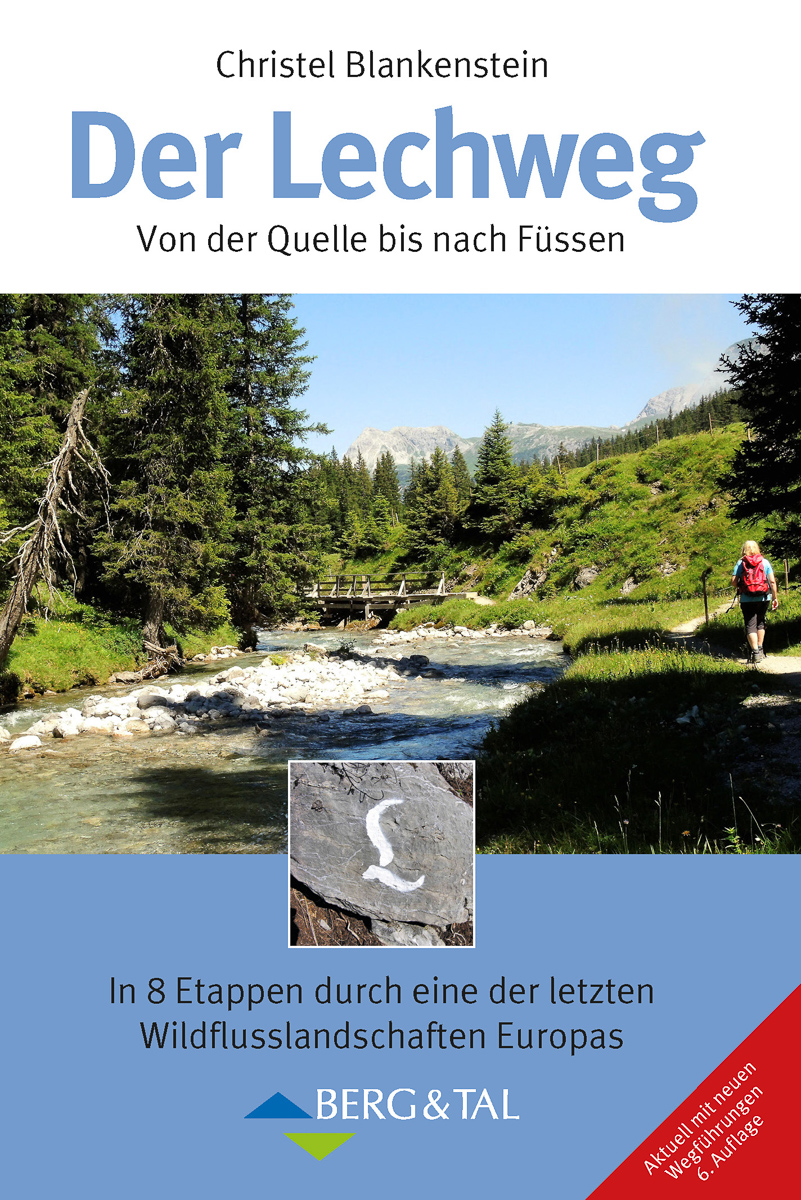
<p> Wandelgids van de 125km lange Lechweg van Lech am Arlberg tot Füssen in de Allgäu.</p> <div> Der Lechweg. Großartige Wildflußlandschaft in Europa, In 8 Etappen von der Quelle bis nach Füssen. Übersichtskarte, Routenkarten - Christel Blankenstein - Berg & Tal Verlag</div> <div> </div> <div> <div> Der am 15. Juni 2012 eröffnete Lechweg erschließt auf rund 125 Kilometern die herrliche Gebirgslandschaft vom Quellgebiet des Lechs bis zum Lechfall in Füssen.</div> <div> </div> <div> In 8 Etappen – mehr oder weniger sind möglich – durchwandert man bei Lech am Arlberg das reizvolle Hochtal des jungen Flusses, gelangt hinab ins Tiroler Lechtal mit seiner großartigen Wildflusslandschaft, die eine der letzten in Europa ist, und wechselt schließlich ins deutsche Ostallgäu mit den weltberühmten Königsschlössern Neuschwanstein und Hohenschwangau. Der Weg verläuft auf leichten bis mittelschweren Wegen sehr abwechslungsreich am Fluss, dann wieder an den Talhängen entlang und ist für Anfänger ebenso geeignet wie für trainierte Senioren.</div> <div> </div> <div> Die Autorin ist den Weg in voller Länge gegangen und hat neben genauen Wegbeschreibungen in beiden Richtungen viel Sehens- und Wissenswertes zusammengetragen. Ferner gibt sie Hinweise auf ebenfalls leichte Extra-Touren, da man die Etappen auch sehr gut von einem Standquartier aus absolvieren kann. Alle nötigen Angaben wie Übernachtungsverzeichnis, Anreise, Ausrüstung etc. finden sich ebenfalls in dem schön bebilderten Buch.</div> </div> <p> </p>
€17,50
Bekijk product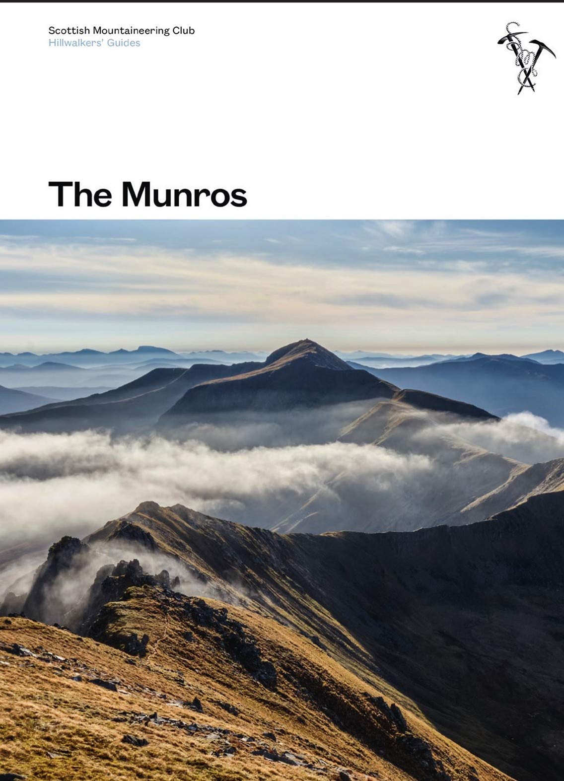
<p> Toonaangevend boek over alle Munros in Schotland, de bergen boven de 3000 feet. Er zijn talloze mensen die in hun leven alle Munros willen beklimmen; het is een hele cultus.</p> <div> This fully revised edition of the Scottish Mountaineering Club’s original and best-selling guidebook The Munros describes the best walking routes on Scotland’s 282 mountains above 3000ft.</div> <div> </div> <div> Comprehensive descriptions in this definitive guide recommend ascent and descent routes for each of the Munros and their 226 subsidiary Tops, with maps of the peaks and principal surrounding hills to help you plan the most enjoyable journeys through Scotland’s wild landscape. The descriptions are brought to life throughout with vivid photography that illustrates the dramatic beauty of these much-loved mountains.</div> <div> </div> <div> In addition to routes themselves the book contains Munros Tables, a complete list of the 508 Munros and subsidiary Tops, listed in height order. Whether you are an occasional walker looking for inspiration or a dedicated Munroist planning to tick off your next peak, The Munros is essential reading for anyhillwalking enthusiast.</div>
€37,95
Bekijk product
<p> Deze gids geeft een goede beschrijving van de lange afstands route. De kaarten zijn schetsmatig maar wel duidelijk.</p> <div> <div> The Rob Roy Way is one of Scotland's Great Trails and is very popular with both walkers and cyclists. It runs through many places linked with Scotland's most famous outlaw, Rob Roy MacGregor (1671-1734). The route starts at Drymen (near Glasgow) and ends at Pitlochry in the eastern Highlands, so it takes you away from the crowds following the West Highland Way to some of Scotland's finest lochs and glens.</div> <div> </div> <div> Its main spine runs for 79 miles (127 km) and is waymarked. There is an optional extra 17 miles if you take the wilderness extension through Glen Almond and Glen Quaich. Most walkers complete it in 6-8 days and most cyclists in 3-4 days.</div> <div> </div> <div> The main route goes through Loch Ard forest to Aberfoyle, goes beside Lochs Venachar, Lubnaig and Tay and passes through superb scenery, with interesting aqueducts, viaducts and a 3600 year-old stone circle. The terrain is a mixture of forest tracks, cycleway, disused railway trackbed and moorland footpaths. The Way passes through a succession of friendly villages with welcoming pubs and B&Bs.</div> <div> </div> <div> Our fourth edition has more content, with full coverage for cyclists and detailed description of the Glen Quaich alternative. It is now longer, 80 pages in place of 64, with 111 colour photos, many of them fresh. However thanks to its robust perfect binding it is 10 grams lighter than the previous edition and more pocketable.</div> <div> </div> <p> This guidebook contains all that walkers and cyclists need to plan and enjoy the Rob Roy Way:</p> <ul> <li> details of distance, terrain and food/drink for walkers and cyclists</li> <li> eight-page section for the extension via Glen Quaich</li> <li> visitor attractions, side-trips and mountains to climb including Ben Ledi</li> <li> planning information for travel by car, train, bus or plane</li> <li> concise biography of Rob Roy MacGregor</li> <li> background on pre-history, heritage and wildlife</li> <li> detailed mapping on 18 pages at 1:50,000in full colour, with 111 colour photos</li> </ul> </div> <p> </p>
€22,50
Bekijk product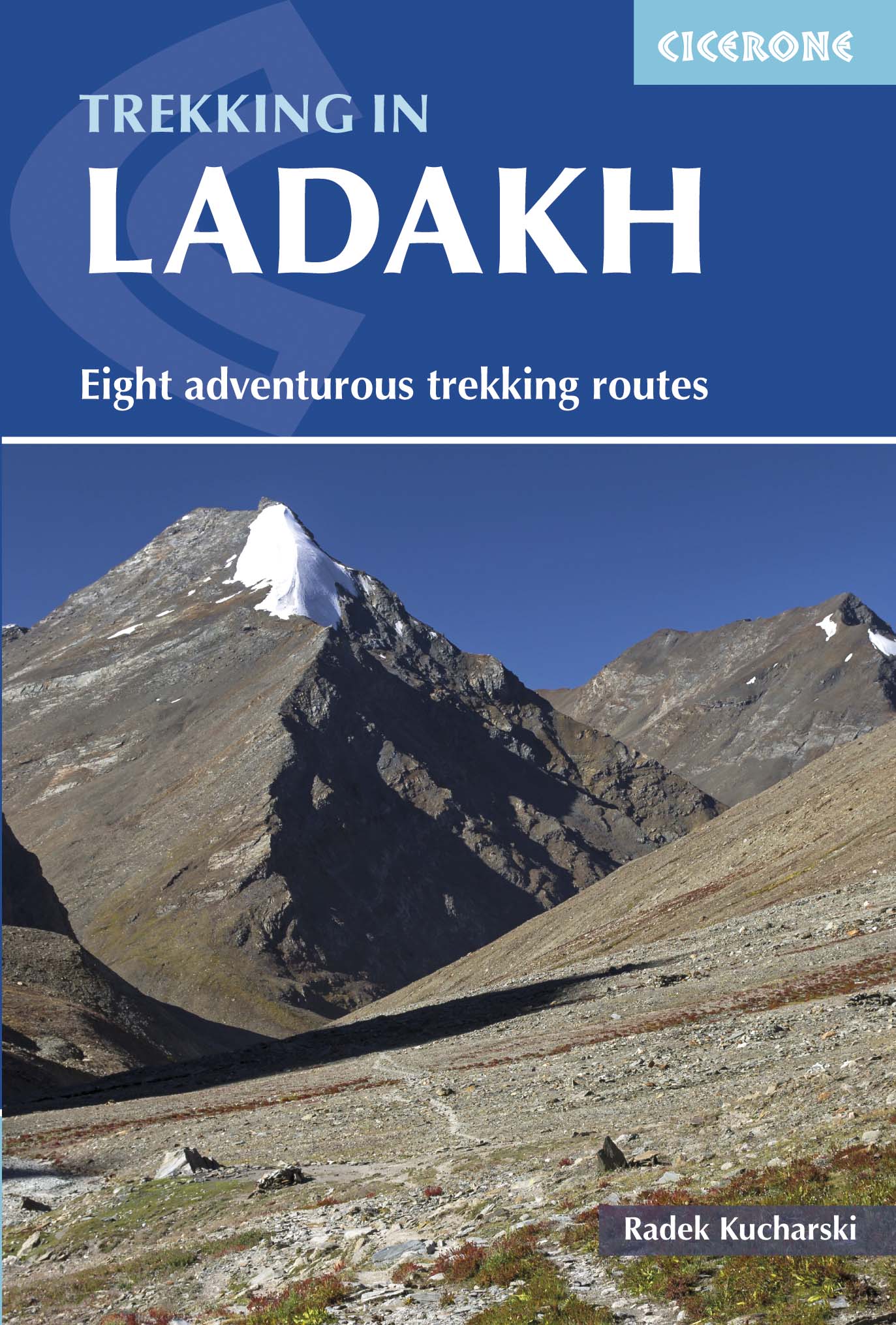
<p> Cicerone wandelgids van Ladakh met acht uitdagende trekkingen. </p> <div> </div> <div> <div> This trekking guidebook gives detailed descriptions of eight different treks across the Ladakh, Zanskar and Markha Valley in northern India. Ranging from moderate difficulty to very demanding, each trek is broken down into multiple stages, and has information on difficulty, available accommodation and access, as well as the many combinations and alternative routes open to exploration. </div> <div> </div> <div> Known as Little Tibet; for both its landscape and culture, Ladakh lies at the northern tip of India. The region is bisected by the great River Indus and neighbours Tibet and Kashmir. This quiet corner of the Himalaya has developed a strong trekking culture over recent years for adventurous trekkers. Trekking in this remote, high-altitude region is extremely challenging, as paths are not signed and there are only a limited number of villages. However, its magnificent landscape (a huge area full of limitless trekking possibilities), hospitable people, rich heritage and limited number of tourists make Ladakh an amazing destination. </div> <div> </div> <div> The guide includes background information on local culture, history and religion, as well as all the planning detail you need on crucial aspects such as environmental responsibility, health and safety in the mountains, trekking practicalities and preparation for altitude.</div> <div> </div> <div> Activities</div> <div> Moderate to very demanding trekking.</div> <div> </div> <div> Seasons</div> <div> Unlike other parts of the Himalayas, Ladakh is not normally hit by the Monsoon. Therefore summer (June to September) is the best trekking season.</div> <div> </div> <div> Centres</div> <div> Access is through Leh, the capital of Ladakh. The treks travel through towns and villages all over the Ladakh region, as well as the Zanskar sub-region and the Phukthal and Karsha monasteries.</div> <div> </div> <div> Difficulty</div> <div> High altitude, lack of lodges and restaurants as well as the remoteness of the region make trekking in Ladakh a rather challenging activity. Moderate to very demanding treks have been covered in the book. A number of local agencies can help organise the trip and make the trek much easier.</div> <div> </div> <div> Must See</div> <div> The rich Tibetan-style culture, remote mountains, high passes, serene monasteries and Ladakhi people. See K2 from the Kanji Pass. Cover the classic Darcha-Padum-Lamayuru trek. Trace snow leopards and venture up deep river gorges.</div> </div> <p> </p>
€33,95
Bekijk product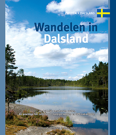
<p> Dalsland, dat is ‘Zweden in het klein’, wordt wel beweerd. Je vindt er alles wat Zweden te bieden heeft, allemaal op goed bereikbare afstand. De beste manier om te ontdekken wat Dalsland te bieden heeft, is door erop uit te trekken in de weidse natuur. Met deze gids in je hand heb je de beschikking over twintig gedetailleerd beschreven rondwandelingen, variërend in duur van een paar uur tot een hele dag. De wandelingen zijn verspreid over de hele provincie, zodat er altijd wel een paar in de buurt zijn.</p> <p> Het boekje, met 20 wandelingen, 82 prachtige full colour foto's van alle bezienswaardigheden, handige kaarten en GPS-coördinaten</p>
€16,95
Bekijk product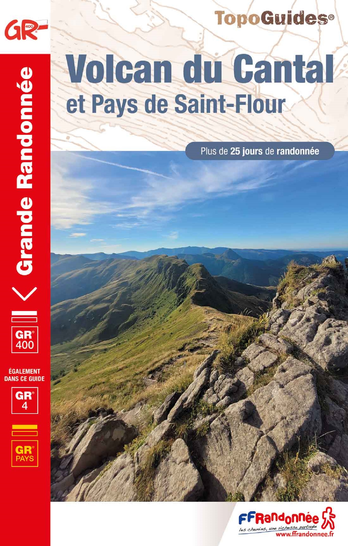
<p> Franstalige wandelgids. Uitstekende beschrijving met gedetailleerd kaartmateriaal (topografisch, IGN) en veel praktische informatie over zwaarte, hoogte en hutten. Bijna onmisbaar voor het lopen van deze route. In andere beschrijvingen zijn geen goede kaarten bijgevoegd! De gids bevat een lijst met overnachtingsadressen inclusief telefoonnummers en vaak aangevuld met websites/mailadressen. Wij leveren er een beknopte Frans-Nederlandse woordenlijst bij.</p> <div> Avec un diamètre d'environ 70 km, le massif cantalien est l'un des plus importants d'Europe. Pics, monts et planèzes ont pris la place de l'énorme volcan des origines. Lentement érodée, cette région montagneuse est devenue un immense pâturage d'altitude qui se couvre de fleurs au printemps : ancolies, lis, digitales, gentianes.</div> <div> </div> <div> Plus à l'Est, perchée sur son promontoire de basalte, St-Flour garde au travers de son évêché et se sa cathédrale le souvenir jaloux de sa prospérité passée. Elle est la porte qui permet d'accéder aux sommets aplanis et parsemés de blocs de granit de la Margeride (boucle à parcourir en 6 jours), aux gorges de la Truyère (boucle à parcourir en 5 jours) et au plateau basaltique de la Planèze (boucle à parcourir en 4 jours).</div>
€19,95
Bekijk product
<p> Franstalige wandelgids met een beschrijving van een aantal dagtochten. Uitstekende beschrijvingen met duidelijk kaartmateriaal, hiervoor zijn de topografische kaarten gebruikt van IGN. Mislopen is nauwelijks mogelijk, maar ja .. de franse taal! Ook praktische informatie staat in deze gids. Alle gidsen bevatten een door ons toegevoegde uitgebreide frans - nederlandse wandelwoordenlijst.</p> <p> Plaines ou montagnes, de Bourg-en-Bresse au pays de Gex. </p> <p> Découvrir l'Ain demande du temps, de la patience et une certaine idée du voyage : la cité médiévale de Pérouges et ses ruelles pavées dans lesquelles se répand l'odeur de la galette toute chaude ; l'église de Brou avec ses tuiles vernissées, chef d'oeuvre de l'art gothique flamboyant ; le curieux village d'Oncieu bâti en rond autour d'un verger et l'imposant panorama sur le Mont-Blanc, à contempler depuis les sommets de la plus haute chaîne du Jura au-dessus de la plaine du Léman, qui est également une réserve naturelle.</p> <div> Ces 46 circuits satisferont aussi bien les randonneurs sportifs, qui pourront gravir les 1 710 m du Crêt de la Neige que les amateurs de promenades bucoliques qui apprécieront la fraîcheur des étangs de la Bresse.</div>
€18,95
Bekijk product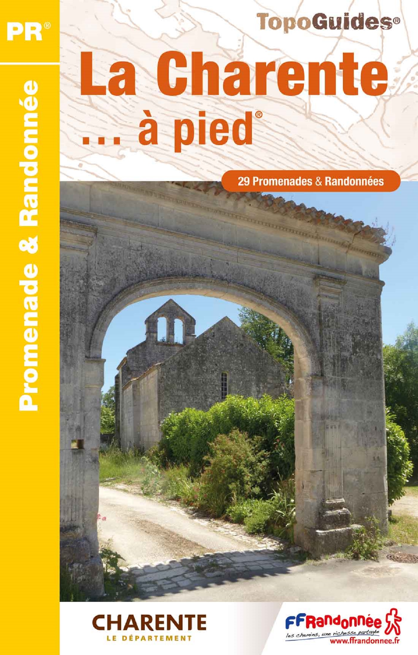
<p> Franstalige wandelgids met een beschrijving van een aantal dagtochten. Uitstekende beschrijvingen met duidelijk kaartmateriaal, hiervoor zijn de topografische kaarten gebruikt van IGN. Mislopen is nauwelijks mogelijk, maar ja .. de franse taal! Ook praktische informatie staat in deze gids. Alle gidsen bevatten een door ons toegevoegde uitgebreide frans - nederlandse wandelwoordenlijst.</p> <p> Le territoire charentais s'identifie souvent à son fleuve. Pierre Boujut, tonnelier-poète à Jarnac, traduit le sentiment que lui inspire son cours familier : "La Charente n'est pas un fleuve civilisé, ni un fleuve sauvage. La Charente est un fleuve heureux..." Et si le fleuve est roi, la pierre est reine : cathédrale et remparts d'Angoulême, dolmens, abbayes romanes, donjons fortifiés racontent l'histoire à leur manière. </p>
€18,95
Bekijk product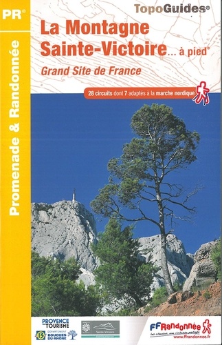
<p> Franstalige wandelgids met een beschrijving van een aantal dagtochten. Uitstekende beschrijvingen met duidelijk kaartmateriaal. Mislopen is nauwelijks mogelijk, maar ja .. de franse taal! Ook praktische informatie staat in deze gids. Alle gidsen bevatten een door ons toegevoegde uitgebreide frans - nederlandse wandelwoordenlijst.</p> <p> Au-dessus d'Aix, un élégant vaisseau calcaire qui a inspiré l'œuvre de Cézanne. </p> <p> Caillou "usé" cher au peintre Cézanne, le blanc massif calcaire de la Sainte-Victoire est un élément symbolique de la Provence et un terrain d'évolution très convoité pour les loisirs de plein air.</p> <div> Labellisé "Grand Site de France" et "Site natura 2000", cette montagne a vu la mise en place de politiques de conservation d'espèces rares, en particulier des chauves-souris, reptiles et amphibiens. Trois milieux naturels caractérisent le massif : pelouse, garrigue et bois de chênes verts. En fonction des saisons, le randonneur pourra reconnaître quelques espèces courantes : iris, ciste cotonneux, lys martagon, ophrys de Provence...</div> <div> </div> <div> Parmi les circuits proposés, les marcheurs ne manqueront pas de grimper jusqu'à la Croix de Provence (point culminant à 946 m) ou de découvrir en famille l'étonnant site de Roques-Hautes, l'un des plus riches gisements d'oeufs de dinosaures au monde.</div>
€18,95
Bekijk product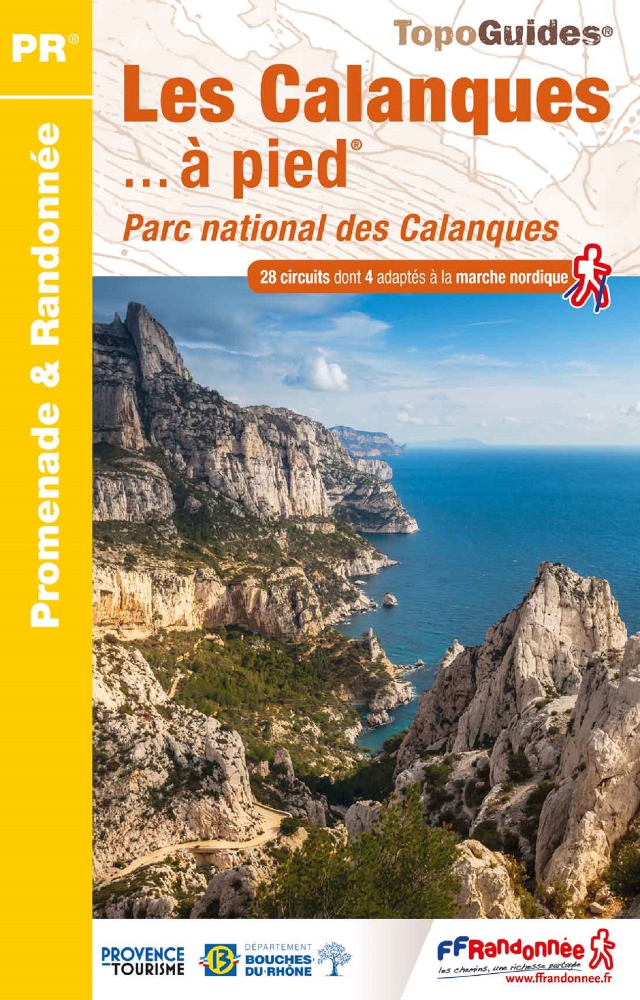
<p> Franstalige wandelgids met een beschrijving van een aantal dagtochten. Uitstekende beschrijvingen met duidelijk kaartmateriaal. Mislopen is nauwelijks mogelijk, maar ja .. de franse taal! Ook praktische informatie staat in deze gids. Alle gidsen bevatten een door ons toegevoegde uitgebreide frans - nederlandse wandelwoordenlijst.</p> <div> De Marseille à Cassis, 20 km de Calanques (Sormiou, Port-Pin...) bordant une mer d'un bleu azur. 28 randonnées dans un décor méditerranéen emblématique, petites criques, ports de pêche, falaises blanches et pins maritimes forment un décor authentique invitant à la promenade. De nombreux spots offrent un panorama exceptionnel sur les Calanques : vallon d'En-Vau, mont du Liminy, falaises du Devenson</div>
€17,95
Bekijk product