
Beantwoord enkele vragen, en binnen seconden geeft AI je een persoonlijk aankoopadvies op maat.
Beantwoord enkele vragen, en binnen seconden geeft AI je een persoonlijk aankoopadvies op maat.

<div> Real OS maps 1:25,000</div> <div> </div> <div> The definitive two-way guide to the Hadrian’s Wall Path: both eastbound and westbound routes are described in full.</div> <div> </div> <div> <div> Hadrian's Wall was one of the Romans' most ambitious structures. When completed, it ran for 73 miles between the west and east coasts of Northern England. It crossed the crags and hills of some of Britain's wildest and most beautiful terrain.</div> <div> </div> <div> The Hadrian's Wall path is one of England's official 'National Trails'. It leads you on an unforgettable journey of discovery along the route of the Wall. Discover the incredible surviving sections of the Wall and its forts, milecastles and turrets.</div> <div> </div> <div> This definitive two-way guide to the Hadrian's Wall Path contains real OS mapping at 1:25,000 and both eastbound and westbound routes are described in full. There are 14 different itineraries with schedules of 3, 4, 5, 6, 7, 8 and 9 days for walkers and runners and the guide includes both northbound and southbound itineraries. Difficult calculations of time, distance and altitude gain are done for you.</div> <div> </div> <div> Also includes:* Extraordinary detail on the history and construction of Hadrian's Wall* Section on the unmissable forts of Hadrian's Wall* Detailed information on equipment and travelling light* Everything the trekker needs to know: route, costs, difficulty, weather, travel, and more* Full accommodation listings: the best inns, B&Bs and hotels* Information for both self-guided and guided trekkers* Numbered waypoints linking the Real Maps to our clear descriptions</div> </div> <p> </p>
€19,50
Bekijk product
<p> Uitstekende wandelgids van een gerenommeerde Engelse uitgever. De tochten zijn met zorg beschreven en voorzien van allerhande nuttige informatie.</p> <p> Italy's Alta Via 1, a 180km hiking trail through the Italian Alps following the northern flank of the Aosta Valley, boasts magnificent views of the Alpine giants: Mont Blanc, the Matterhorn, the Grand Combin and Monte Rosa. Indeed, it is sometimes known as the Giants' Trail and can be combined with a sister-route, the Alta Via 2 (covered in a separate Cicerone guide), which runs along the southern flank of the valley, to form the Tor des Geants. Stretching from Donnas to Courmayeur, the Alta Via 1 offers fantastic alpine walking, with welcoming refuges and small hotels providing overnight accommodation (and great food) along the way. The guide presents the route in two sections, for the advantage of those who can't spare the full fortnight-plus needed to walk the entire AV1. The trail is described in 16 stages, with alternative stages covering some popular variants, including an optional detour to visit the famed monastery at the Great St Bernard Pass. Each stage includes clear route description and mapping, plus notes on local points of interest and accommodation options. An alternative itinerary, list of useful contacts, kitlist and glossary can be found in the appendices.</p>
€23,95
Bekijk product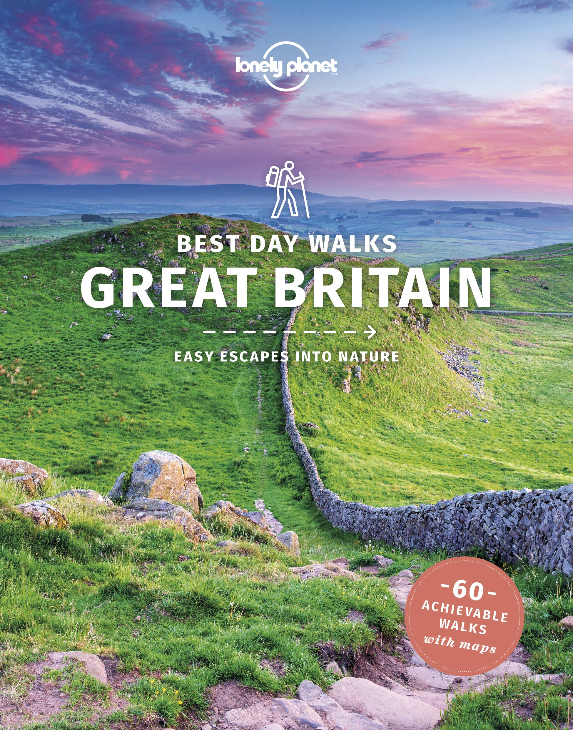
<p> Lonely Planet heeft een nieuwe serie uitgebracht: Best Day Walks in verschillende landen. Het zijn de - door Lonely Planet uitgekozen - mooiste wandelingen verspreid over het land. Goed beschreven, met een schetsmatige kaart erbij ... het werkt heel stimulerend met mooie foto's!</p> <div> Lonely Planet's Best Day Walks Great Britain is your passport to 60 easy escapes into nature. Stretch your legs outside the city by picking a hike that works for you, from a few hours to a full day, from easy to hard. Cross misty moors, hike wild landscapes, and explore the highlands. Get to the heart of Great Britain and begin your journey now!</div> <div> </div> <div> Inside Lonely Planet's Best Day Walks Great Britain Travel Guide:</div> <div> </div> <div> Colour maps and images throughout</div> <div> </div> <div> Special features - on Great Britain's highlights for walkers, kid-friendly walks, accessible trails and what to take</div> <div> Best for… section helps you plan your trip and select walks that appeal to your interests</div> <div> Region profiles cover when to go, where to stay, what's on, cultural insights, and local food and drink recommendations to refuel and refresh. Featured regions include:</div> <div> Cumbria & the Lakes, Devon & Cornwall, Southwest England, Northern England, Central England, Southeast & East England, London, Scotland, Wales</div> <div> </div> <div> Essential info at your fingertips - walk itineraries accompanied by illustrative maps are combined with details about walk duration, distance, terrain, start/end locations and difficulty (classified as easy, easy-moderate, moderate, moderate-hard, or hard)</div> <div> </div> <div> Over 70 maps</div>
€22,50
Bekijk product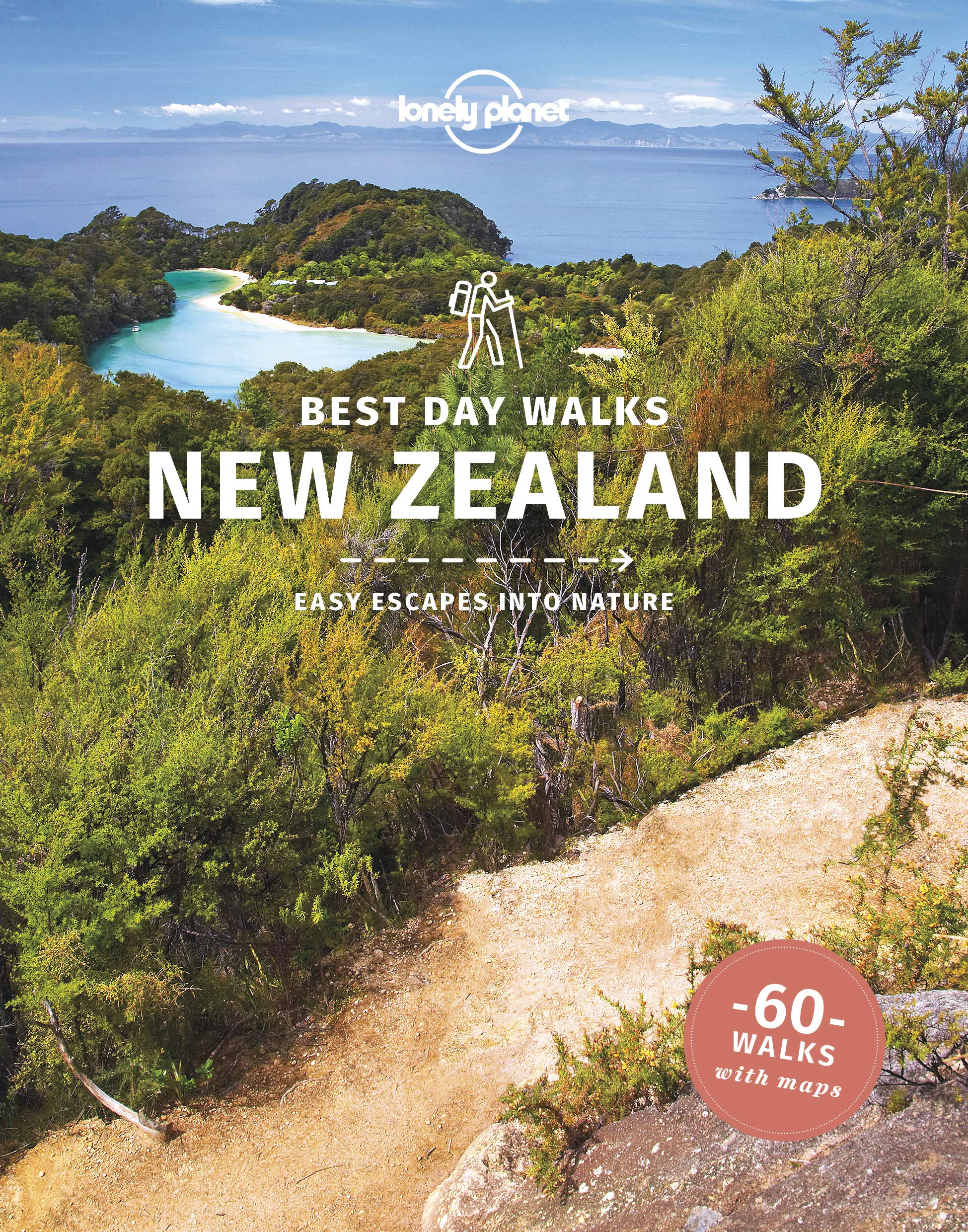
<p> Lonely Planet heeft een nieuwe serie uitgebracht: Best Day Walks in verschillende landen. Het zijn de - door Lonely Planet uitgekozen - mooiste wandelingen verspreid over het land. Goed beschreven, met een schetsmatige kaart erbij ... het werkt heel stimulerend met mooie foto's!</p> <div> Lonely Planet's Best Day Walks New Zealand is your passport to 60 easy escapes into nature. Stretch your legs outside the city by picking a hike that works for you, from a few hours to a full day, from easy to hard. Climb ancient volcanoes, view amazing vistas, and scale tall mountains. Get to the heart of New Zealand and begin your journey now!</div> <div> </div> <div> </div> <div> </div> <div> Inside Lonely Planet's Best Day Walks New Zealand Travel Guide:</div> <div> </div> <div> Up-to-date information - all businesses were rechecked before publication to ensure they are still open after 2020’s COVID-19 outbreak</div> <div> </div> <div> Colour maps and images throughout</div> <div> </div> <div> Special features - on New Zealand's highlights for walkers, kid-friendly walks, accessible trails and what to take</div> <div> </div> <div> Best for… section helps you plan your trip and select walks that appeal to your interests</div> <div> Region profiles cover when to go, where to stay, what's on, cultural insights, and local food and drink recommendations to refuel and refresh. Featured regions include:</div> <div> The North, Central North Island, Southern North Island, Top of the South, Canterbury, West Coast, Otago, The South</div> <div> </div> <div> Essential info at your fingertips - walk itineraries accompanied by illustrative maps are combined with details about walk duration, distance, terrain, start/end locations and difficulty (classified as easy, easy-moderate, moderate, moderate-hard, or hard)</div> <div> </div> <div> Over 65 maps</div>
€22,50
Bekijk product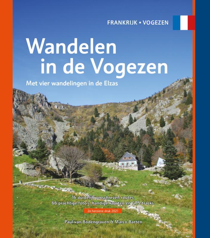
<p> Gids met 16 rondwandelingen in de Vogezen (waarvan vier in de Elzas). Routebeschrijving, kaart, foto's en GPS-tracks. Als je vanuit Nederland of België komt, vind je de eerste èchte bergen in de Vogezen, in het noordoosten van Frankrijk. Met toppen die tot boven de boomgrens reiken, kun je hier je conditie en uithoudingsvermogen beproeven op de vele wandelpaden langs de hellingen. Die zijn nooit te steil om niet gewoon te kunnen lopen, maar uitdagend en betoverend mooi. Bovenop word je beloond met de mooiste vergezichten. Op heldere dagen kijk je tot ver in de buurlanden. Maar ook als je eens een dagje niet de bergen in wilt, vind je wel een of meerdere tochten die niet direct een aanslag doen op de kuitspieren. Groene valleien langs slingerende beken en rivieren vormen het decor voor wat gemakkelijkere tochten. Of maak een wandeling door de wijngaarden aan de oostkant van de bergketen, op het randje met de Elzas. Gecombineerd met een bezoekje aan een van de vele wijnstadjes is zo’n wandeling ook een fantastische manier om de charmes van de Vogezen te ontdekken. De wandelingen in deze gids lopen overwegend in het oostelijke, bergachtige deel van de Vogezen en aan het randje van de Elzas. Het is juist de combinatie van ruige natuur en wijncultuur die een bezoek aan deze regio zo de moeite waard maken. Frankrijk kent een lange en uitgebreide wandelinfrastructuur en er lopen dan ook heel wat routes en langeafstandspaden door het departement. De 16 rondwandelingen in deze gids brengen je naar een paar van de mooiste plekken, over prachtige paden. Pittig, maar zeer zeker ook lonend. Geniet ervan!</p>
€15,95
Bekijk product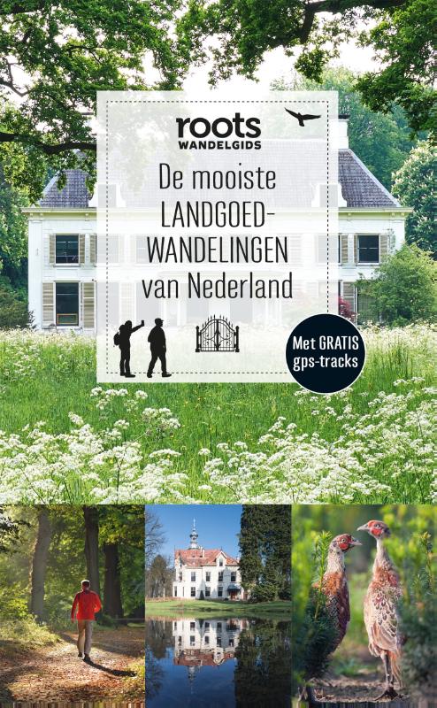
<p> Nederland is rijk aan landgoederen en gelukkig zijn veel landgoederen opengesteld voor wandelaars. In 'De mooiste0landgoedwandelingen van Nederland' vind je 16 wandelroutes en 4 landgoedommetjes over en langs de fraaiste landgoederen die ons land kent. Ontdek in het voorjaar hoe de stinsenplanten bloeien op het Groningse Landgoed Fraeylemaborg of geniet in de winter van de sfeervolle rust op het Veluwse landgoed Oud-Groevenbeek.0Daarnaast toont deze gids je welke dieren en planten karakteristiek zijn voor landgoederen en de omringende natuurgebieden. Via handige veldgidspagina's vind je talloze portretten: van vleermuis tot muurvaren en van ree tot kievitsbloem. En kun je geen genoeg krijgen van het monumentale groen? Deze gids geeft nog eens 11 extra landgoederen en buitenplaatsen waar het goed toeven is.</p>
€15,99
Bekijk product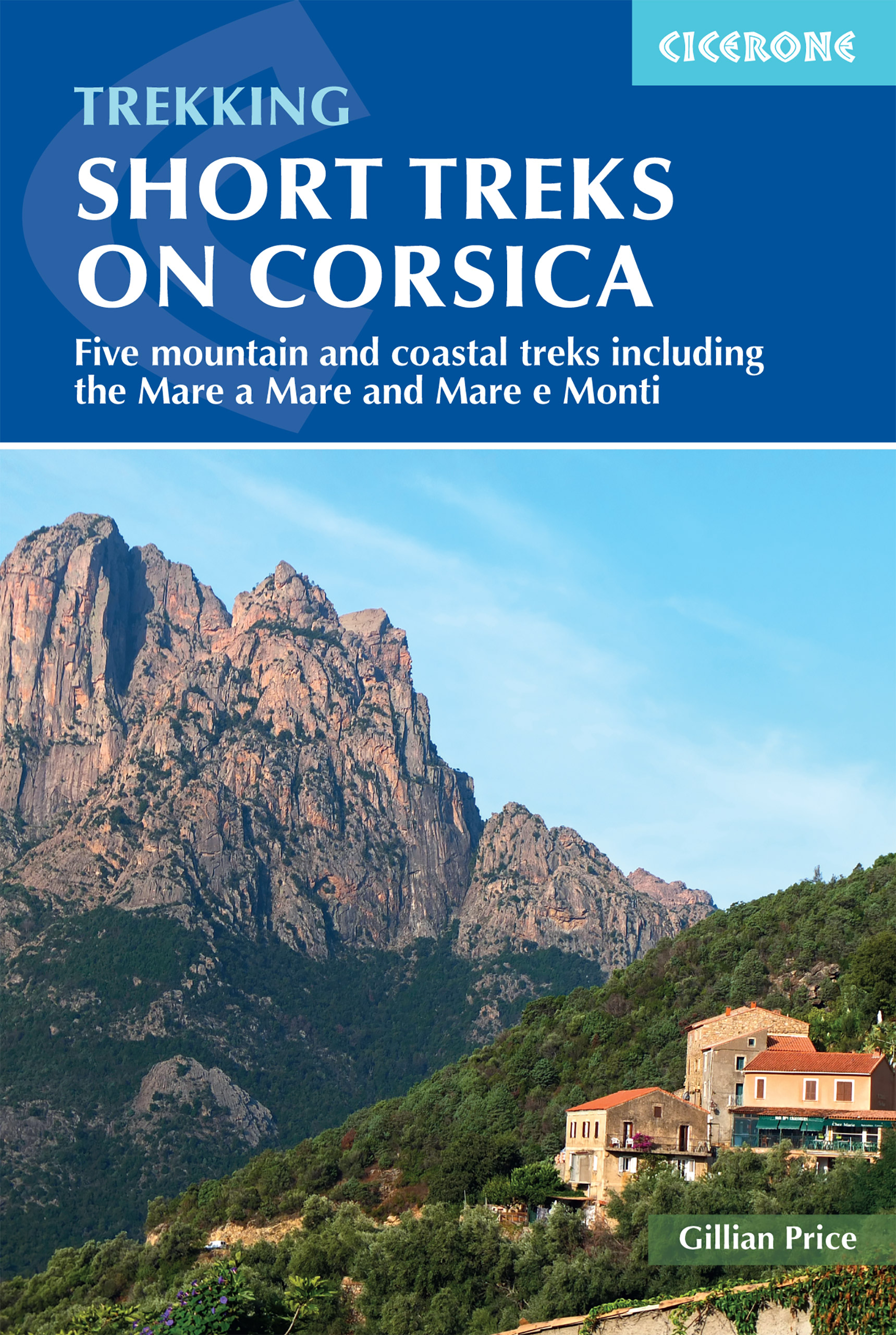
<p> Uitstekende wandelgids van dit geweldige gebied. goed beschreven met veel praktische informatie om de route te kunnen lopen, inclusief redelijke kaarten.</p> <p> With spectacular mountain landscapes, beautiful rugged coast, forests, maquis and striking river gorges, Corsica is a walker's paradise. This guidebook details five of the islands's most popular shorter treks: the 2-day coastal Sentier du Douanier (Customs Officer's Path) around Cap Corse; two coast-to-coast routes through the central mountains, the 11-day Mare a Mare Nord and the 5-day Mare a Mare Sud; and two 'coast and mountains' routes, the 10-day Mare e Monti and the 5-day Mare e Monti Sud. (Corsica's famous 190km GR20 trail is described in a separate Cicerone guide.) The routes can be linked to create longer excursions and accommodation is provided by a mixture of walkers' hostels, B&Bs and hotels; camping is also an option. The guide presents each of the waymarked trails in daily stages averaging around 12-13km per day, with route description, mapping and notes on accommodation options.</p> <p> There is advice on how to get to Corsica, when to go and what to take, plus accommodation listings, useful contacts and a French/Corsican-English glossary. The guide also offers a wealth of information about the island's rich plant and wildlife. Considerably easier than the challenging GR20, these trails offer a more accessible option for trekkers wishing to experience the 'real' Corsica, away from the bustling coastal resorts. You'll find enchanting scenery - towering forests, gushing cascades, turquoise coves, aromatic maquis, rugged mountains and quiet villages nestling on hillsides of chestnut woods - not to mention a favourable climate and delicious local cuisine. Don't be surprised if you fall under the island's spell!</p>
€23,95
Bekijk product
<p> Let Op Franstalig!</p> <p> Wandelgids van de Transardennaise en de Transfamenne. Het boekje bevat alleen beschrijvingen (in het Frans) en geen kaartjes. Daarnaast worden 12 wandelingen in de ardennen beschreven. Deze routes hebben wel kleine overzichtskaartjes.</p> <p> Lente 1992: eerste editie van La Transardennaise. Bijna dertig jaar later, met meer dan 15.000 gedistribueerde boeken - in het Frans en Nederlands - is hier een nieuwe editie van deze essentiële gids voor degenen die "niet idioot willen lopen". Routes, bovendien goed aangegeven, praktisch advies en vooral een schat aan informatie over het lokale erfgoed, zowel natuurlijk als cultureel, tastbaar en immaterieel: overzicht van fauna, flora en hulpbronnen; beschrijving en geschiedenis van opmerkelijke gebouwen of locaties; gegevens over de taal en levensstijl van de inwoners, enz. Deze nieuwe editie is bedoeld om nog dichter bij de ontdekking van de Ardennen te staan, door meer te focussen op hun overtuigingen, hun festivals en legendes. En voor de minder atletische of gezinnen met kinderen, biedt het boek een tiental luswandelingen waarvan de lengte varieert tussen 4,7 en 14 km zonder de Transfamenne te vergeten, of 57 km wandelen.</p>
€17,90
Bekijk product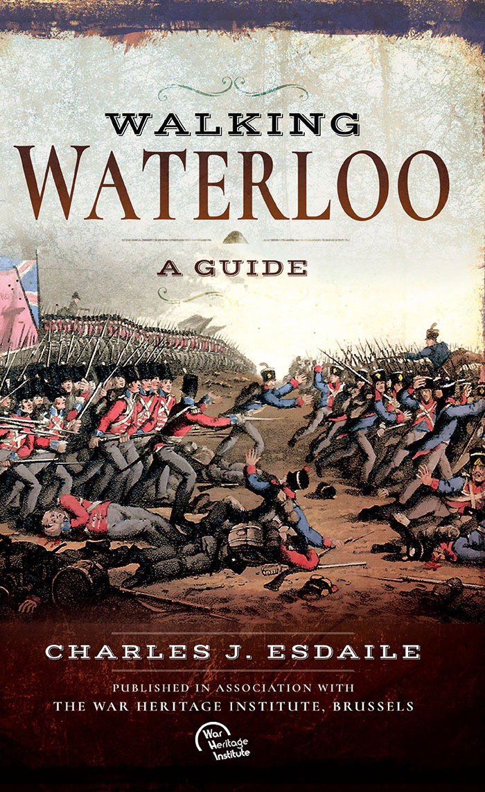
<div> Wandelgids over de Slag bij Waterloo</div> <div> </div> <div> Charles Esdaile’s new guide to the Battle of Waterloo presents the experience of the soldiers who took part in the battle in the most graphic and direct way possible – through their own words. In a series of walks he describes in vivid detail what happened in each location on 18 June 1815 and he quotes at length from eyewitness accounts of the men who were there.</div> <div> </div> <div> Each phase of the action during that momentous day is covered, from the initial French attacks and the intense fighting at Hougoumont and La Haye Sainte to the charges of the French cavalry against the British squares and the final, doomed attack of Napoleon’s Imperial Guard.</div> <div> </div> <div> This innovative guide to this historic site is fully illustrated with a selection of archive images from the War Heritage Institute in Brussels, modern colour photographs of the battlefield as it appears today and specially commissioned maps which allow the visitor to follow the course of the battle on the ground.</div>
€24,95
Bekijk product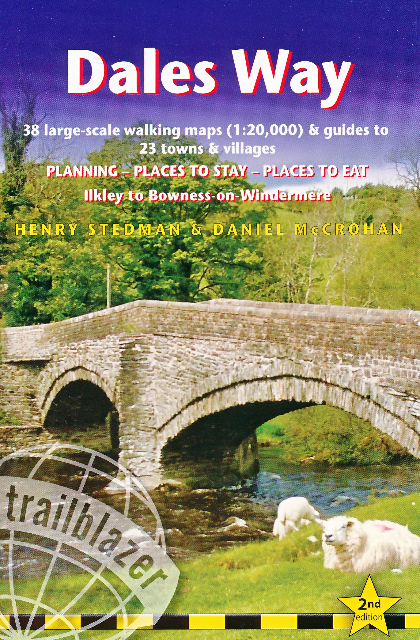
<p> The popular Dales Way long-distance footpath begins in Ilkley, West Yorkshire and runs for 84 miles (135km) to end in the Lake District, in Bowness-on-Windermere. It follows riverside paths along the River Wharf towards Ribblehead and the watershed of northern England, then meanders along the river valleys of Dentdale, the River Mint and the River Kent dropping down into the Lake District to end beside Lake Windermere. It's a relatively easy walk that takes about a week.</p> <p> Includes 40 large-scale maps (3 1/8 inches to 1 mile); 9 town plans and 8 overview maps. Full details of all accommodations and campsites, restaurants and pubs; plus full public transport information. Plus day-walks. - 40 large-scale walking maps - at just under 1:20,000 - showing route times, places to stay, points of interest and much more - 9 town plans - 8 area maps and trail profiles - Itineraries for all walkers - whether walking the route in its entirety over a week or sampling the highlights on day walks and short breaks - Practical information for all budgets - camping, bunkhouses, hostels, B&Bs, pubs and hotels; Ilkley to Bowness-on-Windermere - where to stay, where to eat, what to see, plus detailed street plans - Comprehensive public transport information - for all access points on the Dales Way. - Flora and fauna - four page full color flower guide, plus an illustrated section on local wildlife - Green hiking - understanding the local environment and minimizing our impact on it - Includes downloadable gps waypoints</p>
€19,95
Bekijk product