
Beantwoord enkele vragen, en binnen seconden geeft AI je een persoonlijk aankoopadvies op maat.
Beantwoord enkele vragen, en binnen seconden geeft AI je een persoonlijk aankoopadvies op maat.
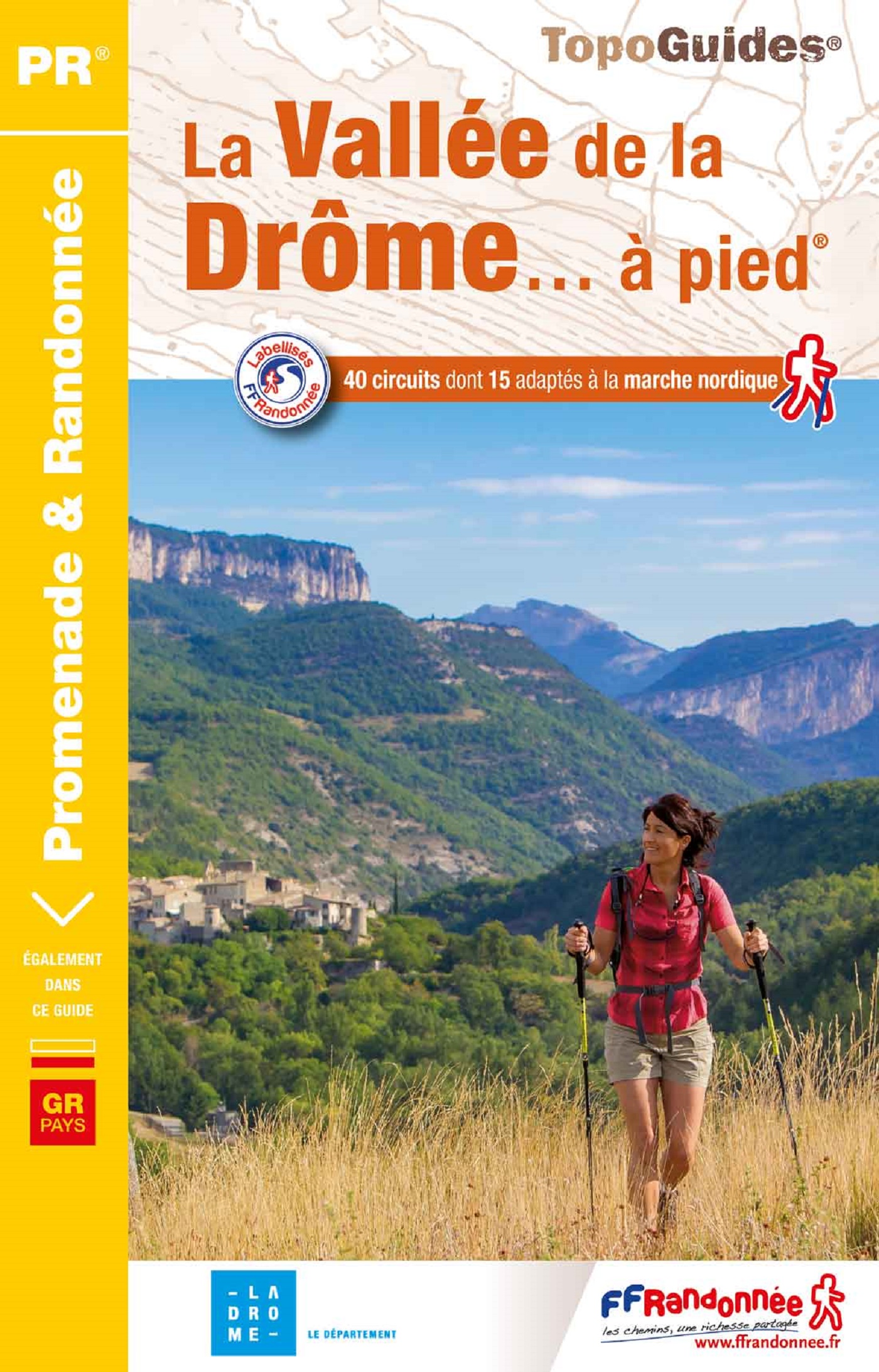
<p> Franstalige wandelgids met een beschrijving van een aantal dagtochten. Uitstekende beschrijvingen met duidelijk kaartmateriaal. Mislopen is nauwelijks mogelijk, maar ja .. de franse taal! Ook praktische informatie staat in deze gids. Alle gidsen bevatten een door ons toegevoegde uitgebreide frans - nederlandse wandelwoordenlijst.</p> <p> Entre les forêts, les grandes et lumineuses falaises, les canyons sauvages où coulent des eaux cristallines, les pelouses préalpines et les garrigues inondées d’un soleil déjà provençal, le Pays de Gervanne, marqué par la beauté majestueuse des vallées de la Drôme, dévoile une palette de paysages et de milieux naturels aussi variés que contrastés. </p>
€18,50
Bekijk product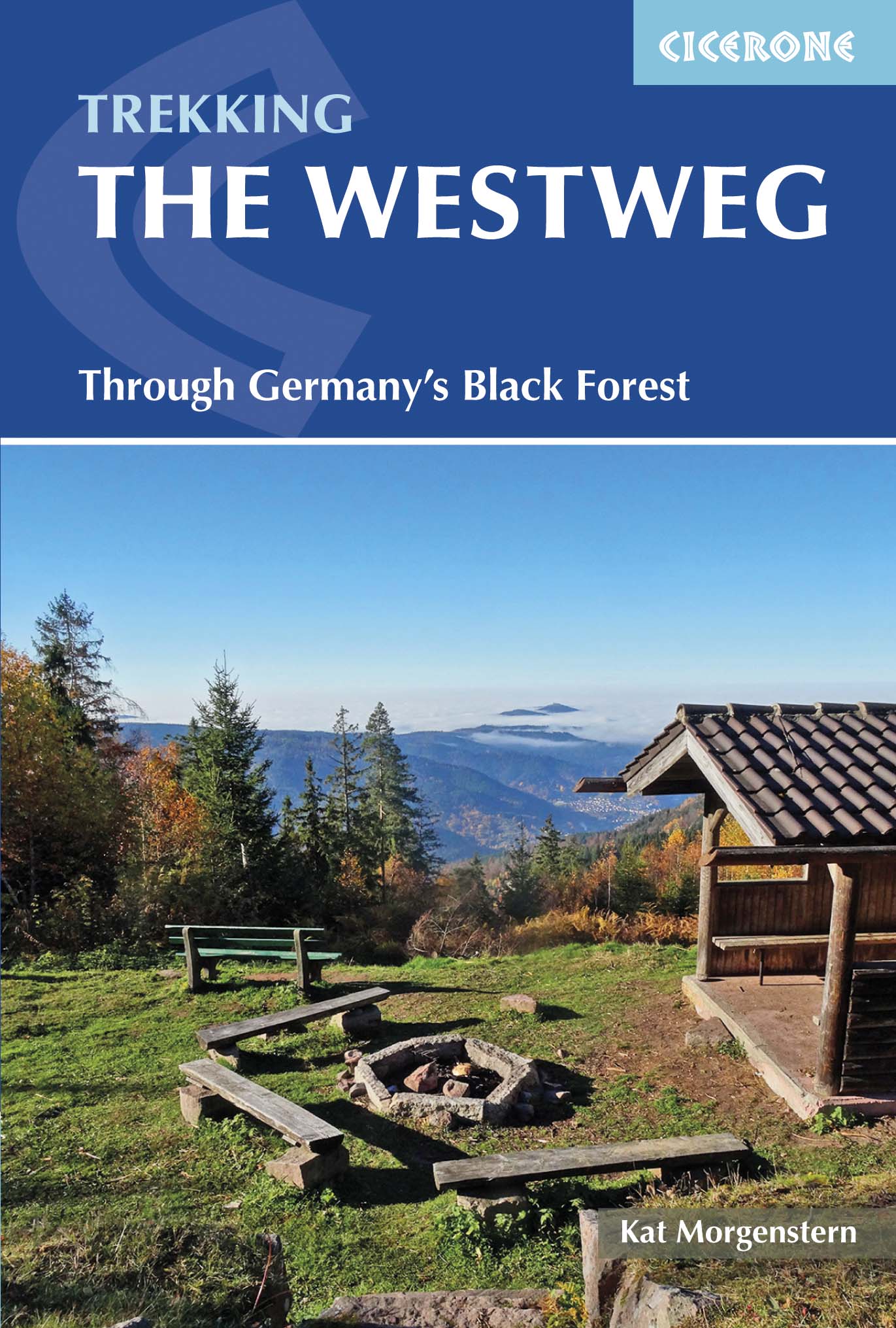
<p> Uitstekende wandelgids van een meerdaagse tocht in het Zwarte Woud in Duitsland. Goede beschrijvingen, veel praktische informatie en redelijke kaarten al zullen deze niet helemaal voldoende zijn.</p> <p> Guidebook to the Westweg (Westway), a 285km walk across Germany's Black Forest from Pforzheim to Basel. This classic route, which includes Feldberg, Black Forest's highest peak, takes 13 to 14 days, each day stage ranging from 15 to 28km. Two variants are described, both well way-marked and suitable for those new to long distance walking.</p> <div> This guidebook is all you need to discover The Westweg, a 285km walk along the length Germany's Black Forest from Pforzheim to Basel. This classic long-distance trail takes around two weeks to walk, in stages of 15-28km. The route is well way-marked and suitable for experienced hikers and those new to long distance walking, though some sections are steep. The Westweg incorporates many of the region's highlights, such the Schwarzwald National Park, the source of the Danube and Lake Titisee. At Titisee there is a choice to make: the western route taking in the Black Forest's highest peak Feldberg and the vineyards of the Markgräflerland, or the quieter eastern route via the Herzogenhorn peak and on to Basel, with all its cultural attractions and old-world charm.</div> <div> </div> <div> With well-maintained and waymarked trails, an efficient public transport system and conveniently placed huts and farmhouse inns, the Black Forest is one of Germany's best-loved walking destinations. Soft-contoured, forest-clad hills, interspersed with pastures and picturesque villages combine on with far-ranging vistas right across the Alpine chain.</div> <div> </div> <div> Detailed descriptions and 1:100,000 maps accompany each stage of the route and the book describes options for shortening stages using public transport. There is also information on when to go, where to stay and a German-English glossary - all of which will earn this useful guide a place in your rucksack.</div>
€23,95
Bekijk product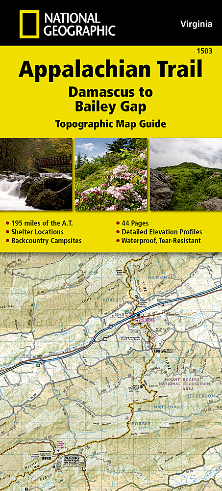
<p> Wandelgids/wandelatlas met weinig tekst, maar goede kaarten van een gedeelte van de Appalachian Trail.</p> <div> The Damascus to Bailey Gap Topographic Map Guide makes a perfect traveling companion when traversing the southwest Virginia section of the Appalachian Trail (A.T.). The A.T. in southwest Virginia travels through a culturally and historically rich area that includes fertile farmland, long, wooded ridges, and the highest mountains in the state. While the Mt. Rogers high country, just east of Damascus, is very popular with visitors, hikers can find excellent opportunities for solitude farther north on their way to the New River and Bailey Gap.</div> <div> </div> <div> Scale 1/63 360 (1 cm = 633 m). 1 inch = 1 mile.</div> <div> </div> <div> This topographic Map Guide is printed on a waterproof, tear-resistant paper. A full UTM grid is printed on the map to aid with GPS navigation.</div> <div> </div> <div> Each A.T. Topographic Map Guide includes detailed topographic maps at a detail of 1 inch = 1 mile. Each page is centered on the A.T. and overlaps with the adjacent pages so there is little chance of getting lost. Along the bottom of each page is a trail profile that shows the distance between shelters, camping areas, and trail access points. The map and trail profile provide a step by step visual guide to hiking the trail, mile by rugged mile. The Topographic Map Guide is built for all levels of hiking enthusiasts, from the day tripper to the multi month 'thru-hiker'. The front pages of the printed Topographic Map Guide include resupply information, town inset maps, camping options, and much more.</div>
€16,95
Bekijk product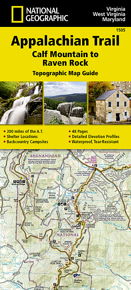
<p> Wandelgids/wandelatlas met weinig tekst, maar goede kaarten van een gedeelte van de Appalachian Trail.</p> <div> The Calf Mountain to Raven Rock Topographic Map Guide makes a perfect traveling companion when traversing the northern Virginia section of the Appalachian Trail (A.T.). The map covers the area between the southern tip of Shenandoah National Park and the Maryland-Pennsylvania state line and gives hikers an excellent opportunity to experience the Blue Ridge Mountains while still remaining relatively close to towns and highways.</div> <div> </div> <div> Scale 1/63 360 (1 cm = 633 m). 1 inch = 1 mile.</div> <div> </div> <div> This topographic Map Guide is printed on a waterproof, tear-resistant paper. A full UTM grid is printed on the map to aid with GPS navigation.</div> <div> </div> <div> Each A.T. Topographic Map Guide includes detailed topographic maps at a detail of 1 inch = 1 mile. Each page is centered on the A.T. and overlaps with the adjacent pages so there is little chance of getting lost. Along the bottom of each page is a trail profile that shows the distance between shelters, camping areas, and trail access points. The map and trail profile provide a step by step visual guide to hiking the trail, mile by rugged mile. The Topographic Map Guide is built for all levels of hiking enthusiasts, from the day tripper to the multi month 'thru-hiker'. The front pages of the printed Topographic Map Guide include resupply information, town inset maps, camping options, and much more.</div>
€16,95
Bekijk product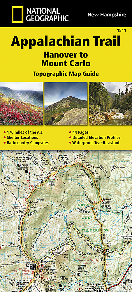
<p> Wandelgids/wandelatlas met weinig tekst, maar goede kaarten van een gedeelte van de Appalachian Trail. </p> <p> Each A.T. Topographic Map Guide includes detailed topographic maps at a detail of 1 inch = 1 mile. Each page is centered on the A.T. and overlaps with the adjacent pages so there is little chance of getting lost. Along the bottom of each page is a trail profile that shows the distance between shelters, camping areas, and trail access points. The map and trail profile provide a step by step visual guide to hiking the trail, mile by rugged mile. The Topographic Map Guide is built for all levels of hiking enthusiasts, from the day tripper to the multi month 'thru-hiker'. The front pages of the printed Topographic Map Guide include resupply information, town inset maps, camping options, and much more.</p> <div> The Hanover to Mount Carlo Topographic Map Guide makes a perfect traveling companion when traversing the New Hampshire section of the Appalachian Trail (A.T.). The A.T. through New Hampshire is considered one of the more challenging sections of the trail, with long stretches above tree line and the possibility for rapid temperature change and snow any month of the year. But despite its difficulty, the trail offers some of the most spectacular scenery in New England as it leaves the Connecticut River valley to traverse the beautifully rugged White Mountains, a highlight of the A.T.</div> <div> </div> <div> Scale 1/63 360 (1 cm = 633 m). 1 inch = 1 mile.</div> <div> </div> <div> This topographic Map Guide is printed on a waterproof, tear-resistant paper. A full UTM grid is printed on the map to aid with GPS navigation.</div>
€16,95
Bekijk product
<p> Wandelgids/wandelatlas met weinig tekst, maar goede kaarten van een gedeelte van de Appalachian Trail. </p> <p> Each A.T. Topographic Map Guide includes detailed topographic maps at a detail of 1 inch = 1 mile. Each page is centered on the A.T. and overlaps with the adjacent pages so there is little chance of getting lost. Along the bottom of each page is a trail profile that shows the distance between shelters, camping areas, and trail access points. The map and trail profile provide a step by step visual guide to hiking the trail, mile by rugged mile. The Topographic Map Guide is built for all levels of hiking enthusiasts, from the day tripper to the multi month 'thru-hiker'. The front pages of the printed Topographic Map Guide include resupply information, town inset maps, camping options, and much more.</p> <div> The Mount Carlo to Pleasant Pond Topographic Map Guide makes a perfect traveling companion when traversing the southern Maine section of the Appalachian Trail (A.T.). The A.T. through Maine offers some of the most challenging sections of trail along the A.T., both in rugged terrain and weather conditions, and is not recommended for the unprepared hiker.</div> <div> </div> <div> Scale 1/63 360 (1 cm = 633 m). 1 inch = 1 mile.</div> <div> </div> <div> This topographic Map Guide is printed on a waterproof, tear-resistant paper. A full UTM grid is printed on the map to aid with GPS navigation.</div>
€16,95
Bekijk product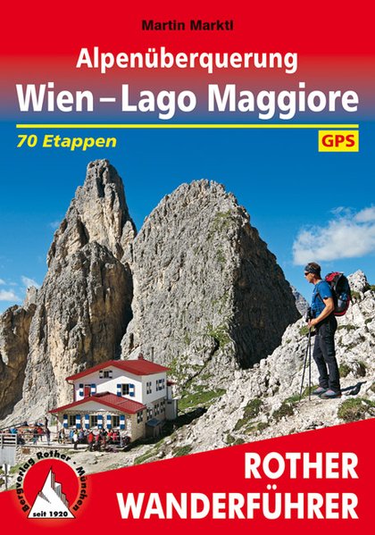
<p> Goede wandelgids met kaartmateriaal, hoogteprofielen en praktische informatie. Duitstalig.</p> <p> Einmal einen ganzen Sommer lang Auszeit in den Bergen nehmen, ohne jede Eile die Natur und die Freiheit genießen ... Davon träumt wohl jeder ambitionierte Wanderer, und auf die besonders Ambitionierten wartet jetzt eine ganz besondere Herausforderung: zu Fuß über die Alpen, aber der Länge nach! In 70 Tagen von Wien bis zu den Oberitalienischen Seen, von Hütte zu Hütte, von Gipfel zu Gipfel, von einem landschaftlichen Highlight zum nächsten. Die vom Autor selbst konzipierte Weitwanderroute am wetterbegünstigten Südrand der Alpen wird im Rother Wanderführer »Wien – Lago Maggiore« erstmals präsentiert.<br /> Stolze 1300 Kilometer lang ist diese Tour der Superlative, 70.000 schweißtreibende Höhenmeter gilt es zu bewältigen, 4 Alpenstaaten – Österreich, Slowenien, Italien und die Schweiz – werden durchwandert, knapp 20 Gebirgsgruppen durch- und überschritten, unzählige bekannte und weniger bekannte Fernwanderwege gekreuzt. Unzählbar sind auch die Möglichkeiten, in urigen Hütten und Gasthäusern gemütliche Stunden zu verbringen und die Energiespeicher mit regionalen Spezialitäten aus Küche und Keller wieder aufzufüllen.<br /> Der Autor Martin Marktl hat bereits mehrere Tausend Weitwander-Kilometer in den Beinen. Von dieser umfassenden Erfahrung profitieren seine Leser durch die vielen Praxistipps für die Vorbereitung einer derartigen Unternehmung. Detaillierte Informationen zur Infrastruktur am Weg, insbesondere zu Einkehr und Nächtigung sowie Anbindung an öffentliche Verkehrsmittel, erleichtern die Planung der einzelnen Etappen und die eventuelle Aufteilung des Fernwanderweges auf mehrere Urlaube. Verlässliche Wegbeschreibungen sowie Wanderkärtchen und Höhenprofile helfen unterwegs weiter, zudem stehen auf der Internetseite des Bergverlag Rother GPS-Tracks zum Download bereit.</p>
€21,95
Bekijk product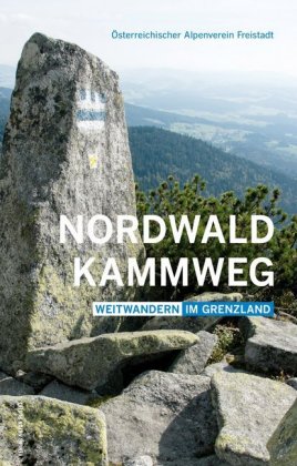
<p> Goede gedetailleerde beschrijving van deze lange-afstands-wandelroute in het Oostenrijkse grensgebied van Duitsland - Tsjechie - Oostenrijk. Met veel kaarten (niet altijd genoeg detail, wandelkaart nodig) en praktische informatie als hoogteprofielen en beschrijving van de route. </p> <p> Der durch mystische Landschaften entlang der transkontinentalen Wasserscheide verlaufende Nordwaldkammweg an der tschechisch-österreichischen Grenze ist der älteste Weitwanderweg Österreichs. Er führt vom Dreisesselberg in Bayern zum Nebelstein in Niederösterreich und umfasst gemeinsam mit dem neuen Rückweg durch Südböhmen 14 Tagesetappen bei einer Gesamtlänge von rund 340 Kilometern. Der Weg führt durch nordisch anmutende, dichte, dunkle, moosige Wälder wie den Böhmerwald und den Sternwald, aber auch durch sehr liebliche Landstriche mit Wiesen und Weilern. Die höchsten Erhebungen sind der Dreisesselberg (1 312 m), der Plöckenstein (1 379 m), der Sternstein (1 122 m), der Viehberg (1 111 m) und derNebelstein (1 015 m). Der vorliegende neue Wanderführer beinhaltet erstmals auch den Rückweg durch das Grüne Band Europas (Nordwaldkammweg II und III).</p>
€24,95
Bekijk product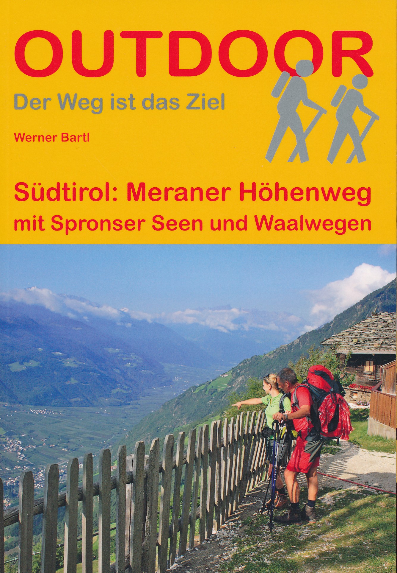
<p> Compacte Duitstalige wandelgids van de bergtocht boven Merano. Deze route is bijna 100km lang en voert om de NP Texelgruppe heen. Deze gids bevat kleine kaartjes en gedetailleerde routeinformatie en de gegevens van de diverse overnachtingsmogelijkheden. </p> <div> In deze gids is de complete 5-daagse route beschreven. Het is ook mogelijk om maar een klein stuk van de route te lopen, bijvoorbeeld langs de Spronser berg meren en rivieren.</div> <div> </div> <div> Am Meraner Höhenweg wandern Sie auf einem Rundwanderweg 89 km um den Naturpark Texelgruppe. Der Nordteil (38 km) des Weges führt durch das Pfossental ins Hochgebirge zum höchsten Punkt am Eisjöchl (2.895) und ist gesamt von Ende Mai (nach der Schneeschmelze) bis Oktober (vor Schneefall) begehbar. Im Südteil (51 km) befinden Sie sich im Mittelgebirge und sind von Mai bis November auf gut gesicherten Wegen durch verschiedene Vegetationszonen unterwegs. Auf manchen Etappen wandern Sie lange Strecken ohne große Höhenunterschiede. Der schönste Panoramaweg Südtirols bringt Sie im abwechslungsreichem Auf und Ab zu Talböden mit Wasserfällen und als Steig auf den höchsten Punkt am Eisjöchl (2898). Bei der Umrundung der Texelgruppe mit den spitzen Dreitausendern wandern Sie mit Blick ins Meraner Becken, Passeiertal und Sarntaler-, Stubaier- und Ötztaler Alpen durch Bergwiesen von Hof zu Hof. Sie durchqueren Wälder und immer wieder eröffnen sich neue Ausblicke. Der Weg kann in fünf bis sechs Tagesetappen mit je 6 – 8 Stunden Gehzeit bewältigt werden. Auch Varianten mit kürzeren Etappen sind möglich, da es zahlreiche Einstiege und Abstiege, sowie Seilbahnen gibt, die Sie direkt zum Höhenweg auf 1.300 bis 1.500 m bringen. Auch eine Alternative mit Durchquerung des Naturparkes über die Spronser Gebirgsseen und Waalwege werden beschrieben.</div>
€15,50
Bekijk product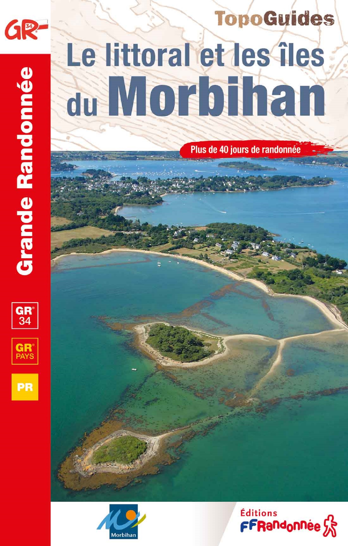
<p> Fout lopen wordt op deze manier wel erg moeilijk. Met symbolen is weergegeven welke voorzieningen (openbaar vervoer / winkels / overnachtingen) er zijn langs of bij de route. Een nadeel is dat de daadwerkelijke adressen dan weer niet altijd genoemd worden. Alle gidsen bevatten een door ons toegevoegde uitgebreide frans nederlandse wandelwoordenlijst.</p> <p> Découverte de la partie sud du Morbihan (la "petite mer") et ses grands sites : flânez dans les villes au passé prestigieux comme Lorient ou Vannes, arpentez les bords du golfe, ses îles (île aux Moines, Arz) et ses paysages magiques, longez l'océan sur la presqu'île de Rhuys, laissez vous fasciner par la sauvage Quiberon ou par les mégalithes de Carnac et Locmariaquer, respirez l'air du large à Belle-Ile, Groix, Houat et Hoëdic... Le mythique GR® 34est complété ici par 19 circuits en boucle, offrant un large choix de randonnées en famille.</p>
€19,95
Bekijk product