
Beantwoord enkele vragen, en binnen seconden geeft AI je een persoonlijk aankoopadvies op maat.
Beantwoord enkele vragen, en binnen seconden geeft AI je een persoonlijk aankoopadvies op maat.
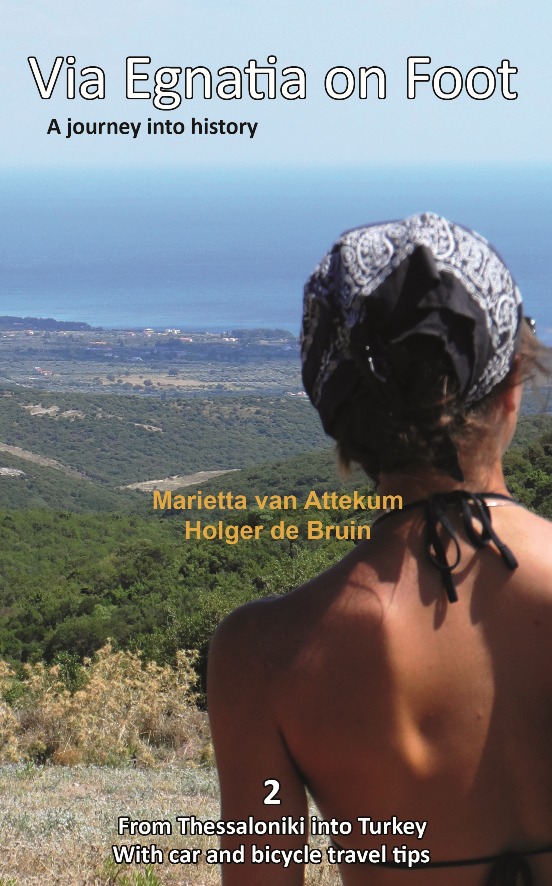
<div> Via Egnatia on foot, Part 2, covers a distance of more than 550 kilometers. The book starts just as our first book with practical tips for travellers (chapter 1) and a description of the history of the Via Egnatia (chapter 2). In chapter 3 all relevant aspects of the trail are described in a general way. For instance conditions of the road, description of the landscape and the practical use of the maps. In chapter 4 you will find detailed information on the original Via Egnatia stages of the trail; long distances are cut up into separate walking sections. Each stage/section provides a description and a map of the track, interesting historical and cultural facts and monuments, illustrated with beautiful pictures. At the end we present the traveller two options to enter Turkey: one leads you to Edirne, the other one crosses the border to Ipsala.</div> <div> </div> <div> In general this trail is not difficult for walkers, although after heavy rain it may be less easy and circumstances may differ considerably, so some improvisation can be requested. Although our description aims at walkers, in chapter 5 we include special information for people who want to discover the Via Egnatia by bike or by car. In chapter 6 we give information on the historical and actual background of the region.</div> <div> </div> <div> Both Via Egnatia books are meant for the traveller who is interested in the history and culture of the Balkans. The landscape is beautiful, there are many remnants of the interesting past, people are hospitable as ever, so you can expect a wonderful experience. If you want to know more about the people along the road and their history, you can find suggestions for further reading in appendix B. In appendix A we have included a list with useful words and expressions in Greek and in Turkish, so you will be able to communicate at a basic level with the people you meet on the way.</div>
€22,95
Bekijk product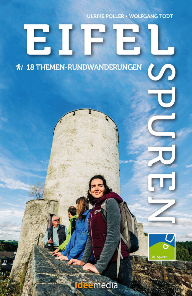
<div> Stille Wege, lauschige Täler, kulturelle Höhepunkte: 18 Eifelspuren machen Lust, die reizvolle Naturlandschaft vor den Toren von Aachen und Köln zu Fuß neu zu entdecken. Von leicht bis sportlich, von 3 bis 21 Kilometern ist für jeden Geschmack ein Themenweg für einen perfekten Wandertag dabei. Die meisten Wege sind den öffentlichen Nahverkehr angeschlossen. Für die Anfahrt mit dem Auto zu den teils versteckt liegenden Parkplätzen enthält das Buch ausführliche Wegbeschreibungen, QR-Codes machen in Verbindung mit Smartphones die Navigation besonders einfach, ausführliche Wegbeschreibungen die Touren nahezu unverlaufbar.</div> <div> </div> <div> Auf 18 neuen Themen-Rundwanderwegen werden Eifelträume wahr: Die Eifelspuren bieten mit Touren zwischen 3 und 21 Kilometern Wanderspaß für jeden Geschmack. Ausführliche wie übersichtliche Anfahrts- und Wegbeschreibungen, GPS-Daten, eine Direktanbindung an die App "traumtouren" und viele Fotos machen bereits die Auswahl und Vorbereitung jeder Tour besonders einfach.</div>
€16,95
Bekijk product<div> This good looking, modern walking book will take you on ten short circular themed walks across South Wales’ ever-popular Brecon Beacons National Park.</div> <div> </div> <div> The Brecon Beacons was Britain’s 10th National Park, established in 1957 to preserve and highlight the unique landscape of the area. The Brecon Beacons are said to be named after the historical practice of lighting beacons of fire upon hilltops to forewarn neighbouring valleys of invasion. </div> <div> </div> <div> The Brecon Beacons cover 1,344 square kilometres / 519 square miles with it’s spectacular waterfalls, valleys and expanse of hilly terrain; the Black Mountain to the west, the Fforest Fawr Geopark, Waterfall Country and the Pen y Fan range at the centre, and The Black Mountains to the east.</div> <div> </div> <div> The variety of flora and fauna is as vast as the landscape. Rare sub-arctic, alpine plants thrive within this unique climate. Mammals you’re likely to spot include include wild mountain ponies, horseshoe bats, otters and water voles. Often seen birds of prey include the buzzard and iconic red kite.</div> <div> </div> <div> It’s a wonderful area for walking and for everyone with a love of the outdoors.</div>
€10,95
Bekijk product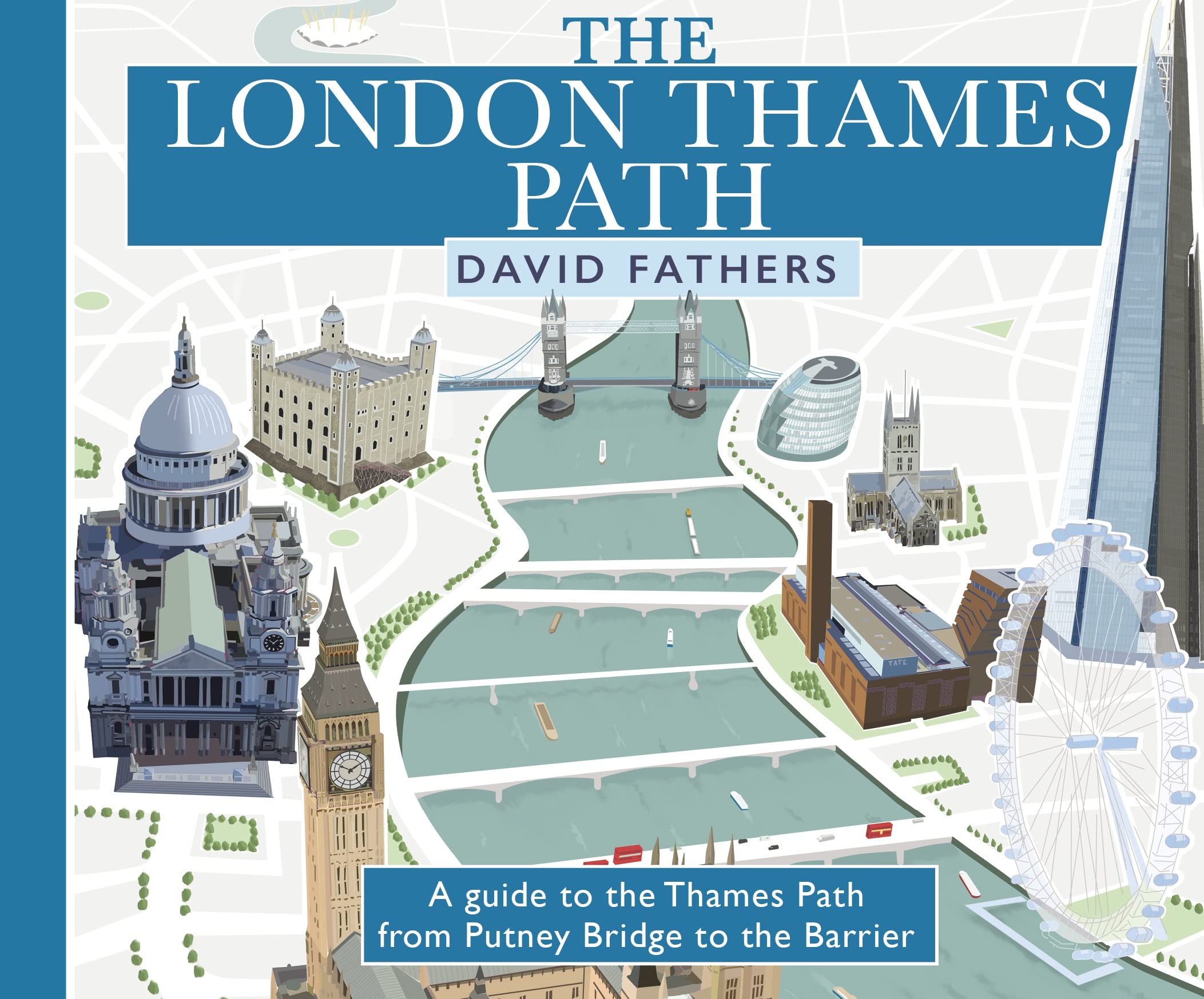
<p> <b>David Fathers presents a unique and richly illustrated guide to the London section of the Thames Path, newly updated to reflect the city's ever-changing landscape.</b><br /> <br /> The iconic path, which stretches from the lost floodplains of Richmond all the way to the Thames Barrier, is a <b>panoramic 40-mile walk through 2000 years of London's history</b>.</p> <ul> <li> From the<b> old docks </b>and wharves that primed the Industrial Revolution, through the<b> heart of British Government</b>, Monarchy and Church to the City of London that took its very existence from the river.</li> <li> From the site of the Putney Debates at St Mary's Church to Wren's mighty baroque cathedral of St Paul's.</li> <li> From the great Victorian engineering works of Sir Joseph Bazalgette and his attempts to clean up a polluted London and the river to the Thames Barrier seeking to protect huge parts of London from rising sea levels.</li> <li> From London Bridge, site of the oldest crossing point, to the Millennium Bridge, the Thames' newest crossing. </li> </ul> <p> This book explains the<b> panorama we see today,</b> what came before and how the changes came about. <b>Each double page shows the distance covered</b> so you can plan your own tour of the river.</p>
€16,50
Bekijk product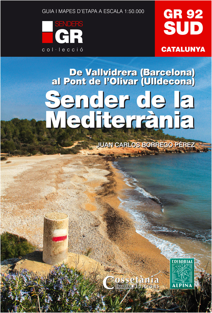
<div> Wandelgids met een wandelkaartenset van deze uitdagende route van het zuidelijk deel van de GR92 in Catalonie. De route begint in Vallvidrera, vlakbij Barcelona, en eindigt in Pont de l'Olivar op grens van Catalonië tussen Barcelona en Valencia in. </div> <div> </div> <div> De route is uitstekend beschreven in een handige, beetje zware gids in ringband. Wel in het Catalaans! Op de kaarten met schaal 1:50.000 is de route duidelijk ingetekend; je zou wellicht het boek thuis kunnen laten.</div> <div> </div> <div> Van de uitgever: De GR 92 volgt de Catalaanse kust en imiteert het oude pad van alle beschavingen, zowel degenen die een pad gebruikten om van de Pyreneeën af te dalen naar de Ebro en de Via Herculea, de Via Augusta, de Camino de France, de Camino de Valencia, de N -340 of de modernere AP-7. Het verschil ligt in het feit dat al deze wegen zijn ontworpen voor communicatie over land en de GR 92 is een oversteekplaats te voet om speels te genieten van de kustlandschappen van het land. In het geval van de GR 92 Sud de Collserola, de Llobregat-vallei, de kust van het Garraf-massief, het kustgebergte, de Camp de Tarragona, de Costa Daurada, de Delta de l'Ebre, de Serra de Montsià en de Foia d 'Ulldeacona'</div>
€30,95
Bekijk product
<div> Wandelgids met een wandelkaartenset van deze uitdagende route in Andorra. </div> <div> </div> <div> De route is uitstekend beschreven in een handige gids in ringband. Wel in het Catalaans Spaans! Op de kaarten met schaal 1:40.000 is de route duidelijk ingetekend; je zou wellicht het boek thuis kunnen laten.</div> <div> </div> <div> De lengte en de grootsheid van deze route van de Gran Recorregut del País (GRP)-route is dusdanig dat veel bergwandelaars het erover eens zijn dat als je deze route niet hebt gelopen, je het Prinsdom Andorra niet echt goed kent. Het is een route van in het totaal zo'n 115 km en met een cumulatief hoogteverschil van 8.500 m. Dit allemaal tesamen geeft een cirkel (Travessa Cicrculair) door een land waar de bergen nooit lijken te eindigen. Deze publicatie bestaat uit een gids (Catalaans) en 4 kaarten op schaal 1:40.000 met de technische moeilijkheden en de profielen van de 7 etappes van de traverse.</div>
€25,95
Bekijk product
<div> Everybody can explore Snowdonia, from England and Wales’ highest mountain to magical medieval castles and the spectacular Conwy coastline, with these accessible, family-friendly walks. Get outside and active with the whole family amidst the mysterious legends and natural beauty of Snowdonia.</div> <div> </div> <div> Snowdonia Short Walks Made Easy include:</div> <div> </div> <div> - Take Victorian tramcars or the chairlift to the summit of the Great Orme, then wander wildflower-rich meadows for incredible views of the mountains, the sea and the Isle of Anglesey</div> <div> - Follow the Lôn Gwyrfai trail round beautiful Llyn y Gader through Beddgelert Forest to the lovely village, with views of Snowdon and Y Garn throughout</div> <div> - Get off the beaten track in the valley of Cwm Penamnen with views of the cliffs of Moel Sabod and the 13th-century Dolwyddelan castle</div> <div> - Discover Porthmadog on a fascinating walk over Borth-y-Gest headland, the ingenious Cob and the salt marshes home to many seabirds</div> <div> - Explore Dolgellau and the riverside walk to Penmaenpool along the Mawddach Trail</div> <div> - Stroll through idyllic lakeside woods at Llyn Mair, listening out for the steam trains and glimpsing beautiful views of the Vale of Ffestiniog</div> <div> </div> <div> OS Pathfinder Guides: Short Walks Made Easy:</div> <div> </div> <div> - 10 accessible walks suitable for the whole family</div> <div> - All routes are between 2 to 5 miles and can be completed all year round</div> <div> - Know what to expect before you go: Information on locations of cafes/pubs and toilets, terrain, hilliness and accessibility for pushchairs and wheelchairs</div> <div> - Large-scale Ordnance Survey maps for ultra-easy navigation and route-finding, featuring intuitive pictorial symbols</div> <div> - Numbered points which tie maps to route descriptions and walk profiles</div> <div> - Route photographs for each numbered point so you know exactly where you’re going</div> <div> - Discover GPS waypoints, parking information and detailed route descriptions for foolproof navigation</div> <div> - Enhance your adventure with stories behind each walk and nature notes</div> <div> - Get active outside and enjoy the physical and mental health benefits</div>
€10,95
Bekijk product
<p> The definitive two-way guide to the Coast to Coast Path: both eastbound and westbound routes are described in full.</p> <p> Real Maps: Full Ordnance Survey mapping inside (1:25,000). All accommodation is numbered and marked on the maps.</p> <p> <br /> 19 different itineraries: schedules of 11, 12, 13, 14, 15, 16, 17, 18 and 19 days for hikers and runners. Includes both eastbound and westbound itineraries. Difficult calculations of time, distance and altitude gain/loss are done for you.<br /> <br /> Also includes:<br /> - Detailed information on equipment and traveling light<br /> - Full accommodation listings: the best pubs, B&B's and hotels<br /> - Detailed section on camping, including wild camping<br /> - Everything the trekker needs to know: route, costs, difficulty, weather, travel, and more<br /> - Essential info for both self-guided and guided trekkers<br /> - Information on plants and wildlife<br /> - Numbered way points linking the Real Maps to our clear descriptions<br /> <br /> The Coast to Coast Path is the most popular and aspirational long-distance walking route in Britain. It was designed by Alfred Wainwright, the famous author of guidebooks to the Lake District. It travels across England from the Irish Sea to the North Sea. On the way, it traverses three stunning National Parks, each with its own unique scenery and character: the Lake District, the Yorkshire Dales and the North York Moors. This is England at its best and it will be an adventure that you will never forget.</p>
€21,95
Bekijk product
<p> Franstalige wandelgids met een aantal dagwandelingen in de Orne (omgeving Alencon in Normandie). De gids bevat achtergrond informatie, deelkaartjes, beschrijvingen, en foto's.. Kaartmateriaal en beschrijving van de route is uitstekend. Het zijn perfecte wandelgids als je vanuit een huisje of camping in de omgeving wilt wandelen.</p> <div> 30 itinéraires pour apprécier toute la diversité de lAin et quelques hauts-lieux du tourisme vert : le Crêt de la Neige (point culminant du massif du Jura à 1720m daltitude), le lac de Nantua, Divonne-les-Bains, les étangs de la Dombes, les bords de Saône, etc.</div> <div> 5 grandes régions touristiques visitées :</div> <div> - Bresse</div> <div> - Dombes</div> <div> - Bugey</div> <div> - Revermont</div> <div> - Pays de Gex</div> <div> </div> <div> Le guide :</div> <div> 30 itinéraires entre 2h00 et 6h00</div> <div> Cartographie sur fond IGN au 1 : 25 000 pour se repérer facilement</div> <div> Détail des centres dintérêts</div> <div> Renseignements pratiques pour randonner en toute sécurité</div> <div> Adresses utiles.</div>
€14,95
Bekijk product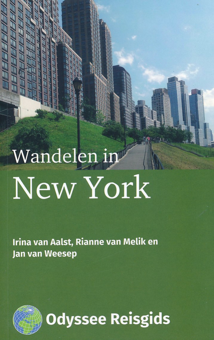
<p> Deze wandelgids laat je kennismaken met het New York achter de beroemde skyline. De zeventien wandelingen leiden je door interessante buurten van deze enerverende stad. Ze vertellen het verhaal over de ontwikkeling van New York: van een Nederlandse kolonie tot een palet van zeer verschillende buurten met een zeer gevarieerde bevolking.</p> <p> De wandelingen leiden je langs fantastische gebouwen en door bijzondere buurten in Manhattan, Brooklyn, Queens, de Bronx, en Staten Island. Maar de beschrijvingen gaan niet alleen over stenen. Het is de voortdurende instroom van nieuwe groepen, de talrijke bewonersinitiatieven en de reactie van het stadsbestuur daarop, die New York hebben vormgegeven. Dat maakt dat deze stad telkens opnieuw ontdekt kan worden. Iedere wandeling heeft een gedetailleerde beschrijving en een kaart van de route. </p> <p> En voor de afwisseling is er ook nog een fietstocht rondom Manhattan in deze gids opgenomen. Gewapend met het achterliggende verhaal worden deze routes een feest van verrassing én herkenning.</p> <ul> <li> Gedetailleerde routebeschrijvingen én boeiende achtergrondinformatie</li> <li> 2 overzichtskaarten, 17 wandelkaarten en 1 fietskaart</li> <li> 75 foto’s</li> <li> Tips voor horeca onderweg</li> <li> Bereikbaarheid van start en finish per openbaar vervoer</li> </ul>
€24,50
Bekijk product