
Beantwoord enkele vragen, en binnen seconden geeft AI je een persoonlijk aankoopadvies op maat.
Beantwoord enkele vragen, en binnen seconden geeft AI je een persoonlijk aankoopadvies op maat.
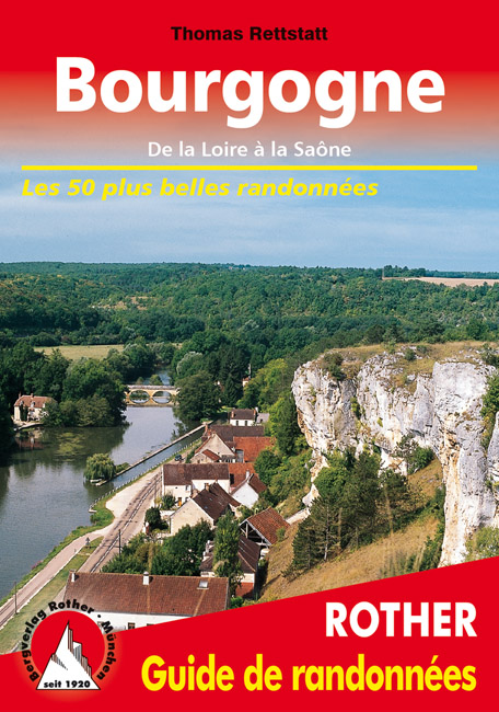
<p> Uitstekende wandelgids met een groot aantal dagtochten in dal en hooggebergte. Met praktische informatie en beperkt kaartmateriaal! Wandelingen in verschillende zwaarte weergegeven in rood/blauw/zwart.</p> <ul> <li> cartes de randonnée détaillées</li> <li> profils d’altitude informatifs</li> <li> traces GPS à télécharger</li> </ul> <div> La Bourgogne est célèbre pour l'excellence de ses vins, sa gastronomie et ses nombreux monuments historiques et religieux. Mais aller y faire de la randonnée ? Peu nombreux sont ceux qui y pensent, - bien à tort. Le paysage y est très varié, et on est souvent seul sur les chemins.</div> <div> Le guide de randonnée Rother « Bourgogne » se concentre sur le parc naturel du Morvan. Une jolie région aux collines couvertes de forêts, avec une flore et une faune riches et de nombreux lacs enchanteurs. Le sommet le plus haut ne s’élève qu’à 901 mètres, mais il ne faut pas sous-estimer les dénivelés. Les formations rocheuses du Saussois et de Bouilland peuvent même procurer des sensations « alpines ». Dans le Nord, on trouve également un paysage de collines avec des prés, des pâturages et des forêts. À l'Ouest, les randonnées traversent les vallées de deux fleuves encore sauplateau de Saône et dans les paysages marécageux de la Bresse avec ses nombreux étangs. Enfin, au sud, les chemins passent par des collines douces et des pâturages luxuriants où paissent les célèbres bœufs charolais. De nombreux canaux sillonnent la région et invitent à flâner tranquillement sur leurs rives.</div> <div> La Bourgogne est une région idéale pour tous ceux qui aiment associer randonnée et culture aux plaisirs de la table, et le guide de randonnée Rother vous sera un compagnon fiable. Les descriptions détaillées des itinéraires sont complétées par de nombreuses indications sur l'histoire et des informations sur les plus belles excursions. Les itinéraires sont faciles à suivre en toute sécurité grâce à des extraits de carte détaillés avec indication de l'itinéraire ainsi que des profils altimétriques appropriés. Le niveau de difficulté représenté par des couleurs facilite le choix des itinéraires.</div>
€17,50
Bekijk product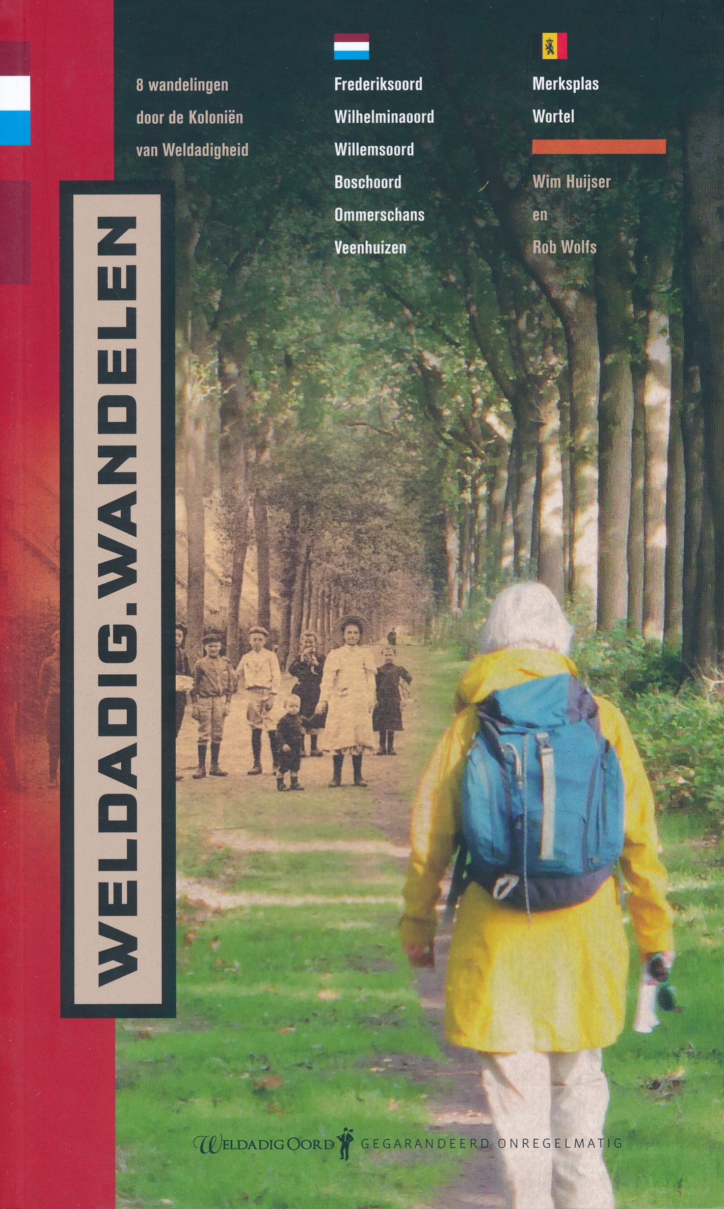
<div> Met deze wandelgids maken routemaker Rob Wolfs en publicist Wim Huijser de wandelaar deelgenoot van de strijd tegen de armoede die Johannes van den Bosch begin negentiende eeuw met de oprichting van de Koloniën van Weldadigheid voor ogen had. Het leed van de paupers, de armoedzaaiers die vanuit de steden tewerkgesteld werden op de schrale grond, echoot nog over de Drentse, Friese en Belgisch Kempense velden.We zwerven met deze gids langs gestichten, koloniehuisjes en -kerkjes door prachtige bomenlanen en langs vaarten waarin het zweet van de kolonisten nog maar nauwelijks is opgelost.</div> <div> </div> <div> In 2017 werden de Koloniën van Weldadigheid vanwege hun unieke cultuurhistorische waarde door de Nederlandse regering voorgedragen voor plaatsing op de Werelderfgoedlijst van Unesco. In de zomer van 2020 wordt definitief besloten of deze nominatie wordt toegekend. Ondertussen zijn de Koloniën ook voorgedragen bij de Europese Commissie voor de titel Europees Erfgoedlabel. Na het maken van deze wandelgids moet de toekenning daarvan volgens de auteurs nog slechts een formaliteit zijn</div>
€17,95
Bekijk product
<p> De Rother wandelgidsen beschrijven zeer goed de wandelingen in specifieke gebieden. In de gids vindt men kaarten, routebeschrijvingen en de nodige praktische informatie om van de wandelingen/trekkings een geslaagde onderneming te maken.</p> <div> Keine alltägliche Wanderregion: Das geschichtsträchtige einstige Land der Vögte liegt im Herzen Europas um das Vierländereck Sachsen, Thüringen, Bayern und Böhmen. Entsprechend vielfältig sind Leute, Kultur und Landschaft. Talsperren, Seenlandschaften, Flusstäler, Schaubergwerke, Brücken, Kirchen, Schlösser, Herrenhäuser und Museen machen den Reiz dieser einzigartigen Wandergegend aus – jede einzelne Tour hat ihre Besonderheiten. Und es lohnt sich, diese auszukosten. Wer Ruhe und eine entspannte Atmosphäre sucht, Natur spüren und erleben möchte, der ist im Vogtland genau richtig!</div> <div> </div> <div> 50 lohnende Unternehmungen hat der Autor Klaus Kaufmann im Rother Wanderführer Vogtland zusammengestellt. Sorgfältig recherchierte Wanderstrecken, verlässliche Wegbeschreibungen, detaillierte Informationen zu Verkehrsanbindung und Anforderungen sowie aussagekräftige Höhenprofile und detaillierte Kartenausschnitte machen alle Tourenvorschläge leicht und sicher nachvollziehbar. Ergänzend stehen GPS-Daten zum Download bereit. Zahlreiche Fotos stimmen auf ein erlebnisreiches Wandern ein.</div>
€19,50
Bekijk product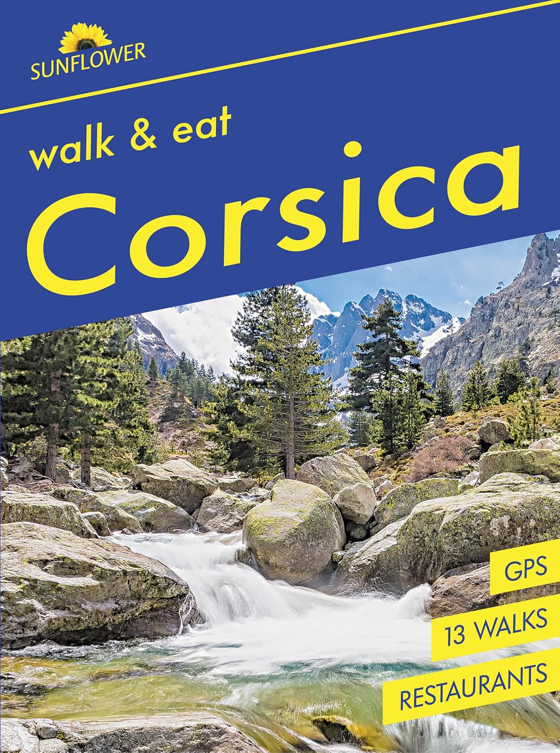
<div> Pocket-sized, full-colour guide to Corsica. Ideal for an active short break. Corsica Sunflower Walk and Eat pocket guide is designed to add another dimension to your walking holiday.</div> <div> </div> <div> It’s ideal if you want an easy stroll or a longer walk and is also suitable if you just want recommendations for things to do in Corsica and restaurants in Corsica. In Corsica Sunflower Walk and Eat guide you’ll find:Detailed, easy-to-follow descriptions of fairly straightforward walks with large-scale mapsExcursion on the world-famous Trinichellu, Corsica's narrow-gauge railwayRecommended restaurants en route serving local dishes with sample menus includedEssential holiday information including planning your trip, logistics on arrival, local markets and specialities, glossary of local food terms and a restaurant mini-vocabularyAdvice on natural local foods suitable for those with food intolerancesStreet maps of Ajaccio and BastiaAdditional recommendations included - information on Corsican wines and locally produced foodWhether you fly out for a weekend, week or a fortnight, with this book you’ll have in your hand enough walks, excursions, restaurants and recipes to last throughout - so you can choose the most appealing. For each suggested restaurant there is a photograph of the décor and one of their dishes, plus sample menu, price guide, opening times and a recipe for one of their specialities.</div> <div> </div> <div> All recipes have been tried, tested and enjoyed by the authors so we think you’ll enjoy them too!?‘Excellent! Just as described!‘ Bookworm</div>
€16,95
Bekijk product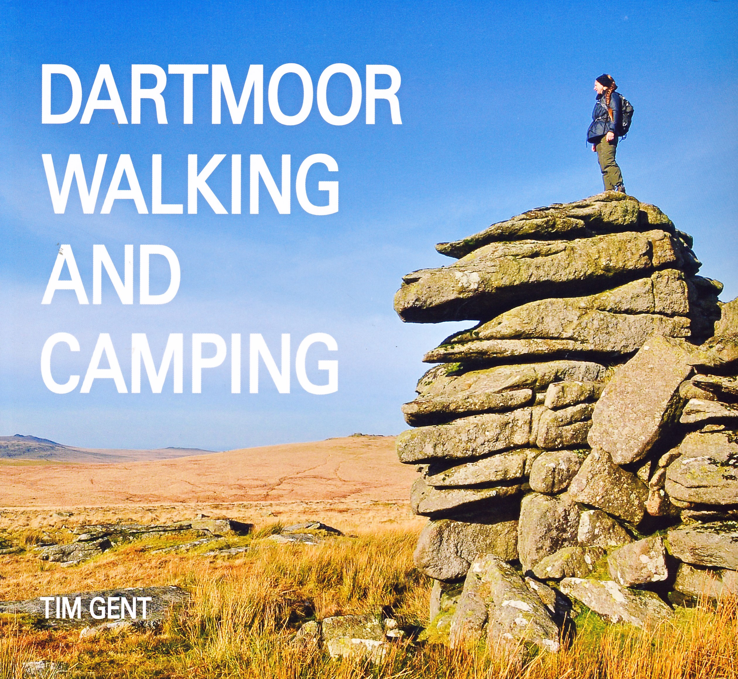
<div> Dartmoor hovers at the edge of almost every Devon view, drawing the gaze up towards those high tor-encrusted open spaces. The pull is strong, and Tim Gent’s book is written for all walkers answering the call.</div> <div> Introducing Dartmoor, its geology, archaeology, weather, flora and fauna, this book offers advice on when and how to visit, clothing to wear, kit to take and guidance on safe travel.</div> <div> </div> <div> Setting out onto the moor itself, thirty routes are included, ranging in length from 4km to over 80km. Multi-day journeys make the most of permitted wild camping opportunities, and Tim’s book also considers the gear and decisions needed to make the most of these overnight stays.</div>
€27,95
Bekijk product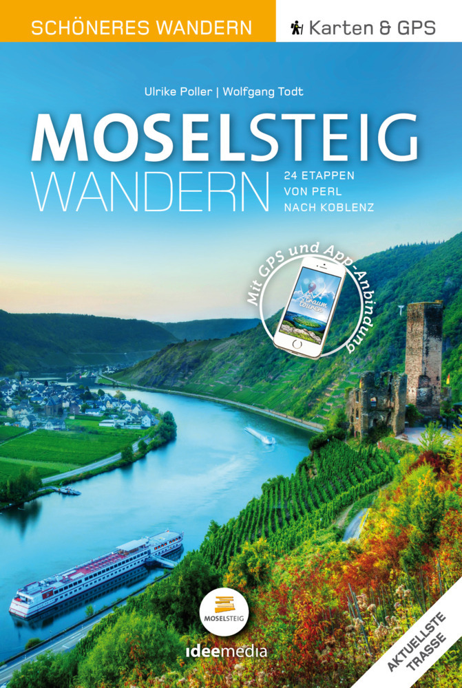
<div> Schöne Schleifen, sagenhafte Ausblicke, Kunst, Kultur und Küche: Der neue Moselsteig verbindet auf seinen 365 Kilometern von Perl nach Koblenz sportliche Herausforderung mit viel Genuss für alle Sinne. Die Wanderexperten Ulrike Poller und Wolfgang Todt, Autoren des umfangreichen offiziellen Wanderführers zum Moselsteig und Insider der Strecke, stellen in diesem praktischen Pocket-Führer alle 24 Etappen in Kompaktform und mit der aktuellen Trasse 2021 vor. Übersichtliche Infoteile, Detailkarten und Höhenprofile enthalten alle wesentlichen Fakten, ausgewählte Tipps führen zu Sehenswürdigkeiten, Einkehr- und Übernachtungsmöglichkeiten. Mit der geschützten Internet-Anbindung "Scan to go" können sich Smartphone-Besitzer zu den Ausgangspunkten der Einzeletappen führen lassen, aktuelle GPS-Daten und die einfache Direktanbindung per QR-Code an die Gratis-App "traumtouren" weisen - neben rund 20 000 Hinweisschildern auf der Strecke - immer den richtigen Weg.</div> <div> </div> <div> Schöne Schleifen, sagenhafte Ausblicke, Kunst, Kultur und Küche: Der neue Moselsteig verbindet auf seinen 365 Kilometern von Perl nach Koblenz sportliche Herausforderung mit viel Genuss für alle Sinne. Die Wanderexperten Ulrike Poller und Wolfgang Todt, Autoren des umfangreichen offiziellen Wanderführers zum Moselsteig und Insider der Strecke, stellen in diesem praktischen Pocket-Führer alle 24 Etappen in Kompaktform und mit der aktuellen Trassenführung 2021 vor.</div>
€14,95
Bekijk product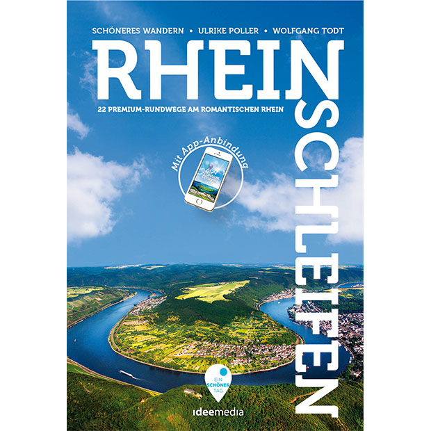
<p> Handzame wandelgids mer 21 rondwandelingen in het Rijngebied.</p> <div> Ob Baumgeistertour oder Fürstenweg: Zwischen 5 und 20 Kilometern winden sich die Rheinschleifen durch malerische Seitentäler, stille Wälder und wogende Wiesen zu atemberaubenden wie einmaligen Ausblicken. Ulrike Poller und Wolfgang Todt beschreiben die Routen der neuen Premium-Rundwanderwege, die Höhepunkte und geben wertvolle Tipps zu den besten Abstechern und Laufrichtungen.</div> <div> </div> <div> Die geschützte Online-Anbindung Scan-to-go® ermöglicht die direkte Anzeige der Ausgangspunkte über das Abscannen der QR-Codes. Aktuelle Präzisions-GPS-Daten stehen im gängigen .gpx-Format zum Download zur Verfügung. Ebenfalls können die enthaltenen QR-Codes mit der App „traumtouren“ verwendet werden, was die Orientierung unterwegs noch einfacher macht: Einfach QR-Code mit der geöffneten „traumtouren“-App abscannen – und immer wissen, ob man auf dem richtigen Pfad ist.</div>
€15,50
Bekijk product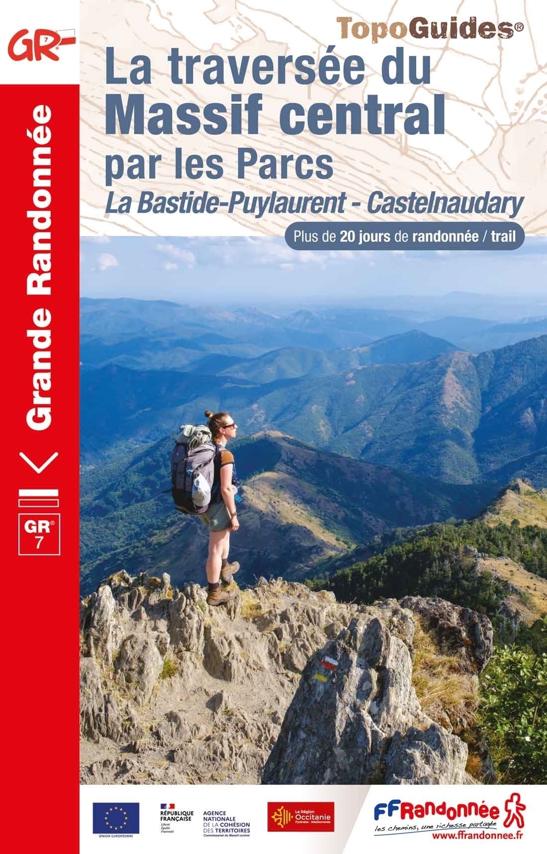
<p> Franstalige wandelgids met een beschrijving van een aantal dagtochten / rondwandelingen. Uitstekende beschrijvingen met duidelijk kaartmateriaal. Mislopen is nauwelijks mogelijk, maar ja .. de franse taal! Ook praktische informatie staat in deze gids. Alle gidsen bevatten een door ons toegevoegde uitgebreide frans - nederlandse wandelwoordenlijst.</p> <p> Traversez les parcs naturels du Massif central. Plus de 20 jours de randonnée sur la partie sud du GR® 7, de La Bastide-Puylaurent à Castelnaudary.</p> <div> Le massif central, vaste étendue montagnarde où le GR® 7 évolue sur près de 800 kilomètres.</div> <div> </div> <div> Ce topoguide présente la partie sud de la traversée de la Bastide-Puylaurent à Castelnaudary. Elle se distingue par des paysages naturels remarquables : les montagnes cévenoles, le canyon du cirque de Navacelles, les forêts de la Montagne noire ou encore les landes à bruyère des monts du Caroux.</div> <div> </div> <div> Il est possible de s’écarter légèrement de l’itinéraire pour accéder au sommet du Mont Lozère culminant à 1 699 mètres.</div> <div> </div> <div> Le GR® 7 convient aussi à la pratique du trail.</div>
€19,95
Bekijk product
<div> Explore the castles and coast of Northumberland from Dunstanburgh to Hadrian’s Wall with ten walks suitable for all ages and abilities. Discover England’s most northerly county from the North Sea coast to the North Pennines on hand-picked, leisurely rambles for the whole family.</div> <div> </div> <div> Northumberland Short Walks Made Easy include:</div> <div> </div> <div> - Circle dramatic Bamburgh Castle, looking out to the Farne Islands from wildlife-rich dunes, and see the grave of lifeboat heroine Grace Darling</div> <div> - Enjoy the tranquility of secluded Wooler Common with its wealth of wildlife and ancient remains on the edge of the Cheviots</div> <div> - Start at picturesque Craster and follow the coast path to Dunstanburgh Castle, a rugged ruin perched on a rocky, wave-battered headland</div> <div> - Ramble the shores of Kielder Water, spot nesting ospreys and stumble upon the fascinating artworks in the forest</div> <div> - Follow Hadrian’s Wall from Cawfields near Haltwhistle to see the iconic Roman structure close up, with stunning views in both directions</div> <div> - Stroll along the banks of the River Tyne and see Hexham’s medieval abbey</div> <div> - Climb Shaftoe Crags for far-reaching views of central Northumberland</div> <div> </div> <div> OS Pathfinder Guides: Short Walks Made Easy:</div> <div> </div> <div> - 10 accessible walks suitable for the whole family</div> <div> - All routes are between 2 to 5 miles and can be completed all year round</div> <div> - Know what to expect before you go: Information on locations of cafes/pubs and toilets, terrain, hilliness and accessibility for pushchairs and wheelchairs</div> <div> - Large-scale Ordnance Survey maps for ultra-easy navigation and route-finding, featuring intuitive pictorial symbols</div> <div> - Numbered points which tie maps to route descriptions and walk profiles</div> <div> - Route photographs for each numbered point so you know exactly where you’re going</div> <div> - Discover GPS waypoints, parking information and detailed route descriptions for foolproof navigation</div> <div> - Enhance your adventure with stories behind each walk and nature notes</div> <div> - Get active outside and enjoy the physical and mental health benefits</div> <div> </div>
€10,95
Bekijk product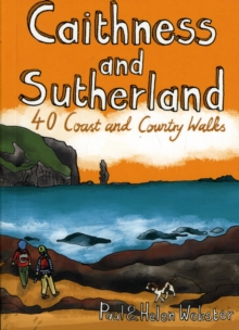
<div> <p> <span style="color: rgb(0, 0, 0); font-family: "Helvetica Neue", Helvetica, sans-serif, Arial;">Handige compacte wandelgids met 40 dagwandelingen. Deze gids bevat kleine kaartjes en leuke uitgebreide informatie over wat er langs de route te zien is. Goede wandelkaarten zijn echter we noodzakelijk voor deze tochten: de Ordnance Survey explorer maps of Landanger maps zijn zeer geschikt.</span></p> <p> The county of Ayrshire is located on the Firth of Clyde on the beautiful West Coast of Scotland and is known as one of the most fertile areas of the country, famed for its cattle and crops. Although more industrial to the north, it is in the main a landscape made for walking with an abundance of open countryside and rugged little hills, golden sandy beaches and beautiful sunsets. This guide features 40 mostly moderate walks full of interest which explore all aspects of the region, from craggy cliffs and caves to historic castles, ancient forests to sandy shorelines.</p> </div> <div> Sutherland and Caithness are the most northerly parts of mainland Britain. Northwest Sutherland is a landscape of sandy beaches and sweeping moorland studded with glittering lochans, overlooked by some of Scotland's most remarkable mountains, individual peaks each with great character. This guide features 40 of the best walks in this popular area.</div>
€10,95
Bekijk product