
Beantwoord enkele vragen, en binnen seconden geeft AI je een persoonlijk aankoopadvies op maat.
Beantwoord enkele vragen, en binnen seconden geeft AI je een persoonlijk aankoopadvies op maat.

<div> Die nationale Route 1 Via Alpina ist Teil des gleichnamigen Fernwanderwegnetzes. Fünf Fernwanderwege durchqueren von Triest bis Monaco acht Alpenstaaten. Auf dem Gebiet der Schweiz führt die nationale Route 1 Via Alpina von Vaduz über zahlreiche Alpenpässe bis zum Trüttlisbergpass, in der Nähe von Lenk, und von dort entweder auf der internationalen Route Richtung Monaco weiter bis zum Grossen Sankt Bernhard oder auf dem nationalen Zubringer der Via Alpina in vier Etappen bis nach Montreux.</div> <div> </div> <div> In 19 Etappen 370 Kilometer atemberaubende alpine Bergwelt und eine reiche Vielfalt unterschiedlicher Lebens-, Kultur- und Naturräume erleben. Mit allen praktischen Informationen, übersichtlichen Kartenausschnitten und Höhenprofilen, einer Fülle an Hinweisen auf Sehenswürdigkeiten und Attraktionen am Weg sowie mit Farbfotos reich illustriert.</div> <div> </div> <div> <ul> <li> Die offiziellen Routenführer in aktualisierter Neuausgabe.</li> <li> In 19 Etappen 370 Kilometer atemberaubende alpine Bergwelt und eine reiche Vielfalt unterschiedlicher Lebens-, Kultur- und Naturräume erleben.</li> <li> Mit allen wichtigen Informationen, Kartenausschnitten und Höhenprofilen, einer Fülle an Hinweisen auf Sehenswürdigkeiten und Attraktionen am Weg.</li> </ul> </div> <p> </p>
€27,50
Bekijk product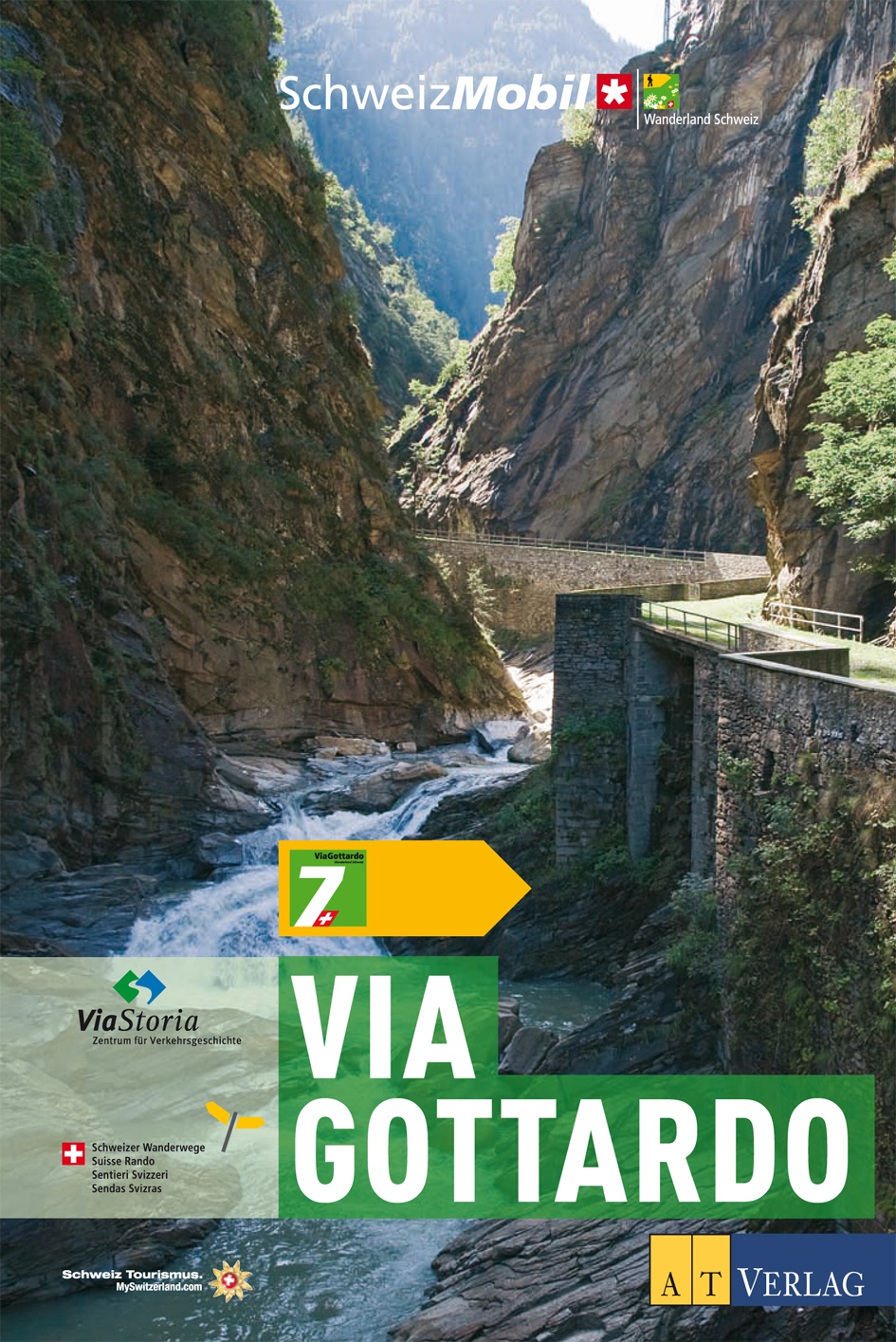
<p> Die nationalen Wanderland Routen 7 und 77 ViaGottardo folgen den frühen Alpenquerern auf ihrem Weg in den Süden. Seit dem Mittelalter nutzten Kaufleute und Händler die Gotthard-Route, um von Nordeuropa in den Süden zu kommen und umgekehrt. Ihre Reise begann in der Hafenstadt Basel (Route 7) oder Schaffhausen (Route 77) und setzte sich fort durchs Mittelland und über die Seen der Zentralschweiz. Von hier führt nur noch ein Weg über die Alpen (Wanderland Route 7). Der Gotthardpass ist auch heute noch das Herzstück der Reise. Die Wandernden begegnen auf der ViaGottardo immer wieder Zeugen einer Jahrhunderte alten Weggeschichte, alten Landstrassen und Saumwegen, Zollhäusern und Wegkapellen, Schiffsländen und Bollwerken. Die ViaGottardo überrascht auf ihren 27 Tagesetappen aber auch mit Einblicken in eine sehr moderne Schweiz.</p> <ul> <li> Der offizielle Führer zur neuen Wanderland-Route 7 via Gottardo.</li> <li> In 27 Etappen von Basel oder Schaffhausen über den Gotthard ins Tessin.</li> <li> Mit Texten, Kartenausschnitten und allen praktischen Angaben.</li> </ul>
€35,50
Bekijk product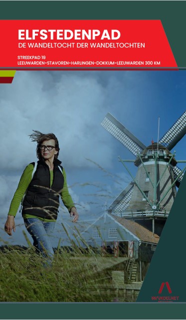
<p> Routegids met gedetailleerde topografische kaarten waar de route duidelijk op ingetekend is. Daarnaast alle noodzakelijke informatie als openbaar vervoer, geen overnachtingsadressen!</p> <p> Gebruikmakend van voormalige jaagpaden en kerkenpaden, van eeuwenoude grasdijken, van veelbetreden handelswegen, zijn routemakers Johan Vellinga en Broer Adema erin geslaagd de Friese steden op een voor wandelaars zo aantrekkelijk mogelijke manier aan elkaar te rijgen. Het Elfstedenwandelpad is met 283 kilometer een stuk langer dan de andere Elfstedentochten. Daar is een goede reden voor. Volgen schaatsers en ook wandelsporters over het algemeen de kortste weg, deze wandelroute zoekt de mooiste paden uit. Meer nog dan om de steden, gaat het om het tussenliggende land en om de paden die de steden verbinden. De schoonheid van de Greidhoeke en het Merengebied staat buiten kijf, maar Friesland is meer dan weiland en water. Het Elfstedenpad maakt een royale slag door de heuvels en bossen van het Gaasterland. Voorbij Dokkum doorkruist het de typische houtwallen in het coulissenlandschap van de Fryske Wâlden. Met het Elfstedenpad is een prachtig stukje Friesland niet alleen voor schaatsers, fietsers en watersporters, maar nu ook voor wandelaars ontsloten is.</p>
€19,95
Bekijk product
<p> Uitstekende wandelgids, goed beschreven met veel praktische informatie om de route te kunnen lopen, inclusief redelijke kaarten</p> <div> There's far more to Cyprus than just the bustling resorts: the favourable climate, attractive scenery and many kilometres of footpaths and nature trails make it an ideal destination for walkers. This guidebook presents 44 graded walks spread across the island, covering both southern and northern Cyprus, with a slight focus on the central Troodos region. Clear description and mapping is presented for each route and a route summary table makes it easy to choose an appropriate walk.</div> <div> </div> <div> The walks, of 3 to 20km, range from gentle strolls to longer, more demanding routes, sometimes involving steep ascents, difficult terrain or navigational challenge. They showcase Cyprus's captivating landscapes, from the sun-kissed coastline lapped by clear turquoise waters to the pine-clad slopes of the Troodos and Besparmak Mountains. Many visit sites of historical interest – including UNESCO-listed Byzantine monasteries, Venetian bridges, defensive castles and hideouts from the 1950s independence struggle – and other highlights include the stunning Avakas Gorge, the caves of Cape Greco and the striking Besparmak range.</div> <div> </div> <div> As well as the walks, the guide offers plenty of information to help you organise and get the most out of your trip, with advice on transport, bases and border crossings. There is a summary of the island's fascinating and turbulent history and an overview of its plants and wildlife. Blending information with inspiration, 'Walking in Cyprus' contains all you need to discover a hidden side to this Mediterranean gem.</div> <div> </div> <div> Steden en Dorpen</div> <div> Paphos, Polis, Troodos Square, Platres, Kakopetria, Kyrenia/Girne, Lapta, Alevkaya</div>
€23,95
Bekijk product
<p> Kleine wandelgids van een deelgiebied in het zuiden van Albanië. Routes zijn redelijk beschreven en de kaarten die er bij gevoegd zijn, zijn ook van redelijk nivo. </p> <p> </p> <p> </p>
€10,50
Bekijk product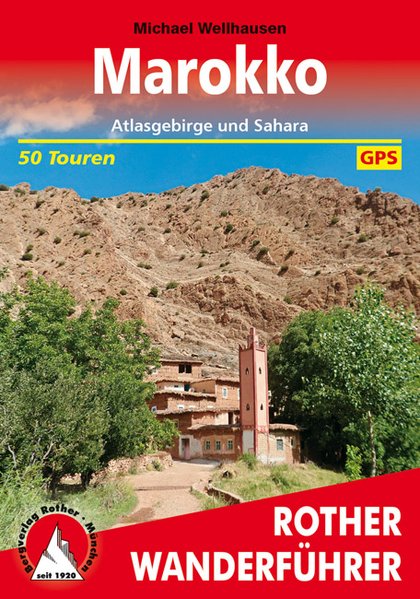
<p> Uitstekende wandelgids met een groot aantal dagtochten in dal en hooggebergte. Met praktische informatie en beperkt kaartmateriaal! Wandelingen in verschillende zwaarte weergegeven in rood/blauw/zwart.</p> <p> 50 Höhenprofile, 50 Wanderkärtchen im Maßstab 1:50.000 / 1:100.000, eine Übersichtskarte, GPS-Tracks zum Download</p> <div> Nur wenige Seemeilen von Europa entfernt und doch eine völlig andere Welt: Der »Zauber des Orients« beginnt in Marokko, dem Land, wo Atlantik und Mittelmeer zusammentreffen. Das Königreich verzaubert nicht nur mit exotischen Düften, mit Städten und Dörfern wie aus tausendundeiner Nacht, sondern auch mit spektakulärer Natur und einem ungeahnten Spektrum an Wandermöglichkeiten zwischen Küste und Hochgebirge. Der Rother Wanderführer »Marokko« präsentiert 52 abwechslungsreiche Touren - von spannenden Halbtageswanderungen bis zu mehrtägigen Unternehmungen in unberührten Landschaften.Wer den Nervenkitzel in hochalpinem Gelände sucht, wird ebenso fündig wie Genusswanderer, für die das Kulturerlebnis und die Schönheit der Natur im Vordergrund stehen. Das mediterran geprägte, wild zerklüftete Rifgebirge und der karstiger Fels im Mittleren Atlas begeistern Besucher aller Art. Gewaltig, aber relativ leicht ersteigbar sind die Viertausender des Hohen Atlas. Gemütliche Wanderungen führen in den Antiatlas mit seinen malerischen Siedlungen aus Lehmhäusern. Und in der Sahara im Süden des Landes lassen sich herrliche Wanderungen durch Dünenlandschaften und zu Oasen mit Palmenhainen unternehmen. Für die wohlverdiente abendliche Erholung sorgen schließlich gemütliche Unterkünfte und die marokkanische Küche mit Couscous und Pfefferminztee.Der Autor Michael Wellhausen ist ebenso ambitionierter wie weitgereister Bergwanderer. Seine Afrika- und Sahara-Erfahrungen fließen in die Texte ein, die neben exakten Tourenbeschreibungen auch viel Wissenswertes zu Land und Leuten bieten. Detaillierte Angaben zu Verkehrsanbindung, Einkehr und Unterkunft, dazu Wanderkärtchen mit eingezeichnetem Routenverlauf, aussagekräftige Höhenprofile und GPS-Daten zum Download machen die Planung und Durchführung der Wanderungen unkompliziert. Die zahlreichen Fotos lassen schon zuhause »orientalische« Urlaubsstimmung aufkommen.</div>
€20,50
Bekijk product
<div> Route / Traject: GR5 Ardennen van Maastricht tot Ouren, totaal 162 km</div> <div> </div> <div> Zowaar: prachtige en duidelijke Nederlandstalige gidsjes van telkens een traject van 1 tot 2 weken. De boekjes beschikken over weliswaar schetsmatige maar gedetailleerde kaarten in kleur met ingetekende GR5-route, hoogteprofielen, en een Nederlandstalige routebeschrijving. Er is geen informatie over de omgeving opgenomen. Als je buiten de route van de GR5 gaat, dan is dit boekje niet voldoende. </div> <div> </div> <div> Absoluut een aanrader voor wie niet met de Franse taal overweg kan; ook als aanvulling op de Franse gidsen kan het nuttig zijn. </div> <div> </div> <div> GR-5 GR5 GR5/E2</div> <div> </div>
€19,50
Bekijk product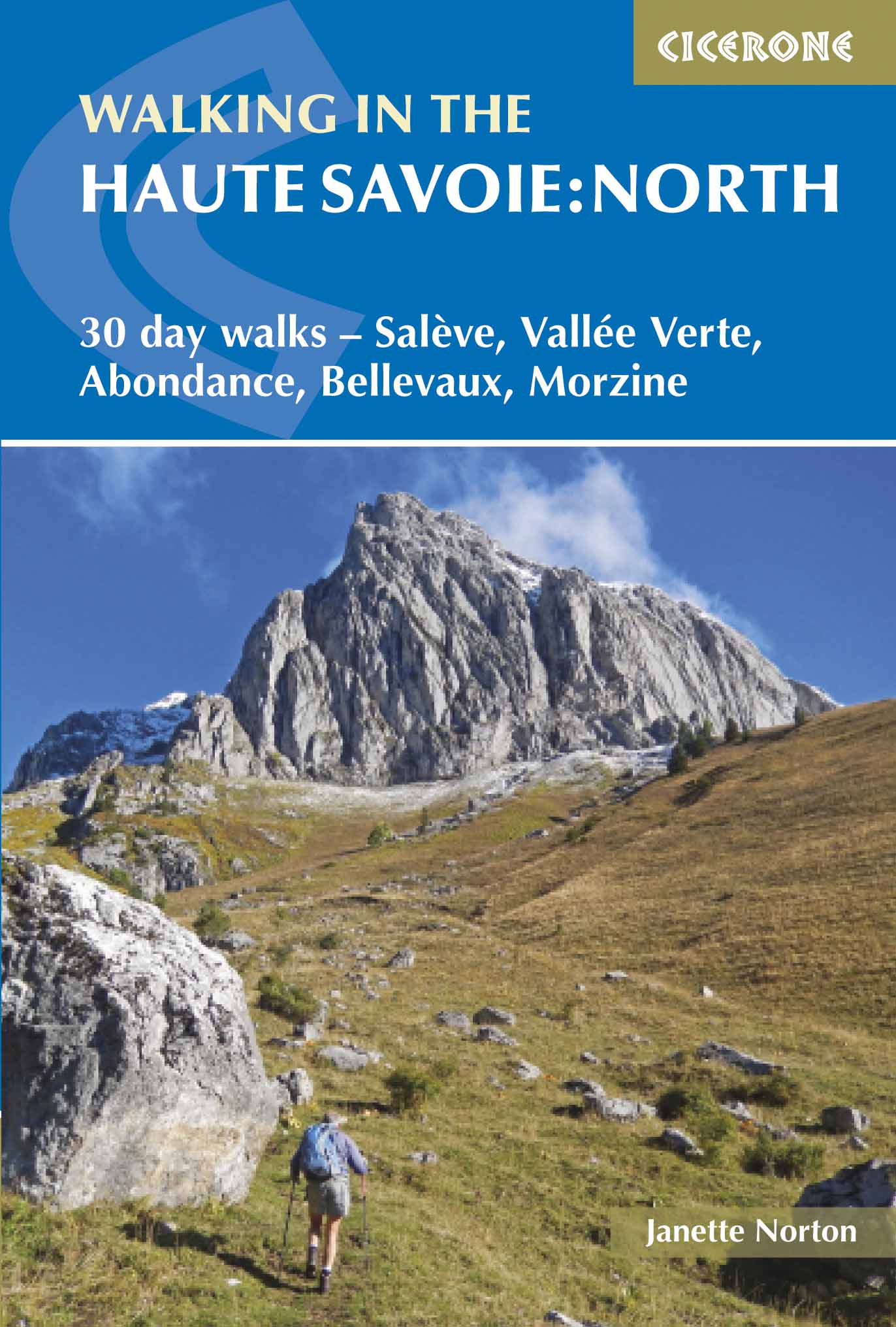
<p> Uitstekende wandelgids van dit geweldige gebied. Goed beschreven met veel praktische informatie om de route te kunnen lopen, inclusief redelijke kaarten.</p> <div> A guidebook of half and full-day walks in the lovely Haute Savoie mountains of France. This guide describes 30 circular routes of between 7 and 13km, based around Evian-les-Bains, Morzine, Abondance, Châtel, St-Julien-en-Genevois, Bellevaux, Boège and Habère-Poche. Graded from easy to difficult, there are walks to suit most abilities, but a few have some exposed sections and need a head for heights.</div> <div> </div> <div> The guide is divided into 6 areas covering the Salève and Vuache, the Vallée Verte, the Vallée du Brevon, Pre-Alpes du Léman and Val d'Abondance. Alongside a detailed route description and map, each walk has a summary of all you need to know before you set out (distance, time to walk, ascent, maximum altitude and instructions for accessing the start). The guidebook includes advice on travel, accommodation and equipment, as well as information about local wildlife and Savoyard food and drink, and a glossary of useful French words.</div> <div> </div> <div> Visitors flock to the Chamonix area and the Mont Blanc range, but that is only part of what the Haute Savoie has to offer. With highlights including Cornettes de Bise, Mont de Grange, Dent d-Oche and Pic Boré, the walks in this guide will show you a quieter, less busy side to this outstandingly beautiful area.</div> <div> </div> <div> <strong>Dorpen en Steden</strong></div> <div> Evian-les-Bains, Morzine, Abondance, Châtel, St-Julien-en-Genevois, Bellevaux, Boège, Habère-Poche</div> <p> </p>
€20,95
Bekijk product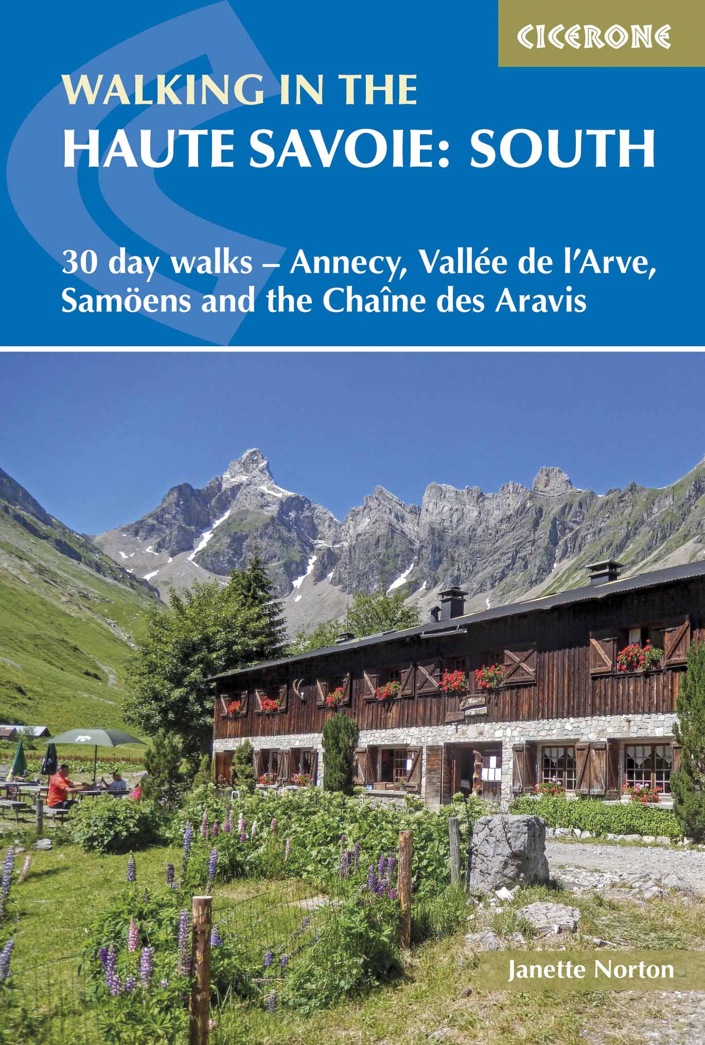
<div> Uitstekende wandelgids van dit geweldige gebied. goed beschreven met veel praktische informatie om de route te kunnen lopen, inclusief redelijke kaarten.</div> <div> </div> <div> A guidebook of walks in the lovely Haute Savoie mountains of France. This guide describes 30 circular routes of between 7 and 20km, based around Annecy, La Clusaz, Grand Bornand, Plateau d'Assy, Samoëns, Sixt, Sallanches, Thônes, la Roche-sur-Foron. Graded from easy to difficult, there are walks to suit most abilities, but a few have some exposed sections and need a head for heights.</div> <div> </div> <div> The guidebook is divided into 6 areas covering the Arve Valley, the Haut Giffre valley, the Chaîne des Aravis (north and south), Plateau de la Borne and Lake Annecy. Alongside a detailed route description and map, each walk has a summary of all you need to know before you set out (distance, time to walk, ascent, maximum altitude, grade and instructions for accessing the start). There is advice on travel, accommodation and equipment, as well as information about local wildlife and Savoyard food and drink, and a glossary of useful French words.</div> <div> </div> <div> Visitors flock to the Chamonix area and the Mont Blanc range, but that is only part of what the Haute Savoie has to offer. With stunning views of high mountains as well as lower peaks to enjoy, the walks in this guide will show you a quieter, less busy side to this outstandingly beautiful area.</div> <div> </div> <div> Dorpen en steden</div> <div> Annecy, La Clusaz, Grand Bornand, Plateau d'Assy, Samoëns, Sixt, Sallanches, Thônes, la Roche-sur-Foron</div>
€20,95
Bekijk product
<p> Uitstekende wandelgids van een gerenommeerde Engelse uitgever. De tochten zijn met zorg beschreven en voorzien van allerhande nuttige informatie.</p> <p> With its white sandy beaches, pine forests, snow-capped peaks, traditional villages, lush river valleys and olive groves, the GR7 in Andalucía takes you on a journey through the most geographically diverse region on the Iberian peninsula.</p> <p> This wonderfully varied route starts at the southernmost tip of Spain at Tarifa, and meanders through the provinces of Cádiz and Málaga before dividing. The northern route heads through Córdoba and Jaén provinces (711km in total), whilst the southern route passes through Almería and Granada (720km). The route crosses seven stunning natural parks and the Sierra Nevada national park.</p> <p> • The first guide to cover the whole of the GR7 in Andalucía.<br /> • Detailed route description for around 60 days of walking, with options for creating shorter sections and days.<br /> • Information on all the villages en route offering accommodation so that you can plan your own route.</p> <div> The GR7 is one of Europe's longest GR long-distance routes, stretching from Tarifa, the southernmost town of continental Europe, through Spain, Andorra and France to Alsace. This guide presents the Andalucian section of the route, which offers well over 700km of fantastic walking through the diverse landscapes of one of Spain's most evocative regions. The route splits at the small village of Villanueva de Cauche, and the guide describes both the northern and southern variants. Although walking is on good footpaths, country tracks and, occasionally, minor roads, some of the stages are long and can involve considerable ascent, meaning that a good level of fitness is required. The full Andalucian GR7 takes well over a month to walk; however, the guide also includes suggestions for highlight sections that can be walked in a week or fortnight.</div> <div> </div> <div> In addition to clear route description, mapping and elevation profiles, the guide provides background information on local history, plants and wildlife, and advice for planning your trip, such as when to go, what to take and where to stay.</div> <div> </div> <div> The route showcases Andalucia's rich history and culture and varied landscapes, which include pine forests, semi-arid desert, snow-capped peaks, fertile plains, lush valleys, olive groves, cultivated terraces and hills of cork woodland. Historic towns and traditional whitewashed villages offer overnight accommodation and a chance to sample local cuisine.</div>
€26,50
Bekijk product