
Beantwoord enkele vragen, en binnen seconden geeft AI je een persoonlijk aankoopadvies op maat.
Beantwoord enkele vragen, en binnen seconden geeft AI je een persoonlijk aankoopadvies op maat.
<p> Wandelgids - duitstalig - Haddangervidda - ook geschikt voor skitouren - wandelen Noorwegen: goede en informatieve tekst, per etappe beschreven, kaartmateriaal wat beperkt.</p> <div> Fast 1.200 km markierte Wanderwege in einer beeindruckenden Landschaft und ein dichtes Hüttennetz laden zu Touren in der Hochebene Hardangervidda in Südnorwegen ein. Der Wanderführer stellt zwei besonders empfehlenswerte Wanderrouten (Nord-Süd- und Ost-West-Querung) und eine Radtour auf dem bekannten Rallarvegen vor. </div> <div> </div> <div> Jeder Weg wird in mehreren Etappen detailliert beschrieben, zudem gibt es Empfehlungen für Abstecher und Varianten. Genaue Angaben zu Etappenlänge, Zeitbedarf und Übernachtungsmöglichkeiten sowie Kartenskizzen und Höhenprofile erleichtern die Planung. Ein ausführliches Kapitel mit allgemeinen Reise-Infos hilft Ihnen bei der Vorbereitung der Reise, ein landeskundlicher Teil bringt die Besonderheiten der Region näher.</div>
€17,50
Bekijk product
<p> Wandelgids van een deel van Engeland, Schotland of Wales. Deze gids bevat 28 dagwandelingen, variërend van korte tochten tot pittige dagtochten. De bijbehorende kaarten zijn uitstekend: men heeft de topografische kaarten van Ordnance Survey gebruikt waarop de route is ingetekend. Daarnaast praktische informatie over de wandeling en wat beschrijvingen van het gebied.</p> <p> Each of the Jarrold Pathfinder titles features 28 circular routes, all tried and tested by seasoned walkers. The routes range from extended strolls to exhilarating hikes, so there is something for everyone.</p> <p> They also contain:</p> <p> -Ordnance Survey mapping;<br /> -background details of each area;<br /> -details of refreshment stops and parking;<br /> -walking safety advice; and<br /> -information about walkers and the law</p> <p> </p>
€18,50
Bekijk product
<p> Wandelgids van een deel van Engeland, Schotland of Wales. Deze gids bevat 28 dagwandelingen, variërend van korte tochten tot pittige dagtochten. De bijbehorende kaarten zijn uitstekend: men heeft de topografische kaarten van Ordnance Survey gebruikt waarop de route is ingetekend. Daarnaast praktische informatie over de wandeling en wat beschrijvingen van het gebied.</p> <p> Access 160 miles of breath-taking walking amid the stunning scenery of Loch Lomond National Park and Stirlingshire. This Pathfinder guide book offers 28 great walks varying from 2 to 16 miles complete wit Ordnance Survey mapping and GPS references.</p> <div> Walking in Scotland is quite different from walking south of the border. In England there are only eight summits that top 3000 ft, while in Scotland there are 277, with 45 of them situated in the Southern Highlands. The Trossachs are particularly spectacular when clothed in autumn colours and provided the setting for The Lady of the Lake and Rob Roy, by Sir Walter Scott.</div> <div> </div> <div> The Ochil Hills, Loch Lomond and the West Highland Way are also included, and there is an opportunity to see Stirling and the Wallace monument, overlooking the scene of the Scottish patriot's victory over Edward I.</div> <div> </div> <div> 28 circular, graded walks all tried and tested by seasoned walkers. The routes range from extended strolls to exhilarating hikes, so there is something for everyone.</div>
€18,50
Bekijk product
<p> Wandelgids van een deel van Engeland, Schotland of Wales. Deze gids bevat 28 dagwandelingen, variërend van korte tochten tot pittige dagtochten. De bijbehorende kaarten zijn uitstekend: men heeft de topografische kaarten van Ordnance Survey gebruikt waarop de route is ingetekend. Daarnaast praktische informatie over de wandeling en wat beschrijvingen van het gebied.</p> <p> This new edition of Pathfinder: Edinburgh, Pentlands & Lothians has been fully revised to include seven new walking routes, including a classic walk to the summit of Arthur's Seat. The countryside around Edinburgh is ideal for walking with rolling hills and an impressive Scottish coastline. Pathfinder: Edinburgh, Pentlands & Lothians includes new walks in the Pentlands Hills, the Moorfoot and the Lammermuir Hills, perfect for all ages and abilities, and all within 20 miles of Edinburgh; Scotland's historic capital city.</p> <p> With 28 stunning walking routes, ranging from 3-10 miles, Pathfinder walks are the essential walking guide, as well as including Ordnance Survey maps, GPS waypoint references and public transport information, they offer something for everyone. Pathfinder Guides are Britain's best loved walking guides. They are the perfect companion for country walks throughout Britain.</p> <p> Each title features 28 circular walks with easy-to-follow route descriptions, all tried and tested by seasoned walkers. The routes range from extended strolls to exhilarating hikes, so there is something for everyone.<br /> They also contain:</p> <p> -Ordnance Survey mapping;<br /> -background details of each area;<br /> -details of refreshment stops and parking;<br /> -walking safety advice; and<br /> -information about walkers and the law</p> <p> </p>
€18,50
Bekijk product
<p> Mooi uitgevoerde wandelgids in een handzaam formaat: 15 x 10 cm. De wandelingen zijn duidelijk beschreven, soms een beetje summier.</p> <p> This Pocket Mountains guide to the Southern Uplands of Scotland contains 40 hill walks, trademark photography and inventive circular routes. Each route is accompanied by a full colour photograph, contoured map and additional facts about the history, geology and wildlife. Coverage of The Galloway Hills, Lowther and Moffat Hills, Clyde and Tweed, Edinburgh and Lothian, Cheviot and Langholm Hills.</p> <p> </p>
€10,95
Bekijk product
<p> Deze gids een goede beschrijving van de lange afstands route. De kaarten zijn schetsmatig maar wel duidelijk.</p> <div> The Speyside Way is one of Scotland’s Great Trails. It runs for 80 miles (128 km) from the fishing port of Buckie to Aviemore in the foothills of the Cairngorms. Following the lovely valley of the River Spey, you walk through countryside rich in malt whisky and wildlife, along riverside paths, railway trackbed and forest and moorland tracks.</div> <div> </div> <div> The second edition was fully revised, with mapping from Footprint in six panels, updated plans of villages along the Way, including a fresh Grantown plan and directions from the terminus in Buckie. In 2016 we released the revised version of this essential trail guide, with fresh photos, new mapping and many other updates. These included documenting the 6.5-mile route extension to Kincraig, which opened in 2015, and 11-mile Badenoch Way.</div> <div> </div> <div> <div> This guidebook contains all you need to plan and enjoy the Speyside Way:</div> <div> </div> <ul> <li> the Way step-by-step, with summaries of distance, terrain and refreshments</li> <li> other walks including the Badenoch Way and Dufftown circuit</li> <li> habitats and wildlife, including dolphin, osprey and wildcat</li> <li> expanded coverage of whisky-making and distilleries</li> <li> planning information for travel by car, train, bus or plane</li> <li> in full colour, with 70 photographs</li> <li> drop-down map showing the Speyside Way, plus Tomintoul spur (1:100,000)</li> <li> rucksack-friendly and on rainproof paper.</li> </ul> </div> <p> </p>
€22,50
Bekijk product
<p> Uitstekende wandelgids, sommige meerdaags, voor dit uitdagende wandelgebied in Schotland.</p> <p> This third edition of Terry Marsh’s walking and scrambling guide to Skye, the Hebrides, northwest Scotland, updated using digital mapping and GPS. 87 walks and scrambles in Sleat and South-East Skye, Strath, Minginish, Duirinish, Waternish and Trotternish for all abilities. Each route describes local historical and geological points of interest.</p> <p> The fame of Skye, the most scenically awe-inspiring of Scotland's many islands, is widespread; you either love it, or hate it. There is no neutrality.</p> <p> For walkers and climbers this is the Promised Land, a place of raw elemental forces, a land barely scratched by man. Over-riding everything hangs an indefinable, almost supernatural, charisma that evokes a deep and abiding affection among those privileged to share Skye's secrets. To go in search of those secrets there is no better way than on foot, and in this collection of walks, Terry Marsh visits all corners of the island, not just the well-known haunts.</p> <p> This new edition, in full colour, continues the tradition of the first, by visiting all corners of the island, including the renowned Cuillin. Walks range from simple outings not far from civilisation to rugged, hard and demanding days, as tough as anything in Britain, often in isolated situations. The walks in this book will suit all tastes, and embrace high mountains, lonely lochans, coastal cliffs and forests.</p> <p> But every walk is just that, a walk, and does not require rock climbing or scrambling skills beyond the most fundamental. Many are very demanding and arduous walks; others are the sweetest days out imaginable. Skye provides them all.</p> <p> Dorpen en steden</p> <div> Portree, Broadford, Dunvegan, Kyleakin, Uig</div> <div> </div>
€22,50
Bekijk product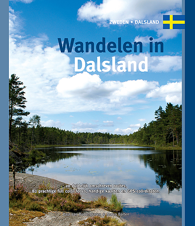
<p> Dalsland, dat is ‘Zweden in het klein’, wordt wel beweerd. Je vindt er alles wat Zweden te bieden heeft, allemaal op goed bereikbare afstand. De beste manier om te ontdekken wat Dalsland te bieden heeft, is door erop uit te trekken in de weidse natuur. Met deze gids in je hand heb je de beschikking over twintig gedetailleerd beschreven rondwandelingen, variërend in duur van een paar uur tot een hele dag. De wandelingen zijn verspreid over de hele provincie, zodat er altijd wel een paar in de buurt zijn.</p> <p> Het boekje, met 20 wandelingen, 82 prachtige full colour foto's van alle bezienswaardigheden, handige kaarten en GPS-coördinaten</p>
€16,95
Bekijk product
<p> Uitstekende routegids met gedetailleerde kaarten en een routebeschrijving. Fout lopen wordt op deze manier wel erg moeilijk. Met symbolen is weergegeven welke voorzieningen (openbaar vervoer / winkels / overnachtingen) er zijn langs of bij de route. Een nadeel is dat de daadwerkelijke adressen dan weer niet altijd genoemd worden. Alle gidsen bevatten een door ons toegevoegde uitgebreide frans - nederlandse wandelwoordenlijst.</p> <p> Ancienne voie de pèlerinage, au même titre que les chemins de Saint-Jacques ou du Mont-Saint-Michel, ce topo-guide bilingue français/anglais (une grande première !) comprend les 245 premiers kilomètres français de l'itinéraire ancestral reliant Canterbury à Rome. </p> <p> <span style="font-size: 12px;">Il est proposé des étapes d’environ 20 kilomètres entre Calais et Rocquigny, privilégiant des sentiers de petites et de grandes randonnées pédestres existants et reconnus pour leurs qualités : faible taux de bitume, mais surtout favorisant la découverte des paysages et du patrimoine.</span></p> <div> <span style="font-size: 12px;">De Calais, le randonneur reliera Wissant, le long du GR® du Littoral de la Côte d’Opale. C’est ensuite l’étape de Wissant à Guînes entre la plaine de Flandres et les derniers contreforts du boulonnais. De Guînes, c’est un itinéraire au cœur des Trois-Pays qui nous mènera sur les pas des moines de l’Abbaye de Licques.</span></div> <div> </div> <div> <span style="font-size: 12px;">GR-145 GR145</span></div>
€19,95
Bekijk product
<p> Franstalige wandelgids met een beschrijving van een aantal dagtochten / rondwandelingen. Uitstekende beschrijvingen met duidelijk kaartmateriaal. Mislopen is nauwelijks mogelijk, maar ja .. de franse taal! Ook praktische informatie staat in deze gids. Alle gidsen bevatten een door ons toegevoegde uitgebreide frans - nederlandse wandelwoordenlijst.</p> <p> "Robe de bure et cotte de maille"… un intitulé pour le moins énigmatique pour un GR® de Pays ! Lieux de culte - la bure - et châteaux - la cotte de maille - tels sont les édifices que cette boucle de 9 jours vous invite à découvrir dans cette moitié ouest de la Haute-Loire, un département décidément remarquable par le nombre et la qualité de ses itinéraires pédestres ! </p> <p> </p> <div> Vingt-huit édifices religieux, dont l'abbaye de La Chaise-Dieu, rivalisant par leur architecture, leurs fresques et leur mobilier, et sept châteaux, dont celui du marquis de la Fayette, héros de l'Indépendance des États-Unis, vous attendent sur ce circuit en Haute-Loire !</div> <div> </div> <div> Le Conservatoire de la flore sauvage du Massif central, celui du saumon sauvage, un autre des cépages, des musées, de vieux villages parfois fortifiés, des paysages volcaniques, une multitude de rivières et de ruisseaux limpides, de grandes forêts peuplées de cervidés, des rapaces dans l'azur, une flore bigarrée... Relevez le heaume, ôtez la capuche, humez l'air pur et ouvrez bien grand les yeux !</div>
€17,50
Bekijk product