
Beantwoord enkele vragen, en binnen seconden geeft AI je een persoonlijk aankoopadvies op maat.
Beantwoord enkele vragen, en binnen seconden geeft AI je een persoonlijk aankoopadvies op maat.

<div> Take a trip on 28 beautiful walks across Sherwood Forest & East Midlands with the OS Pathfinder Guidebooks, graded by length and ranging from 3 to 11 miles.</div> <div> </div> <div> The area comprises of Nottinghamshire, Leicestershire, Rutland, and Northamptonshire. The routes range from extended strolls to longer hikes, something for all levels! Each walk includes a detailed description, an OS map, GPS waypoints and notes of key features and things to see.</div> <div> </div> <div> Routes include the Nene Valley, Geddington Chase, Rutland Water and Bosworth battlefield.</div> <div> </div> <div> This is one of a series of books with great walking routes covering the most popular and scenic areas of Britain. Printed with weather-resistant covers featuring durable rounded corners, they are the perfect companion for country walking throughout Britain.</div>
€18,50
Bekijk product
<div> 175 miles of delightfully pastoral country walking from Thurstaston Common on the Wirral to Tegg's Nose on the north-western fringes of the Peak District National Park . . .</div> <div> </div> <div> Uncover 28 beautiful walks around Cheshire with the OS Pathfinder Guidebooks, graded by length and ranging from 3 ½ to 10 ½ miles.</div> <div> </div> <div> The routes range from extended strolls to longer hikes, something for all levels! Each walk includes a detailed description, an OS map, GPS waypoints, and notes of key features and things to see.</div> <div> </div> <div> This is one of a series of books with great walking routes covering the most popular and scenic areas of Britain. Printed with weather-resistant covers featuring durable rounded corners, they are the perfect companion for country walking throughout Britain.</div> <div> </div> <div> Publication Date: 2019</div> <div> </div> <div> Walks in this book:</div> <div> </div> <ul> <li> Wirswall Hill and Big Mere</li> <li> Bollington and Nab Head</li> <li> Little Budworth Country Park</li> <li> Styal and the Bollin Valley</li> <li> Dane Valley</li> <li> Chester and the River Dee</li> <li> Boothsdale</li> <li> Astbury mere and Village</li> <li> Delamere Forest</li> <li> Audlem and the Shropshire Union Canal</li> <li> Bulkeley Hill and Raw Head</li> <li> Sandbach</li> <li> Disley and Lyme Park</li> <li> Dunham Park and the Bridgewater Canal</li> <li> Wybunbury</li> <li> Farndon and Churton</li> <li> Gawsworth Hall and North Rode</li> <li> Trent and Mersey Canal and Great Budworth</li> <li> Beeston Castle and the Shropshire Union Canal</li> <li> Caldy Hill, Thurstaston and the Wirral Way</li> <li> Wirral Way, Parkgate and the Dee Estuary</li> <li> Above Helsby and Frodsham</li> <li> Mow Cop and Litle Moreton Hall</li> <li> Timberbrook and the Cloud</li> <li> Shutlingsloe</li> <li> Mapas</li> <li> Tegg's Nose and Macclesfield Forest</li> <li> Etherow and Goyt Valley</li> </ul>
€18,50
Bekijk product
<div> 200 miles of inland and coastal walking visiting windpumps and watermills . . .</div> <div> </div> <div> Walk 28 beautiful trails across Norfolk with the OS Pathfinder Guidebooks, graded by length and ranging from 3 ¾ to 11 miles.</div> <div> </div> <div> The routes range from extended strolls to longer hikes, offering something for all levels! Explore the area including the stunning coastal scenery in the north of the country, such as the unique inland waterways of the Broads to the east and the remote beauty of the vast fenlands to the west.</div> <div> </div> <div> Walking routes include some historic highlights: Castle rising and Oxburgh Hall, as well as ancient routes such as Boudicca's and the Peddars way. You can also discover stunning seascapes at Overstand and Wells-next-the-Sea.</div> <div> </div> <div> Each walk includes a detailed description, an OS map, GPS waypoints and notes ofkey featuresand things to see.</div> <div> </div> <div> Publication Date: 2019</div> <div> </div> <div> Walks in this book:</div> <div> </div> <ol> <li> Horsey</li> <li> Binham Priory</li> <li> Oxborough and Gooderstone</li> <li> Hales Green from Loddon</li> <li> Marham Fen and the Nar Valley Way</li> <li> Tyrrel's Wood and Shelton</li> <li> Felbrigg Park and Metton</li> <li> Langmere and the Devil's Punchbowl</li> <li> River Bure and Upton Marshes</li> <li> How Hill and Ludham</li> <li> The Buckenhams</li> <li> Hardley Cross</li> <li> Blickling and the River Bure</li> <li> Peddars Way Fring and Sedgeford</li> <li> Castle Acre and West Acre</li> <li> Boudca's Way Shotesham & Saxlingham Nethergate</li> <li> Thompson Common and the Pingos</li> <li> Westwick Woods and the Weaver's Way</li> <li> West Runton and Beacons Hill</li> <li> Wiveton Downs and Cley next the Sea</li> <li> The Burnhams</li> <li> Denver Sluice a three rivers walk</li> <li> Wells-next-the-Sea, Warham, and Wighton</li> <li> The Weaver's Way to The Berney Arms</li> <li> Reepham, Marriott's Way, and Salle</li> <li> Weeting Castle and Grime's Graves</li> <li> Castle Rising and Roydon Common</li> <li> Ringstead Downs and the Norfolk Coast</li> </ol>
€18,50
Bekijk product
<div> Explore 28 beautiful walks across Cambridgeshire and the Fens with the OS Pathfinder Guidebooks, graded by length and ranging from 3 to 11 miles.</div> <div> </div> <div> It is the flattest place in the country - but there is still a lot of landscape to discover. The Fens cover a large section of Cambridgeshire, with low-lying wetlands, tranquil riverside scenery, charming towns, villages, and country houses. The area is rich in heritage, wildlife and history just waiting to be discovered.</div> <div> </div> <div> Each walk includes a detailed description, an OS map, GPS waypoints and notes of key features and things to see.</div> <div> </div> <div> This is one of a series of books with great walking routes covering the most popular and scenic areas of Britain. Printed with weather-resistant covers featuring durable rounded corners, they are the perfect companion for country walking throughout Britain.</div>
€18,50
Bekijk product
<div> Immerse yourself in 28 beautiful walks along the South West Coast of England with the OS Pathfinder Guidebooks, graded by length and ranging from 3 to 9 miles.</div> <div> </div> <div> The routes range from extended strolls to longer hikes, something for all levels! Each walk includes a detailed description, an OS map, GPS waypoints and notes of key features and things to see.</div> <div> </div> <div> Routes include Lulworth Cove, Old Harry rocks, Chesil beach, Lizard Point, and Sidmouth.</div> <div> </div> <div> This is one of a series of books with great walking routes covering the most popular and scenic areas of Britain. Printed with weather-resistant covers featuring durable rounded corners, they are the perfect companion for country walking throughout Britain.</div>
€18,50
Bekijk product
<div> This companion to the Pathfinder Peak District Guidebook contains 28 additional circular walks of 3 to 10.5 miles. Like the main book, each is graded length difficulty, and ranger from relatively easy strolls to some of the more challenging routes with considerable vertical ascent.</div> <div> </div> <div> Each route includes a detailed description, a clear, large scale OS map, GPS waypoints and details of where to park, good pubs, and places of interest en route. Routes featured in the book include Stanage Edge, Jacob's Ladder, Lantern Pike, and Stanton Moor.</div>
€18,50
Bekijk product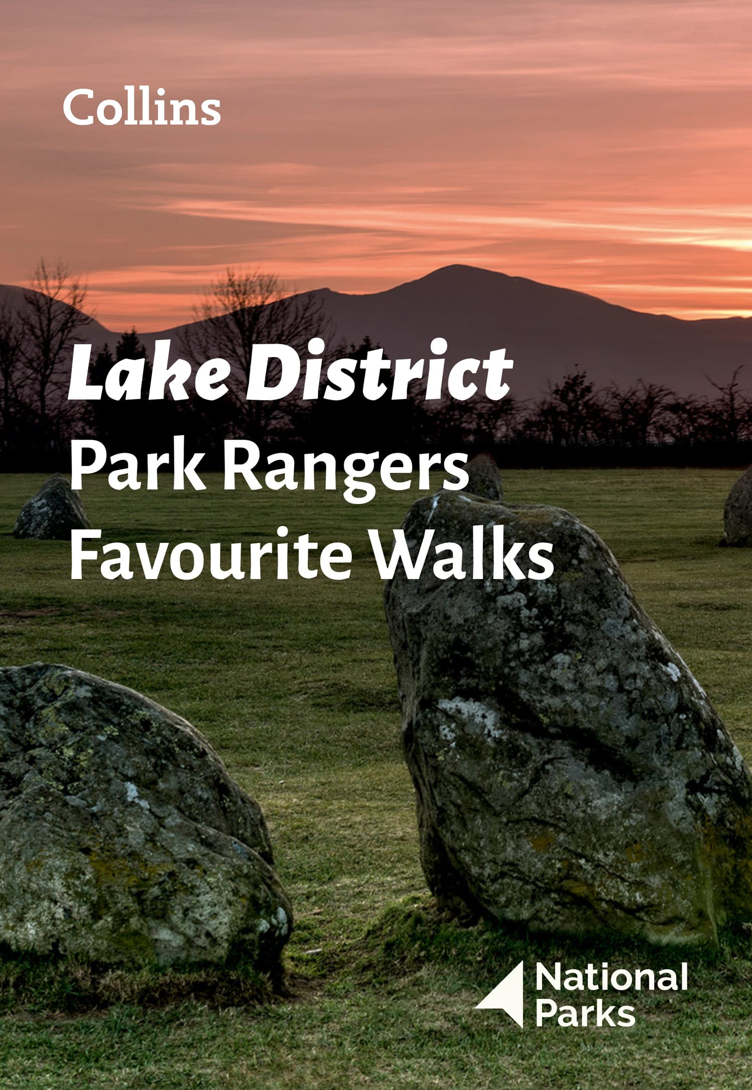
<div> Walking guide to the Lake District National Park, with 20 best routes chosen by the park rangers. Each walk varies in length from 2 to 10 km and can be completed in less than 4 hours.</div> <div> </div> <div> 20 best routes chosen and written by National Park rangers</div> <div> </div> <ul> <li> Walks from 2 to 10km</li> <li> Detailed description for each walk with highlights clearly marked on the map along with an accompanying map and photographs</li> <li> General information about the National Park plus basic advice on walking</li> <li> This and the Lake District National Park Pocket Map (ISBN: 9780008462673) are the perfect companions for exploring this superb walking area of Northwest England.</li> </ul>
€11,50
Bekijk product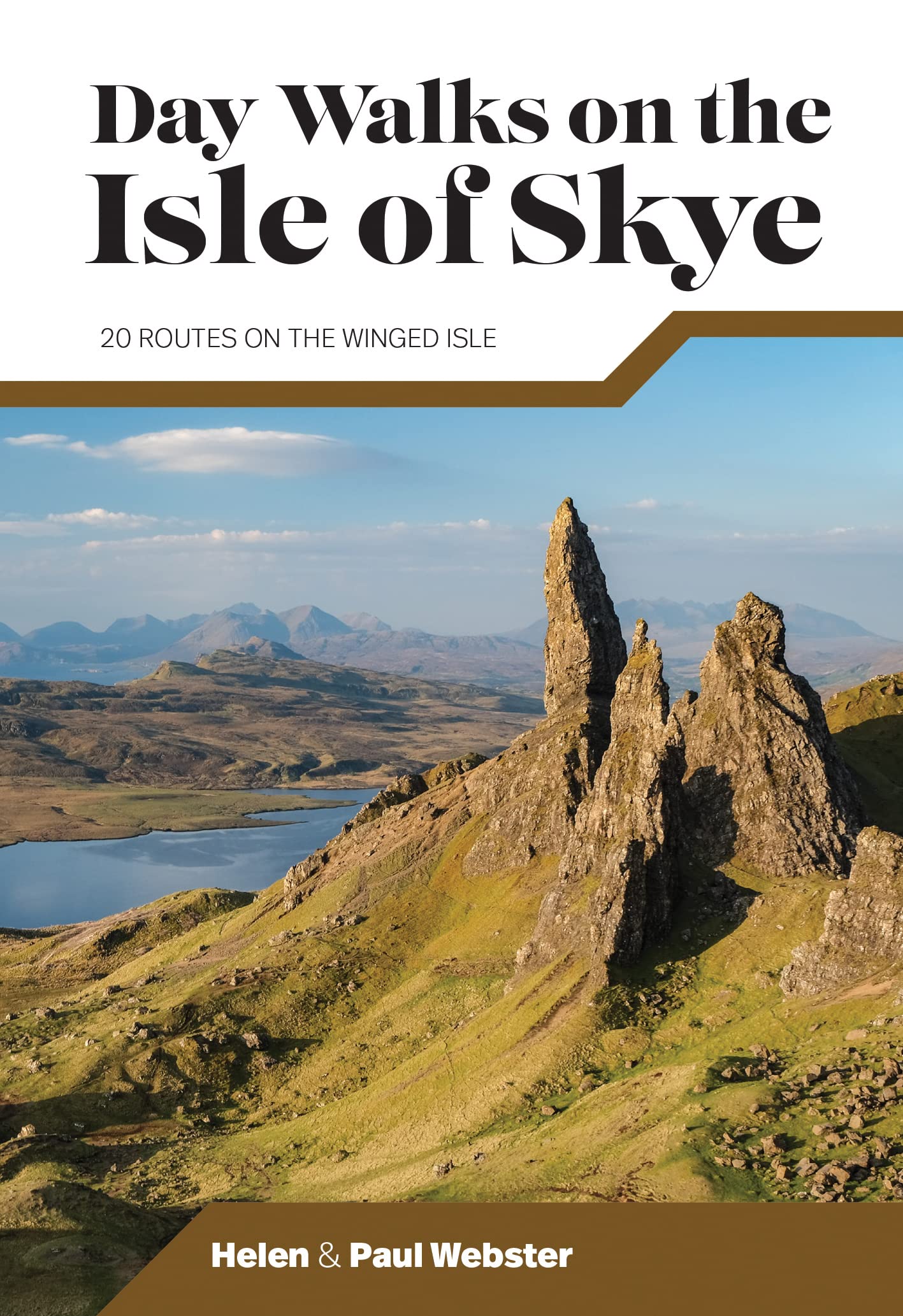
<div> Day Walks on the Isle of Skye features 20 routes between 3.4 and 14.5 miles (5.5km and 23.3km) in length, spread across the Isle of Skye with one walk on the neighbouring Isle of Raasay. Researched and written by experienced and knowledgeable authors Helen and Paul Webster, founders of the Walkhighlands website, the walks explore the rugged mountains and wildlife-rich coastline of the islands.</div> <div> </div> <div> The routes are split into four sections – Trotternish and the Braes; North-West Skye; Glen Brittle and Sligachan; and South Skye and the Isle of Raasay.</div> <div> </div> <div> Together with stunning photography, each route features Ordnance Survey 1:25,000 maps, easy-to-follow directions, details of distance and navigation information, and refreshment stops and local information.</div>
€19,95
Bekijk product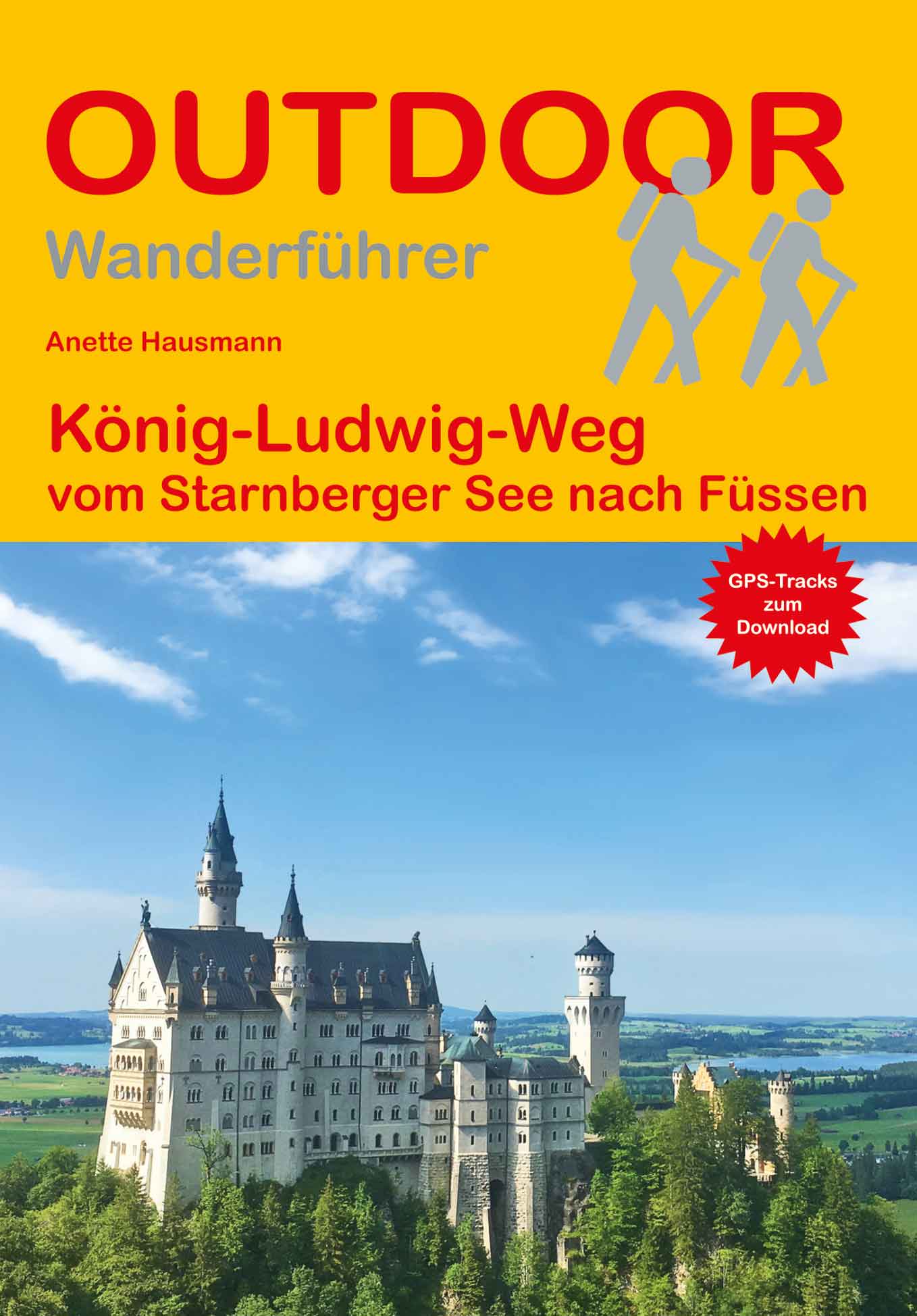
<p> Kleine handzame wandelgids van een gerenommeerde Duitse uitgever: veel praktische informatie, hoogteprofielen per etappe en redelijk kaartmateriaal.</p> <div> Der 130 km lange König-Ludwig-Weg, gewidmet dem bayerischen König Ludwig II., führt in 6 Etappen durch eine der schönsten Landschaften Bayerns bzw. ganz Deutschlands von Starnberg nach Füssen. Auf den Spuren des "Märchenkönigs" wandern Sie über sanfte Hügel und an klaren Badeseen vorbei, immer wieder mit aussichtsreichen Blicken auf das Hochgebirge der Allgäuer Alpen. Imposante Schluchten wie die Maisinger Schlucht und Ammerschlucht und die mystischen Moorlandschaften des Pfaffenwinkels gehören zu den Wanderhighlights. Das Weltkulturerbe Wieskirche sowie die Klöster Andechs, Wessobrunn, Rottenbuch und Steingaden bieten besondere kunsthistorische Einblicke. Der Weg bringt Sie über den Hohen Peißenberg bis nach Füssen, vorbei an den sagenumwobenen Schlössern Hohenschwangau und Neuschwanstein.Der Wanderführer beinhaltet detaillierte Karten, Höhenprofile, eine Übersichtskarte und GPS-Tracks zum Download und gibt praktische Tipps zur Anreise, Ausrüstung und Wegbesonderheiten sowie Wandervarianten, die bei der Tourenplanung helfen.</div> <div> </div> <div> Unterwegs auf "Kinis" Weg, Land und Leute, Reise-Infos von A bis Z, Der König-Ludwig-Weg in 6 Etappen.</div>
€13,50
Bekijk product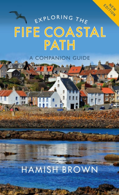
<p> This is the ideal guide to the whole route, so rich in history and natural beauty. Designed to be used by walkers on the Path or visitors to any point along it, it introduces a wealth of castles, churches, harbours, monuments and red-roofed houses.<br /> <br /> Hamish Brown gives practical advice on all aspects of walking the Path, whether you are making a seven-day trip along its whole length or walking a short section on a Sunday afternoon. Revising his earlier guide to the route, he explores every part of the Fife coast, including the famous Forth bridges, the charming East Neuk fishing villages of Pittenweem, Elie and St Monans, as well as Anstruther, Crail and St Andrews. Along the way he provides a mass of fascinating information about people and places that can be read for pleasure and kept as the souvenir of a unique and unforgettable part of Scotland.</p>
€20,95
Bekijk product