
Beantwoord enkele vragen, en binnen seconden geeft AI je een persoonlijk aankoopadvies op maat.
Beantwoord enkele vragen, en binnen seconden geeft AI je een persoonlijk aankoopadvies op maat.

<p> <span style="color: rgb(0, 0, 0); font-family: "Helvetica Neue", Helvetica, sans-serif, Arial;">Duitstalige wandelgids van de Rhein Neckar met zeer goed beschreven wandelingen in de wandelgebieden. Redelijk kaartmateriaal, vooral de beschrijving van de route en de praktische info die er bij hoort is goed.</span></p> <p> In der Region am Oberrhein, rund um die Mündung von Neckar in den Rhein, gibt es eine Fülle verlockender Ziele für Spaziergänger und Wanderer. Die einladend schöne Region an Rhein und Neckar mit seinen alten Flussarmen ist geprägt von Hügeln, Burgen und phantastischen Ausblicken. Die schönsten Wanderungen in der Kurpfalz, zwischen Pfälzer Weinstraße, Odenwald, Bergstraße und Kraichgau stellt dieser Rother Wanderführer vor.</p> <p> Im Zentrum der Region liegt Heidelberg, Stadt der Poeten, Studenten und Wissenschaften. Die historische Touristenmetropole am malerischen Austritt des Neckars aus dem Odenwald, hält allein schon eine Handvoll der schönsten Wanderungen bereit. Auch die weitere Region lädt zu schönen Wanderungen ein: Die vorgestellten Touren verlaufen längs des tief in den Buntsandstein eingegrabenen Neckars, auf Höhenwegen in Kraichgau und Odenwald und zwischen Reben und Edelkastanien an der Bergstraße und in der Pfalz. Spuren der Römer, mittelalterliche Burgen und Ruinen mit phantastischen Tal- und Fernblicken sorgen für abwechslungsreiche Stunden in der Natur.</p> <p> Alle Touren werden mit zuverlässigen Wegbeschreibungen, aussagekräftigen Streckenprofilen und detaillierten Wanderkärtchen vorgestellt. Hinzu kommen GPS-Daten zum Download von der Internetseite des Bergverlag Rother.</p> <p> Besonders interessant: der Wanderführer liefert auch viele Infos zu seltenen geologischen Formationen, botanischen Raritäten und kunsthistorischen Zielen.</p>
€18,50
Bekijk product
<p> Uitstekende wandelgids met gedetailleerde kaarten en een routebeschrijving. Fout lopen wordt op deze manier wel erg moeilijk. Met symbolen is weergegeven welke voorzieningen (openbaar vervoer / winkels / overnachtingen) er zijn langs of bij de route. Een nadeel is dat de daadwerkelijke adressen dan weer niet altijd genoemd worden. Alle gidsen bevatten een door ons toegevoegde uitgebreide frans nederlandse wandelwoordenlijst. Dagtochten!</p> <p> 43 randonnées en Haute-Loire pour parcourir une nature préservée : gorges de l'Allier, gorges de la Loire, le Puy-en-Velay...</p> <div> Dans le midi de l’Auvergne, la Haute-Loire propose une variété surprenante de paysages et de panoramas façonnés par le volcanisme et les cours d’eau.</div> <div> </div> <div> 43 promenades pour découvrir des villages de caractère et une nature préservée.</div> <div> </div> <div> Le Puy-en-Velay, niché entre les plateaux et les gorges de la Loire, dresse des monuments inscrits au patrimoine mondial de l’Unesco comme des phares sur le chemin de Saint-Jacques-de-Compostelle.</div>
€18,50
Bekijk product
<p> Franstalige wandelgids (met Ned. woordenlijst) met gedetailleerde kaarten, routebeschrijvingen en wetenswaardigheden. Fraai geillustreerd.</p> <div> Le territoire concerné</div> <div> </div> <div> Couverture harmonieuse de tout le département, de l’Albigeois (Albi est classée Patrimoine Mondial de l’Unesco depuis août 2010), aux monts de Lacaune en passant par la Montagne Noire, le Lauragais, l’ancienne région minière de Carmaux, le Parc Naturel Régional du Haut-Languedoc et les gorges du Viaur ou de l’Aveyron.</div> <div> Le département du Tarn est mitoyen de la Haute-Garonne. L’agglomération de Toulouse (4ème ville de France) est située à moins d’une ½ heure en voiture.</div> <div> </div> <div> Le guide</div> <div> </div> <div> * 48 pages</div> <div> * Format pratique : 12 x 21 cm</div> <div> * Introduction générale avec présentation du territoire (plusieurs thèmes développés qui enrichissent la connaissance des sites traversés)</div> <div> * 19 itinéraires de 1 h 30 à 5 h 00 pour une pratique familiale et sportive + 1 découverte pédestre du cœur historique d’Albi</div> <div> * Cartographie sur fond IGN au 1 : 25 000 pour se repérer facilement</div> <div> * Détail des centres d’intérêts</div> <div> * Renseignements pratiques pour randonner en toute sécurité</div> <div> * Adresses utiles.</div>
€11,50
Bekijk product
<p> Handige en volledige gids voor Toscane van de bekende uitgever Sunflower, met 8 mooie autoroutes en 26 wandelingen. Daarnaast boordevol tips voor wandelaars en achtergrondinformatie, autokaarten en wandelkaartjes.</p> <div> This guide book is designed for visitors walking in Tuscany and touring Tuscany by car. While the region’s historic towns and architectural highlights are often the focal points for these excursions, the role of the Tuscan peasant in creating this glorious landscape is stressed throughout — especially in the wealth of background information about Tuscany’s customs and cuisine, flora, fauna and history — all of them illustrated.</div> <div> </div> <div> The book should be particularly suitable for those who wish to combine a visit to Florence with seeing the Italian countryside (you’ll need a good city guide for Florence, while this ‘Landscapes’ guide will show you the best of the rural scene.)</div> <div> </div> <div> Area covered: from the Carrera marble quarries in the northwest down to southern Tuscany, with a particular emphasis on the area round Florence and in the Chianti.</div> <div> </div> <div> The best months for walking in Tuscany are from September to June.</div>
€19,50
Bekijk product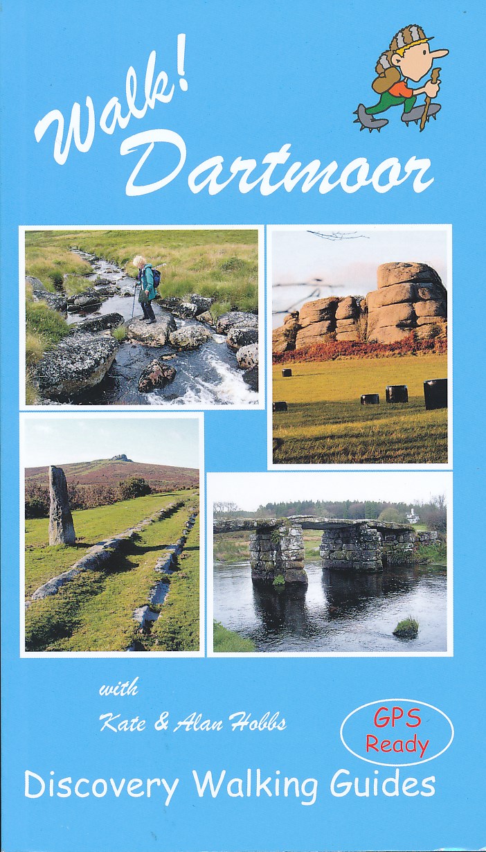
<p> Engelstalige wandelgids voor Dartmoor, met uitgebreide beschrijvingen van wandelroutes, routekaartjes, praktische informatie zoals bussen en accommodatie.</p> <div> Kate and Alan Hobbs have reviewed and refreshed their Walk! Dartmoor classic guide book for its new 2016 edition. 40 fully detailed walking routes with OS maps and gps waypoints for you to enjoy adventuring on Dartmoor. Walk! Dartmoor with Kate and Alan Hobbs covers walks of varying length across Dartmoor - from the dramatic high moors, gentle riversides, idyllic country lanes, unspoilt villages, to sites of ancient archaeology and former industries, and all with spectacular views.</div> <div> </div> <div> This user friendly illustrated guide has a summary of walking routes and is rated by time, effort, distance and hills, as well as the availability of refreshments en route and the vertigo risk.Each walk is described in full and there are timings listed in the book to help with navigation and progress. Walk! Dartmoor contains a 1:40,000 scale Ordnance Survey map for each route. Within the heart of Devon lies Dartmoor's 365 square miles of natural beauty, one of the largest areas of exposed granite in southern England.</div> <div> </div> <div> Apart from its spectacular scenery, Dartmoor is rich in flora and fauna.Come with us to explore Dartmoor's dramatic high moors, gentle riversides, idyllic country lanes and unspoilt villages, discovering spectacular views, ancient archaeology and traces of bygone industries. All 40 walking routes include: walking route summary, ratings for Effort Time Distance Ascents/Descents Refreshments and Vertigo risk, fully detailed walk description including frequent timings to aid navigation and check your progress, GPS waypoints at every key point on every route, full colour 1:40,000 scale Ordnance Survey licenced mapping for each route, short walk and stroll alternatives.</div>
€19,95
Bekijk product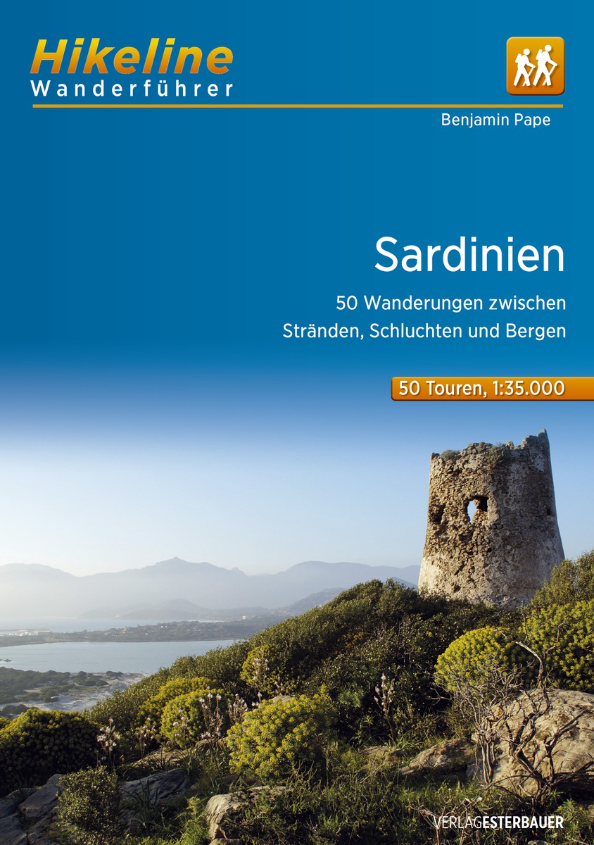
<p> Handzame gids met een goede beschrijving van een groot aantal dagtochten in dit gebied. </p> <p> Das vorliegende Buch beschreibt 50 Touren in allen Gebieten der Insel, konzentriert sich jedoch primär auf die attraktiven und mit einer minimalen Tourismus-Infrastruktur ausgestatteten Berg- und Hügelregionen. Sardinien ist eine Flächeninsel, auf der die Tourismusgemeinschaften häufig erstaunlich lange Streckentouren ausweisen. Wir haben großen Wert auf eine geringe Zahl an Stichtouren und eine Mehrheit von Rundtouren gelegt. Die Touren sind deshalb meist über 10 bis zu 19 Kilometer lang und beinhalten, abgesehen von einer reinen Talwanderung, 150 bis 800 Steigungsmeter, so dass vom Spaziergang zur ausgewachsenen Ganztagswanderung für jeden etwas dabei ist. Soweit möglich, enthalten die Tourbeschreibungen Hinweise zur Anfahrt mit öffentlichen Verkehrsmitteln und die nächstgelegenen – manchmal aber bis zu 15 km entfernten – Einkehrmöglichkeiten. Zur logischen Gliederung wurden die Touren in vier Teilgebiete sortiert. Die Gebiete entsprechen den Hauptgebirgsketten der Insel von Norden nach Süden: Die Touren 1 bis 14 behandeln fast die gesamte Nordhälfte der Insel, nördlich der Linie Oristano-Nuoro-Orosei gelegen. In diesem Inselteil finden Sie Touren in der Gallura, am Monte Acuto und Monte Limbara, aber auch an diversen Kaps der touristisch sehr interessanten Küste. Der relativ kleinen, für den Wandertourismus aber höchst attraktiven Region des Supramonte-Massivs sind die Touren 15 bis 24 gewidmet. Direkt westlich davon schließt sich das „Dach der Insel“, das Gennargentu-Massiv mit den hochinteressanten Barbagia-Hochebenen an, das mit den etwas außerhalb liegenden Vulkanbergen zum dritten Tourgebiet mit den Wanderungen 25 bis 35 zusammengefasst wurde. Das vierte Gebiet mit den Touren 36 bis 50 beinhaltet die drei südlichen, voneinander durch Tiefebenen getrennten Gebirgszüge: der Monte Linas und die Monti Sulcis bilden gemeinsam die historische Region Sulcis-Iglesiente im Südwesten Sardiniens, während im Südosten die Sette Fratelli-Berge den höchsten und interessantesten Teil des Hügellands darstellen.</p>
€13,50
Bekijk product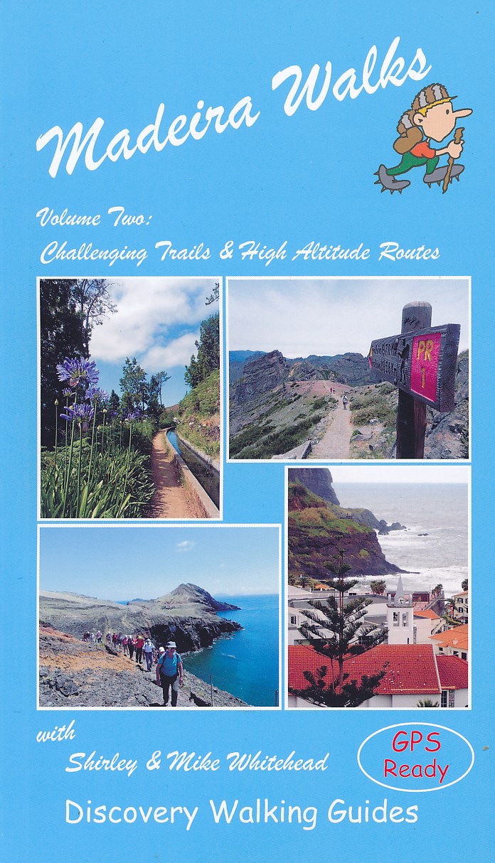
<p> Engelstalige wandelgids Madeira, met uitgebreide beschrijvingen van wandelroutes, routekaartjes en praktische informatie zoals bussen en accommodatie.</p> <p> In dit tweede deel staan de wat uitdagendere routes.</p> <div> As a walker's paradise, Madeira has it all - majestic mountains, rugged coastline, ancient forests, a unique levada network and verdant flora; easy to see why so many walkers return year after year. In 2015 Madeira was voted the "World's Best Island Destination" by the World Travel Awards the final accolade from the previous two years when it was voted "Europe's Leading Island Destination". Quite an achievement, brought about largely by the substantial EU investment over the past decade in the improvement and development of the island's infrastructure and facilities.</div> <div> </div> <div> One of the initiatives focused on improving and creating new walking trails which has resulted in Madeira now being regarded as one of Europe's top hiking destinations.To date, around thirty routes on Madeira have been designated Recommended Trails for Hikers and currently our guides are the only publications to include all these trails. We have also taken on board the many comments received from walkers over the last few years. Taking all the above into account, we've reorganized our books into a compendium of two editions; Madeira Walks: Volume One, Leisure Trails included the shorter and easier trails whilst Madeira Walks: Volume Two covers 40 more challenging and high altitude routes.</div> <div> </div> <div> There's a good balance including coastal routes, forest trails, moorland and mountain pathways and levada walks although the terrain varies greatly. We've introduced a number of new routes whilst continuing to include our favourite 'off the beaten track' trails, so regardless of fitness, age or ability, there's something for everyone. Both books are arranged by geographic area, then by exertion rating under each heading.</div> <div> </div> <div> All the trails have been surveyed and mapped using GPS satellite navigation. The authors and their co-walkers have walked all these routes and continue to revisit as many as possible, especially those we believe could be subject to change; this ensures accuracy and up to date information for hikers. Clear descriptions guide the walker both to the starting point and throughout the routes, with gradings, distances, timings and altitudes all symbolized.</div> <div> </div> <div> Whilst distances vary considerably, many of the routes have steep ascents or descents and a few are subject to some extremely precipitous sections. Some information on flora and fauna is also included, while references to places of interest give readers a sense of the culture and history around these trails. Map sections were developed from the Madeira Tour & Trail Map, by far the most up to date and best-selling map on the island.</div> <div> </div> <div> In addition to the walking trails, viewing platforms (miradouros) are found around the island providing strategic positions for taking in the most stunning views. Barbeque and picnic areas are also positioned in picturesque locations around the island.</div>
€19,95
Bekijk product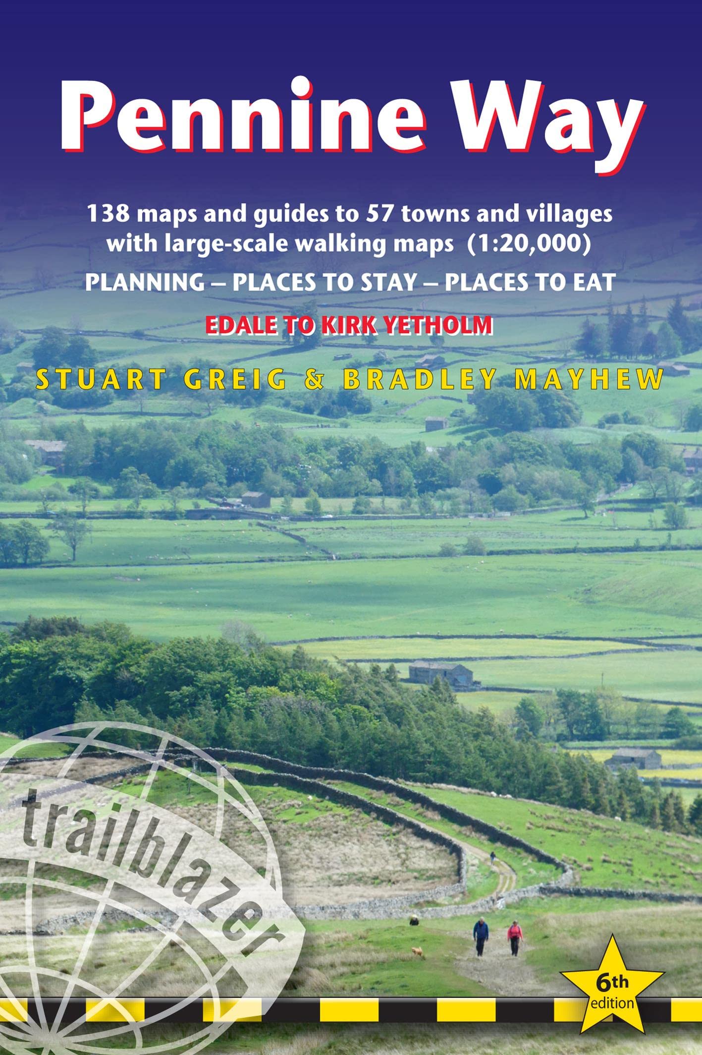
<div> Trailblazer British Walking Guide to the Pennine Way, Britain's best-known National Trail that winds for 256 miles through three National Parks - the Peak District, Yorkshire Dales and Northumberland. This superb footpath showcases Britain's finest upland scenery, while touching the literary landscape of the Bronte family and Roman history along Hadrian's Wall. 138 large-scale walking maps - at just under 1:20,000 - showing route times, gradients, where to stay, interesting features.</div> <div> </div> <div> Guides to 57 towns and villages - along the way. Itineraries for all walkers - whether walking the route in its entirety or sampling the highlights on day walks and short breaks. Practical information for all budgets - Edale to Kirk Yetholm.</div> <div> </div> <div> Where to stay with reviews - B&Bs, hostels, campsites, pubs and hotels. Where to eat with reviews. What to see, plus detailed town plans.</div> <div> </div> <div> Public transport information - for all access points on the path. GPS waypoints - also downloadable from the Trailblazer website. Extra colour sections: 16pp colour introduction and 16pp of colour mapping for stage sections (one stage per page) with trail profiles.</div>
€23,50
Bekijk product
<div> Route / Traject: Ribeauvillé - St Hippolyte</div> <div> </div> <div> Zowaar: prachtige en duidelijke Nederlandstalige gidsjes van telkens een traject van 2 weken. De boekjes beschikken over weliswaar schetsmatige maar gedetailleerde kaarten in kleur met ingetekende GR5-route, hoogteprofielen, en een Nederlandstalige routebeschrijving. Er is geen informatie over de omgeving opgenomen. Als je buiten de route van de GR5 gaat, dan is dit boekje niet voldoende. </div> <div> </div> <div> Absoluut een aanrader voor wie niet met de Franse taal overweg kan; ook als aanvulling op de Franse gidsen kan het nuttig zijn. </div> <div> </div> <div> GR5 GR-5 GR 5</div>
€19,50
Bekijk product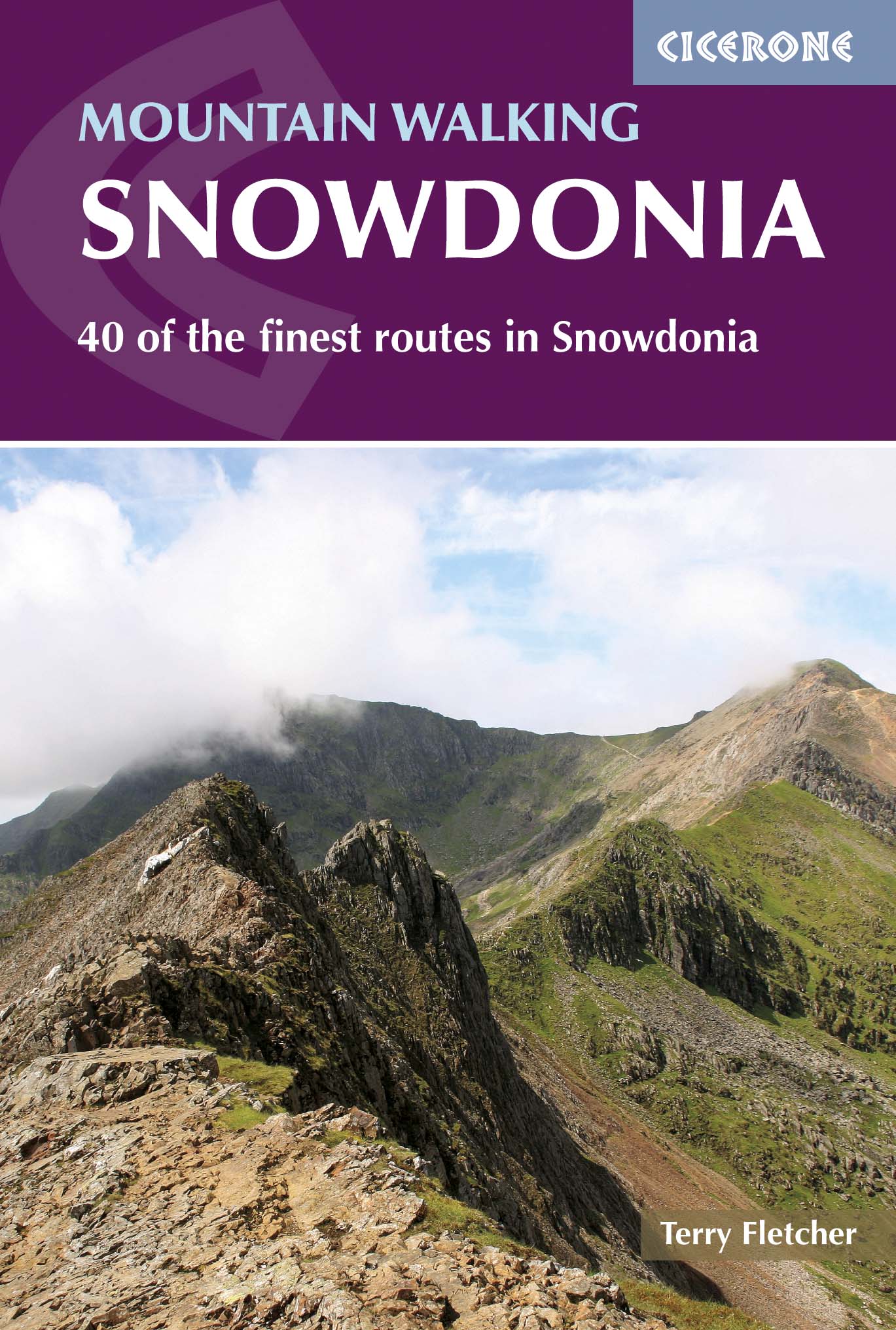
<p> Uitstekende wandelgids voor dit uitdagende wandelgebied in Wales. 38 dagtochten en een tweedaagse tocht.</p> <div> This guidebook describes 40 day walks exploring Snowdonia. It showcases some of the best mountain walks in the area, with routes up Snowdon and Tryfan alongside other classic peaks like Y Garn, Cadair Idris and the Glyders. Routes are graded easy to strenuous and include airy and pulse-quickening scrambles such as Crib Goch and Bristly Ridge as well as the Snowdon Horseshoe, the Nantlle Ridge and a 2-day traverse of all 15 of Snowdon’s peaks over 3000ft.</div> <div> </div> <div> Walks range in distance from 4 miles (6km) to 16 miles (26km). Clear route descriptions are accompanied by OS mapping, and for each walk there is key information about distance, grade, ascent, terrain, access and parking. With useful advice on where to stay and when to go, and an English-Welsh glossary, this book is an invaluable guide to discovering both the popular and less well-trodden corners of Snowdonia.</div> <div> </div> <div> Snowdonia can justifiably lay claim to some of the finest mountain walking in Britain, from the bristling, jagged ridges of Snowdon to the huge grassy mounds of the Carneddau and the stone-girt fortresses of the Glyderau. These are big mountains with big personalities, with glowering crags and deep rocky cwms. Whether you are based in Bala, Beddgelert, Llanberis, Betws-y-Coed, Dolgellau or Capel Curig, you’ll find walks in this guidebook to suit you.</div> <div> </div> <div> <strong>Steden en Dorpen</strong></div> <div> Ogwen, Betws y Coed, Capel Curig, Llanberis, Harlech, Dolgellau, Bethesda, Beddgelert and Bala areas as well as coastal resorts of North and West Wales.</div>
€23,50
Bekijk product