
Beantwoord enkele vragen, en binnen seconden geeft AI je een persoonlijk aankoopadvies op maat.
Beantwoord enkele vragen, en binnen seconden geeft AI je een persoonlijk aankoopadvies op maat.

<p> Uitstekende wandelgids van dit geweldige gebied. goed beschreven met veel praktische informatie om de route te kunnen lopen, inclusief redelijke kaarten. Bedenk wel - zie het overzicht- dat het voornamelijk routes zijn in het westen en zuiden van Oostenrijk.</p> <div> A comprehensive guidebook detailing walking routes in Austria. The 101 walks reflect the diversity of this popular region and cover Austria's magnificent Alps - including the Rätikon, Silvretta, Stubai and Zillertal - as well as the Dachsteingebirge, Hohe Tauern and the Karawanken. Graded according to difficulty and ranging from short walks of a few kilometres to day hikes and multi-day hut-to-hut tours, from the classic to the lesser-known, there is something to suit every level of ability and ambition. </div> <div> </div> <div> A full description of each route is accompanied by clear sketch maps. This book has all the information you need to make the most of an active walking holiday in Austria, including information on public transport, accommodation, gear required and safety issues, full details of over 100 mountain huts and a German–English glossary. </div> <div> </div> <div> Austria is one of Europe's most walker-friendly countries. Its 40,000km of well-maintained and waymarked trails pass more than a thousand Austrian mountain huts and countless attractive villages, hospitable hotels, inns and restaurants. It also boasts an extensive, integrated public transport system that is particularly useful for walkers. The Austrian landscape is enchanting in its beauty, featuring rugged limestone spires, towering snowy peaks, majestic lakes and tranquil valleys.</div> <div> </div> <div> <strong>Steden en Dorpen</strong></div> <div> <div> Brand, Schruns, Tschagguns, Gargelle, St Gallenkirch, Gaschurn, Bielerhöhe, Galtür, Ischgl, Feichten, Plangeross, Mandarfen, Längenfeld, Sölden, Obergurgl, Längenfeld, Kühtai, Gries im Sellrain, Neustift, Zell am Ziller, Mayrhofen, Finkenberg, Westendorf, Brixen, Kitzbühel, Söll, Scheffau, Ellmau, Saalbach, Hinterglemm, Zell am See, Kufstein, Scheffau, Ellmau, Going, St Johann in Tirol, Filzmoos, Ramsau, Hallstatt, Badgastein, Kaprun, Matrei in Osttirol, Kals am Grossglockner, Ferlach, Bad Eisenkappel</div> <div> </div> </div> <p> </p>
€24,95
Bekijk product
<p> Franstalige wandelgids. Uitstekende beschrijving met gedetailleerd kaartmateriaal (topografisch, IGN) en veel praktische informatie over zwaarte, hoogte en hutten. Bijna onmisbaar voor het lopen van deze route. In andere beschrijvingen zijn geen goede kaarten bijgevoegd! De gids bevat een lijst met overnachtingsadressen inclusief telefoonnummers en vaak websites en mailadressen.Wij leveren er een beknopte Frans-Nederlandse woordenlijst bij.</p> <div> La Loire est mondialement connue pour ses châteaux et ses jardins, aujourd'hui classés au Patrimoine mondial de l'Unesco. Le site du Val de Loire, berceau de la Renaissance, présente une densité exceptionnelle de monuments historiques des XVe et XVIe siècles.</div> <div> </div> <div> Dès l'époque du roi René d'Anjou, on rénove de vieilles demeures ou on leur adjoint des bâtiments nouveaux avec de larges fenêtres, des balcons et des escaliers ouvragés. On les entoure de jardins d'agrément qui donnent non seulement des fleurs mais aussi des fruits et des légumes pour accompagner le produit de la chasse.</div> <div> </div> <div> Plus tard, la présence de la Cour favorisera la construction de nombreux châteaux résidentiels. À côté de ces sites de notoriété internationale, le Val de Loire dispose d'un patrimoine touristique varié : paysages sauvages du fleuve, faune et flore des parcs et réserves, vastes forêts, habitat troglodytique, patrimoine de la viticulture et de la marine de Loire.</div>
€19,95
Bekijk product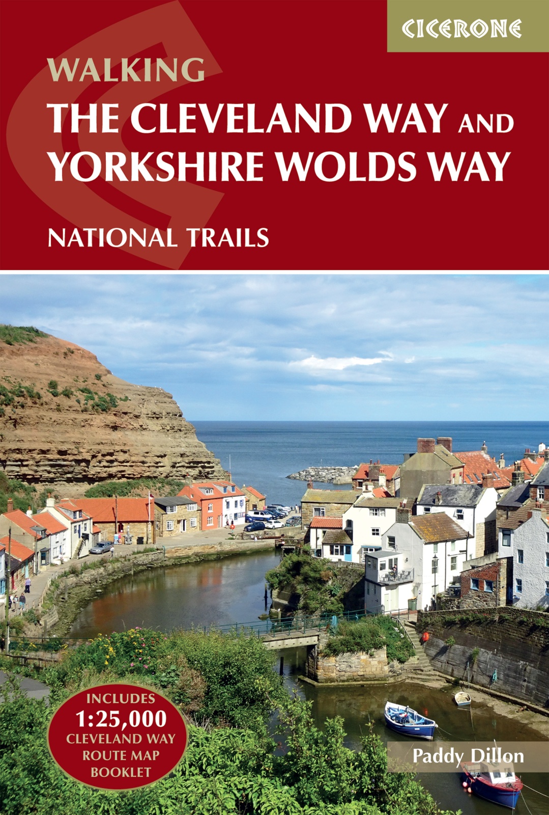
<p> Uitstekende wandelgids van de Cotswolds Way, waarbij naast alle noodzakelijke informatie ook gebruik gemaakt wordt van de echte topografische kaart. Inclusief gidsje met routekaarten van 1:25000</p> <div> Guidebook to the Cleveland Way and Yorkshire Wolds Way National Trails, plus the Tabular Hills Walk link route. The guidebook also contains a 1:25,000 scale OS route map booklet of the Cleveland Way.</div> <div> </div> <div> The Cleveland Way National Trail, described in seven day stages, is a fine 177km (110 miles) walk around the North York Moors National Park from Helmsley to Filey. The Yorkshire Wolds Way is one of the quietest of Britain's National Trails and wanders for 130km (80 miles) through gentle, cultivated and sparsely populated countryside. Described here in nine day stages, from Hessle near Redcar to Filey, it links end-to-end with the Cleveland Way on the coast. Also described is the three-day, 80km (50 mile) Tabular Hills Walk, a Regional Trail that allows walkers to close the loop of the Cleveland Way and transform it into an enormous circular walk.</div> <div> </div> <div> The guidebook comes with a separate map booklet of 1:25,000 scale OS maps showing the full route of the Cleveland Way. The clear step-by-step route description links together with the map booklet at each stage along the Way, and the compact format is conveniently sized for slipping into a jacket pocket or the top of a rucksack.</div> <div> </div> <div> <strong>Dorpen en Steden</strong></div> <div> Scarborough, Whitby, Filey, Helmsley, Osmotherley</div> <div> </div> <div> <strong>Inhoudsopgave</strong></div> <div> <div> The Yorkshire Wolds Way National Trail</div> <div> Stage 1 Hessle to South Cave</div> <div> Stage 2 South Cave to Goodmanham or Market Weighton</div> <div> Stage 3 Goodmanham or Market Weighton to Millington</div> <div> Stage 4 Millington to Thixendale</div> <div> Stage 5 Thixendale to Sherburn</div> <div> Stage 6 Sherburn to Filey</div> <div> Stage 7 Filey to Scalby Mills (via the Cleveland Way)</div> <div> </div> <div> The Tabular Hills Walk</div> <div> Stage 1 Scalby Mills to Levisham</div> <div> Stage 2 Levisham to Hutton-le-Hole</div> <div> Stage 3 Hutton-le-Hole to Helmsley</div> <div> </div> <div> The Cleveland Way National Trail</div> <div> Stage 1 Helmsley to Sutton Bank</div> <div> Stage 2 Sutton Bank to Osmotherley</div> <div> Stage 3 Osmotherley to Clay Bank</div> <div> Stage 4 Clay Bank to Kildale</div> <div> Stage 5 Kildale to Saltburn-by-the-Sea</div> <div> Stage 6 Saltburn-by-the-Sea to Sandsend</div> <div> Stage 7 Sandsend to Robin Hood’s Bay</div> <div> Stage 8 Robin Hood’s Bay to Scarborough</div> <div> Stage 9 Scarborough to Filey</div> </div> <p> </p>
€25,95
Bekijk product
<p> Uitstekende beschrijving van de Grande Traversata della Alpi, een doorgaande meerdaagse wandeltocht door de Italiaanse ALpen aan de westkant. Goede routebeschrijving, schetsmatige kaarten, vol met nuttige en praktische informatie.</p> <p> A guidebook to Italy's Grande Traversata Delle Alpi (GTA) trek through the western Italian Alps. The 809km (503 mile) route is presented in 55 stages with each stage ranging from 7-26km (4-16 miles). Beginning at the Nufenen pass at the Swiss border the route traverses the Lepontine, Pennine, Graian, Cottian and Maritime Alps to finish at Ventimiglia on the Mediterranean coast. With nearly 60,000m of ascent this route is suitable for fit and experienced alpine trekkers. This guidebook contains route description and 1:00,000 mapping for each stage as well as information on the region's history, culture and wildlife. Accommodation, facilities and public transport information is also given to help with trek planning. Italy's western Alps is an area of high mountain passes, sparkling lakes, clean air, and alpine meadows rich in wildflowers. With a network of paths that enabled travel long before the motor car, the region is ideally suited to exploring on foot. From Switzerland to the Mediterranean, the GTA enables the visitor to travel the old ways through the mountains, hearing the stories, sampling the regional specialties in food and wine, and experiencing the famously warm welcome of the Italian people.</p> <p> Content:</p> <p> Introduction<br /> The GTA Trek<br /> Italy’s Western Alps<br /> Piedmont<br /> Walking the GTA<br /> When to Go<br /> Getting There<br /> Local Transport<br /> How to Use this Guide<br /> Dos and Don’ts<br /> Emergencies<br /> Waymarking and Maps<br /> What to Take<br /> Accommodation<br /> Telephones<br /> Food and Drink<br /> Vegetation<br /> Wildlife</p> <p> GTA Route Description<br /> Part I: The Ligurian and Maritime Alps<br /> Part II: The Cottian Alps<br /> Part III: The Graian Alps<br /> Part IV: The Pennine Alps</p> <p> Route Summary</p> <p> Appendix I: Tourist Information<br /> Appendix II: Main Peaks along the GTA<br /> Appendix III: Italian–English Glossary<br /> Appendix IV: Further Reading</p> <p> </p>
€26,50
Bekijk product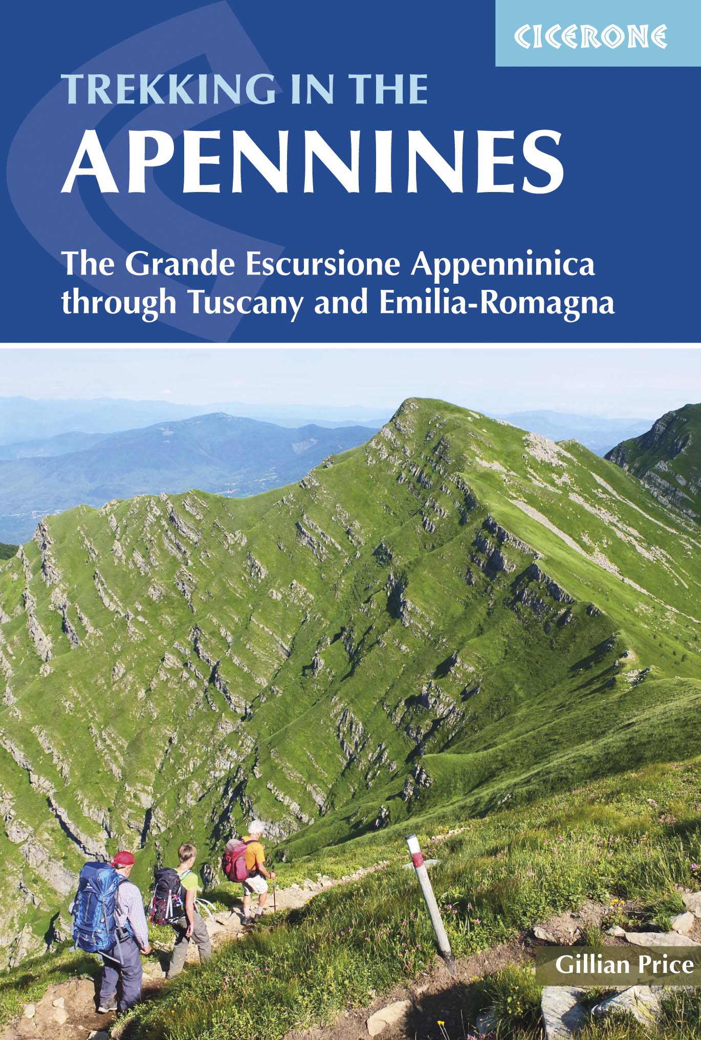
<p> Uitstekende wandelgids die in etappes de route nauwkeurig beschijft; ook de zijtakken en alternatieve routes koman aan bod. Kaarten zijn schetsmatig en in onze ogen onvoldoende bij slechte weersomstandigheden. Wij raden dan ook om er losse kaarten bij te kopen, voor zover verkrijgbaar!</p> <p> Guidebook to the Grand Apennines Trek, or Grande Escursione Appenninica (GEA). Through Tuscany and Emilia-Romagna and two National Parks, this 400km, 23 day trail explores the mountains, forests and hills of central Italy. Suitable for a range of walkers, it can be split into shorter sections or day walks if needed.</p> <div> This guidebook describes the Grande Escursione Appenninica (GEA), a nearly 400km long, three week trek crossing the Appenines in 23 stages, from Bocca Trabaria to Passo Due Santi on the edge of Liguria. The route dips in and out of Tuscany and Emilia-Romagna, never dropping below 400 metres. Best walked between spring and autumn, it is suitable for any reasonably fit walker. Highlights include Monte Prado – Tuscany's highest peak – friendly villages and comfortable hotel-style accommodation, memorable meals and yet few walkers, besides the Casentino National Park and Franciscan sanctuaries, the WW2 Gothic line, open ridges on the northern stretch, alpine-style lakes in the Apennines National Park, magnificent beech woods and alpine flowers.</div> <div> </div> <div> The guidebook provides step-by-step route descriptions, accompanied by detailed mapping. There are transport options for joining and leaving the walk at a number of points, making it perfect for undertaking in small sections or single-day walks. There are suggestions for accommodation en route in comfortable guest houses and alpine-style huts, making it essential reading for anyone undertaking the GEA.</div> <div> </div> <div> The Apennines are Italy's best-kept secret. Forming the rugged spine of the Italian peninsula, this range provides thousands of kilometres of marked trails over rocky crests and ridges and explores extensive forests and meadows, following routes established long ago by traders, pilgrims and shepherds and little affected by mass tourism. Dotted throughout are historic sanctuaries, national parks and nature reserves, wildlife and wildflowers, incredible roads and passes, and stark memorials to the terrible events of World War II. </div> <div> </div> <div> <strong>Dorpen en steden</strong></div> <div> Abetone, Arezzo, Bibbiena, Bologna, Parma, Pieve Pelago, Pistoia, Pontremoli, Porretta Terme, Prato, Reggio Emilia, Sansepolcro</div> <div> </div> <div> <strong>Etappes</strong></div> <div> <div> Stage 1 Bocca Trabaria to Passo di Viamaggio</div> <div> Stage 2 Passo di Viamaggio to Caprese Michelangelo</div> <div> Stage 3 Caprese Michelangelo to La Verna</div> <div> Stage 4 La Verna to Badia Prataglia</div> <div> Stage 5 Badia Prataglia to Rifugio Città di Forlì</div> <div> Stage 6 Rifugio Città di Forlì to Passo del Muraglione</div> <div> Stage 7 Passo del Muraglione to Colla di Casaglia</div> <div> Stage 8 Colla di Casaglia to Badia Moscheta</div> <div> Stage 9 Badia Moscheta to Passo del Giogo</div> <div> Stage 10 Passo del Giogo to Passo della Futa</div> <div> Stage 11 Passo della Futa to Montepiano</div> <div> Stage 12 Montepiano to Rifugio Pacini</div> <div> Stage 13 Rifugio Pacini to Pracchia</div> <div> Stage 14 Pracchia to Lago Scaffaiolo</div> <div> Stage 15 Lago Scaffaiolo to Boscolungo</div> <div> Stage 16 Boscolungo to Lago Santo Modenese</div> <div> Stage 17 Lago Santo Modenese to Passo delle Radici</div> <div> Stage 18 Passo delle Radici to Passo di Pradarena</div> <div> Stage 19 Passo di Pradarena to Passo del Cerreto</div> <div> Stage 20 Passo del Cerreto to Prato Spilla</div> <div> Stage 21 Prato Spilla to Lago Santo Parmense</div> <div> Stage 22 Lago Santo Parmense to Passo della Cisa</div> <div> Stage 23 Passo della Cisa to Passo Due Santi</div> <div> </div> </div> <p> </p>
€22,95
Bekijk product
<p> Wandelgids: vele dagtochten worden degelijk beschreven met openbaar vervoer informatie, goede routebeschrijvingen en kaartmateriaal. Tevens enkele autotochten. Deze gids staat goed bekend! Engelstalig, want nederlandstalige is uitverkocht en niet meer leverbaar.</p> <div> Landscapes of SORRENTO, the AMALFI COAST and CAPRI:</div> <div> 7 car tours + 72 walk segments</div> <div> </div> <div> <div> One of Sunflower’s most popular guides ever. Sorrento, Amalfi and Capri are wonderful areas for walkers. The author visits at least once a year to update — but he has ‘eyes and ears on the ground’ as well, so although this is the latest edition with all the changes known to us early spring 2017, always look at the Update page as well for last-minute tips from users or colleagues in this region of Italy.</div> <div> </div> <div> Accident of history and steepness of terrain have preserved a network of ancient footpaths linking the coastal towns of the Neapolitan Riviera and the surrounding countryside. You can either climb almost from your hotel doorstep up into the lemon groves or take a bus into the hills and walk back down. All along the way you will visit hillside villages or remote monasteries and be regaled by the most stunning views. The flowers are a constant delight: from broom and rosemary in March to freesias and cistus in May. In autumn, the woods are carpeted with cyclamen. Most of the paths can be followed easily by people who do not claim to be regular walkers, though committed hikers will like them just the same.</div> <div> </div> <div> Area covered: The entire Amalfi (Sorrento) Peninsula, from the famous Amalfi Coast to the foothills of the Lattari Mountains; also the island of Capri, 6km off the coast</div> <div> </div> <div> The best months for walking the Amalfi Coast are April-June, September/October.</div> </div> <p> </p>
€23,50
Bekijk product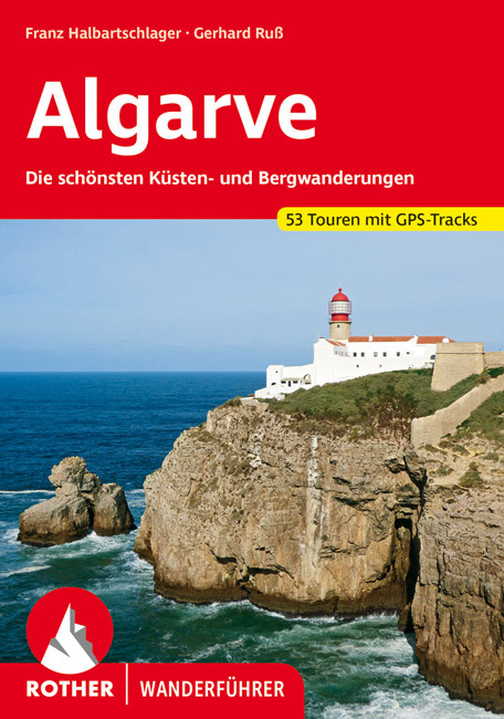
<p> Uitstekende wandelgids met een groot aantal dagtochten in dal en hooggebergte. Met praktische informatie en beperkt kaartmateriaal! Wandelingen in verschillende zwaarte weergegeven in rood/blauw/zwart.</p> <p> <strong style="padding: 0px; margin: 0px; box-sizing: border-box; line-height: inherit; color: rgb(0, 0, 0); font-family: "Helvetica Neue", Helvetica, sans-serif, Arial;">Aanbevolen wandelkaarten bij deze gids:</strong></p> <p> <strong style="padding: 0px; margin: 0px; box-sizing: border-box; line-height: inherit; color: rgb(0, 0, 0); font-family: "Helvetica Neue", Helvetica, sans-serif, Arial;">De west- en zuidwestkust van de Algarve (wandeling 1 t/m 11) + een deel van de Serra de Monchique (wandeling 12 en 13):</strong><br /> <strong style="padding: 0px; margin: 0px; box-sizing: border-box; line-height: inherit; color: rgb(0, 0, 0); font-family: "Helvetica Neue", Helvetica, sans-serif, Arial;"><a href="https://www.dezwerver.nl/r/europa/portugal/Alentejo-Valle-do-Tajo/c/kaarten/wandelkaarten/9789895405220/wandelkaart-parque-natural-do-sudoeste-alentejano-e-costa-vicentina-adventure-maps/">Wandelkaart Parque Natural do Sudoeste Alentejano e Costa Vicentina | Adventure MAPS</a></strong></p> <p> <br /> Die Algarve ist die Sonnenküste Portugals – mit endlosen Sandstränden, klarem Meer und imposanten Klippenküsten. Doch die südwestlichste Ecke des europäischen Kontinents bietet mehr als nur Badeurlaub. Ein hügelreiches, sich nach Norden immer höher auftürmendes und blumenreiches Hinterland, eine eindrucksvolle Felsenküste im Westen und Südwesten, eine beschauliche Flusstallandschaft (Rio Guadiana) im Osten und die weit gestreckte Lagune zwischen Faro und Tavira (Ria Formosa) an der Südküste sind nur einige Beispiele für die große landschaftliche Vielfalt, die den Wanderer hier erwartet.</p> <div> </div> <div> An der gesamten Südküste der Algarve lassen sich reizvolle Küstenwanderungen unternehmen: Von der Südwestspitze Europas über die spektakulären Klippenküsten des Barlavento bis zur Insellandschaft und den weiten Sandstränden im Sotavento bietet dieser Wanderführer zahlreiche Möglichkeiten für kurze oder ausgedehntere Wanderungen. Weitere Touren erschließen die Schönheiten im weniger besuchten Hinterland der Algarve – durch schattige Wälder im Monchique-Gebirge und zu beeindruckenden Flussschleifen im Osten.</div> <div> </div> <div> Der Rother Wanderführer »Algarve« wurde für die vorliegende Auflage vollständig überarbeitet. Übersichtliche Kurzinfos, zuverlässige Wegbeschreibungen, aussagekräftige Höhenprofile und Wanderkärtchen mit eingezeichnetem Tourenverlauf erleichtern die Auswahl und die Orientierung vor Ort. Zu allen Touren stehen zudem GPS-Tracks zum Download bereit.</div>
€18,50
Bekijk product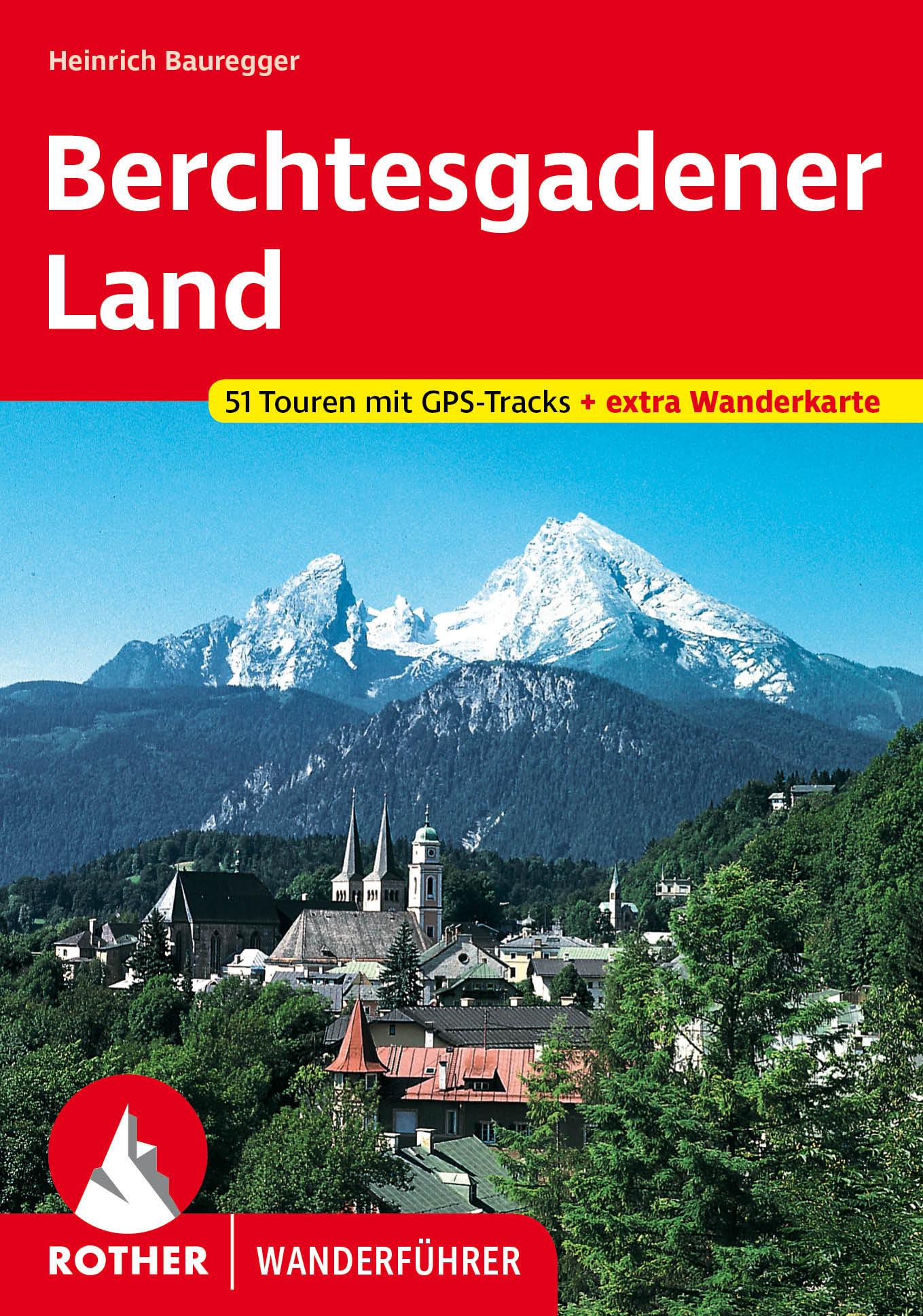
<p> Uitstekende wandelgids met een groot aantal dagtochten in dal en hooggebergte. Met praktische informatie en beperkt kaartmateriaal! Wandelingen in verschillende zwaarte weergegeven in rood/blauw/zwart.</p> <p> 51 Höhenprofile, 51 Wanderkärtchen im Maßstab 1:50.000 und 75.000, zwei Übersichtskarten im Maßstab 1:200.000 und 1:500.000. Mit extra Tourenkarte im Maßstab 1:50.000.</p> <div> Hohe Gipfel, grüne Wiesen, schmucke Ortschaften – das Berchtesgadener Land ist Bayern wie aus dem Bilderbuch. Wer wollte nicht im Angesicht von »König Watzmann« eine Jause auf einer der gemütlichen Hütten genießen oder von den schönsten Aussichtswarten einen Blick auf das türkis-blau schimmernde Wasser des Königssees werfen? Vor beeindruckender Gebirgskulisse lassen sich mit dem Rother Wanderführer Berchtesgadener Land beliebte Almen, Klammen, Berghütten und Bergseen entdecken.</div> <div> </div> <div> Die 51 Touren führen durch die nahezu unberührte Natur des Nationalparks Berchtesgaden und seiner Randgebiete. Dabei kommen ambitionierte Bergwanderer genauso auf ihre Kosten wie Familien mit Kindern. Und wer die Schönheit und Einsamkeit dieser ursprünglichen Gebirgslandschaft in aller Ausführlichkeit erleben möchte, den führt eine 5-Tages-Tour mitten ins stille Herz des Nationalparks.</div> <div> </div> <div> Exakte Wegbeschreibungen, aussagekräftige Höhenprofile, Wanderkärtchen und GPS-Tracks zum Download machen jede Wanderung leicht nachvollziehbar. Für die 14. Auflage wurde der Wanderführer sorgfältig aktualisiert. Die extra Tourenkarte, in die alle 51 Wanderungen eingetragen sind, erleichtert die Orientierung zusätzlich.</div> <div> </div> <div> </div>
€18,50
Bekijk product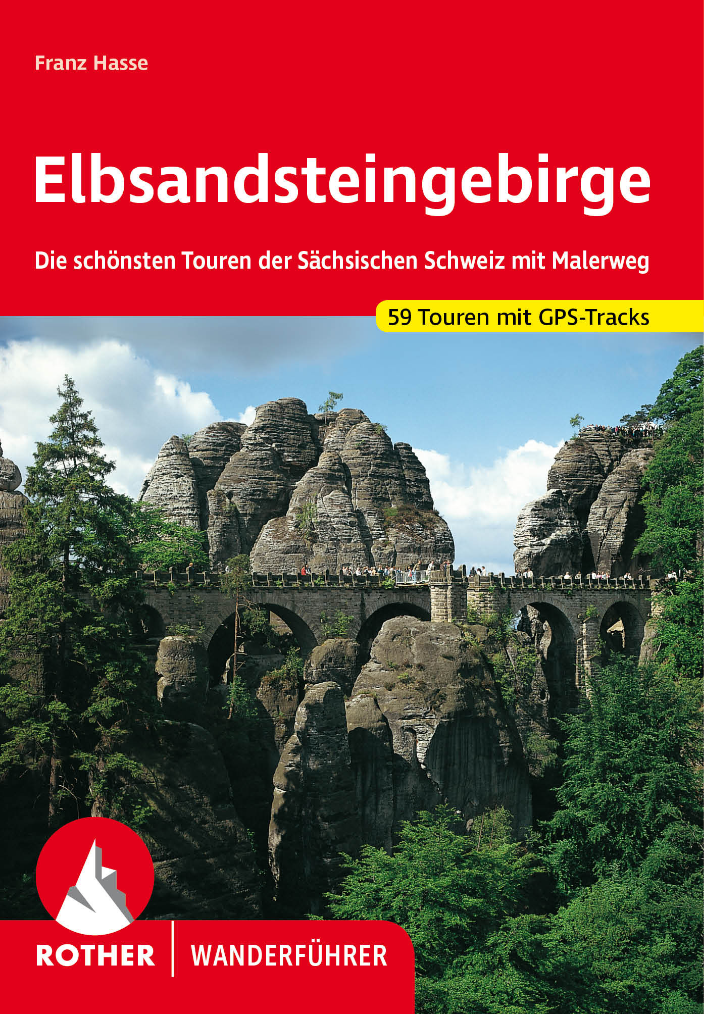
<p> Uitstekende wandelgids met een groot aantal dagtochten in dal en hooggebergte. Met praktische informatie en beperkt kaartmateriaal! Wandelingen in verschillende zwaarte weergegeven in rood/blauw/zwart.</p> <div> <div> Bizarre Felstürme, schroffe Sandsteinwände, tiefe Schluchten und atemberaubende Panoramen – das Elbsandsteingebirge zählt zu den herausragenden Wanderregionen in Deutschland. Die schönsten Touren in der Sächsischen Schweiz, inklusive fünf lohnenswerter Radtouren und dem achttägigen »Malerweg«, stellt dieser Rother Wanderführer vor.</div> <div> </div> <div> Das Tourenangebot reicht von beschaulichen Spaziergängen in den grünen Auenwäldern der Elbe bis zu bestens versicherten Steigen in der bizarren Türmewelt der Sandsteinfelsen. Die vorgestellten Touren verbinden das Wandern in herrlichster Elblandschaft mit dem Besuch von Kulturdenkmälern. Kulturstädte wie Dresden oder Meißen liegen zum Greifen nahe. Und das Schönste: Im Elbsandsteingebirge kann die ganze Familie wandern, es gibt zahlreiche Rast- und Einkehrmöglichkeiten und jede Menge zu erleben – zahlreiche Tipps dafür finden sich im Buch.</div> <div> </div> <div> Jede Tour wird mit einer zuverlässigen Wegbeschreibung, einem Wanderkärtchen mit eingetragenem Routenverlauf und einem aussagekräftigen Höhenprofil vorgestellt. Zudem stehen für alle Touren GPS-Daten zum Download auf der Internetseite des Bergverlag Rother bereit.</div> <div> </div> <div> Der Autor Franz Hasse ist als Einheimischer ein hervorragender Gebietskenner. Er hat die schönsten Wanderungen und so manchen Geheimtipp für diesen beliebten Wanderführer zusammengestellt, der nun bereits in der dreizehnten Auflage vorliegt.</div> </div> <p> </p>
€18,50
Bekijk product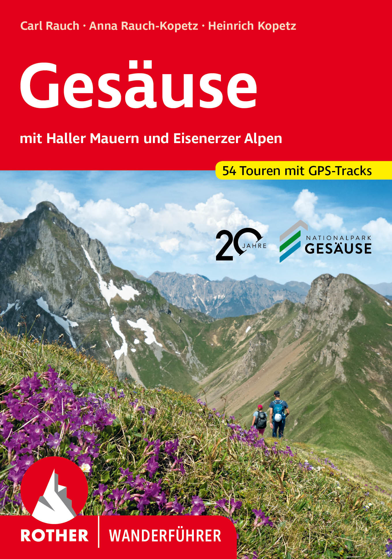
<p> Uitstekende wandelgids met een groot aantal dagtochten in dal en hooggebergte. Met praktische informatie en beperkt kaartmateriaal! Wandelingen in verschillende zwaarte weergegeven in rood/blauw/zwart.</p> <p> Ob sich nun der Name »Gesäuse« tatsächlich vom Sausen und Tosen der ungebändigten Enns-Wasser herleitet oder nicht, sei ganz dahingestellt. Jedenfalls hat der Fluß unweit des steirischen Admont eine im Alpenraum einmalige Gebirgslandschaft geformt: das Gesäuse eben, jene 17 Kilometer lange Schlucht, eng umschlossen von Felsarenen und Tobeln, über der die Berge bis zu 1800 Meter in den Himmel schießen. Liebliche Auenlandschaften und Wasserfälle, Uferwege und in Moosen verschlungene Pfade versprechen ein abwechslungsreiches Kontrastprogramm – nicht nur für Familien mit Kindern – zu den spannenden und anspruchsvollen Bergtouren um Ödstein und Hochtor.<br /> Günter und Luise Auferbauer, die Autoren dieses Rother Wanderführers, kennen ihr Heimatgebirge wie ihre eigene Westentasche. So darf sich der Wanderer auf eine ausgewogene, mit vielen Leckerbissen und Geheimtips angereicherte Lektüre freuen. Darüber hinaus wurden zahlreiche wertvolle Tips für Ausflügler und Feriengäste eingearbeitet, so daß sich der Führer als topaktueller Begleiter für Urlauber und Wanderer präsentiert.<br /> Ergänzt werden die exakten und anregenden Routenbeschreibungen durch farbige Wanderkärtchen mit eingetragenem Routenverlauf und durch stimmungsvolle Farbbilder, die einen hervorragenden Eindruck von jeder Tour vermitteln.</p> <p> </p>
€18,50
Bekijk product