
Beantwoord enkele vragen, en binnen seconden geeft AI je een persoonlijk aankoopadvies op maat.
Beantwoord enkele vragen, en binnen seconden geeft AI je een persoonlijk aankoopadvies op maat.
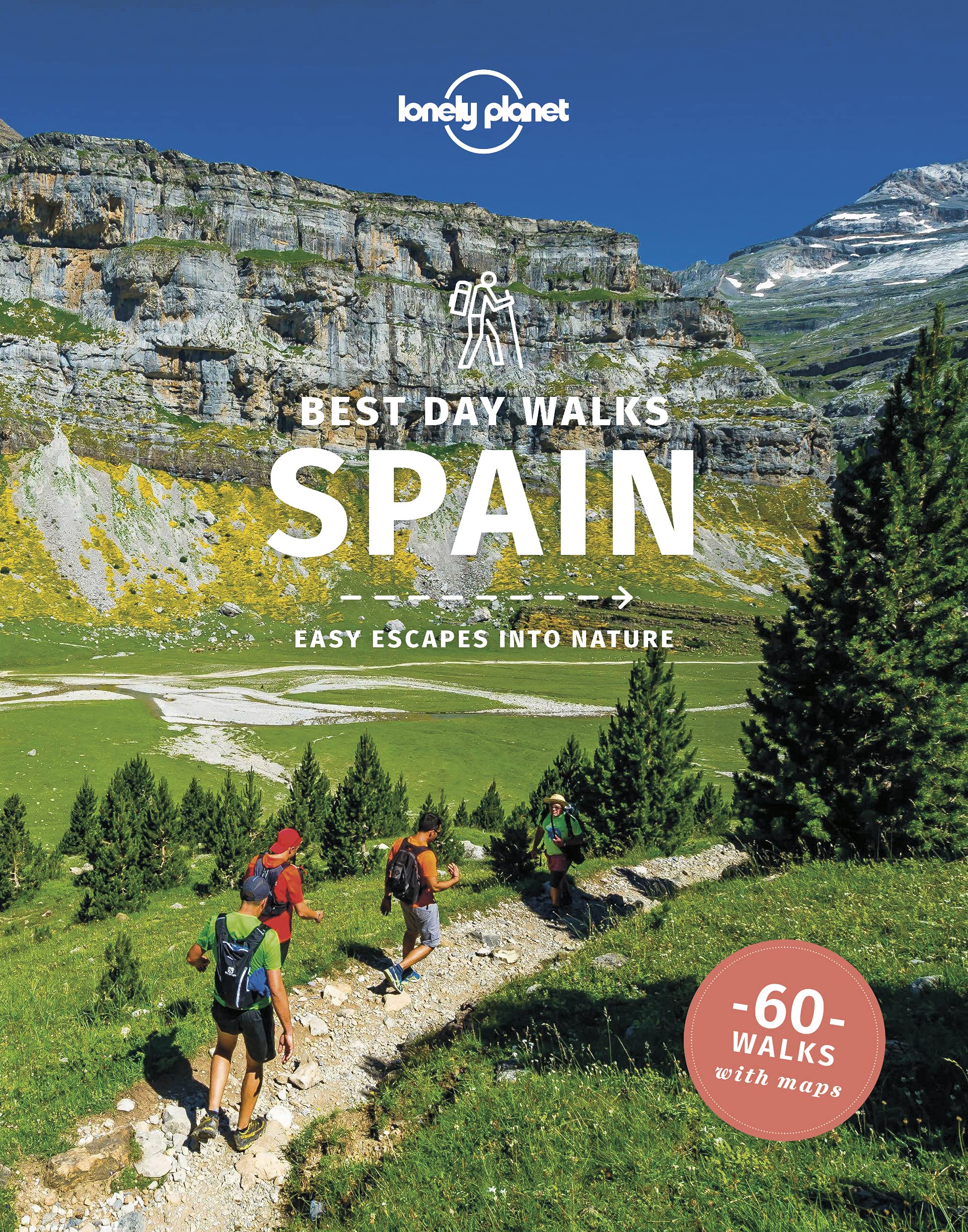
<p> Lonely Planet heeft een nieuwe serie uitgebracht: Best Day Walks in verschillende landen. Het zijn de - door Lonely Planet uitgekozen - mooiste wandelingen verspreid over het land. Goed beschreven, met een schetsmatige kaart erbij ... het werkt heel stimulerend met mooie foto's!</p> <p> <b>Lonely Planet's</b> <b><i>Best Day Walks Spain</i></b>is your passport to 60 easy escapes into nature. Stretch your legs away from the city by picking a walk that works for you, from just a couple of hours to a full day, from easy to hard. Marvel at the Pyrenees, hike along the Mediterranean coast, and experience island walks in Mallorca.</p> <p> Inside<b>Lonely Planet's</b> <b><i>Best Day Walks Spain</i></b><b>Travel Guide:</b></p> <p> <b>Colour</b> maps and images throughout</p> <p> <b>Special features -</b>on Spain's highlights for walkers, kid-friendly walks, accessible trails and what to take<br /> <b>Best for...</b>section helps you plan your trip and select walks that appeal to your interests<br /> <b>Region profiles</b>cover when to go, where to stay, what's on, cultural insights, and local food and drink recommendations to refuel and refresh. Featured regions include:<br /> Pyrenees, Picos & Northern Spain, Galicia, the Mediterranean Coast, Central Spain, Andalucia, Mallorca & Menorca</p> <p> <b>Essential info</b><b>at your fingertips</b>- walk itineraries accompanied by illustrative maps are combined with details about walk duration, distance, terrain, start/end locations and difficulty (classified as easy, easy-moderate, moderate, moderate-hard, or hard)</p> <p> <b>Over 60 maps</b></p> <p> <b>The Perfect Choice:</b> <b>Lonely Planet's</b> <b><i>Best Day Walks Spain</i>,</b>our most comprehensive guide to walking in Spain, is perfect for those planning to explore Spain on foot.</p> <p> </p>
€22,50
Bekijk product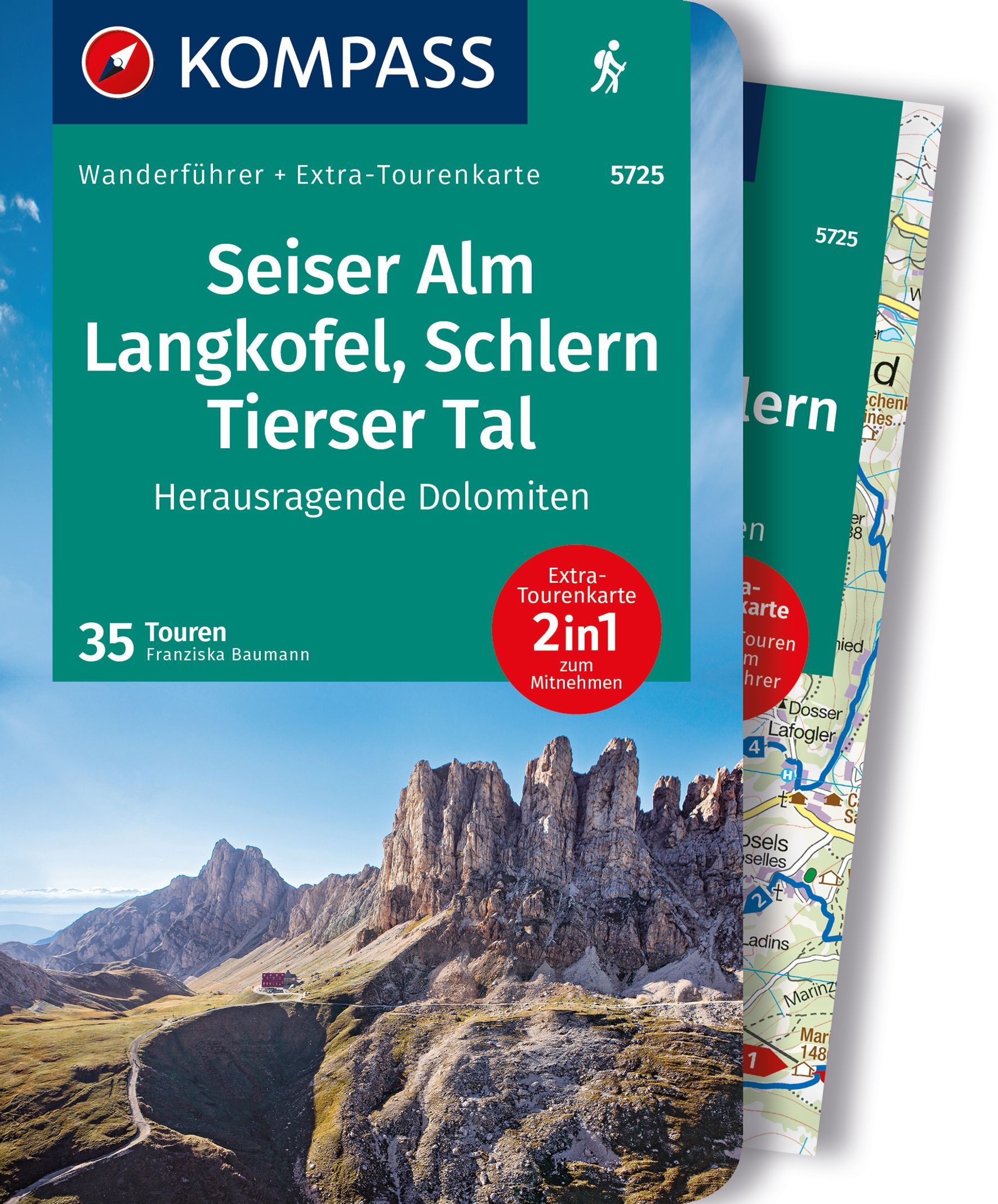
<div> Goede Duitstalige wandelgids met heldere beschrijvingen van de wandeltochten. Met hoogteprofiel, kaartje en de benodigde praktische informatie als bijvoorbeeld de startlocatie met GPS coordinaten. De wandelingen zijn ingedeeld in zwaarte en dan op verschillende kleuren weergegeven. Beschreven worden eenvoudige wandelingen tot pittige (berg)tochten, voor getrainde en ongetrainde wandelaars, een aantal wandelingen zijn geschikt om met kinderen te doen. Belangrijke toevoeging bij de Kompass wandelgidsen is een bijgevoegde losse wandelkaart van het betreffende gebied waarop de wandelingen uit de gids op de kaart heel duidelijk zijn ingetekend. </div> <div> </div> <div> Alle Vorteile des Wanderführers auf einen Blick:</div> <div> . Von KOMPASS-Experten erwanderte Touren</div> <div> . Jede Tour mit Höhenprofil und Kartenausschnitt</div> <div> . Ausflugs- und Übernachtungstipps</div> <div> . Kostenloser Download der GPX-Daten</div> <div> </div> <div> Die Vorteile der Extra-Tourenkarte auf einen Blick:</div> <div> . Unterstützt die Tourenauswahl</div> <div> . Kartografische Gesamtübersicht</div> <div> . Touren können einfach kombiniert werden</div> <div> . Ein Leichtgewicht zum Mitnehmen</div> <div> . Auch als Straßen- und Urlaubskarte verwendbar</div> <div> </div> <div> </div> <div> Destination:</div> <div> . Die Seiser Alm und ihre Umgebung sind ein wahres Wanderparadies. Ein ausgedehntes Wegenetz bietet Touren für jeden Geschmack und jedes Können - von der gemütlichen Genusswanderung bis zur anspruchsvollen Bergroute.</div> <div> </div> <div> . Die Hochfläche der Seiser Alm, Europas größte Hochalm, ist ein Amphitheater, das mit immer neuen Ausblicken überrascht. Schlern, Rosengarten, Lang- und Plattkofel bilden eine faszinierende Felskulisse.</div> <div> </div> <div> . Anspruchsvollere Steige nähern sich den Zacken, Türmen und Wänden oder führen auf die Gipfel. Das unverwechselbare Profil des Schlern ist ein Wahrzeichen Südtirols. Dort oben zu stehen, ist ein einmaliges Erlebnis.</div> <div> </div> <div> . Der Naturpark Schlern-rosengarten ist Südtirols ältester Naturpark. Durch die geologische Vielfalt der Region sind dort viele Tier- und Pflanzenarten beheimatet.</div> <div> </div> <div> . Am Fuß von Seiser Alm und Schlern laden die sonnig gelegenen Urlaubsorte Kastelruth, Seis und Völs zu Wanderungen für die ganze Familie ein - zu geheimnisvollen Burgruinen, durch schattige Wälder und durch Südtiroler Bauernland.</div> <div> </div> <div> . Das leibliche Wohl kommt auf keiner Wanderung zu kurz. Ob gemütliche Alm, schön gelegenes Berggasthaus oder uriger Buschenschank - Spezialitäten aus der Südtiroler Küche machen den Wandergenuss perfekt.</div> <div> </div> <div> Kurzinfo zum Produkt:</div> <div> - Das sportliche Highlight: Eine Zweitagestour über das Schlernplateau bietet ein Kontrastprogramm - genussvolles Wandern über die Seiser Alm, fantastisches Panorama am Schlernhaus und eine spannende Gratüberschreitung ins Tierser Tal.</div> <div> - Das Familien-Highlight: Am Hexenquellenweg auf der Seiser Alm gibt es viel zu entdecken: unterhaltsame Spielstationen, Kunstwerke aus Holz und Stein und eine Schwefelquelle. Eine kurzweilige Runde für die ganze Familie.</div> <div> -Das Genuss-Highlight: Der Oachner Höfeweg führt durch jahrhundertealte Südtiroler Kulturlandschaft und bietet großartige Ausblicke auf die felsige Silhouette des Rosengartens. Am schönsten ist er im Herbst, wenn die Buschenschanke geöffnet sind.</div> <div> - Das persönliche Highlight: Nahblicke auf die senkrecht aufragenden Wände des Langkofels, ein fantastisches Dolomitenpanorama und das Felslabyrinth der "Steinernen Stadt" sind nur einige Höhepunkte der landschaftlich großartigen Runde um Platt- und Langkofel.</div> <div> - Das Kultur-Highlight: Schloss Prösels, Stammburg der Herren von Völs, beeindruckt als gut erhaltene spätgotische Schlossanlage. Sie wird heute für Ausstellungen, Konzerte und Theater genutzt.</div>
€17,50
Bekijk product
<p> The definitive two-way guide to the West Highland Way: both northbound and southbound routes are described in full.<br /> <br /> Real Maps: Full Ordnance Survey Explorer mapping inside (1:25,000). All accommodation is numbered and marked on the maps.<br /> <br /> 17 different itineraries: schedules of 3, 4, 5, 6, 7, 8, 9, 10 and 11 days for hikers and runners. Includes both southbound and northbound itineraries. Difficult calculations of time, distance and altitude gain are done for you.<br /> <br /> Also includes:<br /> - Detailed information on equipment and travelling light<br /> - Everything the trekker needs to know: route, costs, difficulty, weather, travel, and more<br /> - Full accommodation listings: the best inns, B&Bs and hotels<br /> - Detailed section on camping<br /> - Essential info for both self-guided and guided trekkers<br /> - Information on geology, history, plants and wildlife<br /> - Numbered waypoints linking the Real Maps to our clear descriptions<br /> <br /> The West Highland Way, which is one of 'Scotland's Great Trails', travels 96 miles through sublime scenery, from the outskirts of Glasgow to Fort William. In between, there are countless magnificent mountains, exquisite glens, shimmering lochs and seemingly endless miles of purple heather to experience. The trekker negotiates this wonderfully unpopulated terrain on a meticulously waymarked series of paths and tracks, many of which are old military roads or drovers' paths, built many centuries ago. In this part of the Highlands, you are far away from the region's urban centers. Occasionally, you will meet a road or pass through a small village or hamlet (with little more than a local pub and a few places to stay) but otherwise, the experience is one of tranquility. This is the Scottish Highlands at their best and it will be an adventure that you will never forget.</p>
€19,50
Bekijk product
<p> Fraaie, goed verzorgde wandelgidsjes met 28 wandelingen van max. een dag, (beginnend bij korte, eindigend bij langere wandelingen). Weergegeven op duidelijke topografische kaartjes (1:25.000). Bevat verder wetenswaardigheden en praktische informatie voor onderweg.</p> <p> In this Pathfinder guide clear and easy to follow directions are accompanied by detailed 1:25,000 scale maps from Ordnance Survey and specially commissioned photographs. With 28 colour-coded routes to choose from, all tried and tested by seasoned walkers and varying from extended strolls to exhilarating hikes, there is a walk to suit all situations. The guide introduces you to the area and highlights the most scenic walks. Details are included for useful organisations, refreshment stops and places to leave your car. GPS waypoints are included.</p>
€18,50
Bekijk product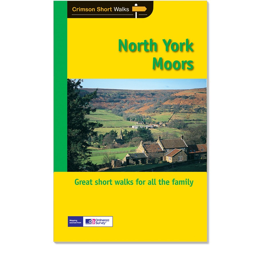
<div> Get lost in 28 beautiful walks exploring the North York Moors with the OS Pathfinder Guidebooks, graded by length and ranging from 3.5 to 11 miles.</div> <div> </div> <div> Make the most out of your next trip to the York Moors! Some of the more popular walks feature in this guide are Robin Hood's Bay, Rivaulx Abbey, the River Esk valley, and the Cook Monument. Each walk includes easy-to-follow route directions and accompanied by large-scale Ordnance Survey route maps, GPS waypoints, and captivating photographs.</div> <div> </div> <div> Walks in this guide include routes across wild and remote moorland, such as Ingleby Moor, Westerdale Moor, and Ainthorpe Rigg are contrasted with coastal and clifftop walks around Runswick Bay and Staithes, Whitby, and Saltwick bay and Ravenscar.</div> <div> </div> <div> This is one of a series of books with great walking routes covering the most popular and scenic areas of Britain.</div>
€18,50
Bekijk product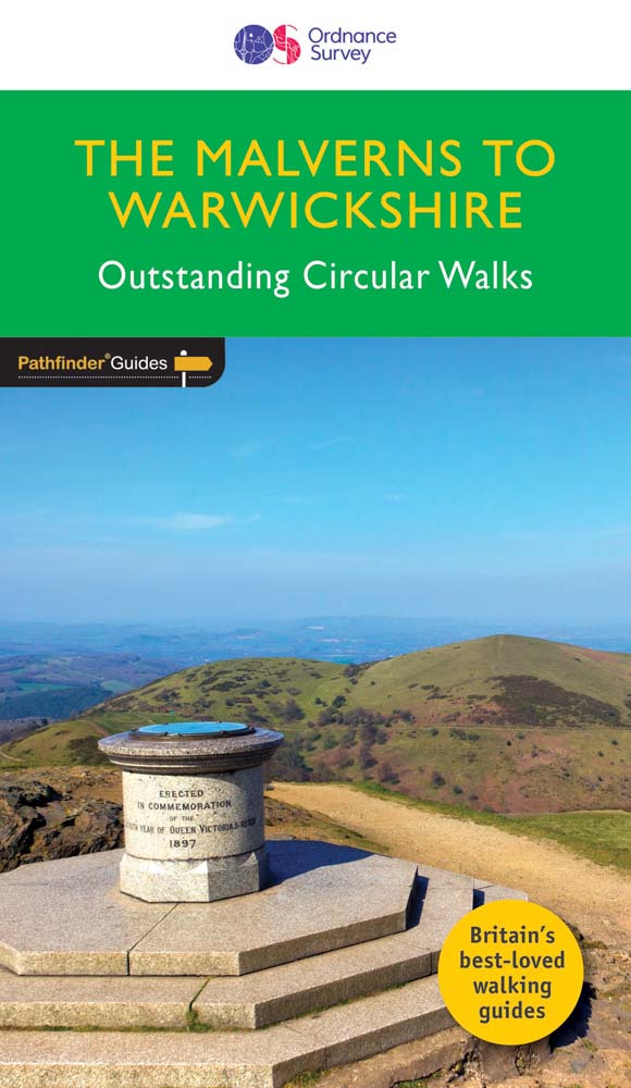
<div> Discover 28 beautiful walks across The Malverns to Warwickshire with the OS Pathfinder Guidebooks, graded by length and ranging from 3 to 9 miles - ideal for both holidaymakers and locals.</div> <div> </div> <div> The area covered by this guide is characterised by gently rolling hills, verdant river valleys, wooded tracts, small market towns, and an abundance of attractive villages with thatched cottages, medieval churches, and fine old pubs.</div> <div> </div> <div> Each walk includes a detailed description, an OS map, GPS waypoints and notes of key features and things to see. Routes include the Warwickshire Beacon, the oddly-named Lickey Hills, and Charlecote Park - allegedly where Shakespeare was once caught poaching.</div> <div> </div> <div> Printed with weather-resistant covers featuring durable rounded corners, they are the perfect companion for country walking throughout Britain.</div>
€18,50
Bekijk product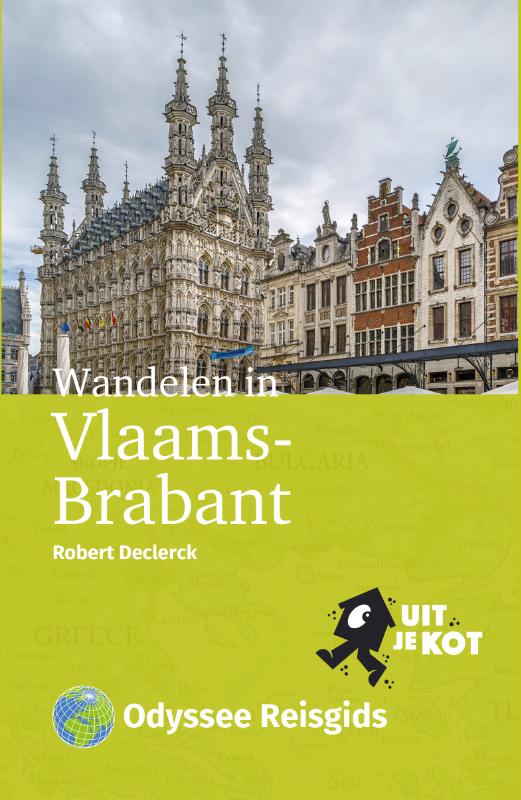
<p> Tien wandelingen in Vlaams-Brabantse steden Na de gidsen Wandelen in Oost-Vlaanderen en Wandelen in Limburg neemt Robert Declerck je mee naar de jongste provincie van België: Vlaams-Brabant. Hij wandelt in steden en stadjes in Hageland, Haspengouw en Pajottenland. Alle routes hebben een lengte van ongeveer vijf kilometer.</p> <p> Onderweg loop je langs bijzondere plekken: van onverwachte bezienswaardigheden tot groene (stads)parken. De auteur heeft een scherp oog voor details waaraan je gemakkelijk voorbij loopt. Een van de wandelingen brengt je naar het kleine Galmaarden, de parel van Pajottenland. Deze Odyssee-wandelgids biedt: Gedetailleerde routebeschrijvingen en kaarten Verrassende tussenstops Startpunten bij het station Leuke uit-je-kot tips voor onderweg</p>
€18,50
Bekijk product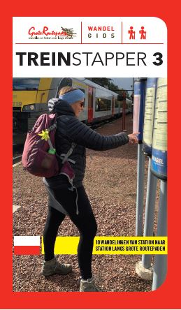
<div> Wordt het een dagje uitwaaien aan zee of duik je in het verleden van de Westhoek? Laat je bekoren door de Vlaamse Ardennen in het voorjaar of door de bloesems en het rijpend fruit in Haspengouw. Wandel je liever door het weidse, groene Hageland of zoek je de stilte van de Antwerpse Kempen op? Of combineer je Dijle en Zenne met een passage door het historisch centrum van Mechelen?</div> <div> </div> <div> Wandelgids Treinstapper 3 bundelt 10 treinstappers: dagtochten van station naar station langs GR-paden. Met de verkortingsmogelijkheden zijn de wandelingen ook haalbaar voor gezinnen met kinderen. Naast routebeschrijvingen in twee richtingen vind je informatie terug over het openbaar vervoer en krijg je leuke weetjes over de streek voorgeschoteld. De gedetailleerde kaarten op schaal 1:25.000 tonen treinstations en bushaltes, horeca, winkels en bezienswaardigheden.</div> <div> </div> <div> De geselecteerde routes zijn:</div> <div> </div> <ol> <li> Blankenberge – Oostende</li> <li> Komen – Ieper</li> <li> Ronse – Oudenaarde</li> <li> Mollem – Aalst</li> <li> Zichem – Aarschot</li> <li> Hever – Eppegem</li> <li> Essen – Heide</li> <li> Geel – Mol</li> <li> Diepenbeek – Bilzen</li> <li> Landen – Sint-Truiden</li> </ol>
€22,50
Bekijk product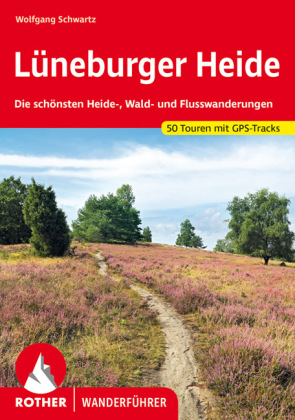
<div> Violett blühende Heidelandschaften, reetgedeckte Häuser, Bienenzäune und die berühmten Heidschnucken - in der Lüneburger Heide lässt es sich herrlich wandern! Die Lüneburger Heide ist die größte zusammenhängende Heidefläche in ganz Europa und - mit Gründung im Jahr 1921 - das erste Naturschutzgebiet Deutschlands. Mit den 50 Wanderungen in dem Rother Wanderführer »Lüneburger Heide« lässt sich diese einzigartige Landschaft höchst abwechslungsreich erkunden.</div> <div> </div> <div> Wanderer erwartet eine ausgezeichnete Tourenauswahl: Schöne Wege und Pfade führen durch die Heidelandschaften, durch Wälder und entlang von Flüssen. Sitzbänke laden zu ausgedehnten Pausen ein und in Gasthäusern und Cafés lässt es sich gemütlich einkehren. Für Abwechslung sorgt auch die jahrhundertealte Heidebauernkultur mit ihrer Imkerei, den weidenden Schafen und hübschen Fachwerkhäusern - da gibt es viel zu entdecken.</div> <div> </div> <div> Autor Wolfgang Schwartz stellt die Wanderungen durch die Lüneburger Heide mit viel Liebe zum Detail vor. Informationen zu öffentlichen Verkehrsmitteln, mit denen sämtliche Touren erreichbar sind, und einladenden Gasthöfen fehlen ebenso wenig wie Tipps zu Sehenswürdigkeiten. Detaillierte Routenbeschreibungen, Kartenausschnitte mit eingezeichnetem Wegverlauf und aussagekräftige Streckenprofile stellen die Wanderungen zuverlässig vor. Ergänzend stehen geprüfte GPS-Tracks zum Download bereit.</div> <div> </div> <div> Der Rother Wanderführer »Lüneburger Heide« ist ein Muss für alle, die die beliebte Region zwischen Hamburg, Bremen und Hannover zu Fuß erkunden wollen!</div> <p> </p>
€19,50
Bekijk product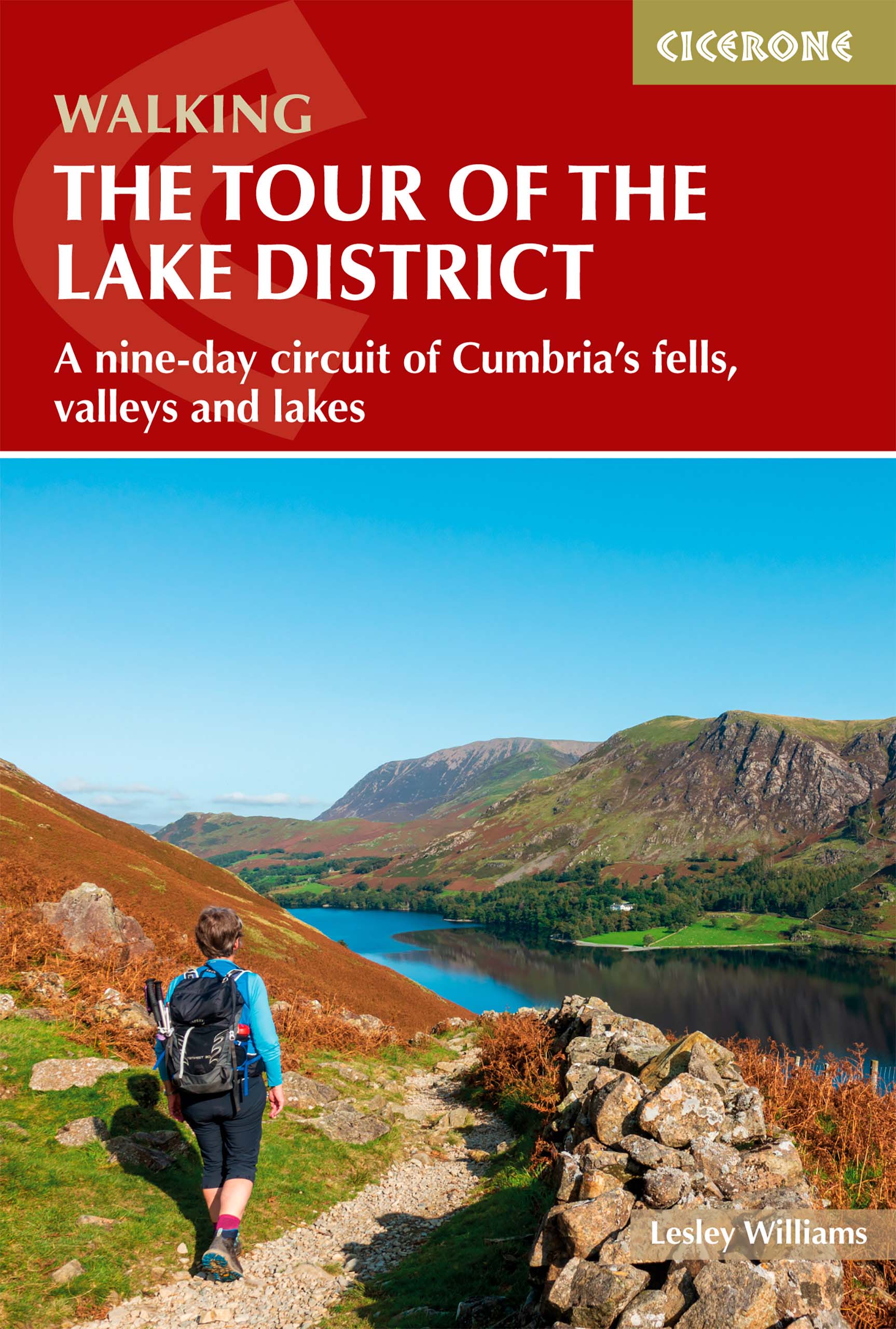
<p> Engelstalige beschrijving van de mooiste wandeltocht in het Lake district. De gids voldoet aan alle verwachtingen die je kunt hebben, het enige dat je mist is een overzichtskaart. Inclusief gidsje met routekaarten van 1:25000</p> <div> The Lake District National Park is England's most popular mountain region and is designated as a UNESCO World Heritage site. Suitable for most reasonably fit hillwalkers, the 145km (90 mile) Tour of the Lake District takes in the best of this beautiful region in a circular tour. The route is presented in nine stages, plus an optional 'prologue' stage from Windermere station to the start-point in Ambleside, and can be compressed into one week or extended over two weeks, giving time to visit many attractions on the way.</div> <div> </div> <div> In addition to the main (non-waymarked) route, which links the main towns and valleys of the national park, five interchangeable high-level stages are also offered, enabling you to visit some of the region's most celebrated high peaks - including Coniston Old Man, Scafell Pike, Great Gable and Helvellyn - should you so wish. Each stage includes summary statistics and clear route description illustrated with OS mapping and an elevation profile. There are notes on local points of interest and a wealth of information to help you plan your tour, covering public transport, accommodation and kit, plus accommodation listings and a facilities table.</div> <div> </div> <div> The Tour showcases the magnificent landscapes of the region, from mountain vistas to idyllic lakeshore scenery. There are lakes, rivers and waterfalls, characterful towns and villages, remote valleys, high fells and fascinating historical features including a Neolithic stone circle, packhorse bridges and properties that once belonged to Beatrix Potter and William Wordsworth. There are a wide range of accommodation options to suit all budgets and opportunities to sample delicious local produce. The Tour of the Lake District is an ideal way to discover all the region has to offer and is sure to generate lots of memorable experiences.</div>
€20,95
Bekijk product