
Beantwoord enkele vragen, en binnen seconden geeft AI je een persoonlijk aankoopadvies op maat.
Beantwoord enkele vragen, en binnen seconden geeft AI je een persoonlijk aankoopadvies op maat.

<p> Guidebook describing 30 walks in Snowdonia, Wales. Routes are mostly low level and on clear paths and showcase the region's beautiful scenery and rich history and culture. Part of a 2-volume set, this southern volume includes Trawsfynydd, Bala, Dolgellau, Machynlleth, the Harlech Coast and the valleys of the Mawddach and Dyfi.</p> <div> Through 30 day walks ranging from 3km to 18km, this guide offers opportunities for walkers of all abilities to explore the lowlands, moorland and estuaries of Snowdonia National Park. The second of two volumes to low-level and easy walking in Snowdonia, this guide covers the southern region between Llan Ffestiniog and Machynlleth. Other centres include coastal towns of Harlech, Barmouth and Aberdyfi, and lakeside settlements of Trawsfynydd and Y Bala.</div> <div> </div> <div> Famous for its northern mountains, the Snowdonia National Park also features an expansive coastline of sandy beaches and wildlife-rich estuaries. Inland, the landscape showcases mossy-banked rivers, gorges and thundering waterfalls in ancient broadleaved woodlands, while tranquil valleys and moorlands dotted with ruined castles, mines and forts provide panoramic views of surrounding mountains and lakes.</div> <div> </div> <div> Each walk features in-depth route description and 1:25,000 or 1:50,000 OS mapping, alongside a wealth of insights into the history, geology and wildlife of the area. The guide supplies what3words addresses for start and finish points and postcodes for car parks, as well as refreshments and facilities available on each route and an appendix of useful contacts.</div>
€13,95
Bekijk product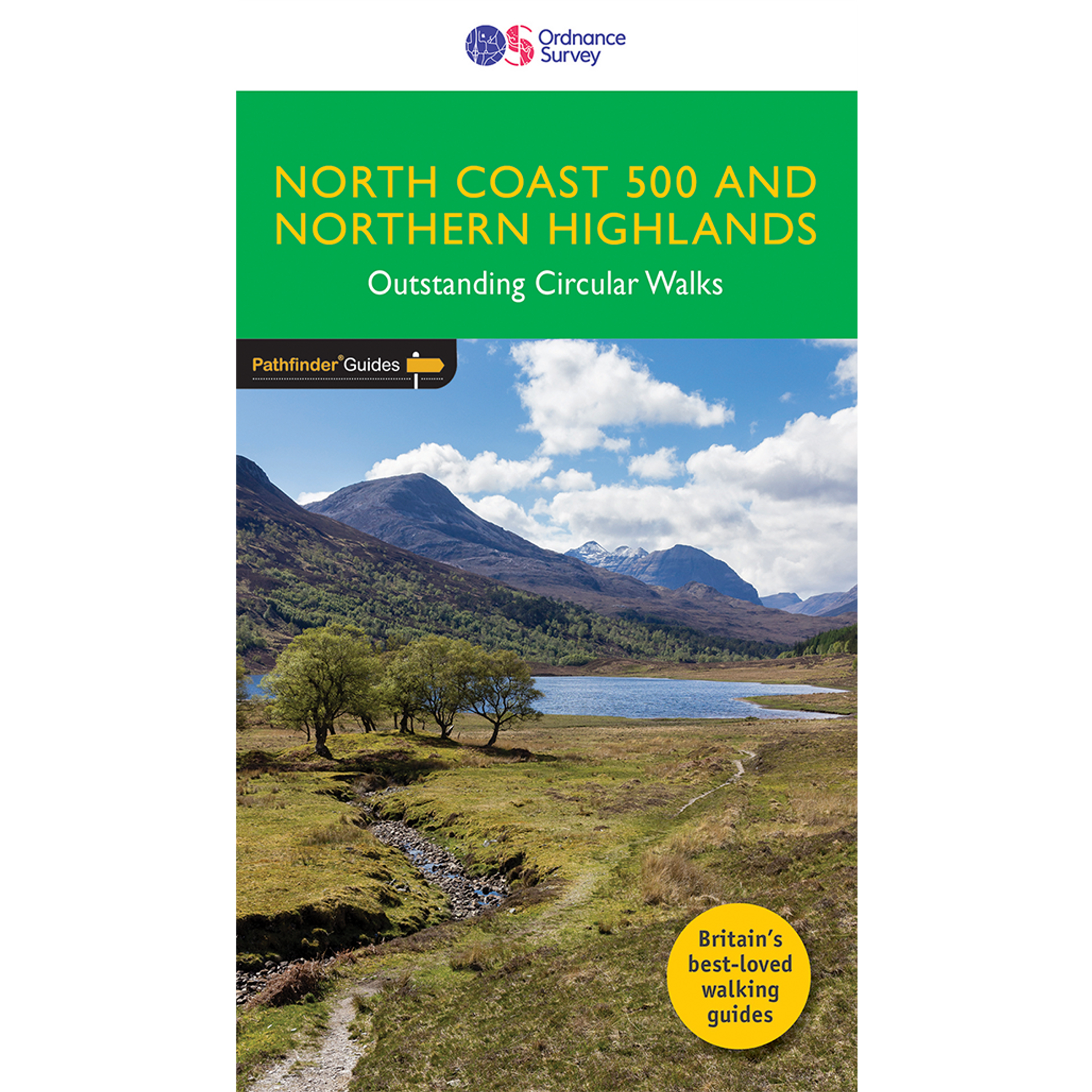
<div> Enhance your North Coast 500 tour with the only walking guidebook featuring routes based on or accessible from Scotland’s ultimate road trip. Discover Britain’s remotest sandy beaches, Scotland’s most northerly munro, some of the oldest rocks on Earth and more with 28 breathtaking walks accessed from the North Coast 500 as well as 32 unmissable stop-off-and-stroll recommendations.</div> <div> </div> <div> Featured North Coast 500 and Northern Highlands walks include:</div> <div> </div> <div> - Circle Loch Coulin where Beinn Eighe and Liathach are reflected in the still waters</div> <div> - Wander the astounding landscape of Knockan Crag, where some of the oldest rocks on Earth can be seen</div> <div> - Climb Ben Hope, Scotland’s most northerly munro, towering above the Flow Country</div> <div> - See the waterfalls and rocks walls of the Big Burn as you ascend Ben Bhraggie for views over the Dornoch Firth</div> <div> - Explore the landscape and history of the Applecross peninsula with sublime views of Raasay</div> <div> - Take a moorland and clifftop route to the vast golden sands of Sandwood Bay</div> <div> - Follow meadow paths to Castle Varrich where it overlooks the stunning Kyle of Tongue</div> <div> - Discover the view from the Fyrish Monument, a panorama of the Cromarty Firth and across the Black Isle to the Moray Firth</div> <div> - Escape the tourists on a spectacular cliff walk at Duncansby Head, the extreme north-east tip of Scotland</div> <div> </div> <div> The perfect companion to your North Coast 500 trip:</div> <div> </div> <div> - 28 stunning Pathfinder walks accessed from the North Coast 500</div> <div> - 32 not-to-be-missed spots to stop off and stroll as you drive the Northern Highlands</div> <div> - Driving distances around the North Coast 500, plus cross-country distances from Inverness for leaving or rejoining the North Coast 500</div> <div> - Walks are sequentially numbered taking a clockwise circuit around the North Coast 500</div> <div> - Route planning and itinerary options plus public transport access for walkers</div> <div> - Walks are graded by length and difficulty ensuring a range of routes suitable for walkers of varying experience and mobility</div> <div> - Includes OS Explorer 1:25 000 scale map extracts for every route (4cm to 1km or 2½ inches to one mile)</div> <div> - Discover GPS waypoints, parking information and detailed route descriptions for foolproof navigation</div> <div> - Part of the Pathfinder series, the definitive pocket book guide to Great Britain’s great outdoors</div> <div> - Enhances your walk with information on rare wildlife, natural habitats and points of historical interest</div> <div> </div> <div> About OS Pathfinder Series</div> <div> </div> <div> - 80 Pathfinder titles including 2,000 routes across England, Wales and Scotland</div> <div> - Explore a wealth of walks, from Land’s End to the Lleyn Peninsula, Shetland to Southwold, with the Pathfinder Series</div> <div> - Titles include OS Pathfinder Guides, OS Short Walks Guides, OS City Walks Guides</div> <div> Read less</div>
€18,50
Bekijk product
<p> Een gids voor 40 geweldige bergwandelingen en klautertochten in Snowdonia. De inspirerende routes in dit groter formaat boek bevinden zich over het hele Snowdonia Nationaal Park en zijn onderverdeeld in 8 geografische regio's: Snowdon en Moel Eilio, de Glyderau, de Carneddau, Eifionydd, Siabod en de Moelwynion, Rhin</p> <p> A guidebook to 40 great mountain walks and scrambles in Snowdonia. The inspirational routes in this larger format book range right across the Snowdonia National Park and are divided into 8 geographical regions: Snowdon and Moel Eilio, the Glyderau, the Carneddau, Eifionydd, Siabod and the Moelwynion, Rhinogydd (the Harlech Dome), Migneint and the Arans and Cadair Idris and the Tarrens.</p> <div> All routes are graded, from moderate to strenuous, and illustrated with Harvey map extracts, topo diagrams by Mark Richards and lots of stunning photographs. Some routes include mild scrambling or long days in rugged country, and many can be enjoyed all year round. The walks have been chosen to encourage you to try something new in this much-loved region, while at the same time offering clear descriptions of classic routes for those new to Snowdonia.</div>
€26,50
Bekijk product
<div> Wandeling langs de Thames dwars door de stad Londen met duidelijke kaartjes.</div> <div> </div> <div> Fully revised and updated. This comprehensive guide to the London section of the Thames Path Trail Guide covers the route from Hampton Court in the east to the Thames Barrier in the west, with an extension into Crayford Ness. From the Mesolithic Period timber piles near Vauxhall Bridge to the innovative Shard skyscraper at London Bridge, the long and remarkable history of London is revealed.</div> <div> </div> <div> Clapham covers all the folklore from the famous frost fairs to the much-lamented beach near Tower Bridge, not forgetting the poignant recent visit of a large whale to the centre of London. The Thames winds all the way through London's history and culture, from Henry VIII's Hampton Court to the chequered fate of the Dome/O2. Accompanied by easy-to-read maps and colour photography, the London resident as much as the visiting tourist will find in this guide something new every step of the way.</div>
€20,95
Bekijk product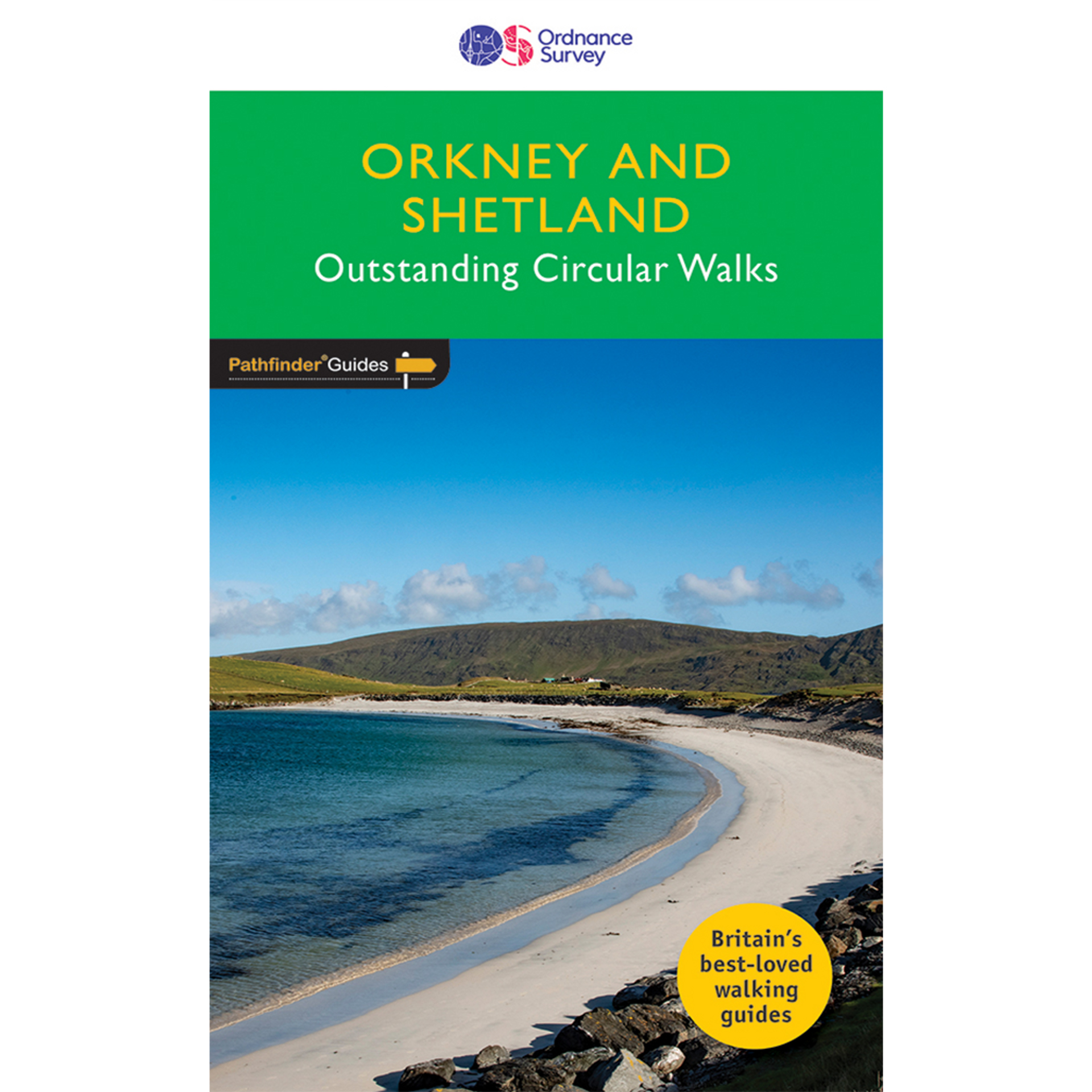
<p> Wandelgids van een deel van Engeland. Deze gids bevat 28 dagwandelingen, variërend van korte tochten tot pittige dagtochten. De bijbehorende kaarten zijn uitstekend: men heeft de topografische kaarten van Ordnance Survey gebruikt waarop de route is ingetekend. Daarnaast praktische informatie over de wandeling en wat beschrijvingen van het gebied.</p> <div> 28 outstanding walks – 23 circular and five there-and-back routes visiting eleven islands across both archipelagos. The size and nature of the islands lend themselves best to short and half-day walks where unhurried and free-range walking is encouraged and the endless distractions of scenery, seabirds, wildflowers and sea watching are best appreciated and enjoyed at a relaxed pace.</div> <div> </div> <div> In Orkney, the first walk is a short stroll around Hoxa Head with its extensive views across Scapa Flow and subsequent routes go on to explore more widely over Mainland Orkney and take in the islands of Hoy, Rousay and South Ronaldsay, concluding with a ramble along the breathtaking clifftops of Yesnaby to enjoy the Yesnaby Castle and North Gaulton sea stacks, in addition to the fine 2,500-year-old Broch of Borwick. Among the other walks on Orkney you are guided round the sights of Kirkwall, taken to prehistoric Mid Howe Chambered Cairn, lead across a tidal causeway to Birsay, and to a good whale watching point overlooking the Pentland Firth from Cantick Head.</div> <div> In Shetland, the first walk sets out from Sandsayre jetty to the tiny island of Mousa, renowned for two outstanding marvels – a very distinctive Iron Age broch and an RSPB reserve of international importance for petrels and other seabirds. Walks range across Shetland from wild and remote Hermaness, on the far northern tip of Unst, down to Sumburgh Head, its most southerly point, where in addition to visiting the lighthouse, the itinerary also includes the historically fascinating multi-period settlement complex of Jarlshof. In between, you can walk on the extensive silver sands of Banna Minn and St Ninian’s Isle, enjoy cultural heritage in Lerwick and Scalloway, and experience the rich natural beauty and airy peacefulness of Fethaland and the Sands of Breckon.</div> <div> </div> <div> 28 outstanding walks across Orkney and Shetland: walks range from 1¾ to 6¾ miles with clear, large scale Ordnance Survey route maps, GPS waypoints, where to park, and places of interest en route. These all-new routes have been researched and written by expert outdoor writer Terry Marsh and showcase beautiful photography of scenes from the walks. Pathfinder® Guides are Britain’s best-loved walking guides. Printed with weather-resistant covers featuring durable rounded corners, they are the perfect companion for country walking throughout Britain. With 80 titles in the series, and 2000 routes to choose from, a wealth of walks is available throughout England, Scotland and Wales from Land's End to Unst and the Lleyn Peninsula to Southwold</div>
€18,50
Bekijk product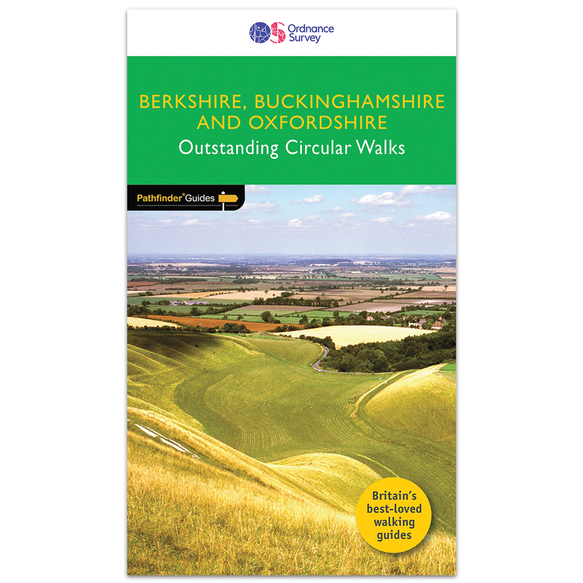
<p> Wandelgids van een deel van Engeland. Deze gids bevat 28 dagwandelingen, variërend van korte tochten tot pittige dagtochten. De bijbehorende kaarten zijn uitstekend: men heeft de topografische kaarten van Ordnance Survey gebruikt waarop de route is ingetekend. Daarnaast praktische informatie over de wandeling en wat beschrijvingen van het gebied.</p> <div> This all-new Pathfinder® Guide covering the ceremonial counties of Berkshire, Buckinghamshire and Oxfordshire features 28 outstanding circular walks across all three counties, offering more wonderful Pathfinder® routes in the south-central Midlands between the Cotswolds (PF 6 Cotswolds) and the Chilterns (PF 25 Thames Valley and Chilterns). In this welcome addition to the Pathfinder® series, walks range from Banbury in the north to Newbury in the south and, west to east, from Milton-under-Wychwood to Virginia Water. Follow brand-new rambles exploring the Chilterns, the Thames Valley, the North Wessex and Berkshire Downs, the Kennet valley, the Oxfordshire Cotswolds and over the Oxfordshire Plain.</div> <div> </div> <div> Walks are set out with the shorter routes at the front of the book, generally progressing through half-day walks to the longer distance outings near the end of the guide. Walks are professionally authored and depicted with GPS waypoints, Ordnance Survey maps and beautiful photography.</div>
€18,50
Bekijk product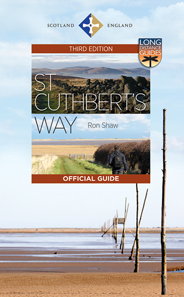
<p> This 100k (60 mile) walk was opened in 1996 and has rapidly increased in popularity, with thousands of walkers walking all or parts of it every year. Visiting a number of places closely associated with St Cuthbert's life, the journey is full of historical interest and natural beauty. It can be tackled in its entirety, or sections can be walked separately, making an ideal day or weekend outing. Today's pilgrims travel from Melrose in the Scottish Borders to the Holy Island causeway at Beal. In the right conditions, the path across the sand here makes a superb finale to the walk.<br /> <br /> This completely revised edition of the Official Guide adds an entirely new full-colour folding map, prepared by leading Scottish cartographer Nicolson Maps for this edition, and packaged with the Guide in a weatherproof wallet. It is illustrated in full colour with photographs throughout and new maps (also by Nicolson Maps) at the opening of each section. Full of information about the historical and natural features of the route, the Guide also covers appropriate equipment for walkers, way-marking, car parking, accommodation and the Country Code. After the walk, the Guide makes a wonderful souvenir of one of Britain's most evocative long-distance ways.</p>
€23,95
Bekijk product
<div> Let op! Franstalige gids!</div> <div> </div> <div> Topografische gids voor grensoverschrijdende wandeltocht.</div> <div> </div> <div> Escapardenne Eisleck - Eislek Trail loopt over 104 km van Kautenbach naar La-Roche-en-Ardenne door een schitterend deel van de Ardennen. Een nieuw langeafstandspad dat het Groothertogdom Luxemburg verbindt met de Waalse provincie Luxemburg. Grensoverschrijdend dus en niet alleen letterlijk! Dit is het eerste wandelpad in de Benelux dat werd ontworpen volgens de strenge Europese normen voor een 'Leading Quality Trail'. Terecht werd EscapArdenne Eisléck Trail dan ook bekroond met dat Europese label bij de opening eind 2012. Als wandelaar krijg je een continue afwisseling van wilde Ardennenlandschappen, oude karakterdorpen, prachtige panorama's en stille natuurgebieden voorgeschoteld</div> <div> </div> <div> Kautenbach - Munshausen - Clervaux - Asselborn - Houffalize - Nadrin - La Roche en Ardenne</div>
€19,95
Bekijk product
<p> Deventer is vooral bekend van het Dickensfestival, de Boekenmarkt en Deventer op Stelten, maar ook buiten de middeleeuwse binnenstad valt veel te beleven. Op haar ontdekkingstochten zwierf de ervaren routemaker Marycke Janne Naber langs de IJssel en door parken en mooie landgoederen rondom Deventer en Twello. Marycke leidt je langs oude begraafplaatsen, al dan niet voormalige kerken en ziekenhuizen en het stadion van Go Ahead Eagles. Het oorlogsverleden van Deventer komt aan bod en een aantal wandelingen herinneren aan de bloeiende industrie vanaf het eind van de 19e eeuw. Ook de gerenoveerde arbeiderswijken en de moderne architectuur, met name in het Havenkwartier, zijn de moeite waard.</p> <p> Een en ander heeft geleid tot tien fraaie routes, waarvan twee over de grens met Gelderland lopen. De 10 tot 15 km lange rondwandelingen met voldoende horeca onderweg starten alle bij station Deventer of Deventer Colmschate. Een duidelijke routebeschrijving, een routekaartje en heel veel informatie over de bezienswaardigheden die je tegenkomt maken je wegwijs in en rond de oude Hanzestad.</p>
€17,95
Bekijk product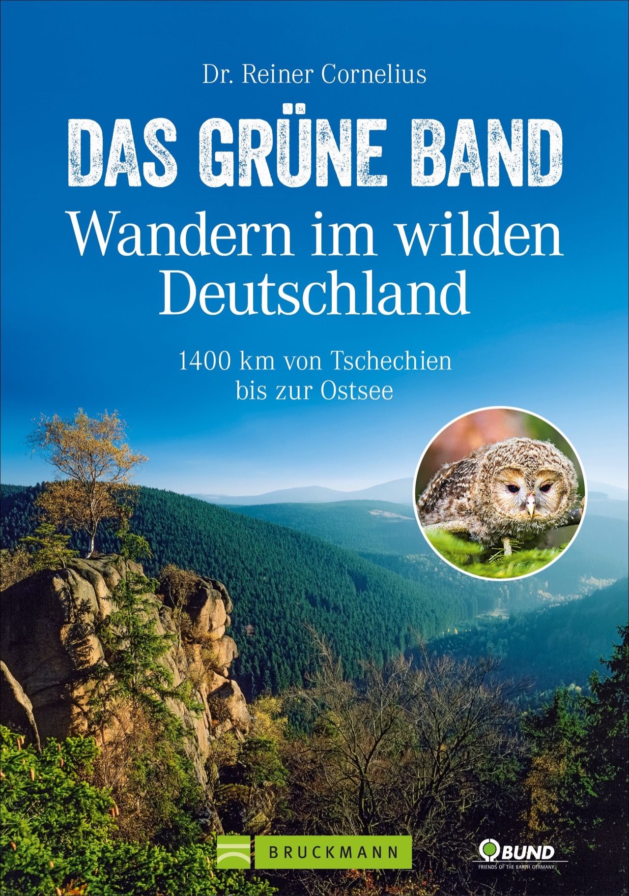
<p> Auf den Spuren der Vergangenheit wandeln und die unberührte Natur entlang des Grünen Bands genießen - Der ideale Begleiter für Ihr nächstes Abenteuer! Wandern, wo einst Geschichte geschrieben wurde: Die Landschaft entlang der ehemaligen innerdeutschen Grenze gestaltet sich auch so lange Zeit nach dem Mauerfall als Erlebnis ersten Ranges.</p> <p> Durch wilde Wälder streifen, über bunte Wiesen schlendern, von felsigen Höhen weit übers Land blicken: 61 Etappen führen auf Patrouillenwegen und alten Grenzerpfaden über das 1400 Kilometer lange Grüne Band Deutschland, den Natur gewordenen Grenzstreifen. Mit ausführlichen Wegbeschreibungen, wissenswerten Infos, Detailkarten und GPS-Tracks zum Download</p>
€24,95
Bekijk product