
Beantwoord enkele vragen, en binnen seconden geeft AI je een persoonlijk aankoopadvies op maat.
Beantwoord enkele vragen, en binnen seconden geeft AI je een persoonlijk aankoopadvies op maat.
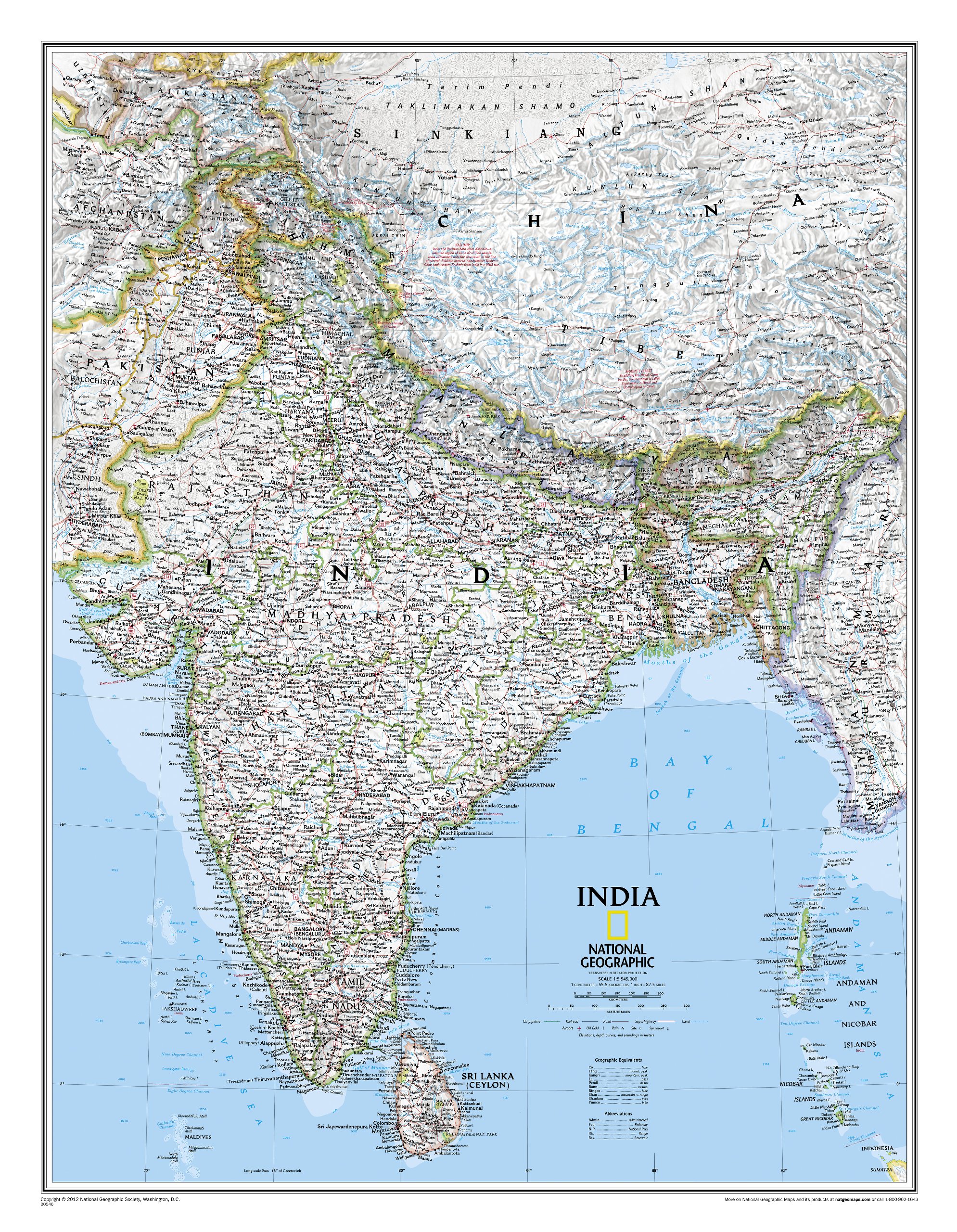
See India as only National Geographic can depict it. This new reference map is one of the most detailed and comprehensive ever published for India and southern Asia. It includes India, Sri Lanka, Nepal, Bangladesh, Bhutan, Tajikistan, and portions of China, Pakistan, Afghanistan, and Myanmar. The India map is punctuated with thousands of place names, and embellished with shaded relief which highlights the region's dramatic topography in such places as the Tibetan Plateau and the Himalaya.
€31,95
Bekijk product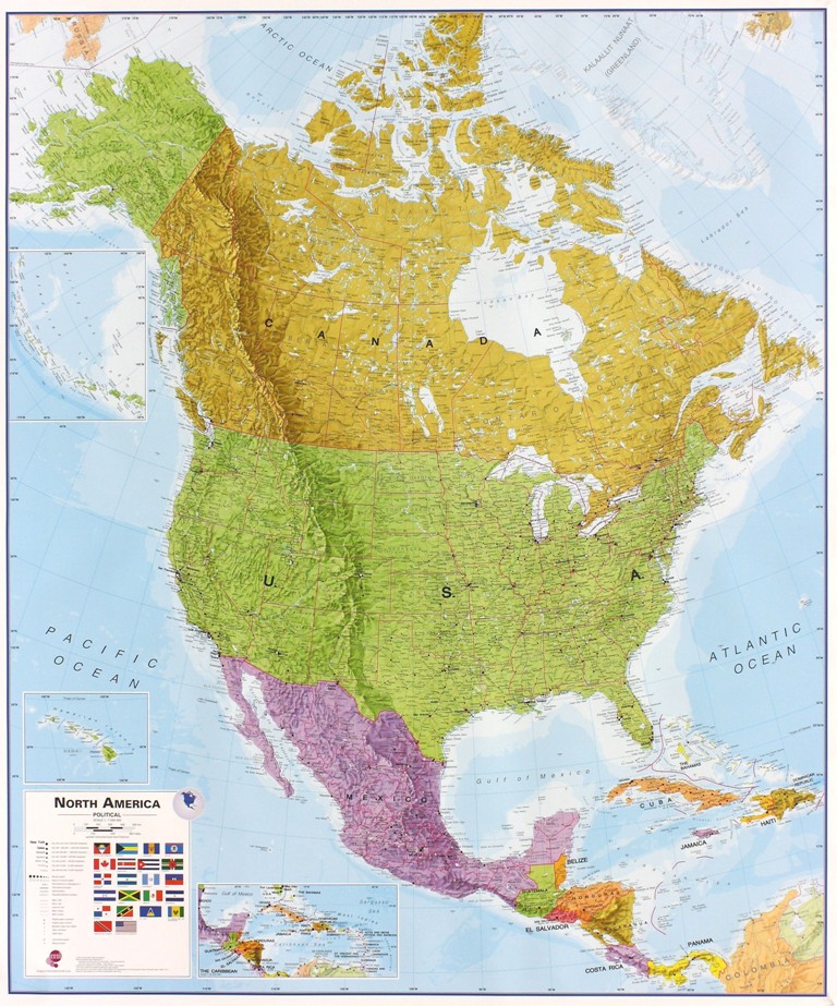
Fraaie politieke kaart van het continent, waarbij vooral de politieke aspecten heel duidelijk te lezen zijn. Alle landen hebben verschillende kleuren, steden en belangrijke verbindingen zijn goed te vinden. Dit is geplastificeerde uitvoering zonder ophangsysteem. Maps International's North America political wall map covers a huge expanse of land from Alaska and Canada through the United States down to Mexico, Central America and the Caribbean. One of the finest maps money can buy! This political wall map of North America features countries shown in different colours, international boundaries and major transport networks. The wall map also contains a panel of flags relating to the countries shown in this North American continent map. Also shown is city population detail, capital cities and all the major towns and cities in this continent of North America. Maps International's North America map is available either plain or laminated. Ideal for an office, classroom or when planning a trip to this American continent.
€38,95
Bekijk product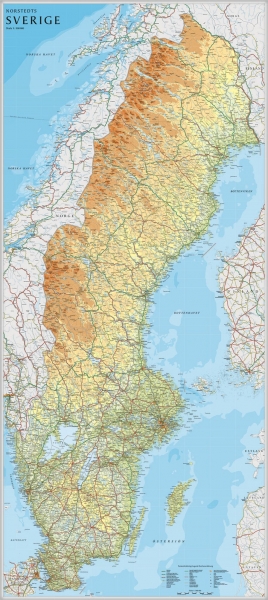
Een grote kaart van Zweden voor aan de muur. Decoratieve kleuren tonen verschillende hoogten en Zweedse bergketens. Belangrijke wegen, spoorwegen en steden zijn duidelijk herkenbaar. Wordt geleverd op rol in stevige kartonnen koker.
€42,95
Bekijk product
Prachtige wandkaart van China, waarbij zowel de politieke natuurkundige aspecten goed zichtbaar zijn. In rood zijn de belangrijkste toeristische hoogtepunten ingetekend. Kleurgebruik is vrij fel, maar daardoor wordt het geheel bijzonder mooi. De afmetingen zijn 120 x 88 cm. Hooggebergte, woestijnen, laagland en aanduidingen van hoogte vind je op de kaart. Ook een grote hoeveelheid plaatsen en de belangrijkste verbindingsroutes zijn ingetekend.
€49,95
Bekijk product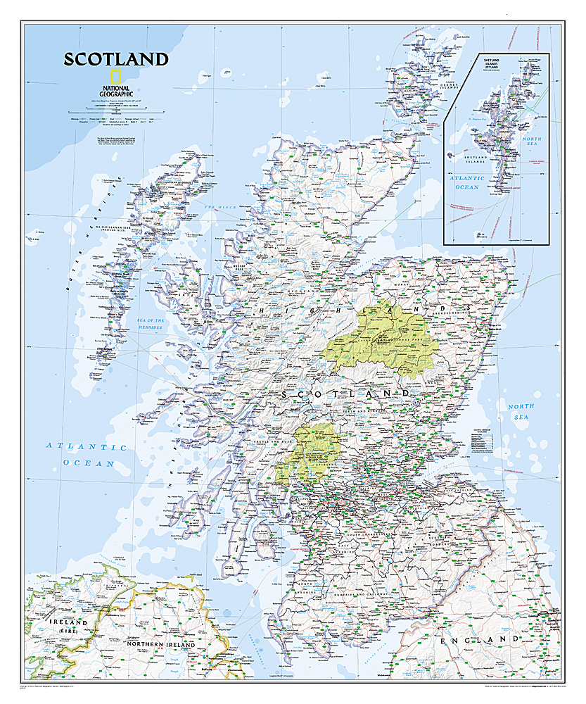
This new map of Scotland, features our rich, antique-inspired Executive style. This beautiful map includes thousands of place names, accurate political boundaries, national parks, archeological sites, and major infrastructure networks such as roads, canals, ferry routes, and railroads. Scotland’s diverse terrain is detailed through accurate shaded relief, coastal bathymetry, and symbolism for water features and other landforms.
€31,95
Bekijk product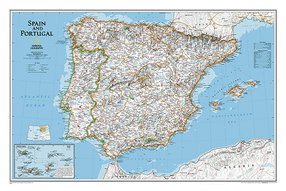
This classic-style map of Spain and Portugal shows political boundaries, major highways and roads, cities and towns, airports and other geographic details. Thousands of place-names and exact borders are carefully researched by National Geographic s map researchers and editors ensuring the utmost accuracy.
€31,95
Bekijk product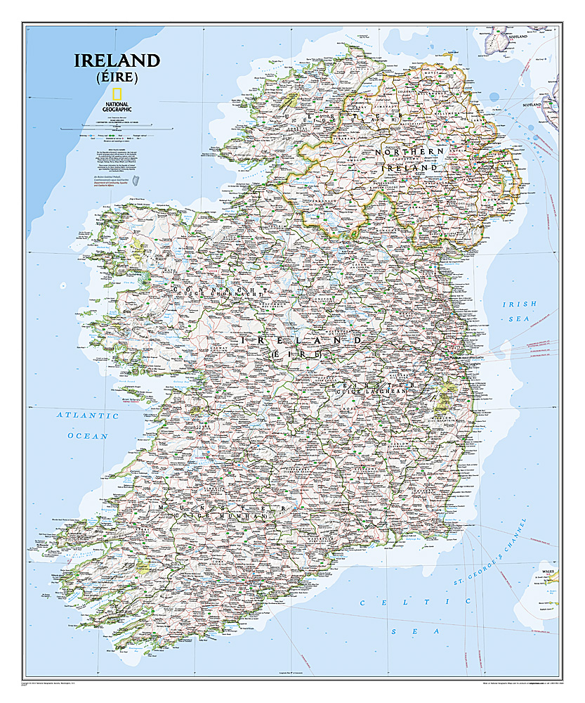
National Geographic Maps' new Ireland wall map is one of the most authoritative maps yet published of the Emerald Isle. Of the nearly 1,000 place-names shown on this map, all within the Republic of Ireland adhere to that nation's constitution—that the Irish and English language share official status. Thus, Gaelic (Irish) place-names, along with their English variants in parentheses, are shown within Irish-speaking regions while English place-names, along with their Gaelic variants, are shown outside these areas. Ireland Classic is ideal for those researching their Irish ancestry, a perfect tool for business reference, and a beautiful addition to any décor. It’s one of the largest and most detailed wall maps specifically for Ireland available today. Shown on the map are over 1,000 named places including primary and secondary towns, counties, political boundaries, infrastructure, and selected historical sites for both Ireland and Northern Ireland. Place-name Details: Per the Republic of Ireland’s constitution, the Irish and English languages share official status. In the Gaeltacht, or predominantly Irish-speaking regions, only Irish place-names have official status and are used on signposts. These districts are found within the counties of Cork, Donegal, Galway, Kerry, Mayo, Meath, and Waterford. Place-names information for the Republic of Ireland contributed by An Roinn Gnotai Pobail, Comhionannais agus Gaeltachta/ Department of Community, Equality and Gaeltacht Affairs.
€31,95
Bekijk product
National Geographic Wall Maps offer a special glimpse into current and historical events, and they inform about the world and environment. Offered in a variety of styles and formats, these maps are excellent reference tools and a perfect addition to any home, business or school. There are a variety of map options to choose from, including the world, continents, countries and regions, the United States, history, nature and space.
€25,95
Bekijk product
National Geographic Wall Maps offer a special glimpse into current and historical events, and they inform about the world and environment. Offered in a variety of styles and formats, these maps are excellent reference tools and a perfect addition to any home, business or school. There are a variety of map options to choose from, including the world, continents, countries and regions, the United States, history, nature and space.
€31,95
Bekijk product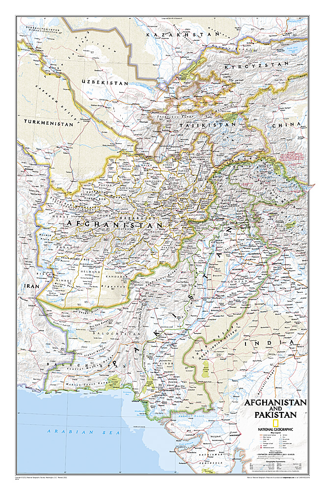
This is the latest and most detailed map of the region - a perfect complement for following today's news stories. Afghanistan's 34 administrative provinces and Pakistan's provinces and territorial boundaries are clearly delineated. The region's diverse terrain is expertly depicted in shaded relief and symbology, including the elevation of prominent mountains and ocean depths in meters. Superhighways, major roads, canals, railroads, oil infrastructure, and geologic features are detailed.
€28,95
Bekijk product