
Beantwoord enkele vragen, en binnen seconden geeft AI je een persoonlijk aankoopadvies op maat.
Beantwoord enkele vragen, en binnen seconden geeft AI je een persoonlijk aankoopadvies op maat.
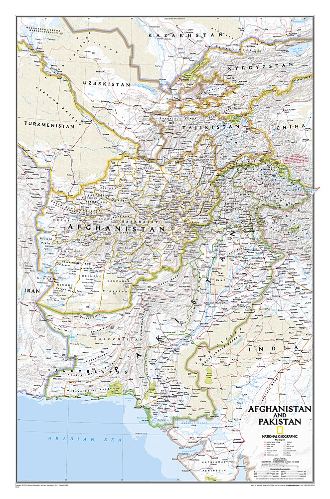
This is the latest and most detailed map of the region - a perfect complement for following today's news stories. Afghanistan's 34 administrative provinces and Pakistan's provinces and territorial boundaries are clearly delineated. The region's diverse terrain is expertly depicted in shaded relief and symbology, including the elevation of prominent mountains and ocean depths in meters. Superhighways, major roads, canals, railroads, oil infrastructure, and geologic features are detailed. This version is laminated—featuring a "write and wipe" surface and durable plastic covering.
€34,95
Bekijk product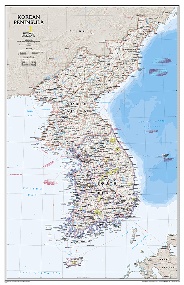
Amid increasingly combative rhetoric from Pyongyang, North Korea, do you know where its underground nuclear test site or missile launch centers are located? Are you aware that the South Korean government has begun a program to move its federal offices and personal from Seoul to a new location? National Geographic's new Korean Peninsula map provides this and much more information about this conflicted peninsula. National Geographic Maps' Korean Peninsula wall map is one of the most authoritative maps of the Koreas. The peninsula's rugged terrain is expertly depicted in shaded relief, including the elevation of prominent mountains and ocean depths in meters. This new edition clearly portrays both countries and uses the latest system for transcribing South Korean place-names from the Korean alphabet. In great detail, it delineates the latest administrative divisions of both countries along the historic demarcation line between the two Koreas. The map also portrays the transportation grid of both countries, including South Korea's high-speed passenger railway network.
€25,95
Bekijk product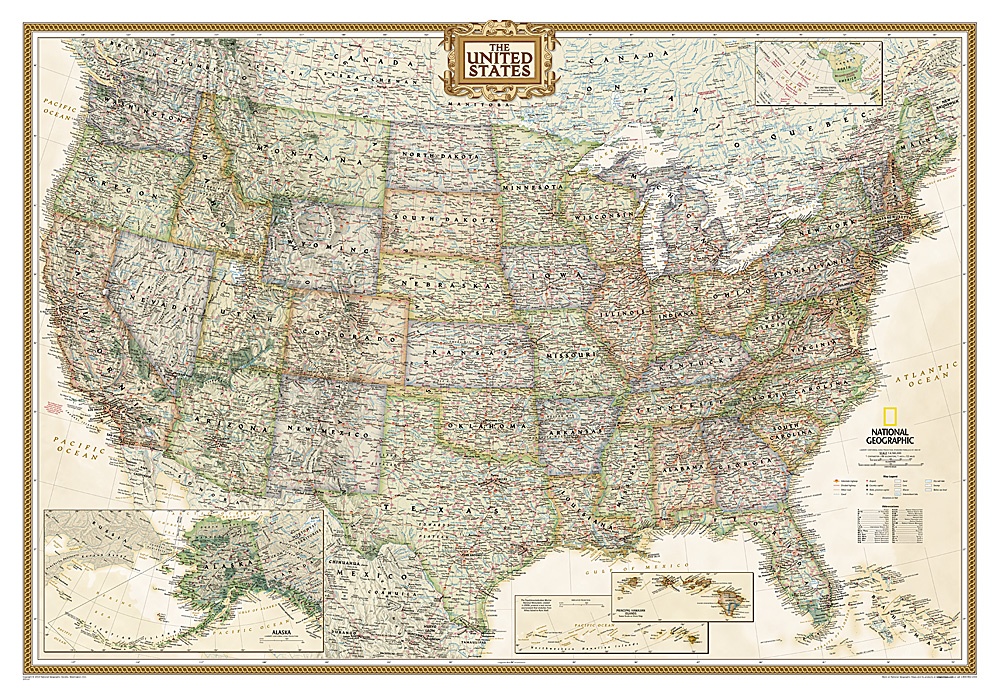
Wandkaart van de USA waarbij de kleuren in 'antieke' look zijn weergegeven, de staatgrenzen zeer duidelijk zijn en er veel plaatsen op staan. This Antique-style USA Wall Map by National Geographic Maps combines classic antique-style cartography with fully updated geographical representation. Displaying elegant use of earth-tone color and extensive detail for type placement to aid readability, this USA map is loaded with information. This USA wall map includes: State Boundaries Capitals and Cities National Parks, Monuments and Recreation Areas Airports and Air Force Bases US Interstates and Highways Physical Terrain Shading Latitude and Longitude Graticule Insets of Hawaiian Islands and Alaska Legend and Abbreviation List Includes portions of Canada and Mexico
€36,95
Bekijk product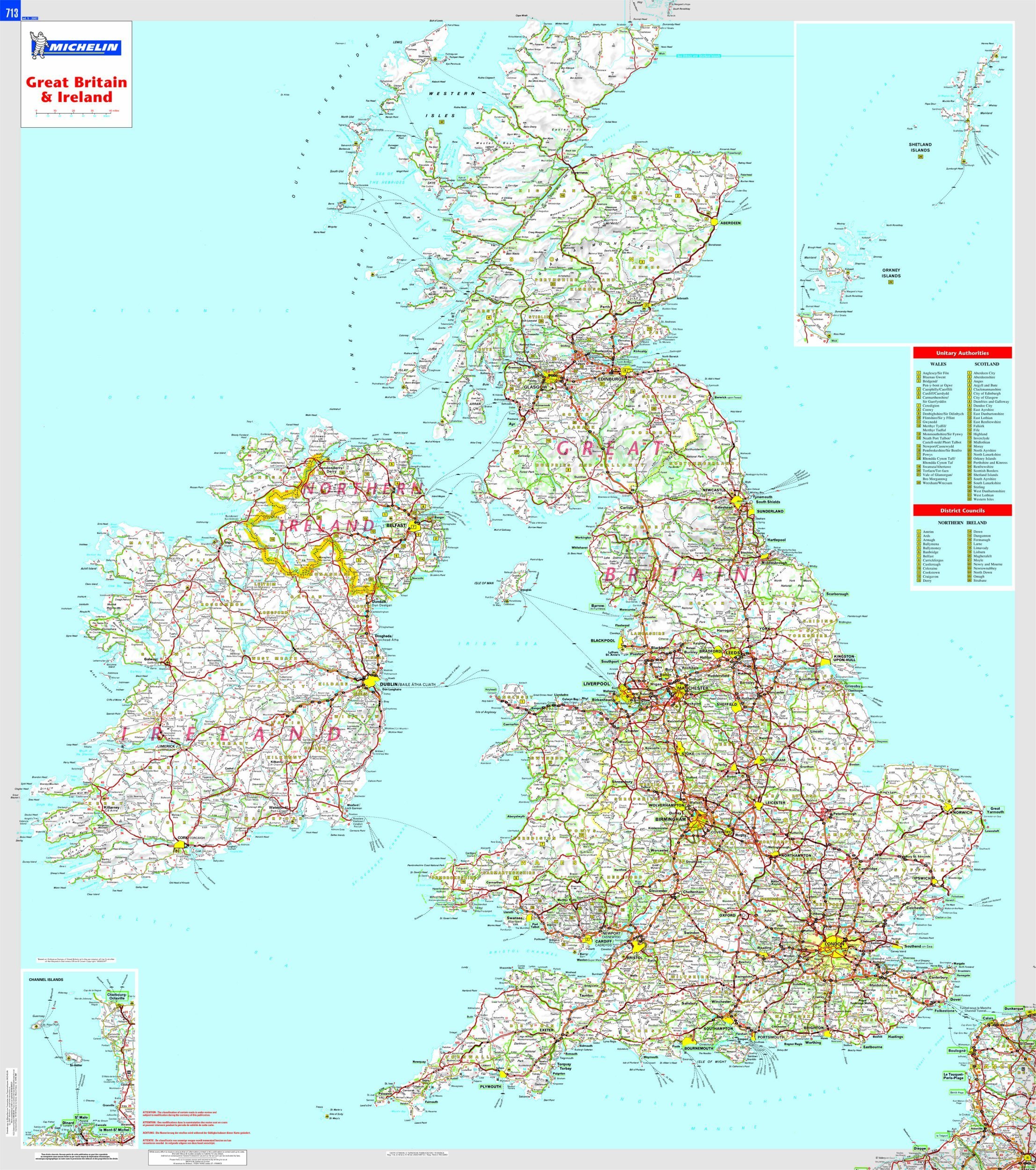
This Great Britain and Ireland wall map will give an overview of British and Irish cities, administrative boundaries, as well as primary and secondary road networks at a glance. This laminated map, suitable to use with marker pens, is presented on a scale 1/1,000,000 and measures 100 x 88 cm
€32,95
Bekijk product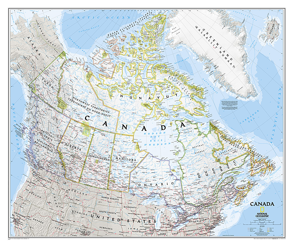
Decoratieve wandkaart van Canada. Naast de mooie kleuren staan er bijzonder veel plaatsen op vermeld. This beautiful wall-map from National Geographic depicts Canada and the areas surrounding the Great Lakes in beautiful and accurate detail. Included in the map are Canadian province and US State boundaries, cities and towns, lakes and waterways, major geographic features, roadways, and other geographic details. Our most detailed wall map of Canada, features the classic National Geographic reference styling. Features thousands of place names, accurate political boundaries, national parks, archeological sites, and major infrastructure networks such as roads, canals, ferry routes, and railroads. Canada s diverse terrain is detailed through accurate shaded relief, coastal bathymetry, and symbolism for water features and other landforms. This wall map depicts Canada and the areas surrounding the Great Lakes. Includes Canadian provinces and US State boundaries.
€34,95
Bekijk product
Our most detailed wall map of Canada, features the classic National Geographic reference styling. Features thousands of place names, accurate political boundaries, national parks, archeological sites, and major infrastructure networks such as roads, canals, ferry routes, and railroads. Canada’s diverse terrain is detailed through accurate shaded relief, coastal bathymetry, and symbolism for water features and other landforms. This wall map depicts Canada and the areas surrounding the Great Lakes. Includes Canadian provinces and US State boundaries.
€28,95
Bekijk product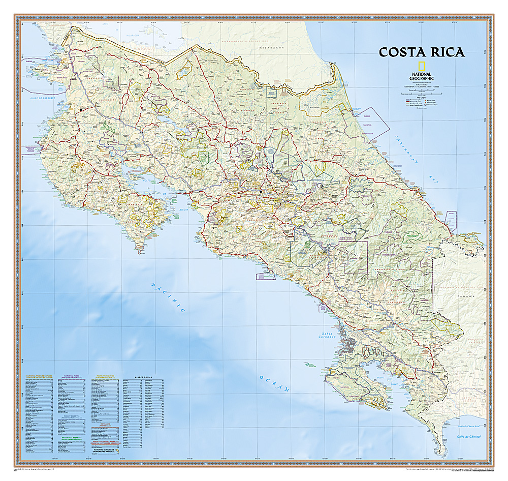
Decoratieve wandkaart van Costa Rica. Naast de mooie kleuren staan er bijzonder veel plaatsen op vermeld. This full-color map is a richly detailed rendering of one of Central America's greatest treasures. From its northern savannahs and plains to lush forests and pristine jungle-lined beaches, Costa Rica's beauty and diversity beckon! The map also includes outlines and information for National Parks, Protection Zones, and more.
€28,95
Bekijk product
The most accurate and richly detailed reference map available for the iconic Caribbean island nation, our Cuba Classic Map contains National Geographic’s proprietary fonts and world recognized border bands in a bright and appealing color palette with striking blue oceans on a crisp white background. Cuba’s many offshore islands, reefs, and rivers are noted, as are sites of interest. Ocean bathymetry with depth curves and soundings, peak elevations, and handcrafted shaded relief provide topographical detail. Jamaica, the Cayman Islands, the Florida Keys, and most of the Bahamas and Haiti are shown, presenting Cuba in the context of its important geographical position in the Caribbean. Cuba contains thousand of place names, accurate political boundaries, and infrastructure making it the perfect reference for student, home, or business. Additional content unique to this map includes: Sites of interest including national parks and reserves Geographic equivalents provide translations from Spanish to English Transportation detail including highways, roads, canals, ferry routes, and airports Geographical detail including mountain relief, swamps, and coastal reefs Elevations, depth curves, and soundings Coverage includes Havana, Pinar del Rio, Baracoa, Trinidad, Caya Largo, Santa Clara, Varadero, Isla de la Juventad
€28,95
Bekijk product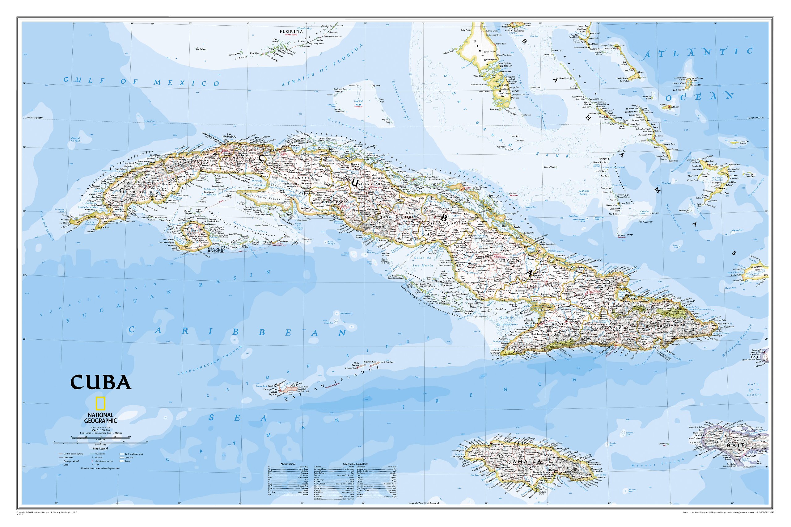
The most accurate and richly detailed reference map available for the iconic Caribbean island nation, our Cuba Classic Map contains National Geographic’s proprietary fonts and world recognized border bands in a bright and appealing color palette with striking blue oceans on a crisp white background. Cuba’s many offshore islands, reefs, and rivers are noted, as are sites of interest. Ocean bathymetry with depth curves and soundings, peak elevations, and handcrafted shaded relief provide topographical detail. Jamaica, the Cayman Islands, the Florida Keys, and most of the Bahamas and Haiti are shown, presenting Cuba in the context of its important geographical position in the Caribbean. Cuba contains thousand of place names, accurate political boundaries, and infrastructure making it the perfect reference for student, home, or business. Additional content unique to this map includes: Sites of interest including national parks and reserves Geographic equivalents provide translations from Spanish to English Transportation detail including highways, roads, canals, ferry routes, and airports Geographical detail including mountain relief, swamps, and coastal reefs Elevations, depth curves, and soundings Coverage includes Havana, Pinar del Rio, Baracoa, Trinidad, Caya Largo, Santa Clara, Varadero, Isla de la Juventad
€34,95
Bekijk product
Complete political actual detail of Germany - country boundaries, roads and cities, airports, bodies of water, and other geographic details in antique style.
€31,95
Bekijk product