
Beantwoord enkele vragen, en binnen seconden geeft AI je een persoonlijk aankoopadvies op maat.
Beantwoord enkele vragen, en binnen seconden geeft AI je een persoonlijk aankoopadvies op maat.
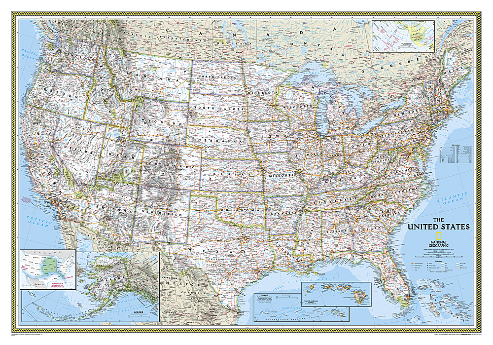
<p> Het klassieke kaartbeeld van National Geographic, de grenzen van de staten van Amerika zijn apart gekleurd. De wandkaart is heel gedetailleerd met veel plaatsen, wegen, rivieren en nationale parken, het reliëf wordt met schaduw aangegeven.</p> <div> The National Geographic Classic United States map uses bright color bands to outline each state. Capitals, major cities, selected towns, bodies of water, highways, and national parks are all shown. Shaded relief, rich in detail, emphasizes the many mountains, valleys, and plateaus of the United States. </div> <div> </div> <div> Our most popular United States wall map. Features all 50 States with insets for Alaska and Hawaii. All major cities, transportation routes, State boundaries, National Parks, inland waterways, and mountain ranges are clearly displayed and labeled. </div>
€28,95
Bekijk product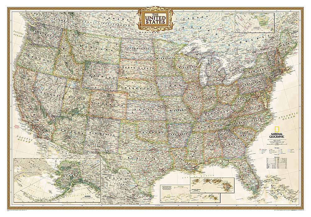
<p> Wandkaart van de USA waarbij de kleuren in 'antieke' look zijn weergegeven, de staatgrenzen zeer duidelijk zijn en er veel plaatsen op staan.</p> <p> This Antique-style USA Wall Map by National Geographic Maps combines classic antique-style cartography with fully updated geographical representation. Displaying elegant use of earth-tone color and extensive detail for type placement to aid readability, this USA map is loaded with information.</p> <p> This USA wall map includes:</p> <p> State Boundaries<br /> Capitals and Cities<br /> National Parks, Monuments and Recreation Areas<br /> Airports and Air Force Bases<br /> US Interstates and Highways<br /> Physical Terrain Shading<br /> Latitude and Longitude Graticule<br /> Insets of Hawaiian Islands and Alaska<br /> Legend and Abbreviation List<br /> Includes portions of Canada and Mexico</p>
€28,95
Bekijk product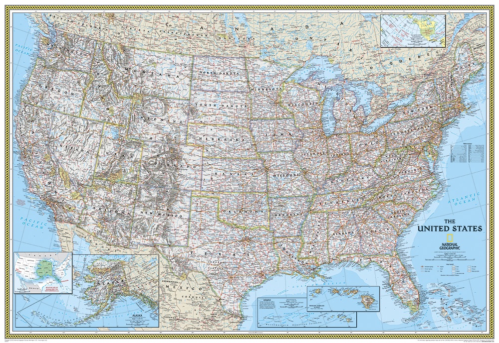
<p> </p> <div> Het klassieke kaartbeeld van National Geographic, de grenzen van de staten van Amerika zijn apart gekleurd. De wandkaart is heel gedetailleerd met veel plaatsen, wegen, rivieren en nationale parken, het reliëf wordt met schaduw aangegeven. Geplastificeerde versie.</div> <div> </div> <div> The National Geographic Classic United States map uses bright color bands to outline each state. Capitals, major cities, selected towns, bodies of water, highways, and national parks are all shown. Shaded relief, rich in detail, emphasizes the many mountains, valleys, and plateaus of the United States. </div> <div> </div> <div> Our most popular United States wall map. Features all 50 States with insets for Alaska and Hawaii. All major cities, transportation routes, State boundaries, National Parks, inland waterways, and mountain ranges are clearly displayed and labeled. </div>
€36,95
Bekijk product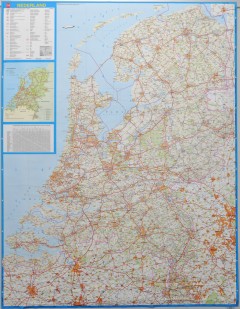
<p> Wandkaart - Falk Nederland met een formaat van 130 (h) X 100 (b) cm. Het is een zeer gedetailleerde en duidelijke wandkaart, met veel plaatsen, wegen met wegnummers, afritten. Deze kaarten zijn echt gericht op plaatsen en wegen, natuurgebieden zijn minder duidelijk aangegeven.</p>
€39,95
Bekijk product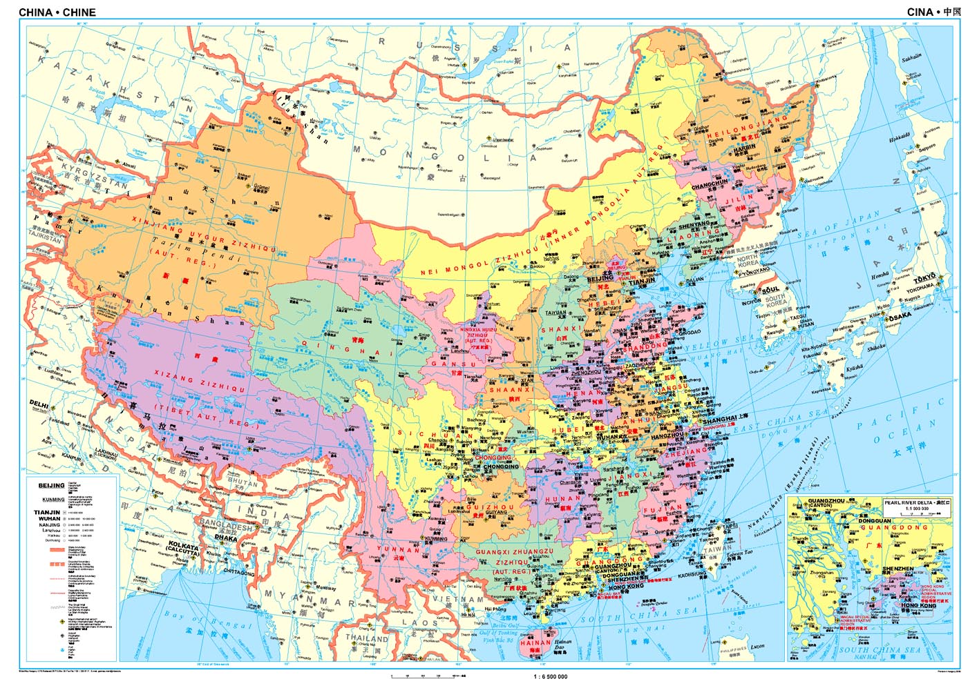
<p> Een wandkaart van China waarop de politieke grenzen en steden tweetalig staan weergeven. Natuurkundige aspecten zijn weggelaten, maar dat komt de politieke en bestuurlijke indeling duidelijk ten goede.</p> <p> Afmetingen: 69cm.x 95cm. (hxb)</p> <div> An administrative wall map of China at 1:6,500,000, size 96 x 68cm (38" x 27" approx), from Gizi Map showing the division of the country into provinces. All place names are given in both Chinese and Latin alphabet. Hong Kong and the Pearl River Delta are presented in a greater detail on an inset.</div> <div> </div> <div> China’s provinces are shown in bright contrasting colours. Town symbols indicate the size of the population. Main airports and ports are marked, as well as coastal and international shipping routes, Topographic information is limited to the network of rivers. Latitude and longitude lines are at 5° intervals. The map is not indexed. Multilingual map legend includes English. An inset shows Hong Kong and the Pearl River Delta region at 1:1,000,000.</div>
€46,95
Bekijk product
<p> Mooi, heldere wandkaart van Canada.</p> <div> </div> <div> This Canada wall map clearly depicts all the cities, major roads and also shows all the Provinces and Territory boundaries. All major cities and areas are displayed bi-lingually.</div> <div> </div> <div> This Canada Wall Map features:</div> <div> • Provincial Boundaries</div> <div> • Provincial Capitals</div> <div> • Cities</div> <div> • National and International Airports</div> <div> • Latitude and Longitude Lines</div> <div> • Physical Features and Terrain Shading</div> <div> • Ocean Bathymetry</div> <div> • Highways, Major Roads and Seasonal Roads</div> <div> • Provincial Flags</div> <div> • Provincial and National Parks</div> <div> • Detailed Scale: 1:5,700,000</div>
€38,95
Bekijk product
<p> Prachtige wandkaart van China, waarbij zowel de politieke natuurkundige aspecten goed zichtbaar zijn. In rood zijn de belangrijkste toeristische hoogtepunten ingetekend. Kleurgebruik is vrij fel, maar daardoor wordt het geheel bijzonder mooi. De afmetingen zijn 120 x 88 cm.</p> <p> Hooggebergte, woestijnen, laagland en aanduidingen van hoogte vind je op de kaart. Ook een grote hoeveelheid plaatsen en de belangrijkste verbindingsroutes zijn ingetekend.</p> <p> </p>
€49,95
Bekijk product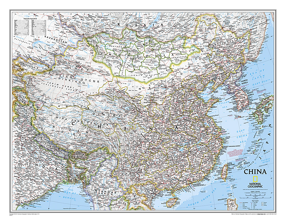
<p> Decoratieve wandkaart van China. Naast de mooie kleuren staan er bijzonder veel plaatsen op vermeld. Het gaat soms een beetje ten kosten van de schoonheid van de kaart, maar daardoor wel zeer volledig.</p> <p> This detailed political map of China by National Geographic accurately shows locations of provincial boundaries, cities and towns, major highways and roads, rivers and waterways, and other geographic features. Mongolia is also fully included in the map, as well as portions of many other surrounding countries.</p> <p> </p>
€25,95
Bekijk product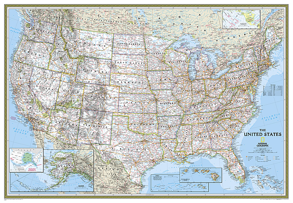
<p> Het klassieke kaartbeeld van National Geographic, de grenzen van de staten van Amerika zijn apart gekleurd. De wandkaart is heel gedetailleerd met veel plaatsen, wegen, rivieren en nationale parken, het reliëf wordt met schaduw aangegeven. Dit is de grote versie (zie afmetingen)</p> <div> </div> <div> The National Geographic Classic United States map uses bright color bands to outline each state. Capitals, major cities, selected towns, bodies of water, highways, and national parks are all shown. Shaded relief, rich in detail, emphasizes the many mountains, valleys, and plateaus of the United States. </div> <div> </div> <div> Our most popular United States wall map. Features all 50 States with insets for Alaska and Hawaii. All major cities, transportation routes, State boundaries, National Parks, inland waterways, and mountain ranges are clearly displayed and labeled. </div>
€49,95
Bekijk product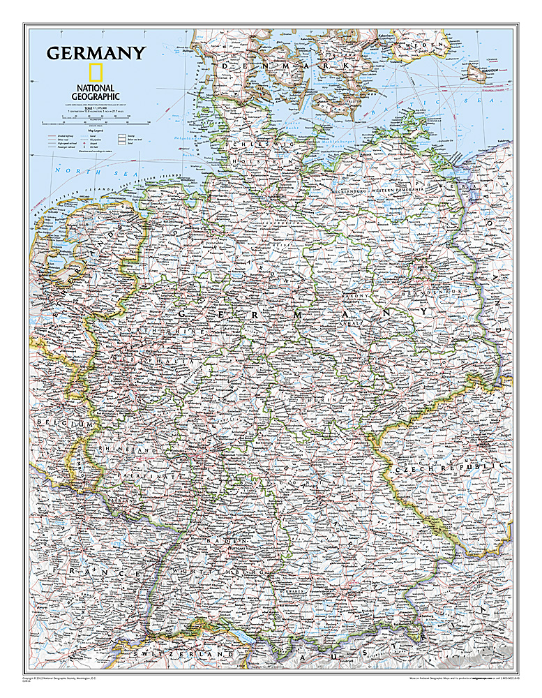
<p> Decoratieve wandkaart van Duitsland. Naast de mooie kleuren staan er bijzonder veel plaatsen op vermeld.</p> <p> </p> <p> National Geographic's political map of Germany includes everything from country boundaries, major roads, towns and cities, airports, bodies of water, and other geographic details. It's a great addition to any classroom, office, or home.</p> <p> </p>
€25,95
Bekijk product